Big Sur / Monterey Bay
Los Padres National Forest
Mammoth Lakes ~ Lake Sabrina
Kings Canyon / National Parks
Willamette National Forest
The Redwood Empire
Fishing California
Humboldt 101
Fishing California
 
How to Catch a Fish

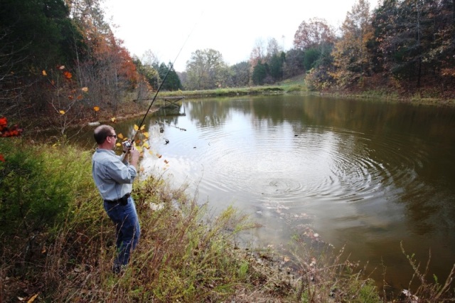
There's an old angler's joke about how you need to think like a fish. The irony is that it is your mental approach, what you see and what you miss, that often determines your fishing luck. Some people will spend a lot of money on tackle, lures, and fishing clothes, and that done, just saunter up to a stream or lake, cast out, and wonder why they are not catching fish. The answer is their mental outlook. They are not attuning themselves to their surroundings.

You must live on nature's level, not your own. Try this and you will become aware of things you never believed even existed. Soon you will see things that will allow you to catch fish. You can get a head start by reading about fishing, but to get your degree in fishing, you must attend the University of Nature.

Regardless what you fish for, follow three hard-and-fast rules...
  1. Always approach the fishing spot so you will be undetected.
  2. Make your lure, fly, or bait appear as if no line was attached.
  3. Stick and move. Hit one spot as best you can, then moving to the next.

  1. Approach

    No one can just walk up to a stream or lake, cast out, and start catching fish as if someone had waved a magic wand. Instead, give the fish credit for being smart. After all, they live there.

    Your approach must be completely undetected by the fish. Fish can sense your presence through sight and sound, though this is misinterpreted by most people. By sight, this rarely means the fish actually see you; more likely they will see your shadow on the water or the movement of your arm or rod while casting. By sound, it doesn't mean they hear you talking, but that they will detect the vibrations of your footsteps along the shore, kicking a rock, or the unnatural plunking sound of a heavy cast hitting the water. Any of these elements can spook them off the bite. In order to fish undetected, you must walk softly, keep your shadow off the water, and keep your casting motion low. All of these keys become easier at sunrise or sunset, when shadows are on the water. At midday a high sun causes a high level of light penetration in the water, which can make the fish skittish to any foreign presence.

    Like hunting, you must stalk the spots. When my brother Rambo sneaks up on a fishing spot, he is like a burglar sneaking through an unlocked window. The rule of the wild is that wildlife will congregate wherever there is a distinct change in habitat. To find where fish are hiding, look where a riffle pours into a small pond, where a rapid plunges into a deep hole and flattens, and around submerged trees, rock piles, and boulders in the middle of a long riffle.

  2. Presentation

    Your lure, fly, or bait must appear in the water as if no line were attached, so it looks as natural as possible. My pal Mo Furniss has skin-dived in rivers to watch what the fish see when somebody is fishing.

    "You wouldn't believe it," he said. "When the lure hits the water, every trout within 40 feet, like 15, 20 trout, will do a little zigzag. They all see the lure and are aware something is going on. Meanwhile, onshore the guy casting doesn't get a bite and thinks there aren't any fish in the river."

    If your offering is aimed at fooling a fish into striking, it must appear as part of its natural habitat, like an insect just hatched or a small fish looking for a spot to hide. That's where you come in.

    After you have sneaked up on a fishing spot, you should zip your cast upstream and start your retrieval as soon as it hits the water. If you let the lure sink to the bottom and then start the retrieval, you have no chance. A minnow, for instance, does not sink to the bottom, then start swimming. On rivers, the retrieval should be more of a drift, as if the "minnow" is in trouble and the current is sweeping it downstream.

    When fishing on trout streams, always hike and cast upriver and retrieve as the offering drifts downstream in the current. This is effective because trout will sit almost motionless, pointed upstream, finning against the current. This way they can see anything coming their directors, and if a potential food morsel arrives, all they need to do is move over a few inches, open their mouths, and they've got an easy lunch. Thus you must cast upstream.

    Conversely, if you cast downstream, your retrieval will bring the lure from behind the fish, where he cannot see it approaching. And I've never seen a trout that had eyes in its tail. In addition, when retrieving a downstream lure, the river current will tend to sweep your lure inshore to the rocks.

  3. Finding Spots

    A lot of anglers don't catch fish. The key is where they are looking. The rule of the wild is that fish (and other wildlife) will congregate wherever there is a distinct change in the habitat. This is where you should begin your search.

    In a river, it can be where a riffle pours into a small pool, a rapid that plunges into a deep hole and flattens, a big boulder in the middle of a long riffle, a shoreline point, a rock pile, a submerged tree. Look for the changes. Conversely, long, straight stretches of shoreline will not hold fish ~ the habitat is lousy.

    On rivers, the most productive areas are often where short riffles tumble into small oxygenated pools. After sneaking up from the downstream side and staying low, you should zip your cast so the lure plops gently into the white water just above the pool. Start your retrieval instantly; the lure will drift downstream and plunk into the pool. Bang! That's where the trout will hit. Take a few more casts and then head upstream to the next spot.

    With a careful approach and lure presentation and by fishing in the right spots, you have the ticket to many exciting days on the water.


Angler Ethics...

  • Be absolutely fire-safe. Never figure, "It'll be OK."
  • Keep only the fish you will eat. Never waste a fish.
  • Share information with those new to the sport. Never be rude.
  • Never trespass. Have a map before venturing to hike-in streams.
  • Never litter. Bring a plastic bag to pick up any litter you come across.
  • Conduct yourself quietly in campgrounds. Never disturb your neighbor.
  • Check state fishing regulations prior to fishing any water. Never guess.
  • Take personal responsibility for practicing absolutely safe boating skills.
  • Call the toll-free poacher hot line (888)334-2258 if you see illegal activity.
  • Give support to the organization that best protects your favorite fishery.


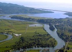
American River
from Fair Oaks to Sacramento
American River
American River #7 Chinook/King Salmon
#7 Chinook/King Salmon
American River #8 Steelhead
#8 Steelhead

Don't like the action? Just stick around. On the American River, it always seems as if another run of fish is on the way.

Steelhead arrive from December through mid-March; shad from late April through early July; striped bass in April, May, and June; and salmon from September through November. By December the cycle starts anew. No fish? What, me worry?

This section of the American flows from the outlet at Nimbus Basin on downstream past Fair Oaks and Rancho Cordova before entering the Sacramento River at Discovery Park. In that span, several spots offer excellent access by boat or by bank (although chest waders are a necessity at some).

The upper river (see DFG regulations) is closed from October 16 through December 31 to all fishing. When it reopens on January 1, the river is full of steelhead and steelhead anglers. Many fish are caught the first few days, then it tapers off to more typical results for steelhead.

Bank fishers use Glo-Bugs, night crawlers, and spinners such as the Blue Fox and Mepps to get their fish. Anglers in drift boats pull plugs such as Hot Shots and Wee Warts, and occasionally use roe for their fish.

The peak of the salmon run in the American River occurs during late September and October. The lower river has three major areas where toners catch tons of fish: the two dredger holes on the lower river, one below the 16th Street Bridge, and one above it. Another good spot is the run behind Sacramento State University, accessed by either boat ramp on the south side of the Howe Avenue Bridge.

Above that, riffles and runs are fished by bank fishers or by the occasional drift-boat angler. On the upper river, there are unimproved boat ramps near the Sunrise Bridge and also from an access road a mile upstream. Small boats are put in and anchored here, letting Kwikfish or Flatfish wobble in the river current. This is best during the end of the open season, which ends October 15. Limits are the rule. The sardine wrap on the Kwikfish and Flatfish lures makes a big difference here; be sure to use it.

Some bank anglers still use the traditional methods of casting spinners and wobblers like Mepps and Krocodiles to catch their salmon. One of my favorite spots in May is Goethe Park, where I walk downstream a bit, then wade in and start casting for shad. There's a footbridge overhead, and from it kids can often see the shad and tell me where to cast. Cheating? Maybe, but I release all the fish anyway. Another favorite spot is Sunrise Avenue; many more shad are caught in that area than at Goethe Park, but it's usually loaded with anglers.

The shad need decent water flows to be attracted upstream, and when that happens, the American is one of the best shad rivers anywhere. The same is true for the other anadromous species that migrate here: salmon, steelhead, and striped bass. However, the converse is also true. If the flows are very low, as can be the case, the river turns into a skunk-hole. Little water equals few fish.

In the best years, the late-summer striped bass fishing is best in the section of river just upstream from its confluence with the Sacramento River. You need a boat to have much of a chance. Salmon and steelhead, on the other hand, are sprinkled throughout the river all the way to Nimbus Basin during fall and winter, and they can be caught from shore as well as from a boat.

Facilities, fees: Boat ramps are provided at Discovery Park and near Watt Avenue. Campgrounds, lodging, and supplies are in the Sacramento area. Restrooms with flush toilets, drinking water, picnic areas, and barbecues are at many river-access points. Fishing access is free.

Directions: Easy access is off the roads in Rancho Cordova and Fair Oaks that cut off from U.S. 50. Excellent shore-fishing access is at the following locations: Nimbus Basin, Ancil Hoffman Park, Goethe Park, the Sunrise Avenue access areas, the Watt Avenue Bridge area, Paradise Beach, the area behind Cal Expo, and Dredger Hole. By boat, the best and most easily accessible spot is at the confluence of the Sacramento and American Rivers in Discovery Park, in Sacramento.


Bear River Reservoir
southwest of Lake Tahoe in Eldorado National Forest

Bear River Reservoir
Bear River Reservoir #5 Mackinaw Trout
#5 Mackinaw Trout

As you venture into the mountains on Highway 88, this is the first of three quality mountain lakes you will come to. Silver Lake and Caples Lake round out the trio.

With a lower elevation (at 5,800 feet), Bear River Reservoir has an advantage over the others. The ice here melts off sooner than at Silver and Caples Lakes; correspondingly, the spring stocks and fishing get going earlier, too.

Another edge is that the reservoir gets a double-barreled dose of trout, receiving plants from both the Department of Fish and Game and from the private resort here (Bear River Resort), which adds bonus trophy fish. The DFG stocks the lower reservoir with rainbows, browns, and brookies ~ all in the 10- to 12-inch class. On top of that, the resort dumps in thousands more trout. These plants join a small resident population of large brown trout.

You get the picture: lots of fish. Almost every week someone catches a trout in the 5- to 10-pound class. The people at the resort do a good job of providing detailed fish reports.

This is a deep, decent-sized lake, at 725 acres. During the summer, most trolleys use leadcore trolling line to get the desired depth ~ and catch the majority of the fish. People shore fishing at the campgrounds on either side of the boat ramp on the western end of the lake do only fair. The upper lake has primarily small rainbow trout (linkers galore), but it does provide a decent short hike. On summer weekends, campground reservations are essential.

Facilities, fees: A boat ramp, a small marina with fishing boat, kayak and canoe rentals, lodging, a grocery store, a restaurant, coin laundry, a lounge, campgrounds, restrooms with flush toilets and showers, a playground, volleyball, a beach area, and a game room are nearby. Fishing access is free.

Directions: From Stockton, drive east on Highway 88 for 80 miles (through foothill country and into the mountains) to the Bear River Road/resort area entrance on the right. Turn right and drive about 2 miles to a junction with the resort entrance road (if you drive over the dam, you have gone .25 mile too far). Turn left on the resort entrance road and drive a half mile to the entrance on the right.

Contact: Eldorado National Forest, Amador Ranger District, 209/295-4251, fax 209/2955994; Eldorado National Forest Visitor Information Center, 530/644-6048; Bear River Lake Resort, 209/295-4868, website: www.bearriverlake.com; Dale's Foothill Fishing, 530/2950488, website: www.dalesfoothillfishing.com.


Big Bear Lake
northeast of San Bernardino in San Bernardino National Forest

Big Bear Lake
Big Bear Lake #7 Trout
#7 Trout

Here is a lake that has it all: Big Bear Lake is big and beautiful; it has good trout fishing, quality boating opportunities, many campgrounds, and a few resorts; and it is located near the highest regions of San Bernardino National Forest. Alas, at times it can also have a lot of people. As I said, it's got everything.

Big Bear is set at 6,743 feet, and its beauty is unmatched by the other waters in the region. In the spring, the surrounding snowcapped ridge makes a striking contrast. The lake covers some 3,000 acres, has 22 miles of shoreline, and is a favorite vacation destination for faithful locals ~ and even those from farther afield, making this something like the Lake Tahoe of Southern California.

Trout fishing? It's often very good. Big Bear gets huge numbers of rainbow trout, courtesy of the Department of Fish and Game. They join a good population of holdover fish from

I previous years' stocks, as survival rates are quite good. You'll get the best results by slow trolling adjacent to the shoreline. The best spots are from Eagle Point west to the dam.

In the summer months, the fishery here can become primarily an early-morning/late-evening affair, as the water becomes the domain of water-skiers during the midday hours. There is also a sprinkling of largemouth and smallmouth bass, bluegill, and crappie, sunfish, catfish, and carp. A great fishing tournament is held here every May, right when fishing is the best.

For wild-trout fly fishers, nearby Bear Creek, below Big Bear Lake, provides an option. Getting there involves a .25-mile hike. For hikers, the Pacific Crest Trail passes just a few miles north of the lake. Easy trailhead access is available, so if you want to break away from the crowds and take a hike, you can.

Fish, boat, camp, and hike ~ you can do it all at this prime Southern California destination. Just don't expect to have the place to yourself.

Facilities, fees: There are campgrounds, cabins, lodging, picnic areas, full-service marinas, boat ramps, boat rentals, bait, tackle, and groceries. Boats more than 26 feet are prohibited. At most campgrounds, drinking water and flush toilets are provided. A boating permit, available by day or by annual pass, is required and can be purchased at most marinas. A day-use fee is charged.

Directions: From San Bernardino, turn north on Highway 18. Drive 15 miles to the Arrowhead Ranger Station. Continue east for about 15 more miles to Big Bear Lake.

The following are directions to the lake's marinas, as well as information on their facilities:

  • To Big Bear Marina: Take Highway 18 (on the lake's south shore) toward Big Bear Lake Village to Paine Road/Highway 18 (look for the big wooden arch that goes across the road). Turn left on Paine Road and continue about two blocks to the marina. Fishing boats, pontoon boats, personal watercraft, pedal boats, canoes, and kayaks are for rent. Storage docks, moorings, a boat ramp, tackle, and driver service are available.
  • To Holloway's Marina & RV Park: Take Highway 18 (on the lake's south shore) toward Big Bear Lake Village. Continue over the dam and drive three miles to Edgemore Street (look for the Log Cabin Restaurant). Turn left on Edgemore Street and drive about .5 mile to the marina. Fishing boats, pontoon boats, sailboats, pedal boats, and personal watercraft are for rent. Docks, moorings, a boat ramp, gas, bait and tackle, and groceries are available.
  • To Municipal Water District East Launch: Take Highway 18 (on the lake's south shore) toward Big Bear Lake Village. Continue to the dam and the junction with Highway 38. Turn east on Highway 38 and drive nine miles to the public launch (it's well signed) on the northeast shore.
  • To Municipal Water District West Launch: Take Highway 18 (on the lake's south shore) toward Big Bear Lake Village. Continue to the dam and the junction with Highway 38. Turn east on Highway 38 and drive 2.5 miles to the public launch (well signed) on the northwest shore.
  • To Pine Knot Landing: Take Highway 18 (on the lake's south shore) toward Big Bear Lake Village to Pine Knot Road (the first stop sign after the wooden arch that goes across the road). Turn left on Pine Knot Avenue and drive to the marina, at the road's end. Fishing boats, pontoon boats, speedboats, personal watercraft, sailboats, kayaks, and canoes are for rent. Docks, mooring, slips, storage, bait and tackle, a small store, boat tours, parasailing, and waterskiing, wakeboarding and knee-boarding lessons are available.
  • To Pleasure Point Marina: Take Highway 18 (on the lake's south shore) toward Big Bear Lake Village. Continue over the dam and drive two miles to Cienega Way. Turn left on Cienega Way and drive .5 mile to Landlock Landing Road. Turn right and drive into the marina. Docks, moorings, boat storage, bait and tackle, a snack bar, and rentals for fishing boats, pontoon boats, pedal boats, and canoes are available.
  • To North Shore Landing: Take Highway 18 (on the lake's south shore) toward Big Bear Lake Village. Continue to the dam and the junction with Highway 38. Turn east on Highway 38 and drive two miles to the marina. Fishing boats, sailboats, personal watercraft, speedboats, pontoon boats, canoes, and kayaks are available. Driver service, pirate-ship cruises (summer only), and lessons for sailing, water-skiing, wakeboarding, and knee boarding are available, as are docks, moorings, bait and tackle, and a snack bar.
  • To Big Bear Shores & RV Resort: Take Highway 18 (on the lake's south shore) toward Big Bear Lake Village. Continue to the dam and the junction with Highway 38. Turn east on Highway 38 and drive 6.5 miles to the resort. Fishing boats and pontoon boats are for rent. Docks and moorings are available.

Contact: Big Bear Discovery Center, 909/8663437; San Bernadine National Forest, Mountaintop Ranger District, 909/337-2444; Big Bear Municipal Water District, 909/866-5796, website: www.bbmwd.org; Big Bear Lake Resort Association, 909/866-6190 or 800/244-2327 (800/BIG-BEAR).

Marinas: Big Bear Marina, 909/866-3218; Holloway's Marina & RV Park, 909/866-5706 or 800/448A335; Municipal Water District East Laun4, 909/866-5200; Pine Knot Landing, 909/866-2628; Pleasure Point Marina, 909/866-2455; North Shore Landing, 909/8784386, website: www.bigbearboating.com; Big Bear Shores & RV Resort, 909/878-4386.

Additional boat rentals: Gray's Boat Landing, 909/866-2443; Family Boat Center, 909/8662433; Lighthouse RV Resort/Marina, 909/ 866-9464.


Big Lagoon
Rocky Point (Long Beach) north of Trinidad
Rocky Point (Long Beach)
Rocky Point (Long Beach) #10 Yellowtail
#10 Yellowtail

Of the three lagoons along this stretch of U.S. 101, it is Big Lagoon that gets the least amount of fishing pressure.

A lot of out-of-towners cruising by on U.S. 101 think (at first glance) that Big Lagoon is filled with saltwater, not freshwater. They probably have this misconception because Big Lagoon is west of U.S. 101, and it's barely separated from the ocean by a long, thin sand dune. But freshwater it is; Big Lagoon provides trout fishing in this unusual coastal setting.

A chance for steelhead is available here when winter storms raise the level of the lagoon enough to breach the sandbar that separates it from the ocean. The fish don't spend too much time in the lagoon proper. They tend to make tracks for the creek that feeds it. Trolleys pulling plugs such as Wiggle Warts and Hot Shots intercept a few bright steelhead each season as the fish head toward their natal stream. Some sea-run cutthroat trout also inhabit Big Lagoon; they will smack chartreuse/orange Little Cleo spoons or inflated night crawlers fished in the extreme northern corner of the lake.

This is a fun place to plunk in a canoe, paddle around, and catch a few trout in the process. Access is easy, and campsites are available nearby. Regardless, it is rare that anybody paddles around on the lagoon. They just keep on driving by, day after day, on U.S. 101. After all, they think it's saltwater.

Facilities, fees: A boat ramp, drinking water, and restrooms with flush toilets are available. Trinidad has two tackle shops: Salty's and Bob's Boat Basin. Campgrounds are at Patrick's Point State Park in Trinidad and at Stone Lagoon, to the immediate north. There is a camping fee. Access is free. Pets are permitted. There is a parking fee.

Directions: From Eureka, drive 22 miles north on U.S. 101 to Trinidad. At Trinidad, continue north on U.S. 101 for eight miles to Big Lagoon Park Road. Turn left (west) at Big Lagoon Park Road and drive two miles to the park.

Contact: Humboldt Lagoons State Park Visitors Center, 707/488-2041, website: www.parks.ca.gov (click on Find A Park); Humboldt County Parks, 707/445-7651; North Coast Adventures, 707/6773124; Salty's Surf 'n Tackle, 707/677-0300.


Blue Lakes, Alpine County
south of Lake Tahoe in Humboldt-Toiyabe National Forest
Blue Lake, Alpine County
Blue Lake, Alpine County #6 Trout
#6 Trout

The water is cold and the fishing can be hot at this spot in the high country, set at 8,200 feet. Both Upper and Lower Blue Lakes, which are linked by Middle Blue Creek, are among the most consistent producers of rainbow trout in the region.

The access road to both of these lakes runs on only one side. Bank anglers will always fish near the access road. With a boat, always fish the far side, and if you don't have a boat, be willing to hike to it.

Upper Blue seems to be the better choice for shoreline fishing, particularly the area stretching west from the boat ramp for about 200 yards. Lower Blue is decent from the shore, but trolling from a boat can be deadly dull. The north end of that lake, just past the drop-off, provides the best results. Both are well stocked. Upper Blue gets 10- to 12-inch rainbow trout and bonus cutthroat fingerlings. Lower Blue receives 10- to 12-inch rainbow trout and fingerling brook trout.

The first time I fished the Blue Lakes was on a trip to nearby Hope Valley, where the mission was to fish the Carson River, then head over to the Rubicon. But the Carson was a zilch that day, and a freak snowfall blocked access to the Rubicon. So it was off to the

Blue Lakes, which had just become ice-free co and had a clear access road. Turned out to be the best insurance policy for a fishing trip that I could've wanted. Now when I visit this area, I come here first and keep the Carson and Rubicon in mind as possible side trips.

Facilities, fees: campground, vault toilets, and drinking water are nearby. There is a boat ramp. Fishing access is free. A boat-launching fee is charged.


Bodega Bay Deep Sea
north of San Francisco
Bodega Bay north of San Francisco
Bodega Bay #8 Albacore
#8 Albacore

A gold mine of fish and good times is turning Bodega Bay into one of the best fishing spots on the coast. The beautiful surroundings make a fun fishing trip all the more enjoyable. Bodega Bay retains a rural feel, even though it is relatively close to the Bay Area. The drive here is pleasant, along a two-lane highway routed through rolling hills and dairy farms.

The most abundant species is the rockfish, and party boats specialize in trips to Cordell Bank, Point Reyes, and north of Fort Ross, where limits are virtually a daily affair, as are very heavy bags of fish. Cordell Bank is one of the most consistent producers in California; getting there requires a 2.5-hour boat ride, and you must fish pretty deep (300 to 340 feet down), but the rewards are large reds, bocaccios, and lingcod that often average 6 to 10 pounds. A 10-fish limit with two lingcod can weigh 90 or 100 pounds. And if you don't like to fish so deep, in the fall, Captain Rick Powers, of the

New Sea Angler, offers light-tackle "anything goes" trips to the shallows of Fort Ross, one of the most fun rockfish adventures in California.

The changes in regulations for deep-sea fishing, a maximum of two hooks per rod, has created this favored technique: Use a 12-ounce Hex Bar or Diamond jig with a single hook, and then tie a shrimp fly or shrimp jig as a cheater; that is, set up on a dropper 18 inches above your Hex Bar. The Hex Bar catches the lings, and the shrimp fly or shrimp jig catches the big rockfish.

Rockfish may provide consistent day-in, day-out results, but salmon provide the sizzle. I have fished here many times when hordes of salmon were waiting just west of Bodega Head at the Whistle Buoy, a short cruise from the excellent boat ramp. Other good spots for salmon lie to the south just off Tomales Point, 10 Mile Beach, and north just outside the mouth of Salmon Creek.

Typically the salmon are in the 8- to 10-pound class early in the season. That is also when it is windiest here, and believe me, the north wind can howl over the top of Bodega Head. Come summertime, the wind lies down and the salmon get bigger. There are periods when there seems to be more 20-pound salmon here than at any other stretch of the coast. This normally sedate spot can turn into a madhouse on July weekends when the salmon are running. By late August, however, only a sprinkling of fish remain, and catch rates for salmon are only fair.

A good spot for salmon is 10 Mile Beach. This is especially good in late summer for big salmon that can average over 15 pounds. The average salmon offshore Bodega Bay seems larger than those caught by the Bay Area fleet to the south. Preferred methods are trolling and mooching, although more trolling is done here with a flasher and an Apex or just a plain Apex off a weight.

When live anchovies for bait are available in Bodega Bay, it can be very productive drifting those anchovies along the beach for halibut.

Another bonus is that albacore often roam just west of Cordell Bank, arriving in mid-September and staying through mid-October. Some extraordinary fish counts are possible. This is also when some of the calmest seas of the year is are available, making the long trip a lot easier to handle.

Several adventures on land are also available. In the winter, minus low tides come in cycles, every two weeks, uncovering miles of tidal flats in Bodega Bay, particularly on the western side. Though it is gooey, this is prime clamming territory. During high tides, shore fishing can net you perch, flounder, and, sometimes in the summer, halibut. Bodega Bay is fast becoming a favorite fishing port and weekend vacation site. After a trip here, you will understand why.

One time while returning from a salmon trip here, I saw a deer swimming straight out of the harbor toward the sea. Then the Coast Guard sent out a rescue boat and returned the deer to land. That is as strange as things get here, despite Bodega Bay's legendary status as the place where Alfred Hitchcock filmed his thriller The Birds. Instead of attacking birds, you are more likely to see attacking fish. You won't have to beat them off the boat with your oars, but there are some large rockfish and salmon in these waters.

Facilities, fees: Party-boat charters are available, as area full-service marina, a boat ramp, and several campgrounds. Supplies can be obtained in the town of Bodega Bay. Party-boat fees apply.

Directions: In Petaluma on U.S. 101, take the East Washington exit and turn west (this street becomes Bodega Avenue). Drive west through Petaluma and continue for 10 miles to Valley Ford Road. Turn right and drive 7.5 miles to Highway 1. Turn right (north) on Highway 1 and drive nine miles to Bodega Bay. In Bodega Bay, continue north to Bay Flat Road. Turn left on Bay Flat Road and drive two miles, looping around the bay to the boat ramp and marina on the left.


Bodega Bay Deep Sea
Cordell Bank & Fanny Shoal
Cordell Bank/Fanny Shoal
Cordell Bank/Fanny Shoal, Bodega Bay #2 Rockfish
#2 Rockfish

Cordell Bank is located about 10 miles north of the Farallon Islands and can be reached by charter boats out of Bodega Bay. The sacks of fish caught at Cordell Bank can be so heavy that anglers can have difficulty carrying them to their car. Limit bags of 10 rockfish with a bonus lingcod or two, weigh 60 to 75 pounds.

This is the attraction at Cordell Bank, an underwater reef that boasts the largest on the great Bay Area coast. Getting there requires a long trip out of Bodega Bay —a 2.5-hour pull, and even longer going back. Cordell is also very deep; the best area is some 320 to 340 feet down, necessitating fairy heavy gear.

But the results are big red rockfish that average 5 to 10 pounds; bocaccios, golden eyes, and cow cod weighing up to 15 pounds; and a good population of lingcod that range from 10 to 50 pounds.

As long as there isn't a storm on the horizon or a big summer krill bloom under way, you'll be amazed by the color of the water at Cordell Bank. It's deep blue and very clear, and you'd swear you were on Lake Tahoe if it weren't for the big sack of rockfish at your feet.

In addition to the incredible rockfish action, anglers an experience some of the best ling-cod fishing along the California coast. Lings are available year-round, but the most consistent fishing takes place in the fall, when the fish move up to spawn. Lings that weigh 10 to 12 pounds are common, and 20-pounders don't garner many second glances from September through December. Each season, Cordell cranks out monster lingcod topping 40 pounds, and there's always the potential for even larger fish. Blue-shark fishing can also be productive, and a friend of mine even managed to land a 110-pound mako here.

Note that fishing regulations often change here from year-to-year, for seasons, depth restrictions, bag limits, size limits, and even annual quota for the fleet. Always check current regulations with Fish and Game or with a marina or party-boat operator before planning a trip.

Facilities, fees: Bait and tackle can be rented on party boats. Party-boat fees are charged per person.

Directions: Take U.S. 101 north to Petaluma and the exit for East Washington Street. Take that exit and turn left (west) and drive through Petaluma (this street becomes Bodega Avenue) and go 10 miles to Valley Ford Road. Bear right and go 7.5 miles to Highway 1. Turn right on Highway 1, go nine miles to the town of Bodega Bay, and continue one mile to East Shore Road. Turn left on and drive .5 mile to West Shore Road. Turn right and drive two miles (looping around to the west side of the bay). The boat ramp and marina are on the left.

Contact: Calico, 707/829-4728; Bodega Bay Sports Fishing Center, 707/875-3344; The Boathouse, 707/875-3495. For general information, go to the website: www.bodegabay.com.


Bridgeport Reservoir
near Bridgeport
Bridgeport Reservoir
Bridgeport Reservoir #2 Big Trout
#2 Big Trout

Some waters just seem to grow large fish, others just small ones. Bridgeport Lake is one of the lakes that grow big fish. Giant. Gargantuan. They are in there.

The biggest fish of the year in Mono County are often caught at the end of the season in late October (as well as the first week of the season after the last Saturday of April). When weather turns cold, that is when the big rainbow trout often gorge before the winter doldrums take over. Occasionally, huge browns are also caught, fish occasionally even ranging over 10 pounds. The irony is that relatively few anglers are out in the late season, fighting the cold, occasional snow flurries ~ and the chance for a giant trout.

As you read this, it is likely that there are a few 20-pound brown trout roaming around this lake, along with a sprinkling over 10 pounds, and a fair number ranging above 5 pounds. Catching them is no easy deal. But it's the kind of thing that can put an angler on attention for months at a time.

Even though the lake has 13 miles of shoreline and has been emptied several times, it seems to respond at a few spots: at Rainbow Point (the one obvious point on the western shore), as well as near the outlets of Buckeye, Robinson, and Swauger Creeks, at the southern end of the lake.

When full, Bridgeport covers 4,400 surface acres and is quite pretty, the bright blue water contrasting with the stark surrounding countryside of the eastern Sierra. It is set in a valley at an elevation of 6,500 feet.

You need a boat to fish it right, both for the regular stocks of rainbow trout in the 10- to 12-inch class, as well as for the sub catchable big browns. Many people arrive for the trout opener in late spring. Waters are clear, trollers have good lanes to fish, and a lot of big fish are caught. Early in the season, trollers try for big trout by using orange or fire-tiger Rapalas and Rebels. These lures seem to have a magic effect on the bigger fish, though it can take long hours to finally hook a big brown. Conventional trolling techniques using Needlefish or a variety of lures, including flashers and night crawlers, can also work here.

With the two-rod stamp and a friend, you can keep two or three rods out trolling for rainbow trout to keep the action going, and make every hour a chance for fun. At the same time, always keep one rod out with a special lure for a big brown trout ~ a Castaic Trout, Bomber, or large Rapala or Rebel, or even a Thunder-stick. These big browns eat trout for breakfast and dinner, so you need a giant lure to properly simulate their food.

As the summer warms, however, weed growth can choke off the trolling, except for a small area of water near the dam. This is when bait fishers take over, using Power Bait and night crawlers in pockets between the weeds, or anchored in a boat next to weeds.

The same weeds that foul trollers create a wonderful opportunity for fly fishers. Float tubing in the weeds is a technique to hook some of the lake's biggest fish, both rainbow trout and brown trout in the 19-pound class. Landing them, however, is another story. Fly fishers use streamers here, with the woolly bugger and Zonker the most popular.

The northern end of the lake is shallow, so it warms up and receives abundant nutrients from the feeder streams, resulting in a tremendous aquatic food chain. Because of these factors, there can be an algae-bloom problem late in the summer during years that are quite warm.

You can try all summer and not get a five-pounder. You can try for years and not get a 10-pounder. But now and then, just when you forget about them, one is caught, and its King Kong size will get you back out there fishing for the fish of your dreams.

Facilities, fees: Bridgeport Marina has a full-service marina, boat slips, and fishing boat rentals. Paradise Shores RV Park (no tents) has two rental trailers, restrooms with flush toilets, and coin laundry. The public day-use area has drinking water and restrooms. Picnic areas are provided along the eastern shore. Many campgrounds are located in the area. Supplies can be obtained in Bridgeport. Fishing access is free.

Directions: From Southern California, take U.S. 395 north to Bishop and onward to Bridgeport. At Bridgeport, turn east on Highway 182 and continue for one mile to the lake. The boat ramps are directly off the highway. From Sacramento, take U.S. 50 east to Echo Summit (near South Lake Tahoe). Turn south on Highway 89 and drive to its junction with U.S. 395. Turn south on U.S. 395 and drive through Bridgeport; turn east on Highway 182 and continue one mile to the lake. To the three boat ramps...

  • Bridgeport Marina: From Bridgeport, drive east on Highway 182 for three miles to the marina entrance. A paved ramp and docks are available.
  • Paradise Shores RV Park: From Bridge-PA, drive east on Highway 182 to the signed turnoff (just past Bridgeport Marina). A dirt launching area is available.
  • Bridgeport Public Ramp: From Bridgeport, drive east on Highway 182 for 3.5 miles to the sign for public access. A paved ramp is available.

Contact: Bridgeport Marina, 760/932-7001, website: www.bridgeportmarina.net; Paradise Shores RV Park, 760/932-7735, website: www.calparadise.com. Ken's Sporting Goods, Bridgeport, 760/932-7707; The Trout Fly, 760/934-2517.


Brockway Point, Santa Rosa Island
Channel Islands/San Miguel Deep Sea
Brockway Point, Santa Rosa Island
Brockway Point, Santa Rosa Island #8 Rockfish
#8 Rockfish

The wide-open sea is the savior for Southern California residents, and in many ways the Channel Islands are the savior for anglers. The islands are far enough offshore to provide a complete separation from mass urban life, yet they also provide the marine habitat to support a tremendous and varied fishery.

San Miguel Island is the westernmost of the four islands, stretching seven miles long and three miles wide, making for a long grind of a trip by boat. It gets far less fishing pressure than any of the other islands. The setting is primarily rocky, with major shoals on both the west and north sides. The most consistent fishing is for a variety of rockfish and lingcod (best at the reefs on the southern and northwestern side). Another option is just east of Harris Point at Cuyler Harbor, where kelp bass and sometimes halibut and rockfish can be located. Be sure you are inside a line between 34' 03.5' N. latitude 120' 21.3' W. longitude and 34' 02.9'N latitude 120' 20.2' W. longitude; these are the edges of the Harris Point State Marine Reserve, a no-take area. If you are visiting for the first time, you might want to make a side trip to the beach on the west end of the island near Point Bennett, where there is a huge population of sea lions ~ so many that it can look as if the beach is paved in black.

Note: It is often foggy out here in the summer months.

Facilities, fees: Party-boat charters, bait, a bait receiver, and tackle are at both harbors. A boat ramp, a boat hoist, and boat rentals can be found at Channel Islands Harbor. Full facilities are in Ventura and Oxnard. Party-boat fees are charged per person.

Directions: To Channel Islands Harbor: From Santa Barbara drive south on U.S. 101 to the Victoria Avenue exit. Take that exit and continue to Victoria Avenue at the end of the off-ramp. Turn right (south) on Victoria Avenue and drive, seven miles to the harbor and the sportfishing operations. Party boats that run excursions to the islands are available out of these harbors, as well as out of Santa Barbara.

To Port Hueneme Harbor: From Ventura drive south on Highway 1 to Oxnard and Hueneme Road. Turn right on Hueneme Road and drive west to Ventura Road. Turn left and follow the signs to the beach.

Contact: Park Visitors Center, 805/658-5730; Cisco's Sportfishing, 805/985-8511; Port Hueneme Sportfishing, 805/488-2212, website: www.porthuenemesportfishing.com; Captain Hook's Sportfishing, 805/382-6233, website: www.cptnhooks.com.


Bucks Lake
near Quincy in Plumas National Forest
Bucks Lake
Bucks Lake #3 Mackinaw Trout
#3 Mackinaw Trout

You want fish? Instead of searching all over creation, try Bucks Lake, where the fish come to you.

Bucks Lake is one of the most consistent trout producers in the western United States. It makes a good family destination, with clean, quality campsites, and is also perfect for knowhows who want to try for something special. Lake records include an 18-pound Mackinaw trout and a 16-pound brown trout, but the lake is also home to rafts of rainbow trout and a sprinkling of kokanee salmon.

Rainbow trout supply the best fishing here. The top spot for that is by Rocky Point, close to where Bucks Creek enters the lake. The old river channel near where Mill Creek pours in is also quite good and has a sprinkling of the big Mackinaws.

Bucks Lake is set at an elevation of 5,150 feet, so it gets snow ~ and plenty of it. As soon as the ice melts and the access road is plowed clear, the fishing tends to be the best of the year. That usually happens in May, but it all depends on the amount of late snow. The stocks early in the season are large and consistent, with rainbow trout and brook trout in the 10-to 12-inch class and Eagle Lake fingerlings.

Most people fishing Bucks Lake are campers with trailered boats who launch in the late afternoon and then troll to catch the DFG planters. Most are very happy with this. Every once in a while, though, somebody catches one of those big ones, and it provides a glimpse of what is really possible here.

Many people like this lake because of the high catch rate for rainbow trout. When it comes to the Mackinaw, however, there is no rate to the catch. You can go a whole day without a nibble and the next morning get two in a half hour. It's like the fishing lottery of the northern Sierra.

Anglers catch good numbers of trout both trolling and fishing from shore. Since there are several good campgrounds and lodges at the lake, it makes an ideal destination for either hard-core anglers or families wanting to try trout fishing for the first time. Knowhows fishing here eventually turn to the big ones, the Mackinaw trout. Mackinaw at Bucks Lake range to 20 pounds, with a number in the 10- to 18-pound class; most all are released to fight again another day. Whereas Mackinaws in Lake Tahoe have been caught as deep as 400 feet, at Bucks Lake you don't have to go much deeper than 70 feet and as little as 40 feet deep early in the year. The best methods are to troll a J plug or a silver M2 Flatfish or Kwikfish. Others prefer vertical jigging, using a Gibbs Minnow, Horizon minnow jig, or a Buzz Bomb.

Bucks Lake is one of the few lakes in this part of the mountains that produce a hexagenia hatch in early summer. This is when fly fishers in float tubes cast along the shallow muddy shorelines and often get into some of the lake's big trophy rainbow trout.

Facilities, fees: Several campgrounds are provided on or near the lake. Drinking water and vault toilets are provided. A full-service marina, boat ramps, boat rentals, groceries, bait, and tackle are available. Fishing access is free.

Directions: From Oroville, drive north on Highway 70 to the junction with Highway 89. Turn south on Highway 89/70 and drive 11 miles to Quincy. In Quincy, turn right at Bucks Lake Road, and drive 16.5 miles to Bucks Lake and the junction with Bucks Lake Dam Road/Forest Service Road 33.

Contact: Plumas National Forest, Mount Hough Ranger District, 530/283-0555; Plumas County Chamber of Commerce, 800/326-2247, web-site: www.plumas.ca.us; Sportsmen's Den, Quincy, 530/283-2733; Bucks Lake Lodge, 530/283-2262 or 800/481-2825; Bucks Lake Marina, 530/2834243; Bucks Lakeshore Resort, 530/283-6900; Timberline Inn, 800/481-28925 or 283-9667.


Cachuma Lake
north of Santa Barbara
Cachuma Lake
Cachuma Lake #2 Largemouth Bass
#2 Largemouth Bass

Cachuma has become one of the hottest bass lakes going in the country, for both largemouth and smallmouth bass. Though the lake has never been officially planted with Florida bass, they show up, too; these secret plants have resulted in some giant catches.

When Cachuma Lake is full, you are apt to think you have come upon an angler's paradise, and maybe you have. There are several lake arms with protected coves that hold bass, trout plants are abundant, and best of all, water-skiing and personal watercraft riding are not permitted. Cachuma is set at an elevation of 750 feet, in the foothills east of Santa Ynez. When full it covers 3,200 acres with what appears to be an abundance of bass habitat. All manner of aquatic vegetation, stickups, shaded coves, rocky points, and drop-offs should make for large numbers of big bass. The lake-record largemouth bass is 16 pounds, seven ounces, which shows what is possible.

Very little water recreation is permitted, because this is a reservoir used to store drinking water (at least that's the excuse that's provided). No waterskiing, personal watercraft, swimming, or sail boarding is allowed. Canoes and kayaks are prohibited from the lake, as are boats under 10 feet long. That leaves it all to the fishing boats, and with a speed limit of 5 mph in the coves, 10 mph elsewhere, and 40 mph in the center of the lake, it's the perfect setup for high-speed bass boats.

Since a lot of good-looking spots don't have bass, you need to cover a lot of water to be successful. Anglers using bass boats with electric motors have a tremendous advantage. The best spots to start are around Arrowhead Island, Cachuma Bay, Jackrabbit Flat, and the Narrows, where catch rates are highest. Few of the truly big bass can be found at such spots, however. They prefer to stay down, 15 to 20 feet deep, often suspended next to drop-offs. In March, pulling these bass out requires substantial effort on the part of anglers. Most folks catch a few of the smaller bass, figure they'll do better next time, and only very rarely get one over five pounds. The lake also has smallmouth bass, and they are growing numbers and opportunity. The ends of the dam are the best bets.

Cachuma could be a consistent producer of giant bass. For one thing, the food supply is excellent. The lake is stocked with trout by the Department of Fish and Game and the lake concessionaire, and is probably the most heavily stocked lake in California relative to its size ~ and the trout are like growing pills for the big bass. But those trout also provide a good fishery. Stocks are made from October through April. Shore fishing for trout is decent enough from the campground area near the boat ramp when the water is cool, and standard trolling techniques do fine, especially in late spring.

Water levels at Cachuma depend solely on rain runoff, and it takes only one winter with subpar rains for this lake to become a relative puddle edged by miles of barren, exposed lake bottom.

Facilities, fees: Three boat ramps are located on the south shore. A campground, yurts, boat fuel, boat rentals, coin laundry, picnic areas, bait, tackle, restrooms, drinking water, flush toilets, and showers are available.


Camanche Lake
northeast of Stockton
Camanche Lake
Camanche Lake #9 Largemouth Bass
#9 Largemouth Bass

Camanche is probably the most misspelled lake name in California, "Comanche" being a frequent foul-up. But by any name, it is a large, multifaceted facility set in the foothills east of Lodi at an elevation of 325 feet, covering 7,700 acres and with 53 miles of shoreline. Camanche is known among anglers as one of the best lakes in the West with regards to structure. This is because of all the mine tailings ~ that is, piles of rocks and ditches left over by 19th century miners.

Come the first warm days of spring, some of the best lake fishing in California can be had here. Like most foothill reservoirs, Camanche can produce small fish, but if you hit it right in late winter or early spring, bass will average two pounds or better. There is a wide variety of fish ~ bass, trout, crappie, bluegill, catfish ~ and on a spring or early summer weekend it is possible to catch all of them. During this time, Camanche provides an outstanding fishery ~ a take-your-pick deal. This is a great lake to fish using light tackle, anywhere from 6- to 10- pound test line, and split-shotting four- to six-inch plastic worms. A key is to use the smallest split shot possible to get your worm down.

The bass tend not to be huge at Camanche, but they can often be found in abundance by boaters working the shoreline, casting lures as they go. Most of the bass are in the 12- to 14-inch class, with a sprinkling of 15- and 16-inchers, and just occasionally a monster. They provide excellent sport. Bass in Camanche are very color conscious and very particular about the time of day, so don't be afraid to experiment.

Because of the abundance of threadfin shad in Camanche, small deep-diving crankbaits and spinner baits in shad patterns can be very good year-round. Some of the most exciting bass action can be had with top water baits, such as Pop-Rs, on summer evenings. With plenty of structure, the entire upper lake can be excellent for bass fishing.

Camanche can be one of the better crappie lakes in the Sierra foothills, and there are times in the spring when the crappie fishing at Camanche can be the best thing going in the state. One trick is to fish at night, bringing one of those bright minnow lights. The light sits in the water and attracts both gnats and minnows, and in turn, crappie show up to eat both. If you toss a live minnow or white crappie jig their way, you can have periods of a fish per cast. Camanche gets decent trout stocks from the Department of Fish and Game, which plunks in 10- to 12-inch rainbow trout and kokanee salmon fingerlings.

Trout anglers have many options at Camanche. The lake is big enough so that the planters can take on the characteristics of wild fish and grow to 10 pounds. Trolleys catch as many fish as anybody, and the best time to try it is in the late winter or early spring. Trolling right along the surface with a silver-blue Kastmaster will work as well as just about any other method. Try near the dam and off the north-shore and south-shore boat ramps. If the trout aren't biting in the big lake, there's always the South Shore Trout Pond, which is well stocked with trout ranging from pan-sized to several pounds. The rock wall, located just off the mouth of China Cove, can be an excellent area to troll for trout, too. So can the bridge area further up the lake.

Another popular area to troll is between Big Hat Island and Little Hat Island. A great trick is to use a Rainbow Runner lure, rigged with a single hook. Add half a night crawler on the hook, then troll it, varying depths. The slow, rolling, back-and-forth action of the lure with the scent of the night crawler can prove irresistible.

Because Pardee Dam is just a few miles above Camanche, this lake doesn't muddy up like others do after a heavy storm. That is why trolling for trout here can be good in the winter months, when so many other lakes are still muddy. After big rains, when the water is a little cloudy, a favorite lure is a fire tiger Rapala or Rebel Trolled on a long line, paralleling the shoreline. A good tip here is to never be afraid to troll near any stick-ups or islands. In winter, many trout hang close to shore or near cover.

Alas, there is always a snag. Here it's called summertime, when the place is inundated by water-skiers and personal watercraft riders, and if those goofs hit the coves, the best spots get spooked. If the traffic is heavy head to the area above the Narrows ~ it's quiet here, courtesy of a 20 mph speed limit and the banning goof waterskiing and personal watercraft riding.

Facilities, fees: Full-service marinas offer fishing-boat and pontoon-boat rentals, mooring, and boat storage. Lodging, campgrounds, rest-rooms, showers, an RV dump station, a trout pond, boat ramps, coin laundry, a snack bar, and a convenience store are available. Restaurants are nearby. Fees are charged for day use and boat launching.

Directions: To the north shore: From Stockton, drive east on Highway 88 for 24 miles to Clements. Just east of Clements, bear left on Highway 88 and drive six miles to Camanche Parkway. Turn right and drive seven miles to the Camanche North Shore entrance gate.

To the south shore: From Stockton, drive east on Highway 88 for 24 miles to Clements. Just east of Clements continue east on Highway 12 and drive six miles to South Camanche Parkway. Turn left and drive six miles to the entrance gate.

Contact: Lake Camanche North Shore, 209/7635121; North Shore marina, 209/763-5166; Lake Camanche South Shore, 209/763-5178, web-site: www.camancherecreation.com; South Shore Marina, 209/763-5915.


Caples Lake
south of Lake Tahoe
Caples Lake
Caples Lake #10 Mackinaw Trout
#10 Mackinaw Trout

As long as the wind doesn't blow, this is one of the best mountain lakes for fishing in the Sierra. The trout, which include a variety of species, are abundant and can come big. When ice has melted, over the next four weeks, you can take advantage of what is often the best fishing of the year. The only problem is that cold, early summer wind, which can just about turn you into petrified wood. This high mountain lake, set at an elevation of 7,950 feet, covers 600 acres.

It always nice to fish a lake that has brooks, browns, and rainbows in it. Caples has Mackinaws as well, some up to 18 pounds. The best time to fish for them is as soon as the ice is off the lake, usually in June. In addition, when the lake is only partially cleared from ice, some of the biggest brown trout here ~ in excess of four pounds ~ are taken each year by bank anglers casting Rapalas from shore, right off the road.

Besides offering dramatic surroundings and easy access off Highway 88, it has a 10 mph boating speed limit, which keeps things calm. Good hiking trails are available in the adjacent national forest. The best is a route that starts just off the highway near the dam at the westernmost portion of the lake and is routed into the Mokelumne Wilderness.

The lake gets a lot of anglers at midsummer, but not nearly as many in early summer and fall. The stocks are quite large rainbow trout, brook trout, and brown trout, all in the 10- to 12-inch range. For the best fishing results, troll the northern shoreline near the surface during early summer. Just pray the wind is down.

Facilities, fees: There is a campground across the road. A boat ramp, boat rentals, groceries, and bait are nearby. Drinking water and vault toilets are available. Fishing access is free. A boat-launching fee is charged.

Directions: From Jackson, drive 63 miles east on Highway 88 (one mile past the entrance to the Kirkwood Ski Resort) to the lake entrance road, on the right.

Contact: Eldorado National Forest, Amador Ranger District, 209/295-4251; Eldorado National Forest Visitor Information Center, 530/6446048; Caples Lake Resort, 209/258-8888, website: www.capleslakeresort.com; Dale's Foothill Fishing Guide Service, 530/295-0488, website: www.dalesfoothillfishing.com.


Carpenteria
north of Ventura
Carpenteria
Carpenteria #6 Pacific Halibut
#6 Pacific Halibut

The unique stretch of coast along Santa Barbara is characterized by dense kelp forests, oil platform drilling rigs, and the offshore Channel Islands. Each helps to give the area its own distinct identity, along with this stretch of coast's unusual west-to-east geographical alignment. An excellent boat ramp is next to the sport-fishing operations here. In addition, live bait is usually for sale.

The half-day boats out of Santa Barbara usually work One Mile Reef, Camby's Kelp, and spots off Carpinteria for bass, halibut, bonito, barracuda, rockfish, and white sea bass. Boats that stay out longer head all the way up to Point Conception and usually have the area to themselves, fishing for bass at Elwood, Devereaux, and Naples.

A key to the Carpinteria area is that the fishing for white sea bass has been improving since the gill-net initiative took effect. All the kelp and reef areas favored for bass are also getting good numbers of croaker and barracuda in the 10- to 12-pound class. The long trip to San Miguel Island is worth the ride for the best shallow-water reds you can imagine, as well as for prospects of halibut ranging to 40 pounds, sometimes even bigger.

The kelp beds provide outstanding marine habitat for a variety of species. The best area is just west of Santa Barbara. It is here where many species can be caught, with rockfish, kelp bass, and cabezone being the most common. Although these fish tend not to be large, they are often abundant. This is why the kelp forests provide an excellent destination, especially for parents who want to introduce their children to marine fishing. My first ocean-fishing trips were as a 10-year-old out to the kelp beds, and these trips produced some of the first feelings of real success I can remember. Another advantage to fishing around kelp is the light-tackle techniques that can be employed to get a lot of sizzle out of even rockfish. It is becoming popular to use gear designed for freshwater fishing, casting jigs as if you were fishing for largemouth bass in lakes, but instead catching ocean-tough rockfish. I've burned up a couple of reels designed for lake bass doing this.

There are other options as well. The sandy-bottomed areas attract good numbers of halibut along the coast between El Capitan State Beach on westward to the vicinity of Gaviota State Park. In summer, bonito and yellowtail also arrive in the vicinity. As subspecies of tuna, these migratory fish are nomads whose location from year to year can't be predicted with any degree of precision. The oil platforms are often good spots for calico bass, barracuda, and sometimes yellowtail. The most popular trips on party boats are out to the Channel Islands. Don't drive a boat in the dark here if you aren't up to speed on offshore construction.

Cables used to secure structures are often not lighted. If you own your own boat or are new to the area, it is advisable to have a Global Positioning System (GPS) to assist in navigation. One anomaly for newcomers to boating is that the local coast is nearly on a line that runs west to east, not north to south, as elsewhere along California. In fog without a GPS or radar, you can easily head off course. For the most part, boaters do not get lost, and the Santa Barbara area provides an outstanding fishery.

Facilities, fees: Party-boat charters, campgrounds, lodging, and supplies are in the Santa Barbara area.

Directions: From the south: From Ventura drive 28 miles north on U.S. 101 to Santa Barbara and the Cabrillo Boulevard exit. Take that exit and turn left at the bottom of the off-ramp. Drive west for approximately two miles to Harbor Drive. Turn left onto Harbor Way and drive to the sportfishing operations, on the left.

From the north: Drive south on U.S. 101 to Santa Barbara and the Castillo Street exit. Take that exit, turn right on Castillo Street, and drive to Cabrillo Boulevard. Turn right and drive to Harbor Drive. Turn left onto Harbor Way and drive to the sportfishing operations, on the left. Contact Santa Barbara Visitors Center, 805/9653021; Harbor Tackle, 805/962-4720; Sea Landing, 805/963-3564.


Carquinez Strait
Mare Island Rock Wall east San Francisco Bay
from the Carquinez Bridge to the Mothball Fleet
Carquinez Strait, Mare Island Rock Wall
Carquinez Strait, Mare Island Rock Wall #9 Sturgeon
#9 Sturgeon

Joey Pallotta hooked a sturgeon here one day off Benicia, and when the fish rolled near the surface, it looked as big as a whale. Turns out it nearly was. It weighed 468 pounds and measured nine feet, six inches, a world record.

Now get this. Bigger fish have been seen in these parts. Some divers who were laying cable on the bottom say they came across a sturgeon that they paced off at something like 12 feet long. Another time, a big ship's propeller cut a sturgeon in two, and according to witnesses, both pieces added up to 11 feet.

You'd think this is where everyone would fish for sturgeon, right? Well, it doesn't work that way. That's because the best area is in deep water, 70 to 90 feet down, off Benicia. Strong tides and, in the spring, heavy freshwater outflows necessitate the use of heavy sinkers just to get the bait near the bottom, where the sturgeon are prowling around. You'll also need a huge length of anchor line to get your boat to stay put, especially in the spring, when freshwater flows double the strength of outgoing tides. This remains a sport for specialists.

Striped bass, however, provide short periods of excellent fishing. They migrate through the Carquinez Strait in the spring, and trolleys can get excellent results in the evening. Water clarity is all important. The water tends to clear at the top of the tide here. In recent years the Department of Fish and Game has taken to planting juvenile salmon in Benicia, and when that happens, the striped bass go into a feeding frenzy. A number of anglers catch quick limits of stripers here, casting Rebels, Pencil Poppers, or Hair Raisers, or using thread of shad for bait.

Directions: To Martinez Marina, take Highway 4 to Martinez. Exit at Alhambra Avenue and drive north for two miles to Escobar Street. Turn right on Escobar Street and drive three blocks to Ferry Street. Turn left and drive across the railroad tracks, to Joe DiMaggio Drive. Bear right onto Joe DiMaggio Drive and drive to North Coast Street. Turn left on North Coast Street and drive to the parking area next to the fishing pier. The route is well signed.

Facilities, fees: See Contact for phone numbers for boat ramps and party-boat operators. Party-boat fees are charged per day.

Contact: The following are phone numbers for boat ramps, party boats and supplies.

Boat ramps: Martinez Marina, 925/313-0942; Glen Cove Marina, Vallejo, 707/552-3236; Benicia Marina, 707/745-2628; Pittsburg Marina, 925/439-4958; Pierce Harbor, north of Benicia, 770/978-2050.

Party boats: Happy Hooker Sportfishing, 510/223-5388; Koreana, Martinez, 925/7572946; Morning Star, Crockett, 707/745-1431; New Keesa, Point San Pablo, 510/787-1720.

Supplies: Martinez Marina Bait, 925/2299420; M&M Market & Bait, Vallejo, 707/6423524; Kings Bait & Tackle, Pittsburg, 925/432-8466; Tackle Shop, Benicia, 707/7454921; McAvoy Bait, Bay Point, 925/458-1710.


Castaic Lake
north of Los Angeles
Castaic Lake
Castaic Lake #6 Largemouth Bass
#6 Largemouth Bass

It seems almost certain that a world-record largemouth bass is swimming around at Castaic Lake. This is the place where Bob Crupi caught a 22-pound, one-ounce fish in 1991, the largest ever photographed in the world and just a few ounces shy of the most legendary of all world records (22 pounds, four ounces). Yet Crupi did the admirable thing and released that fish, and by now, who can say how big it is? (It has surely grown to world-record proportions.) As you read this, the giant fish, and maybe some of its cousins, is probably out there looking for a float-tuber as its next meal.

Because of that vision, anglers from all over the world head to Castaic. They want to be the one who lands it. In the meantime, however, a series of giant bass have been caught, world records for several different line classes. Crupi is responsible for several of them.

Castaic is easy to reach, just a short hop from the junction of 1-5 and Highway 126. Set at 1,535 feet in the foothills adjoining Angeles National Forest to the north, it is shaped like a giant V and covers nearly 2,400 acres when full. Castaic is a big lake that gets fantastic stocks of rainbow trout and intense fishing pressure by experienced bass anglers. The lake also has striped bass, catfish, bluegill, and crappie.

Because of all the people out to set a world record, the bass have smartened up here. Line weight has become critical; too heavy a test will spook the fish, and you'll rarely get a nibble. Because of that, most bassers use 6- to 12-pound line, never heavier, and then they pray that if they hook the world record, the fish won't break them off. Unlike in a lot of lakes, the bass here are deep almost all year (except when spawning), and it takes a lot of persistence and skill to work jigs slowly over structures 25 to 40 feet deep. The best bet is to carefully graph areas, then fish the deep-water structures. Always start at the upper lake areas. A big change in technique has come with the introduction of huge plastic worms and wood plugs. Use a Worm King, AC Plug (the standard), Megabait, or Stocker Trout, the latter being lures that imitate trout (the favorite food of big largemouth bass).

Some pretty good-sized bass have been caught here from shore, too. Bass in the 10- to 15-pound class are caught fairly regularly ~ a testimonial to this lake's ability to grow big bass. If you get the idea that catch rates are not high, you are right. But at Castaic, there is another option: trout. Standard trolling techniques result in good catches, providing that anglers adjust for depth according to water temperatures.

Many newcomers to Castaic arrive with tremendous excitement over the chance at a world record. Then the lack of action makes them feel that the ol’ jinx has them by the throat. "All these giant bass are here and I can't even get a bite," they start thinking. Finally they either switch over to trout, slink quietly away to more familiar territory, or grit their teeth and renew the effort, realizing it takes remarkable persistence and skill to entice a trophy.

Waterskiing is also popular at Castaic (there's a 35 mph speed limit), and the bassers do their share of jetting around as well. The lake rules are designed so that the main body of the lake is for waterskiing, and the outer edges and coves are for fishing. The area closest to the dam is for personal watercraft.

Another option is the adjacent Castaic Lagoon, located less than a mile to the south. Except for small trolling motors, no motors are permitted on the lagoon, and the trout fishing is often excellent for anglers with canoes and rowboats, as is fishing with bait from shore. Float tubing at the lagoon is good too. Rainbow trout are stocked, and there are also catfish, bluegill and crappie. Locals call Castaic "the upper lake," and the after bay is referred to as "the lower lake" or "the lagoon." A bonus is that fishing is allowed 24 hours a day at the lagoon. Swimming is prohibited at Castaic, but is permitted at Castaic Lagoon from mid-June through September. Use is quite heavy into fall.

Facilities, fees: Paved boat ramps are located on the main lake's east and west arms (near the dam) and on the lagoon's south shore. A primitive campground is .5 mile west of the lagoon. Picnic areas are at the lake and at the lagoon; drinking water and flush toilets are available. Castaic Boat Rentals (on the main lake) rents out fishing boats and personal watercraft. Rowboats, water bikes, canoes, and kayaks are for rent at the lagoon. Bait and tackle are at the marina. Day-use and boat-launching fees are charged.

Directions: From Los Angeles, drive north on 1-5 for 40 miles to Castaic and Lake Hughes Road. Turn north on Lake Hughes Road and drive .5 mile to Ridge Route Road. Turn left and drive .75 mile to Castaic Lake Drive. Turn right and drive a short distance to the lake entrance.

Contact: Castaic Lake, Los Angeles County, 661/257-4050; Castaic Boat Marina and Rentals, 661/775-6232; personal watercraft rentals, 661/775-3800.


Catalina Island
west of Long Beach
Catalina Island
Catalina Island #1 Yellowtail
#1 Yellowtail
Catalina Island #2 Pacific Halibut
#2 Pacific Halibut
Catalina Island #9 Bonito
#9 Bonito

The first time you see Avalon, moving your eyes across the water to its secluded cove, you may feel as though you've discovered a miniature Monte Carlo. As you approach by ferry, moving past the small boats sheltered in the bay, you will see villas built on terraces shaped Eke half moons, framed by a small fine of mountains in the background, and a white-sand beach and miles of ocean in the foreground. Avalon is like nothing else in California, and after just a day or two here, you will discover that it is one of the most unusual and stellar destinations for outdoor travel adventure anywhere on the Pacific coast.

I'd heard about the remarkable fishing at Catalina, and when we ventured along the southwest shore of the island, we immediately started catching jacksmelt on small jigs. We then put those smelt on hooks, let them down, and started catching yellowtail.

Now get this: After my compadre Jim Klinger caught a beautiful yellowtail, the fish was filleted out right on the spot and the meat cut into three-inch chunks. We dipped the chunks into a bowl of soy sauce and wasabi, then ate the fish raw. At sushi restaurants, yellowtail is called hamachi and is the sweetest tasting of all sashimi. But it costs a fortune at the restaurants, and here we were in the middle of nowhere, eating all the freshly caught yellowtail we could hold. At one point, Klinger took a bite, absorbed the succulent taste like a king, and said with a laugh, "I wonder what the rest of the world is doing right now?"

Can you imagine that all of this, and a ton more, is just 25 miles from Los Angeles and millions of people? It's true. Catalina is not just an island, it's another world, running in a completely different orbit from everybody else.

Catalina Island can be reached by ferry out of Long Beach, San Pedro, and Marina del Rey, as well as by charter plane out of Dana Point, Long Beach, Newport Beach, and San Pedro, landing at the 3,200-foot airstrip called "Airport in the Sky." The ferry ride takes anywhere from one to two hours, and the big boats are often escorted by porpoises, bounding and jumping alongside like greyhounds. The ferry boats dock in Avalon, where most visitors stay at rooms and cottages. The first thing you notice is the lack of cars; residents have to sign up on a multiyear waiting fist to get one. Instead, the locals get around on electric golf carts, and visitors either walk, rent bikes, take a golf-cart taxi, or sign up for one of the tours.

Extraordinary things can happen on Catalina Island. Scott Costa, a fishing companion, was in his 14-foot skiff, just 30 yards offshore, catching white sea bass on nearly every cast, when he drifted around a point and spotted a bison walking down a secluded beach as if it were a tourist in Hawaii, waves occasionally lapping at its ankles. Where else could you see something like that?

Nowhere else. And nowhere else are you going to have stellar fishing within minutes of the harbor for yellowtail, white sea bass, halibut, and calico bass ~ and even dorado and marlin ~ within just an hour's cruise. That makes it one of the top marine fisheries in the world, so good for so long that legendary folks such as Zane Grey, Winston Churchill, and General George Patton have ventured here in the past. What seems most captivating to those with expensive boats are the tuna and marlin, particularly the big yellow fins.

So much phenomenal marine adventure is possible at Catalina Island that many people begin their visits by taking a seat at one of the shoreline restaurants in Avalon and sitting there for hours, soaking up the surroundings. It doesn't take long before they start dreaming of the possibilities.

Facilities, fees: There are five campgrounds on the island; three are hike-in (Parson's Landing, Black Jack, and Little Harbor). The other two (Two Harbors and Hermit Gulch) have tent cabins, chemical and flush toilets, showers, picnic tables, and barbecues. Two Harbors also has tent cabins. Lodging, a nine-hole golf course, a casino, restaurants, a marine preserve and an underwater dive park are in Avalon. An adult round-trip ferry ride costs money. Party-boat fees are charged per person.

Directions: Avalon, the gateway to Catalina Island, can be reached by a one- to two-hour ferry out of Long Beach, San Pedro, Dana Point, and Newport Beach. Reservations can be made through one of the recommended companies listed in Contact.

Contact: Catalina Visitors Bureau, P.O. Box 217, Avalon, CA 90704, 310/510-7645.

Ferries: Catalina Express, 310/519-1212 or 800/481-3470, website: www.catalinaexpress.com; Catalina Passenger Service, 949/673-5245 or 800/830-7744, website: www.catalinainfo.com;

Sea Planes: 310/305-7250 or 888/663-3779, website: www.catalinaferries.com; Catalina Explorer, 877/432-6276; Catalina Classic Cruises, 310/512-1919 or 800/641-1004, website: www.catalinaexpress.com.

Party boats: Flip's Cheapo Charters, 310/5102277, website: www.flipssushi.com; A Fishinado Charters, 323/447-4669; Shamrock Fishing Charters, 310/510-3474; Island Water Charters, 310/510-1707.

Helicopter transport: Island Express, 310/5102525 or 800/2AVALON (800/228-2566).

Shuttle from Avalon to Airport in the Sky: 310/510-0143.

Camping reservations: Catalina Island, 310/510-2800 or 310/510-0303, website: www.catalina.com.


Channel Islands/San Miguel Deep Sea
offshore of Oxnard
Channel Islands/San Miguel Deep Sea
San Miguel Island #3 Pacific Halibut
#3 Pacific Halibut
San Miguel Island #7 Rockfish
#7 Rockfish

The wide-open sea is the savior for Southern California residents, and in many ways the Channel Islands are the savior for anglers. The islands are far enough offshore to provide a complete separation from mass urban life, yet they also provide the marine habitat to support a tremendous and varied fishery.

San Miguel Island is the westernmost of I lie four islands, stretching seven miles long slid three miles wide, making for a long grind of trip by boat. It gets far less fishing pressure than any of the other islands. The setting is primarily rocky, with major shoals on both the west and north sides. The most consistent fishing is for a variety of rockfish and lingcod (best at the reefs on the southern and northwestern side). Another option is just east of Harris Point at Cuyler Harbor, where kelp bass and sometimes halibut and rockfish can be located. Be sure you are inside a line between 34° 03.5' N. latitude 120° 21.3' W. longitude and 34° 02.9'N latitude 120° 20.2' W. longitude; these are the edges of the Harris Point State Marine Reserve, a no-take area. If you are visiting for the first time, you might want to make a side trip to the beach on the west end of the island near Point Bennett, where there is a huge population of sea lions—so many that it can look as if the beach is paved in black.

Note: It is often foggy out here in the summer months.

Facilities, fees: Party-boat charters, bait, a bait receiver, and tackle are at both harbors. A boat ramp, a boat hoist, and boat rentals can be found at Channel Islands Harbor. Full facilities are in Ventura and Oxnard. Party-boat fees are charged per person.

Directions: To Channel Islands Harbor: From Santa Barbara drive south on U.S. 101 to the Victoria Avenue exit. Take that exit and continue to Victoria Avenue at the end of the off-ramp. Turn right (south) on Victoria Avenue and drive seven miles to the harbor and the sportfishing operations. Party boats that run excursions to the islands are available out of these harbors, as well as out of Santa Barbara. To Port Hueneme Harbor: From Ventura drive south on Highway I to Oxnard and Hueneme Road. Turn right on Hueneme Road and drive west to Ventura Road. Turn left and follow the signs to the beach.

Contact: Park Visitors Center, 805/658-5730; Cisco's Sportfishing, 805/985-8511; Port Hueneme Sportfishing, 805/488-2212, website: www.porthuenemesportfishing.com; Captain Hook's Sportfishing, 805/382-6233, website: www.cptnhooks.com.


Channel Islands
offshore of Oxnard
Santa Rosa Island
Santa Rosa Island #1 Pacific Halibut
#1 Pacific Halibut

The wide-open sea is the savior for Southern California residents, and in many ways the Channel Islands are the savior for anglers. The islands are far enough offshore to provide a complete separation from mass urban life, yet they also provide the marine habitat to still port a tremendous and varied fishery.

San Miguel Island is the westernmost of the four islands, stretching seven miles long and three miles wide, making for a long grind of a trip by boat. It gets far less fishing pressure than any of the other islands. The setting is primarily rocky, with major shoals on both the west and north sides. The most consistent fishing is for a variety of rockfish and lingcod (best at the reefs on the southern and northwestern side). Another option is just east of Harris Point at Cuyler Harbor, where kelp bass and sometimes halibut and rockfish can be located. Be sure you are inside a line between 34° 03.5' N. latitude 120° 21.3' W. longitude and 34° 02.9'N latitude 120° 20.2' W. longitude; these are the edges of the Harris Point State Marine Reserve, a no-take area. If you are visiting for the first time, you might want to make a side trip to the beach on the west end of the island near Point Bennett, where there is a huge population of sea lions—so many that it can look as if the beach is paved in black.

Note: It is often foggy out here in the summer months.

Facilities, fees: Party-boat charters, bait, a bait receiver, and tackle are at both harbors. A boat ramp, a boat hoist, and boat rentals can be found at Channel Islands Harbor. Full facilities are in Ventura and Oxnard. Party-boat fees are charged per person.

Directions: To Channel Islands Harbor: From Santa Barbara drive south on U.S. 101 to the Victoria Avenue exit. Take that exit and continue to Victoria Avenue at the end of the off-ramp. Turn right(south) on Victoria Avenue and drive seven miles to the harbor and the Sportfishing operations. Party boats that run excursions to the islands are available out of these harbors, as well as out of Santa Barbara. To Port Hueneme Harbor: From Ventura drive south on Highway 1 to Oxnard and Hueneme Road. Turn right on Hueneme Road and drive west to Ventura Road. Turn left and follow the signs to the beach.

Contact: Park Visitors Center, 805/658-5730; Cisco's Sportfishing, 805/985-8511; Port Hueneme Sportfishing, 805/488-2212, website: www.porthuenemesportfishing.com; Captain Hook's Sportfishing, 805/382-6233, website: www.cptnhooks.com.


Clear Lake
north of Calistoga
Clear Lake
Clear Lake #5 Largemouth Bass
#5 Largemouth Bass
Clear Lake #8 Bluegill, Sunfish, Perch and Crappie
#8 Bluegill, Sunfish
Clear Lake #8 White Catfish
#8 Catfish

A 20-pound Florida-strain largemouth has yet to be caught in Clear Lake. But many people feel that a 20-pounder will be caught here, and in addition, perhaps even a new world-record bass.

Maybe Clear Lake should be renamed Fish Lake or Green Lake, because its emerald green waters are full of fish. With high levels of nutrients and algae, you can thank nature for creating such a wonderful problem.

You see, the lake's substantial nutrients (phytoplankton and algae) and huge minnow population support a rich fishery. In simpler terms, a lot of aquatic food equals a lot of fish ~ including giant bass, catfish, and crappie, along with scads of bluegill. In the 1970s, people said the lake had wall-to-wall crappie. In the '80s, they talked about the wall-to-wall catfish, and in the '90s, wall-to-wall bass. Now, in the 21st century, those same folks are saying that Clear Lake could be the first lake in Northern California to produce a 20-pound bass.

Set amid the foothills of Lake County, Clear Lake is quite pretty, covering more than 40,000surface acres. It is the largest natural freshwater lake within California's borders, and with Highway 20 running aside the eastern shore, it often seems full to the brim. With dozens of resorts and private campgrounds sprinkled along the 100 miles of shoreline, huge numbers of visitors can be accommodated without feeling crowded. Reservations are advised in the summer, of course. More than 25 fishing tournaments take place every year at Clear Lake.

The outstanding fish habitat makes for outstanding fishing. And it also produces more big crappie and greater numbers of catfish than any other lake in California, including yellow, blue, and channel catfish. But note: Bass fishing at Clear Lake just doesn't seem to retain the consistency that other light lakes do.

Why is this place so attractive for bass fishing? Because there's ample habitat, there's plenty of bass in the 5- to 10-pound class, and they seem to be in shallow water almost year-round.

Much of the southwest shore, in the vicinity of the state and county parks, has cove after cove lined with tules ~ ideal haunts for bass, crappie, and bluegill. In the central part of the lake, the shoreline of a small island and peninsula also holds a lot of bass. And at the north end of the lake, the bass often hug a series of old pilings and docks.

Tournament anglers use plastics such as the Brush Hog, Senko worm, Zoom fluke, grubs, and floating (weedless) frogs and rats. The "frog bite" can be incredible in the summer, with casters getting a lot of action from big bass. In addition, many trophy bass are caught at night during the summer months. Try a 10-inch plastic worm or a Weapon jig. crankbaits such as the Rattletrap, Shad Rap, Rogue Fat Rap, Rapala, and large spinnerbaits in white or black are also popular.

Casts must be precise as you toss the lure within inches of your desired mark, either next to a piling, tule berm, or rock pile. In the spring, if you wear polarized sunglasses, you can often see a bass as you cast to it. Keep doing that, and it becomes difficult to not catch fish.

From early spring through early summer is prime time in Clear Lake. This is when the bass are active in their pre-spawn mood and are easiest to catch. Throughout the year, a variety of techniques are possible. The standard plastic baits, deep-diving crankbaits, and ripping baits all work at appropriate times at Clear Lake. Water temperature and season are the key factors.

Flipping is very popular at Clear Lake in the tules, especially when the tules border deeper water in early spring, or shallow water in early summer. A favorite method in the middle of spring is to cruise the portion of lakes that have docks set in relatively deep water. Cast a Brush Hog with no will weight, letting it sink slowly to the bottom. That often bring results. Senkos and spinnerbaits also work well with this method.

There are two ways to fish with jumbo minnows. You can use a bobber and let the minnow drift into the depth near the shoreline. Or you can fish the minnow with a very small split shot, just enough weight to get the bait down on the edges of rock piles and steep banks. Regardless, you have a chance of catching the biggest fish in your life when using this method. Many people have done just that.

After the spawn in June and into July, as the lake warms up, is when the "frog bite" comes to life. This is when you search out the thickest surface vegetation you can find. You cast a weedless frog on top of the thick mat of vegetation, then hop it along toward small pockets in this vegetation. A bass may bust through a thick mat of vegetation to grab the lure ~ or wait until the frog hits the small pocket of open water. Heavy line is a must: 25- and even 30-pound test. Clear Lake has some huge bass, and if one grabs that weedless frog in the middle of all those weeds, you don't have a chance to pull that fish out without that heavy line. When fishing open water, use lighter line, of course; 10- or 12-pound test is the standard.

An overlooked time of year at Clear Lake is the dead of winter, right when it's coldest, sometimes down to freezing. You will see hardly any anglers on the lake. Don't be deceived; even though bass are known as warm-water fish, some of the biggest fish of the year are taken at this time on jumbo minnows. Fish also seem to school up at this time, so much of the shoreline will be barren of fish. On a calm day, casting a Rattlin' Rogue, either in the clown pattern or with a touch of orange, can inspire bass attacks.

In the winter moms you cast it out and let it sink for several seconds and then pull it slowly ~ maybe as little as six inches at a time ~ always pausing between these slow pulls. Don't be discouraged by the long intervals between fish, because the reward more than makes up for it when you finally find them.

You are apt to catch more than just bass. That is because Clear Lake has a population of huge black crappie, running to 15 to 16 inches. Anglers often catch these by accident on bass plugs. If you snag one, switch over to a crappie jig in white, yellow, or white with a spinner, or let a live minnow roam down there. Crappie stay tightly schooled, and the angler must present the lure or bait right in front of them. The most difficult part is finding the school, not getting bites.

As a 10-year-old, I had one of my first personal successes at Clear Lake, catching dozens of crappie on a warm summer night. Today you can, too. Private resorts will hang bright lights from their dock, attracting gnats, which in turn attract minnows. Eventually, the crappie show up to eat the minnows; you simply toss out a small white jig and start catching fish.

If you have a boat, you can get a kid hooked on fishing by taking a similar approach for bluegill. Just use a red worm under a bobber, toss it out near the tules, and watch that bobber start to dance. For a young kid who thinks fish don't exist, it is quite a thrill. The coves near the state park are excellent for this., sport.

For anglers who prefer to relax, catfishing provides the answer. There are several deep holes that can provide excellent fishing. The best two are in Jago Bay and off Rattlesnake Island. Two other good spots are at each end of the lake: At the north end of the lake, a good hole is outside the mouth of Rodman Slough; at the south end of the lake, try just outside the entrance to Cache Creek.

If you think all this sounds too good to be true, you are right. There are a few thorns: One is the traffic, which on summer weekends is horrendous on the two laners that provide access to the lake. Another is the wind; in the early spring, the north wind sometimes puts the fish off the bite for days on end. Lastly, by late summer, algae blooms can turn the surface waters into a soupy mess, leaving water-skiers coated with gunk. But that green mess is the stuff of life at Clear Lake. Without it, the lake would likely provide average feed and fish populations. Maybe they should just change the name of the lake.

Facilities, fees: Camping is possible at Clear Lake State Park (near Kelseyville), as well as at several private campgrounds and resorts around the lake. Full-service marinas, boat rentals, bait, tackle, and supplies are also offered.

Public boat ramps are located in the city of Clearlake at Redbud Park; in Kelseyville, at Lakeside County Park; in Lakeport, at 1st Street, 3rd Street, 5th Street, Clear Lake Avenue, and at the junction of Lakeshore Boulevard and Crystal Lake Way; in Lucerne, at Lucerne Harbor County Park; and in Nice, at H. V. Keeling County Park, Nice Community County Park, and Hudson Avenue.

Dozens of mom-and-pop operations are located around the lake. They vary greatly in quality, but virtually all have their own boat ramps or are situated very close to a public ramp. The most developed operation is at Konocti Harbor Resort & Spa, which has condo-style units, a restaurant, full marina, and a small concert hall.

Directions: To Clear Lake State Park: From Vallejo, drive north on Highway 29 to Lower Lake to a lighten junction (still Highway 29). Turn left on Highway 29 and drive seven miles to Soda Bay Road. Turn right on Soda Bay Road and drive 11 miles to the park entrance on the right side of the road.

From Sacramento, take I-5 north to Williams and Highway 20. Turn west on Highway 20 and drive to Lower Lake and the lighted junction with Highway 29. Turn right on Highway 29 and drive seven miles to Soda Bay Road. Turn right on Soda Bay Road and drive 11 miles to the park entrance on the right side of the road.

From Eureka, take U.S. 101 south to Calpella (17 miles south of Willits), turn east on Highway 20, and continue to Highway 29. Turn right on Highway 29 and drive to Kelseyville and Main Street. Turn left on Main Street and drive a short distance to State Street. Turn right and drive one-quarter mile to Gaddy Lane. Turn right on Gaddy Lane and drive about two miles to Soda Bay Road. Turn right and drive one mile to the park entrance on the left (well signed from Kelseyville).

Several resorts and private boat ramps are in the area:

  • Edgewater Resort, at Soda Bay: In Kelseyville on Highway 29, take the Merritt Road exit and drive on Merritt Road for two miles (it becomes Gaddy Lane) to Soda Bay Road. Turn right on Soda Bay Road and drive three miles to the park entrance and boat ramp on the left. For more information call 707/279-0208.
  • Holiday Harbor, near Nice: From north of Ukiah on U.S. 101, drive north to the junction with Highway 20. Turn east on Highway 20 and drive to the town of Nice and Howard Avenue. Turn left on Howard Avenue and drive 200 feet to the park and boat launch at the end of the road. For more information call 707/274- 1136.
  • Arrow Park, RV near Lucerne: From north of Ukiah on U.S. 101, or from Williams on I5, turn on Highway 20 and drive to the town of Lucerne. Continue on Highway 20 to the east side of Lucerne and the campground and boat launch at 6720 East Highway 20. For more information call 707/274-7715.
  • Glenhaven Beach, at Glenhaven: From north of Ukiah on U.S. 101, or I-5 at Williams, turn on Highway 20 and drive to Clear Lake and the town of Glenhaven (four miles northwest of Clearlake Oaks). In Glenhaven, continue on Highway 20 to the camp and boat ramp at 9625 East Highway 20. For more information call 707/998-3406.

There are also the following free public ramps:

  • Clear Lake Avenue: From Main Street in the town of Lakeport, take Clear Lake Avenue east and head to the paved ramp located at the lake's edge.
  • Fifth Street Ramp: From Main Street in the town of Lakeport, turn east on Fifth Street and drive to the two-lane paved ramp.
  • First Street Ramp: From Main Street in the town of Lakeport, turn east on First Street and continue to the two-lane paved ramp.
  • Hudson Avenue: From Highway 20 in Nice, turn south on Hudson Boulevard and continue to the two-lane paved ramp at the lake's edge. Fishing access is free.
  • H. V. Keeling County Park: This park is located in the town of Nice at 3000 Lakeshore Boulevard and has a paved ramp.
  • Lake County Park: On Highway 29 south of Kelseyville, turn north on Soda Bay Road/Highway 281 and drive to Park Drive. Turn north on Park Drive and drive to the paved ramp at 1985 Park Drive.
  • Lakeshore Drive and Crystal Lake Way: From Main Street in the town of Lakeport, turn west on Clear Lake Avenue and continue to High Street. Turn north, drive to Lakeshore Drive, turn right and continue to the paved ramp at the junction with Crystal Lake Way.
  • Lucerne Harbor County Park: A paved ramp is available in the town of Lucerne at 6225 East Highway 20.
  • Redbud City Park: In the town of Clear-lake, look for the park entrance at 14655 Lakeshore Drive. A four-lane paved ramp is available.
  • Third Street Ramp: From Main Street in the town of Lakeport, take Third Street east to the two-lane paved ramp.

Contact: Clear Lake State Park, 707/279-4293; Greater Lakeport Chamber of Commerce, 707/263-5092; Lake County Visitor Information Center, 707/274-5652 or 800/525-3743, website: www.lakeccbnty.com; Clearlake Chamber of Commerce, 707/994-3600.

Supplies and lodging: Lakeport Tackle in Lakeport, 707/263-8862; Don's Bait & Tackle, Clearlake, 707/995-9668; Konocti Harbor Resort and Spa, 800/660-5253; Ferndale Resort and Marina (on the west side of the lake), 707/279-4866; Shaw's Shady Acres on Cache Creek, 707/994-2236; Talley's Family Resort, Nice 707/274-1177; Holiday Harbor RV Park & Marina (north end of lake), 707/274-1136.

Guides: Jim Munk, 707/987-3734; Keith Clow, 707/998-1921; Konocti Guide Service, 707/279-0472; Big George's, 707/279-9269; Bass'n Guide Service, 707/263-8300.


Cleone Lake
Cleone Reef, near Fort Bragg
Cleone Reef, Fort Bragg
Cleone Reef, Fort Bragg #5 Rockfish
#5 Rockfish

Nestled in a pocket between Highway 1 and Laguna Point is Cleone Lake, one of the few lakes in the state actually located west of the highway. Along with surrounding MacKerricher State Park, it makes an ideal weekend vacation destination.

The lake is stocked with rainbow trout, usually 11- to 12-inchers that can provide quite a tussle. Shoreline bait Bunkers do very well after it stock, using yellow Power Bait on one hook and half a night crawler on the other.

The trout join a resident population of largemouth bass, bluegill, and brown bullhead. All I hear of these warm-water fish species are most active in the summer and fall, but they can be difficult to catch in abundance. One reason is I hat they get nonstop smart lessons from anglers every day of the summer.

Once the tourist season starts, a lot of people plan to camp at MacKerricher State Park, set in an idyllic spot on the Mendocino coast. Many of them are not even aware of Cleone Lake. But once they discover it, out come the fishing rods. What to do? Beat them to the punch by arriving in the spring, when the lake is full, the people are few, and the trout are biting.

Note: A series of warm days can cause algae blooms here, and the DFG will suspend trout clocks until water temperatures cool and the oxygen content improves from cooler weather.

Facilities, fees: A campground is provided at MacKerricher State Park. Picnic tables, fire rings, and food lockers are provided. Drinking water, flush toilets, coin-operated showers, and an RV dump station are available. Supplies can be obtained in Fort Bragg. Nonmotorized boats are permitted on the lake. Fishing access is free.

Directions: From Fort Bragg, drive north on Highway 1 for three miles to the MacKerricher State Park entrance road, on the left. Turn left and drive .5 mile to the lake.

Contact: MacKerricher State Park, 707/9649112 or 707/937-5804, fax 707/937-2953.

Campsites and supplies: Reserve America, 800/444-PARK (800/444-7275), website: www.reserveamerica.co#t; Noyo Pacific Outfitters, 707/961-0559.


Collins Lake
north of Marysville in Collins Lake Recreation AVa
Collins Lake
Collins Lake #7 Big Trout
#7 Big Trout

Every reservoir goes through a unique evolution, and Collins Lake seems to be peaking in productivity. This is one of the few lakes where both bass and trout thrive. Trout fishing is excellent in the spring, when the cool, pure flows of Dry Creek and Willow Glen Creek fill the lake. Then in early summer, when the surface temperatures warm significantly, the largemouth bass come to life.

Set at 1,200 feet in the foothill country of Yuba County, this is a pretty spot that's ideal for the angler who wants to camp and has a boat. I prefer fishing here in April or early May, and then again from mid-September through October, when the lake is quiet, the surface temperatures are cool, and the fishing is best. During the hot summer months in between, the trout are deep (though good results are possible using deep-water trolling techniques), bass fishing is a dawn/dusk affair, and you can run into water-skier traffic.

Before the water warms in summer, Collins provides outstanding prospects for trout. From shore, Power Bait and night crawlers are the preferred entreaties.

There are about 12 miles of shoreline, and you can explore most of it in a weekend while trolling for trout. That is how most of the trout here are caught, by people using standard trolling techniques. Depth is always the key factor. The trout are found in shallow water


Convict Lake
north of Bishop in Inyo National Forest
Convict Lake
Convict Lake #4 Trout
#4 Trout

The first time I saw Convict Lake, my mouth dropped like an egg from a long-legged chicken. It is a mountain shrine, a place where people who love untouched, natural beauty can practice their religion. The lake is framed by a back wall of wilderness mountain peaks and is fronted by a conifer-lined shore. All this is set at 7,583 feet, bordered by the John Muir Wilderness to the west, yet with very easy access off U.S. 395 to the east.

At times the fishing is outstanding too, with lots of fish and a sprinkling of giants. Time your trip when the moon is dark and the lake surface has become ice free, and you will get excellent trolling results. Most of the summer catches are rainbow trout and brook trout, but in the early summer and early fall, when the weather is cold and the fishing pressure is low, some huge brown trout are always caught. Catch rates fluctuate greatly, and there are lots of shoreline bait Bunkers.

Some of my best catches here have been trolling two lures simultaneously, so that it appears as if a trout is chasing a minnow. Rig by tying a snap swivel on your line. Then tie a 25- to 28-inch leader (fluorocarbon) to the snap swivel and a large Countdown Rapala (rainbow-trout pattern). Then tie another 12-to 14-inch leader to the snap swivel with a floated jointed Rebel (gold/black). When you troll, the Countdown Rapala will appear to be chasing the smaller jointed Rebel. I almost won the Convict Lake fish tournament one year with this trick, landing a big rainbow trout that actually broke one of the hooks on the treble hook of the jointed Rebel.

There are many bonuses here: The trail on the north side of the lake is routed west along the lake and then up through a canyon alongside Convict Creek. In the space of five miles, it leads into the John Muir Wilderness and a series of nine lakes, including Bighorn Lake, which is bigger than Convict Lake. Another option is fishing for the planters stocked in Convict Creek just downstream of the dam along Convict Lake Road. Convict Lake itself is stocked with catchable 10- to 12-inch rainbow trout. When you put it all together, this is a great place to spend a week—beauty, quality fish, and hiking options.

Facilities, fees: Boat docks, a boat ramp, a small marina, boat rentals, a fish-cleaning station, bait and tackle, an RV dump station, a convenience store, cabin rentals, and a restaurant are at Convict Lake Resort. A campground, restrooms with flush toilets, and drinking water are nearby. The speed limit is 10 mph on the lake. Fishing access is free. There is a fee for boat launching.

Directions: From Bishop, drive north on U.S. 395 for 35 miles to Convict Lake Road (adjacent to Mammoth Lakes Airport). Turn left and drive two miles to the boat ramp. From Lee Vining, drive south on U.S. 395 for 31 miles (five miles past Mammoth Junction) to Convict Lake Road (adjacent to Mammoth Lakes Airport). Turn west (right) on Convict Lake Road and drive two miles to the boat launch.

Contact: Inyo National Forest, Mammoth Lakes Visitors Center, 760/924-5500; Convict Lake Resort & Cabins, 760/934-3800 or 800/9922260, website: www.convictlakeresort.com.


Crescent City Deep Sea
at Crescent City Harbor
Point St. George Reef
Point St. George Reef, Crescent City #1 Rockfish
#1 Rockfish
Crescent City
Crescent City #9 Chinook/King Salmon
#9 Chinook/King Salmon

Redwoods meet the sea in Crescent City, and a lot of out-of-towners meet fish here, too. Salmon fishing is best in July and August and decent in June and September, while rockfish and lingcod are large and abundant year-round. In the fall, rock fishing at Crescent City Deep Sea is among the best anywhere on the Pacific coast.

If you arrive from the south, especially at night, you'll catch a lovely glimpse of the harbor from the lookout on U.S. 101. This half moon-shaped natural harbor provides refuge from the terrible northwest spring winds. Accordingly, the most important part of your trip (whether you own a boat or plan to get a charter) is calling ahead for wind and sea projections. Winter storms can be nasty and frequent. Between fronts, however, the ocean is often in its calmest state of the year.

A calm ocean means it's time to go. Most summer salmon boats take a 260-degree heading out of the harbor. Frequently they encounter fish after an hour's run. In the fall, boats head, north and troll outside the mouth of the Smith River. Catch rates are not as high during this period, but your chances of catching a 40-pounder here are better than anyplace else in California.

For a near guarantee of fish, take a deep-sea trip to the St. George Reef, which is located just northwest of Point St. George. The reef near Star Rock, Whale Rock, and Long Rock provides an outstanding habitat for abundant and big rockfish and lingcod. Lingcod in the 20- and 30-pound class are common; every fall, anglers even catch a few 40-pounders.

Note that fishing regulations often change here from year-to-year, for seasons, depth restrictions, bag limits, size limits and even annual t1tiota for the fleet. Always check current regu1. 11 ions with Fish and Game or with a marina or party-boat operator before planning a trip. Lodging and campgrounds are nearby. The U.S. Coast Guard is stationed in the harbor, but only seldom can you pry information from anybody there.

Directions: From Crescent City, drive one mile south on U.S. 101 and turn west on Anchor Way.

Contact: Crescent City Harbor District, 707/464- 6174; Crescent City-Del Norte Chamber of Commerce (general information and a free travel packet), 1001 Front Street, Crescent City, CA 95531, 707/464-3174; Englund Marine Supply, 707/464-3230; The Chart Room, 707/4645993; Tally Ho 11 Ocean Charters, 707/464-1236.


Crowley Lake
north of Bishop
Crowley Lake
Crowley Lake #6 Big Trout
#6 Big Trout
Crowley Lake #8 Fly-Fishing Trout

#8 Fly-Fishing Trout

At some point, every angler should experience a trout opener at Crowley Lake. It is a wild scenario. In the big years, thousands of anglers will arrive here on the Friday evening prior to the annual opener (the last Saturday in April) and convert the little nearby town of Tom's Place into an all-night cowboy rocker. The idea of "trout, trout, trout," mixed with favorite elixirs, whips the place into a frenzy. Before dawn, there can be so many anglers on the northwestern and southern shores of Crowley Lake that the Department of Fish and Game will sometimes even put up a rope barricade to keep people from fishing too early. When the legal opening time arrives, the DFG fires off a flare into the morning sky to signify the start of the trout season.

Then comes the reward. By 9 A.M. there are usually many limits, including good numbers of large rainbow trout in the three- and four-pound class (sometimes even bigger) and maybe a few monster brown trout. Then by early afternoon, everybody has either passed out or gone to sleep from exhaustion.

Crowley, at 6,720 feet, is bordered by high desert country (sparse and dry looking) and has 45 miles of shoreline. The White Mountains are off in the distance to the east, and the Sierra is to the west. The west winds can occasionally be nasty, particularly on early summer afternoons.

The lake is boosted by giant plants of fingerling rainbow, cutthroat and brown trout; sub catchable Eagle Lake and rainbow trout; and 10- to 12-inch rainbows. A newly developed strain of brown trout hopes to bring the glory days of giant browns back to Crowley, and fingerlings are planted by the thousand. The big Alpers rainbow trout always provide a happy shock to the lucky few.

The lake is fed from the north by the Owens River, and by Convict Creek to the west, and between those two inlets is the best shore fishing on the lake. By boat, many fish are caught trolling, but another technique is straight-line Jigging with small purple or white crappie jigs with a small worm trailer. You might catch more than trout with that method too.

You can catch Sacramento perch, which have a large population in the lake. Or you might get a big brown trout, maybe in the 15-pound class or bigger. For several years, the state-record brown was one taken from Crowley, a fish that weighed 25 pounds, 11 ounces. It has been beaten twice by browns landed at Twin Lakes near Bridgeport. Because of the high amount of aquatic life in the lake, trout can grow as fast as an inch per month during the summer months.

A trick for big browns at Crowley is to troll a Rapala or drift a whole night crawler well up the Owens River arm of the lake. In the fall, most of the lake's population of browns will head up in this area to spawn, the one time the big ones are vulnerable. All it takes is to hook one, and you will be back. After all, only those who see the invisible can do the impossible. Alligator Point and the mouth of the Owens are good spots. When the wind is down, the northwest corner is good for float tubers. In peak season, they always seem to be bobbing around here.

Facilities, fees: Crowley Lake Fish Camp offers a full-service marina, docks, a boat ramp, and fishing- and pontoon-boat rentals, and a convenience store. Floating chemical toilets are on the lake. Several campgrounds are nearby. Swimming is not permitted. Boats must be registered at the lake entrance. Day-use and boat-launching fees are charged.

Directions: From Bishop, drive north on U.S. 395 for 21 miles to the Crowley Lake Road exit. Turn left on Crowley Lake Road and drive northwest for 5.5 miles (past Tom's Place) to the campground entrance on the left (well signed) or continue to the Crowley Lake Fish Camp.

Contact: Bureau of Land Management, Bishop Field Office, 760/872-4881; Crowley Lake Fish Camp, 760/935-4301, website: www.crowleylakefishcamp.com; Tom's Place Resort, 760/935-4239, website: www.tomsplaceresort.com; Rick's Sport Center, 760/934-3416; The Troutfitter, 760/924-3676; Kittredge Sports, Mammoth Lakes, 760/934-7566; Culver's Sporting Goods, Bishop, 760/872-8361.


Deadman's Rock, San Francisco
in inside San Francisco Bay and along the coast
Deadman's Rock, San Francisco
Deadman's Rock, San Francisco #7 StripedBass
#7 StripedBass

Your trip starts with a cruise past national treasures such as Alcatraz and the Golden Gate Bridge, surrounded by Bay Area skylines. It ends with a treasure chest of striped bass, halibut, and rockfish. In between, you get the excitement of dangling a live anchovy or shiner perch while trying to catch a variety of fish. This is called potluck fishing, and it kicks off in June, when the striped bass begin arriving at San Francisco Bay after wintering upstream in the delta. First come the scout fish, the 5- to 10-pound stripers. By the third or fourth week of June, the best fishing of the year in the Bay Area is under way. That is when the striped bass often show up en masse from the delta, halibut show up in large numbers from the ocean, and rockfish can be found at the reefs just west of the Golden Gate Bridge.

With moderate outgoing tides during the evenings in late June and mid-July, anchovies become trapped along the South Tower of the Golden Gate Bridge, luring big schools of striped bass that move right in along the pillar to attack the baitfish. Another good spot on outgoing tides is Yellow Bluff. Earlier in the day, during incoming tides, stripers congregate along the rocky reefs west of Alcatraz: the rock pile, Harding Rock, Shag Rock, and Arch Rock.

This is some of the fastest fishing of the year, and greatness is possible. On one trip, I caught and released 13 striped bass ranging from 8 to 22 pounds in two hours. There is often a fantastic limit streak in I to June and early July, and then again in late September through October. If you own your own boat, keep your marine radio tuned to Channel 88, where the latest news is usually exchanged.

All saltwater species are tidal-dependent, and that is especially the case with halibut and striped bass. During slow-moving tides, halibut provide the best fishing; during stronger tides, striped bass come to the front. Since tide cycles phase in and out from fast to slow, skippers have quality stripers or halibut to shoot for on most summer days. The only tides to be wary of are minus low tides, which muddy the water and put a damper on all fishing in the bay.

Those minus low tides cause outgoing water to move swiftly, apparently pushing a big school of stripers out the Golden Gate and along the inshore coasts by early July. That is when surf fishing gets good at Thornton Beach and Pacifica, and when the Happy Hooker, Huck Finn, and other boats specializing in beach fishing have tremendous results along Pacifica.

By August things slow down, because most of the fish have migrated to the Pacific Ocean. They start returning in September, however, and another good spree for striped bass takes place from mid-September to mid-October. During this time, the fish typically show up during outgoing tides at the reef off Yellow Bluff, located upstream of the Golden Gate Bridge on the Maria shore, and during incoming tides at the rock piles west of Alcatraz. Striped bass are as strong as bulldogs, and when hooked, they give a mercurial sensation at the rod. Another fish to try for is the shark. Leopard sharks in the 40- to 45-inch class are most common in these waters. The best spots are near the Bay Bridge, west of Angel Island, and just north of Belvedere Point on the east side. Fish on the bottom with midshipmen for bait.

Facilities, fees: Many piers are in the area. See Contact for phone numbers for marinas. Party boats depart at 7 A.M. daily from San Francisco, Emeryville, Berkeley, San Rafael, Point San Pablo, and Crockett. Skippers ask that those who will be fishing arrive at 6:30 A.M. for an orientation. Bait is provided, and tackle and rod rentals are available on each boat. Party-boat fees are charged per day. See Contact, next, for specific boats.

Directions: To Fisherman's Wharf from the Golden Gate Bridge: Take U.S. 101 to the southern end of the Golden Gate Bridge in San Francisco and look for the marina exit. Take that exit and drive southeast toward Fisherman's Wharf. The boats are at the foot of Jones and Jefferson, along the front row of Fisherman's Wharf, between Castagnola's and Tarantino's restaurants. A parking garage is nearby, at Beach and Jones. To Fisherman's Wharf from the Bay Bridge: Drive west on I-80 to the exit for Embarcadero/Harrison Street. Take that exit (on the left-hand side of the road) and drive to Harrison Street. Turn right on Harrison Street and drive five blocks to the Embarcadero. Turn left on the Embarcadero and drive past the piers on the right to Bay Street. Continue on the Embarcadero to Fisherman's Wharf and the parking garages. To the Berkeley Marina: Take I-80 to Berkeley and the exit for University Avenue West/Berkeley Marina. Take that exit and drive west to a T intersection. Turn left for the pier and bait shop. Turn right for the boat ramp. To the Emeryville Marina: Take 1-80 to Emeryville and the exit for Powell Street. Take that exit west to Powell Street. Drive west on Powell Street for .75 mile to the parking area, marina, and bait shop, at the end of the road.

Contact: For specific boats:Marinas: Berkeley Marina Sports Center, 510/849-2727; Marina Bay Yacht Harbor, Richmond, 510/236-1013; Emeryville Marina, 510/654-3716; Caruso's, Sausalito, 415/3321015; Loch Lomond Marina, San Rafael. 415/454-7228; Richmond Marina, 510/236 1013; Oyster Point Marina, South San Francisco, 650/871-7344.

Supplies: Hi's Tackle, San Francisco, 415/221 3825; Emeryville Sportfishing, 510/654-6040, website: www.emeryviUesportfishing.com; Berkeley Marina Sports Center, 510/654-6040, web site: www.sfbayfishing.com; Loch Lomond Live Bait, San Rafael, 415/456-0321.


Del Valle Reservoir
southeast of Livermore in Lake Del Valle State Recreation Area
Del Valle Reservoir
Del Valle Reservoir #9 Trout
#9 Trout

Here is one of the Bay Area's top adventure lands for fishing, camping, boating, and hiking. The lake sits in a long, narrow canyon in Alameda County's foothill country, covering 750 acres with 16 miles of shoreline. It provides a setting for the newcomer or the expert, with very good trout stocks during winter and spring, and a good resident population of bluegill. They are joined by more elusive small-mouth bass, catfish, and a few rare but big striped bass. It's one of the few lakes in the 13ay Area that also provide camping, rental boats, and a good ramp for powerboats. The trailhead for the Ohlone Wilderness Trail is also nearby.

As long as water clarity is decent in the winter months, trout fishing is usually excellent. Swallow Bay and the Narrows are the best spots, but the boat launch and inlet areas also are often quite good. Most of the trout are in the 10- to 12-inch class but range to eight pounds. The bigger ones are usually caught accidentally by folks bait fishing with Power Bait and night crawlers on separate hooks.

The striped bass provide a unique long shot. The best bet is casting deep-diving plugs at the dam, right at sunrise. The biggest catch I know of is a 28-pounder caught by my friend Keith Rogers.

In the summer months, the fishing slows at Del Valle Reservoir, with catfish and bluegill offering the best of it until October. Then, as the water cools in the fall, the DFG trout plants resume, and bonus fish are contributed by the Regional Park District. The lake-record rainbow trout weighed 17 pounds, 7.5 ounces, and was caught by John Withers of Pleasanton.

Facilities, fees: A campground is available. Picnic areas, a full-service marina, a boat launch, boat rentals, a concession stand, and paved walking and bike trails are provided. The facilities are wheelchair-accessible. A per-vehicle parking fee is charged, and a daily fishing permit per person is required.

Directions: Take 1-580 to Livermore and the exit for North Livermore Avenue. Take that exit and turn south (right if coming from Bay Area) and drive 3.5 miles (the road becomes Tesla Road) to Mines Road. Turn right on Mines Road and drive 3.5 miles to Del Valle Road. Turn right on Del Valle Road and drive three miles to the Del Valle Regional Park entrance.

Contact: East Bay Regional Parks District, 2950 Peralta Oaks Court, P.O. Box 5381, Oakland, CA 94605-0381, 510/562-7275, website: www.ebparks.org/parks/delval.htm; Park Headquarters, 925/373-0332; Del Valle Marina, 925/449-5201.

For camping reservations (required), call 510/562-2267; for youth group camping reservations, call 510/636-1684; for group picnic reservations, call 510/636-1684. For recording fishing information (updated weekly), call 925/248-3474, then press 2.


Donner Lake
west of Truckee in Donner Memorial State Park
Donner Lake
Donner Lake #2 Mackinaw Trout
#2 Mackinaw Trout

Even though Donner Lake is visited by millions of vacationers cruising past on I-80, the first glimpse is always a stirring one. The remarkable beauty of this place evokes a heartfelt response.

The large, oblong lake (three miles long and three-quarters of a mile wide) is filled with gemlike blue water and set near the Sierra crest at 5,900 feet. Easy to reach, it makes a good family camping destination. The area is well developed, with cabins and maintained access roads. Those exact reasons, however, are often cited as why some people never stay at Donner. They want more seclusion.

Trout fishing is often good near the boat ramp at the west end. Because the lake is so big, it is best fished by boat, but shoreliners who toss Kastmasters do stand a chance. If you go by boat, heed this warning: Afternoon winds can run you off the lake during the spring, just as afternoon thunderstorms can in late summer.

For rainbows and kokanee, troll the south shore from China Cove on west. Stay very close to shore, but be respectful of the folks fishing off the docks—especially on weekends. Although much smaller than nearby Lake Tahoe, Donner gives up more big Mackinaw to anglers each season. Macks ranging to well over 20 pounds are taken each spring by trollers dragging pearl T-55 Flatfish or big silver and black Rapalas, or by jiggers yo-yoing Hopkins, Crippled Herring, or Bomber spoons. The most productive Mack holes include the Guard Rail on the north shore and China Cove to the south.4Boaters need to be careful of the big submerged boulders just east of China Cove.)

Donner Lake is stocked with 10- to 12-inch rainbow trout, along with fingerling kokanee salmon. The lake gets fished hard by trollers, with the trout and kokanee being the primary fare.

Still, the odds of catching a real beauty—a rainbow, brown, or Mackinaw in the 10-pound class—are just good enough that a few wise anglers know the next nibble may be the very trout they have been waiting for all their lives.

Because the lake is such a favorite, reservations are an absolute must if you want to camp 'at the state park, the only campground at the lake. Also note that boats rented at the state park can be hand launched only.

Facilities, fees: Campgrounds, vault toilets, drinking water, and picnic areas are available, as is lodging. Powerboats, fishing boats, personal watercraft, kayaks, canoes, and pontoon boats can be rented at Donner Lake Village Resort, and pedal-boat, canoe, and kayak rentals are at the state park. A paved public boat ramp is located on the lake's northwest corner, about half a mile from the resort on Old Highway 40. Supplies are in Truckee. Fishing access is free. Boat-launching fees apply.

Directions: From Auburn, drive east on I-80 just past Donner Lake to the Donner State Park exit. Turn south on Donner Pass Road and drive .5 mile to the park entrance and the southeast end of the lake.


Eagle Lake
near Susanville in Lassen National Forest
Eagle Lake
Eagle Lake #4 Big Trout
#4 Big Trout

You want big trout? You say you even dream about big trout? You'd do anything for big trout? Anything? Well, you don't have to do much. Just make a trip to Eagle Lake in the fall, be persistent, and you will indeed get your big trout. The trout here are measured in pounds, not inches, and for those of you who are more accustomed to catching six-inch brook trout, well, an Eagle Lake trout would eat one of those for breakfast. The DFG stocks thousands of wild and domestic Eagle Lake trout in the 10- to 12-inch class here. Basically, a lot of fish. The lake also has several excellent campgrounds and cabin rentals, but the big trout are what inspires people to visit. The average trout here is bigger than those at any of the state's 850 other trout-filled lakes and streams.

Big? Trout measuring 18 to 20 inches are average, four- and five-pounders are common, and it takes a six-pounder or better to get a local to even raise an eyebrow. I once caught a beautiful five-pounder here, and when I weighed it in, it looked like a guppy compared to the one a little kid was weighing in at the same time. Not only are these fish impressive, but the techniques used are simple—most people use a night crawler under a slip bobber—and there are good prospects from shore.

Always follow the prescribed procedure for catching the lake's big trout: You rig by placing a tiny plastic bobber stop on your line, adding a red bead and a slip bobber. Then tie on a No. 4 hook, adding a split shot about 12 inches above the hook. Use a night crawler for bait, hooking it with a worm threader so it lies perfectly straight in the water, looking as natural as possible. For those new to the game, the folks at the lake's shops and marinas can demonstrate this rigging. You then cast along the tules, the bobber floating about. The big trout like the tules, and they will sometimes cruise in and out along the edges looking for food.

There are many good spots at the lake. The tules adjacent to the airport runway, the deep spot adjacent to Eagle's Nest, and Troxel are the top spots by boat. By shore, the best areas are the rock jetty at the Eagle Lake Marina, the shore adjacent to Highway 139 at the northwest end, and in cold weather (including when this lake is iced over in late December), the extreme south end.

Although the best catches are usually achieved using night crawlers for bait, as the very cold weather arrives and the big trout abandon their deep-water haunts of summer to move into the shallows, some anglers do well by trolling bikini-colored Needlefish lures along the many stretches of tule-lined shore. Bikini is a color pattern developed by Luhr Jensen, the manufacturer of Needlefish.

It is absolutely critical to be on the water at daybreak, when the lake glasses out. Why? Because the wind can howl at Eagle Lake in the spring and summer, quickly resulting in waves and whitecaps that can make boating unpleasant at the least, and sometimes even very dangerous. If you have a small boat, get off the water at the first sign of wind. Bigger boats can get out of the wind by anchoring on the leeward side of points amid the tules.

Trolling is best at Eagle Lake from its opening clear through October. Best methods are leadcore line at a variety of depths, but the key is trying to regulate your depth so that your lure is within a couple of feet of the bottom. This is known as a Needlefish lake, with a variety of colors working. Frog-pattern Needlefish seem to be the most consistent, but other extremely light patterns will work. In addition, if there is one secret lure that seems to be consistent when all others fail: a medium-sized orange Rapala. Never go to Eagle Lake without one. Don't be afraid to test.

Trolling flies is another popular technique developed by Jay Fair, a renowned local guide. His methods combine fly line and leadcore and leader to achieve a precise depth with a large trolling fly. You can achieve practically the same by using a small amount of leadcore and a long leader.

Eagle Lake can also get very cold, so cold that even with its immense size-100 miles of shoreline and 27,000 surface acres—the lake usually freezes over solid by Christmas. But the fishing is best when the cold weather arrives, from September on.

In the dead of winter, the best spot is the mouth of Pine Creek. In winter, typically between Christmas and New Year's Day, ice fishing here is just fantastic. Often there can be 30 to 40 guys in the subfreezing temperatures all hopping from foot to foot to stay warm, and catching two and three big Eagle Lake trout apiece, using a night crawler directly below your little ice hole. It can be quite unnerving to hear the lake surface cracking off in the distance. It is so loud at times it can sound like a jet taking off. If you've never caught a five-pound trout, come here and fish until you tangle with one. Then you will know why.

The fishing season here runs from Memorial Day Weekend through December 31.

Facilities, fees: Several campgrounds, cabin rentals, and other forms of lodging are available. A full-service marina, boat rentals and ramps, a grocery store, showers, a coin laundry, and an RV dump station are at Eagle Lake Marina. Fishing access is free. Fees apply for launching, docking, and camping.

Directions:

To Aspen Grove Campground and boat ramp: From Red Bluff, drive east on Highway 36 toward Susanville. Three miles before Susanville, turn left on Eagle Lake Road/County Road Al and drive 15.5 miles to County Road 231. Turn right on County Road 231 and drive two miles to the campground on the left side of the road.

To the west shore and Spaulding boat ramp: From Red Bluff, drive east on Highway 36 toward Susanville. Just before reaching Susanville, turn left on County Road Al and drive (staying left at the junction with County Road 231) to the lake's west shore at Spaulding Tract and County Road 518. Turn right on County Road 518 and drive through a small neighborhood to Strand Way (the lake frontage road). Turn right on Strand Way and drive about eight blocks (the boat ramp is on the left) to Palmetto Way. The entrance to the store ;aid the RV park entrance are at 687-125 Palmetto Way. Register at the store.

  • Contact: Lassen National Forest, Eagle Lake Ranger District, 530/257-4188; Lassen County Chamber of Commerce, 530/257-4323, webs lie: www.ca.blm.gov/eaglelake; Eagle Lake Marina, 530/825-3454; Eagle Lake Cabins, 530/825-2131; Mariners Resort, 530/825-3333; Eagle Lake RV Park, 530/825-3133; Spaulding Tract General Store, 916/825-2191.

  • Guides: J&J Guide Service, 530/222-6253; Jay Fair Flyfishing, 530/825-3401; Bite Me Guide Service, 530/825-3278; Tight Lines Guide ,Service, 530/273-1986.

  •   


    East Walker River
    north of Bridgeport
    East Walker River
    East Walker River #2 Fly-Fishing Trout

    #2 Fly-Fishing Trout
    East Walker River #9 Big Trout
    #9 Big Trout

    The East Walker River always sets off passions from trout anglers. It's one of the top brown trout streams in the western United States, although some may debate that suggestion. The number of big brown trout (three- to five-pounders and occasionally even bigger) can make every visit to this river an exciting but eclectic adventure. You know the fish are there. You know that a lot of fly fishers try to coax them to take a streamer, day after day, all season. You know they are smart and elusive. But you also know that at some point in their lives, these fish have to eat, right? That is your chance. This is a very difficult stream to fish for newcomers to fly-fishing. You need remarkable stealth in your approach, then casting skill, so that you can make your presentation with an extremely light touch, just kind of floating your fly or streamer out on the water. There are also a lot of cut banks here that the trout hide under. It can be very difficult to get the big fish to emerge, and it can be almost impossible when there is direct sunlight on the water. A little wind (a pain when fly casting) is actually a good thing here, as it ruffles the water a bit, helping to disguise your approach.

    What helps is using sink-tip lines and large streamers, especially in the cold weather, early in the season, when the wind is typically a frustrating element for casting. Ken's Sportfishing, the headquarters around these parts, advises using Marabous, Matukas, and Sculpins, as well as strong fluorocarbon leaders. Standard trout leaders will break if you hook a big brown. That's the kind of thing that can make strong men cry and weak men drink.

    Far more big fish break off in this river than get landed. I urge you to release every fish you catch here in order to help this fishery continue to rebuild to its former preeminent status. An intriguing aspect of the East Walker is that you can entertain yourself by catching fish in the 10- to 14-inch class (a lot of fun with a fly rod) and then get stunned and rung up when a five-pounder (or bigger) grabs your fly and says good-bye. The favored patterns include Pheasant Tail nymphs, Prince nymphs, Hare's Ear nymphs, and a variety of streamers, such as the woolly bugger, Zonker, and scalping patterns. When water flows are about 200 cubic feet per second, that is often when fishing is best—and the first mile of river below the dam is typically sprinkle with fly fishers.

    Most everybody fishes below the dam on down about a mile, so these fish get a very keen eye for what might pass their way. But this is where the big fish are. Blow the presentation and you have no chance. In the fall, I've seen anglers lined up below the dam, taking turns, and I just say forget it, I want to be by myself.

    You have to travel farther downstream to get by yourself, but as you depart the dam area, you leave the big fish behind too. The river has more riffles and a fair number of 12-inch trout—a more standard-type trout stream. There is an occasional surface caddis hatch here, but again, those giant browns are nowhere to be found.

    The Department of Fish and Game and Cal-Trout have done an outstanding job of protecting the riparian habitat and future access with a land deal, and of monitoring the recovery of the river since it was damaged by a silt flow in 1989. The projections are for the river's premium numbers of big brown trout to continue their return in the coming years.

    What is called "microhabitat" is developing, and this is the key to the entire aquatic food chain. Since the silt flush, spawning success is way up—approximately 70 percent now, compared to the less than 5 percent to 20 percent spawning success that was the case immediately before that. The Department of Fish and Game is planting fingerling brown trout to help reestablish the fishery.

    Another bonus is that all the carp that had detracted from the experience seem to have taken up residence far downstream, well out of range of the prime fishing area downstream of Bridgeport Reservoir. It is an absolute necessity that you make a close check of all state regulations prior to beginning your fishing trip here. As the fishery continues to recover, the rules will be adjusted and fine-tuned. My best suggestion is to do as I do: Stop in at Ken's, in nearby Bridgeport, to get the lowdown.

    One thing you can count on is that the river will be jammed with anglers in October, when the big browns swim upstream to spawn below the dam. There is a famous spot called "The Big Hole," and it seems people will come for miles to make a cast into it.

    For newcomers, the East Walker River generally flows through ranch land, the flat, high country for which the region east of the Sierra is well known. It is quite pretty, running blue and hip-deep as it flows toward Nevada.

    And it deserves all the desire you will feel as you fly cast a big streamer, hoping that maybe this will be the time when you meet the giant brown trout of your life.

    Note: Always check with the DFG for current fishing regulations pertaining to the East Walker River.

    Facilities, fees: Campgrounds and supplies are in the Bridgeport area. Fishing access is free.

    Directions: From Bridgeport on U.S. 395, take Highway 182 and drive north along Bridgeport Reservoir, then continue past the dam. The road runs right along the river, providing direct access.

    Contact: Ken's Sporting Goods, Bridgeport, 760/932-7707; The Trout Fly, 760/934-2517.


    El Capitan Lake
    northeast of San Diego
    El Capitan Lake
    El Capitan Lake #9 Bluegill, Sunfish, Perch and Crappie
    #9 Bluegill, Sunfish
    El Capitan Lake #9 White Catfish
    #9 White Catfish

    The bassers call this place "El Cap," and rarely without a hint of reverence. Although you may hear stories about the bass at other lakes, El Cap is the one that produces them more often.

    Covering 1,562 acres when full, it is the biggest of the lakes managed by the City of San Diego, and it produces the most consistent results for bass anglers. The lake is set in a long canyon, at an elevation of 750 feet, and is fed by the San Diego River. It has a maximum depth of 197 feet, with 22 miles of shoreline. It is within easy reach for many anglers.

    The following are lake records: largemouth bass, 15 pounds, five ounces; bluegill, I pound, nine ounces; channel catfish, 20 pounds, six ounces; blue catfish, 45 pounds, five ounces. The minimum size for bass is 15 inches, and 10 inches for crappie. Four off-days per week keep the fish from being stressed.

    I have always had my best luck here using large spinnerbaits, Shad Raps, or Rattletraps. To do it right, you need a boat with an electric motor; then yd ' to pepper the shoreline with casts, trying different depths. The magic number is 58, as in 58 degrees. When the lake is warmer than 58°F, the bass emerge from the depths and will cruise 5 to 10 feet deep, looking for shad minnows. When it is colder, they are deeper-15 to 20 or sometimes 30 to 35 feet deep. Fluctuating water levels can be a real problem.

    The water clarity is usually only fair at El Capitan, especially in early spring, so the fish are less spooky than at most lakes. That makes this a good lake to break in newcomers to bass fishing. If wind bothers you, get on the lake early and get it done early, because the wind shoots right down the canyon that this lake sits in, especially during the prime spring months. A little wind is good, though, because it keeps water clarity down, allowing the bass to come up to the top 10 feet of water. Crappie are an option, at times a quite outstanding one. The lake also has sunfish, bluegill, and carp.

    The best area is the Conejos Creek arm, but this is no secret, and if you don't have an early spot in the line at the boat ramp, someone else will fish it first. No problem; just keep on the move, casting spinnerbaits in the spring and crankbaits in the early summer. You'll get 'em. The lake has too many bass, and conditions that are too good to miss.

    As you might have guessed, this place is special and gets a lot of use in the summer months. It attracts a moderately sized crowd the rest of the time. The lake is open Friday to Sunday and on selected holidays from mid-February to mid-October (dates can vary depending on water levels). During other months, it is open only on weekends. The lake has been subject to major water drawdowns in recent years. Check for current status.

    Facilities, fees: A boat ramp, boat rentals, picnic areas, a snack bar, and bait and tackle are available at the lake. The nearest camping is at Lake Jennings. Full facilities and supplies can be found in the San Diego area. The speed limit is 35 mph. Day-use fees are charged in the summer. Fishing and boat-launching fees are charged.

    Directions: From San Diego, turn east on I-8 and drive 16 miles to Lake Jennings Park Road. Turn north and drive about two miles to the town of Lakeside and El Monte Road. Turn right on El Monte Road and drive about eight miles to the entrance for El Capitan Lake. The boat ramp is on the south shore, 2.5 miles from the entrance.

    Contact: San Diego City Lakes, 619/465-3474 (recorded message) or 619/668-2050, website: www.sandiego.gov/water/recreation.


    Fall River
    near McArthur
    Fall River
    Fall River #4 Fly-Fishing Trout

    #4 Fly-Fishing Trout

    The Fall River does not roll over rocks and boulders. It is a spring-fed stream, deep and slow-moving, slow enough to fish from a float tube. The water is so clear that long leaders (12 feet is the average) and delicate casts are mandatory. This is an artificial-only, singlebarbless-hook stream, and all trout are released. In all, it's one exclusive, quality water.

    This is still one of the prized blue-ribbon trout streams in the Western United States. But it is fished nowhere near as heavily as it once was. One reason is the extremely limited access to the river. Another reason is the high skill and talented presentation that are required to inspire the trout to bite.

    From the warm days of June through summer and fall, the Fall River is the site of the most amazing insect hatch in California. Hatching insects and rising trout can create so many pools on the calm surface that it looks as if it's raining. This is a ‘unique world-class stream, with water so clear you can spot a dime 30 feet down on the bottom and unconsciously

    Fly fishers in small boats do well at Big Lake very early and late in the day. Trollers can do just as well, but a key is using a very long line, typically 125 feet of line out, with light leaders; 3-pound test can be necessary. These fish are typically line-shy.

    Know-hews who cast large bass-type lures (such as Rapalas, Rebels, and Shad Raps) from a boat and who fan the shoreline with casts can discover a whole new possibility: big brown trout. They don't come easy, but an 18-incher is average, and they range much bigger. Along the way, you are apt to pick up some bass.

    • Facilities, fees: A boat launch is provided. Nine boat-in campsites are available across the lake at Ahjumawa Lava Springs State Park. There's another campground nearby at Cassel Forebay. Supplies can be purchased in Fall River Mills and McArthur. Fishing access is free.

    • Directions: From Redding, drive east on Highway 299 for 73 miles to McArthur and Main Street. Turn left on Main Street and drive 3.5 miles (it becomes a dirt road) to the Rat Farm heat launch at Big Lake. Launch your canoe or rowboat and paddle or row to one of the nine boat-in campsites. They are located along the shore, 1 to 2.5 miles from the launch site.

    • Lava Creek Lodge: From Redding, drive on Highway 299 to Burney and continue 17 miles to Glenburn Road. Turn left and drive five miles to McArthur Road. Turn right Jill drive .2 mile to the church. Bear left at church (still McArthur Road) and drive 11) miles to Island Road. Turn right and drive miles to the lodge, at the end of the road.

    • Contact: Ahjumawa Lava Springs State Park, Chamber of Commerce, 530/335-2111, web-W: WWW•burneychamber.com; Lava Creek Lodge, 530/336-6288, website: www.lavacreek Vaughn's Sporting Goods & Fly


    Fallen Leaf Lake
    near South Lake Tahoe in the Lake Tahoe Basin
    Fallen Leaf Lake
    Fallen Leaf Lake #9 Mackinaw Trout
    #9 Mackinaw Trout

    Millions of people drive within a mile of this large, beautiful lake and don't even know it exists. But if you make the effort to get here, you'll discover water that's almost as deep and blue as Lake Tahoe, its giant neighbor to the east.

    Fallen Leaf Lake is set at an elevation of 6,400 feet, only three miles from the town of South Lake Tahoe. The lake is big—three miles long and three-quarters of a mile wide—and as much as 430 feet deep in places. Forest land encircles the lake, and some of the shore is on private property, so you'll need a boat to do it right.

    The only boat ramp on Fallen Leaf Lake is operated by a resort at the far end. They sometimes keep a chain across the boat ramp until 8 A.M. But if you make previous arrangements or have a car top boat that you can carry around the chain, get on this lake as early as possible. Mackinaw to 20 pounds are in this lake, but they tend to bite at first light.

    One of the best methods is to fish the shoreline next to the road coming in. You'll notice a long point extending out into the lake. From that point to the campground is the best area. An M-2 or a T-50 Flatfish trolled in 100 to 120 feet of water will get a few snags and a few Mackinaw averaging five pounds.

    Most anglers troll slowly near the shoreline for rainbow trout, or toss out bait from spots near the campground at the north end of the lake. Others try for kokanee salmon, which are stocked each year. Catch rates are only fair though, and there are many days when the lake is better for looking at than for fishing.

    It's always a glorious sight at Fallen Leaf Lake to look up at Mount Tallac and see the snow in the shape of a cross near the peak.

    Facilities, fees: Lodging, camping, drinking water, vault toilets, a small marina, a convenience store, and bait and tackle are available. Fishing boats, kayaks, and canoes can be rented. Fishing access is free. A boat-launching fee is charged.

    Directions: In South Lake Tahoe at the junction of U.S. 50 and Highway 89, turn north on Highway 89 and drive two miles to the Fallen Leaf Lake turnoff. Turn left and drive on Fallen Leaf Lake Road (along the lake) to the signed turn to the marina and boat ramp on the right. Note: The road is very narrow and subject to fast oncoming drivers. Use extreme caution and show courtesy. When towing a boat, drive very slowly. RVs are not permitted on this road. There are no turnarounds for trailers.

    Contact: Lake Tahoe Basin Management Unit, Visitor Center, 530/543-2674; California Land Management, 530/544-0426; Fallen Leaf Lake Marina, 530/544-0787; Fallen Leaf Lake Lodge, 530/541-6330; Fallen Leaf Store, 530/541-4671.


    Farallon Islands
    off the San Francisco coast
    Farallon Islands
    Farallon Islands #4 Rockfish
    #4 Rockfish

    A huge undersea mountain range gives rise to a fishery that is among the richest in the world. The fishery extends roughly along a reef from the Farallon Islands on north to Soap Bank and Cordell Bank. It is a year-round home to salmon (fishing only in season, of course) and to more than a dozen species of rockfish and lingcod. When conditions are right, this area can attract albacore, several species of whales (featuring grays, humpbacks, and blues), and a wide variety and number of seabirds.

    This extraordinary habitat extends from the Bay Area coast out about 30 miles to the continental shelf. Marine upwelling occurs here in late winter and spring, when strong winds out of the northwest push surface currents to the side, bringing deep, cold, nutrient-rich waters to the surface. Sunlight penetration of this water starts a plankton boom, and in turn, the marine food chain flourishes.

    Boats depart early, usually by 5:30 A.M., and traveling at 12 knots, they usually hit the Farallones by 8:45 A.M. With Abe and Angelo Cuanang in their matched pair of Boston Whalers, I have reached the Farallones in 56 minutes from the Golden Gate on a flat, calm sea.

    Much of the area is now loaded with rockfish, but the vicinity of South Farallon Island seems most abundant.

    Skippers turn their engines off and drift, allowing the boats to float above tremendous schools of yellows and blues that are 50 to 100 feet below the surface and large numbers of lingcod on the bottom, 120 to 200 feet deep. This allows for light tackle fishing for shallow school fish, as well as traditional bottom-style fishing for lings and the wide variety of rockfish that live near the ocean floor.

    Note that fishing regulations often change here from year-to-year, for seasons, depth restrictions, bag limits, size limits, and even annual quota for the fleet. Always check current regulations with Fish and Game or with a marina or party-boat operator before planning a trip.

    The Farallon Islands are actually the emerging tops of an underwater mountain range that provides a perfect habitat for the aquatic food chain. To the north is the Pimple, and beyond that, the North Farallon Islands. All three areas provide rich marine regions where rockfish thrive. The South Island is the largest, has a few structures, and is used as a research lab by the Scripps Institute. The Pimple is just a single rock, and the North Farallon Islands are sharp-tipped rocks resembling the mountain peaks in the jagged southern Sierra near Mount Whitney.

    In the winter and spring, huge schools of krill can actually tint the surface water red and, in the process, attract large schools of salmon. During the first week of the salmon season, the vicinity of the North Farallones is particularly attractive if the weather is calm enough to allow people to make the long trip. All through spring, balls of shrimp, squid, and a significant number of juvenile rockfish lure salmon to the area. As for rockfish, they tend to stay deep during this time of the year, often between 200 and 300 feet down.

    As summer arrives, the salmon move inshore with the arrival of large schools of anchovies. In addition, rockfish start moving to more shallow and easier-to-fish areas, with midwater school fish becoming abundant by mid-June. By fall, the salmon move out, and rockfish take over (they're found in both shallow and deep waters), with a bonus of large numbers of lingcod. Of the latter, most are in the 5- to 10-pound class, with about 10 percent in the 15- to 20-pound range and a few larger ones.

    On quiet fall mornings I have seen yellows swirling on the surface, ready to take a large silver streamer delivered by a fly rod or a Hair Raiser cast from a spinning rod.

    All this diverse and abundant marine life adds up to one of the best fisheries in California.

    Facilities, fees: Bait and tackle can be rented on each boat. Party-boat fees are charged per person.

    Directions: The Farallon Islands are 27 miles west of the Golden Gate Bridge and can be reached by charter boat from the following locations:

    • To Fisherman's Wharf: From the Golden Gate Bridge, take U.S. 101 to the southern end of the Golden Gate Bridge (in San Francisco) and look for the marina exit. Take that exit and drive southeast toward Fisherman's Wharf. The boats are located at the foot of Jones and Jefferson, along the front row of Fisherman's Wharf, between Castagnola's and Tarantino's restaurants. A parking garage is nearby, at Beach and Jones. From the Bay Bridge, drive west on 1-80 to the exit for Embarcadero/Harrison Street. Take that exit (on the left-hand side of the road) and drive to Harrison Street. Turn right on Harrison Street and drive five blocks to the Embarcadero. Turn left on the Embarcadero and drive past the piers on the right to Bay Street. Continue on the Embarcadero to Fisherman's Wharf and the parking garages.
    • To the Berkeley Marina: Take 1-80 to Berkeley and exit at University Avenue West/Berkeley Marina. Drive west to a T intersection. Turn left for the pier and bait shop. Turn right for the boat ramp.
    • To the Emeryville Marina: Take 1-80 to Emeryville. Take the Powell Street exit west to Powell Street. Drive west on Powell Street for .75 mile to the parking area, marina, and bait shop, at the end of the road.
    • To Clipper Yacht Harbor, Sausalito: From U.S. 101 near Sausalito, take the Sausalito-Marin City exit and bear left, heading under the freeway. Turn right on Bridgeway and proceed a few blocks to Harbor. Turn left and continue to the marina.
    Contact: Hi's Tackle, San Francisco, 415/2213825; Gus' Discount Tackle, San Francisco, 415/752-6197.Party boats: Berkeley Marina Sports Center, 530/849-2727; Emeryville Sportfishing, 510/6546040; Captain John's Sportfishing, 650/7262913; Huck Finn Sportfishing, 650/726-7133.


    Feather River (Oroville To Yuba City/Marysville)
    upstream of Yuba City/Marysville
    Feather River (Oroville to Yuba City/Marysville)
    Feather River #8 Chinook/King Salmon
    #8 Chinook/King Salmon

    You either have a boat or you don't. Your approach to this river will vary dramatically depending on that factor. Not to say that you are out of luck if you don't have a boat; you just have to play ball by the fish's rules. To catch salmon, which arrive in both the fall and the spring, this means heading to the Thermal to After bay outlet hole. That's where the salmon often congregate, though many of them are apparently jumpers, not biters, which can drive you nuts. Still, this is one of the brightest spots in California for salmon, striped bass, and shad.

    Good natural spawning in the river's low-flow section, combined with a state-of-the-art hatchery facility in Oroville, have made the Feather a salmon factory. The main interception point is the Thermal to After bay outlet hole, where shore anglers casting spinners or bead/yarn combinations, as well as boaters back-bumping roe or Kwikfish lures or jigging Gibbs Minnows, catch thousands of fish per season.

    Salmon can be caught in the Feather River as early as May, but the runs peak in September and October. Fishing starts at the mouth of the Feather River at Verona. The technique is to anchor a boat, then let a Flatfish or Spinner wobble in the current downstream of the boat.

    There are two boat ramps. One is on the Yuba City side of the river. The other is on the Marysville side of the river, near the mouth of the Yuba. Above Yuba City there are about 10 miles of river you can fish if you have a jet boat, but there is no public access from shore anywhere in this section. There’s also river access adjacent to the towns of Live Oak and Gridley.

    Unlike the Sacramento River, the Lower Feather River has no salmon closures and can offer the finest salmon fishing in the valley. The best opportunity for bank anglers to catch salmon is at the Thermal to Outlet Hole and downstream, in the several miles of riffles and pools. This section of river is a Fish and Game Wildlife Area. Bank fishing is also accessible at Shanghai Bend and various places just below Yuba City. Another good spot is below the Highway 99 bridge. This is a big hole known as Tin Can Beach. It is about six miles up from the mouth of the Feather River. The upper river above Yuba City is confined to jet boats and drift boats because of the many shallow riffles.

    The salmon run peaks in September and October here, and the season closes in mid-October above Honcut Creek. In late fall, steel-head will start entering the river. Note that the upstream low-flow area can provide prime steelhead fishing, but that both bank and jet-boat access are severely limited. Unless you take the time to learn the bank access points, most success is with a drift boat. Steelhead can be caught throughout the winter, providing storms don't muddy up the upper sections. That happens rarely, since flows are controlled at Oroville Dam. Pink or champagne-colored Glo Bugs are the top steelhead patterns. Striped fishing usually peaks in late April.


    Feather River (Yuba City/Marysville To Verona)
    downstream of Yuba City/Marysville
    Feather River (Yuba City/Marysville to Verona)
    Feather River #5 Steelhead
    #5 Steelhead
    Feather River #10 StripedBass
    #10 StripedBass

    You want fish—and I mean lots of fish?—show at Shanghai Bend during the second week of May, and you won't be disappointed. The Feather River is on the road to becoming the No. 1 shad river in the Central Valley. How? With low flows most years on the American River to the south, many shad seem to be bypassing the American and heading farther up the Sacramento River, then turning right at the Feather.

    You hear the tales-35, 40, 50 shad in a single evening, sometimes even more. It actually happens here in May, when the shad arrive en masse and head upstream. If the shad army moves through while you're in a boat at the mouth of the Feather River at Verona, or while you're wading at Shanghai Bend, greatness is possible. The more likely scenario is catching 5 to 10 fish, enjoying the first warm days of the year, and maybe getting a sunburn. Every year the best fishing falls somewhere in a 15-day span starting in early May. Johnson's Bait & Tackle provides the most reliable information on the timing and the strength of the run.

    You'll have a different tale to tell the rest of the year. The river gets doses of striped bass (fall and spring), salmon (fall), and steel-head (winter), but they are sprinkled in holes from Marysville on upstream to the Thermal to Bay outlet hole. Below Marysville, the river is home to a sizable population of small-mouth. On summer evenings they'll hit grubs or topwater lures.

    A boat is a virtual necessity if you want to do it right here. Two good fishing spots north of Yuba City are the Car Body Hole and Long Hole; south of Yuba City there's Boyd's Pump (a boat ramp is available near this spot) and Star Bend. The folks at Johnson's Bait & Tackle can provide detailed directions.

    Facilities, fees: Camping is at Live Oak Campground (north of Yuba City) and at Riverfront Park, in Marysville. Picnic areas, drinking water, and flush toilets are available. Boat ramps are near Yuba City and at Verona Marina. Fishing supplies can be obtained in Yuba City and Marysville. Fishing access is free.

  • Shanghai Bend: Take I-5 to Williams and the junction with Highway 20. Turn east on Highway 20 and drive 30 miles to Yuba City and the Garden Highway. Turn south on Garden Highway and drive four miles to Shanghai Bend Road. Turn left and continue on a dirt road to the parking area.
  • Verona Marina: At the junction of I5 and Highway 99 (north of Sacramento), take Highway 99 north and drive eight miles to Sankey Road. Turn left and drive two miles west to the Verona Marina.
  • Riverfront Park: From Yuba City, drive east on Highway 20 into Marysville (cross the bridge) and continue to the second stoplight. Turn left and continue to a stop sign. Continue straight to a second stop sign. Turn left (continuing over a levee) and follow the signs to Riverfront Park.

    Contact: Yuba City Parks and Recreation, 530/822-4650, website:www.yubacity.net; City of Marysville, 530/741-6666, website: www.marysville.ca.us; Verona Marina, 916/9278387; Johnson's Bait & Tackle, Yuba City, 530/674-1912; Star Bait & Tackle, Marysville, 530/742-5431.

  •   


    Fort Bragg Deep Sea
    at Fort Bragg
    Fort Bragg
    Fort Bragg #1 Chinook/King Salmon
    #1 Chinook/King Salmon
    Fort Bragg #10 Albacore
    #10 Albacore

    Come summer, the offshore waters of Fort Bragg can provide some of the best salmon fishing anywhere in the world. Two runs of salmon can arrive here at the same time, with Klamath River salmon ranging this far south and Sacramento River salmon ranging this far north. This usually occurs between mid-June and mid-July.

    In the first part of July, a large number of salmon are caught straight out of Noyo Harbor. Anglers start trolling as soon as they reach open water. Another good spot for salmon and rockfish is Cleone Reef, which sits about three ,miles north of Fort Bragg in just 60 feet of water. Yet another area that's close to port lies two miles south of town, right offshore from a house on the coast.

    Unlike salmon anglers to the south, Fort Bragg boaters don't like to mooch as much. Trolling is the name of the game here, and the most popular setup is a big silver flasher trailed by a white or green hoochie slipped over the head of an anchovy. The rock fishing can also be very good; in addition to Cleone Reef, the reefs off Caspar, Rockport, MacKerricher State Park, and Jughandle State Park are productive With shrimp-fly rigs or Diamond jigs.

    A deep-sea trip out of Fort Bragg can be just plain good, but there is a chance for great versatility here. You can make a longer trip and head north of MacKerricher State Park for bigger sacks of rockfish and lingcod -or you can stay in close to shore and have a ball using light tackle.

    During September and October the ocean is often calmest. Although the salmon have departed by then, deep-sea fishing is outstanding. Some huge lingcod and a variety of rockfish move into the local fishing grounds, and anglers can leave with limit bags that weigh 100 pounds. Some outfits offer the combination trip of rockfish and Dungeness crab. In addition, there is always a chance to see whales—gray, humpback, blue, and even killer whales occasionally pass through in the late fall.

    Fort Bragg is the classic fishing town, out of the way but worth a trip. Because it is located on Highway 1, tourists from all over the country stop by while cruising up and down the coast. One time when I was waiting to be seated at a restaurant, a tourist tapped me on the arm, then asked: "What's the name of that big lake out there?" No kidding.

    Note that fishing regulations often change here from year-to-year, for seasons, depth restrictions, bag limits, size limits, and even annual quota for the fleet. Always check current regulations with Fish and Game or with a marina or party-boat operator before planning a trip.

    Facilities, fees: Several campgrounds and RV parks are nearby, including Woodside and Porno. Lodging, a full-service marina, a boat ramp, restrooms, groceries, bait, tackle, and party-boat charters are available. Party-boat fees apply.

    • Directions: To Noyo Harbor: From Highway 1 in Fort Bragg, drive south through town to North Harbor Drive (right before the Noyo Bridge). Turn left and travel west to Noyo Harbor. To Noyo Mooring Basin Marina: From Highway 1 in Fort Bragg, turn east on Highway 20 and drive a short distance to South Harbor Drive. Turn left on South Harbor Drive and drive two blocks to the harbor.

    • Contact: Fort Bragg/Mendocino Coast Chamber of Commerce, 707/961-6300, website: www.mendocinocoast.com.

    • Boating information: Noyo Harbor District and Mooring Basin Marina, 707/964-4719; Dolphin Isle Marina, 707/964-4113. Party-boat information: Anchor Charters, 707/964-4550; All Aboard Fishing Adventures, 707/964-1881; Anchor Charters, 707/964-4550. Supplies: Tommy's Marine Service, 707/964-5423.


    Frenchman Lake
    near Chilcoot in Plumas National Forest
    Frenchman Lake
    Frenchman Lake #8 Trout
    #8 Trout

    Note that this lake is rated at an 8 - quite a stellar rating. It would be a 9 except for the size of the fish; they just don't quite have the number of big ones as at Davis. You'd think that fish in excess of three pounds would be quite common at this lake, considering the DFG plants. But they're not. Trout in the 15- to 16-inch class are often abundant, but anything over 20 inches is rare.

    This lake also has fluctuations of success according to the time of year. You can come here in midsummer, when the campgrounds are full with happy families eagerly heading to the lake, and then the fishing just doesn't quite match up to the fantasies. But after Labor Day, those fish go on the bite, just like in the spring.

    A bonus both before Memorial Day and after Labor Day is that you can have the lake to yourself—when the fishing is best. That is when catch rates are often outstanding at Frenchman Lake, a great spot that is easy to hit for anyone visiting Reno.

    By boat, most anglers slow-troll with night crawlers until getting a strike, then rework the area. A lot of folks make the mistake of quickly getting away from the boat ramp area. It is my experience that this is one of the better spots to fish, along with the narrows, and upstream near the creek inlet.

    This is a good lake for shore fishing, particularly from the inlet on the west side, which is directly accessible from the road. Because it is well protected from winds, that same area is ideal for fishing from a float tube or a small raft—on either side of the road.

    Frenchman Lake sat in relative obscurity for years until one day in 1987, when an angler caught a long, greenish fish with a mouth full of teeth that looked like the spikes on the bottom of a track shoe. By 1990, the lake was known throughout the country. You see, the fish was a pike, which makes a living by eating other fish. It’s illegal introduction and the possibility that it might spread threatened the survival of other sport fish in the state. To solve the problem, the lake was poisoned in the summer of '91, which completely wiped out all the other resident fish as well as the pike.

    An incredible 600,000 trout were planted here in 1998, as part of the penalty against the DFG for botching the poisoning job at Lake Davis, crowning a 12-year saga. Today, Frenchman Lake is being reestablished as a viable put-and-take trout fishery. Stocks of smaller trout, including rainbow trout in the 9- to 11-inch class and Eagle Lake fingerlings, will continue.

    Water demands often cause the lake level to drop substantially in late summer and fall. During this time of the year, it is wise to phone the U.S. Forest Service before planning a trip with a boat to make sure the water level isn't below the ramp.

    This is fairly high country, at an elevation of 5,500 feet, so the lake gets cold and windy in the spring and fall. A good side trip is just to the northwest—the Dixie Mountain State Game Refuge. Another favorite, Reno, is only 35 miles away.

    Facilities, fees: A boat ramp is provided, and several campgrounds are nearby. Drinking water and vault toilets are available, as are groceries. Supplies are seven miles away in Chilcoot. Fishing access is free.

    Directions: From Reno, drive north on U.S. 395 to the junction with Highway 70. Turn west on Highway 70 and drive to Chilcoot and the junction with Frenchman Lake Road. Turn right on Frenchman Lake Road and drive nine miles to the lake and to a Y. At the Y, turn right and drive 1.5 miles to the campground, on the left side of the road. The boat ramp is nearby.

    Contact: Plumas National Forest, Beckwourth Ranger District, 530/836-2570; Plumas County Visitors Bureau, 800/326-2247, website: www.plumas.ca.us; Wiggin's Trading Post, Chilcoot, 530/993-4721.


    Gaviota Beach
    north of Santa Barbara
    Gaviota Beach
    Gaviota Beach #8 Pacific Halibut
    #8 Pacific Halibut

    Whether you're fishing from the beach or by boat, this is an outstanding stretch of coast. A wide array of species is available, and various methods can be used. From Gaviota Beach on east to El Capitan State Beach, 10 miles of coast provide good surf fishing.

    The biggest fish are halibut, which arrive within range in the spring, and the most abundant are surf perch and barred perch, which are best in the fall and winter. The rocky areas have kelp bass, sand bass, and some rockfish. The stretch of coast from El Capitan State Beach and Tajiguas in the south to the Hollister Ranch and Cojo Point (Point Conception) in the north is usually solid for calico bass and can be excellent at times for white sea bass and halibut.

    If you have a boat, you will have access to some prime territory. A series of kelp beds along the inshore coast attracts a number of species of bass (and less frequently, halibut and sometimes even white sea bass). If your boat is fast and stable, you can roam way out to San Miguel Island, Santa Cruz Island, north to Point Conception, or even around the corner to Point Arguello. In the area, there are also some seamounts that are identified on ocean charts (always carry a chart); lingcod and rockfish numbers are quite good at these places.

    The one problem if you have a boat is using the hoist. It comes with a hook, but that's it, which means you must supply your own strap. In addition, no driving is permitted on the pier, so boats have to be "walked" to the hoist. That means boats in the 17- to 22-foot class need a transport dolly, and smaller, lighter boats on trailers must be pulled along by hand. All these conditions keep most boaters away, but if you are willing to put up with the difficulty, you get access to a prime piece of coast. The hoist is self-operated and rated at two tons; it is can be used from 7 A.M. to sunset.

    Note that fishing regulations often change here from year-to-year, for seasons, depth restrictions, bag limits, size limits, and even annual quota for the fleet. Always check current regulations with Fish and Game or with a marina or party-boat operator before planning a trip.

    Facilities, fees: A pier, a campground, and a boat hoist are available. Restrooms, drinking water, flush toilets, and coin showers are at the campground. A convenience store (open summer only) is nearby. The weight limit for boats is two tons, and the length limit is 22 feet. Driving on the pier is not permitted, so boat owners must have their own transport dolly if they can't tow their craft by hand. A day-use fee is charged. There is an additional fee for boat hoisting, and you must provide your own sling.

    Directions: From Santa Barbara, drive 33 miles north on U.S. 101 to the Gaviota State Beach exit. Take that exit, turn west, and drive a short distance to the park entrance.

    Contact: Gaviota State Park, Channel Coast District, 805/968-1033 or 805/585-1850; Goleta Chamber of Commerce, 805/967-4618.


    Gilmore Lake
    38.8958834,-120.1180611
    Gilmore Lake
    Gilmore Lake #8 Mackinaw Trout
    #8 Mackinaw Trout

    Gilmore Lake in California is a backcountry lake in the Sierra Nevada mountain range, south-west of Lake Tahoe in the Desolation Wilderness.


    Gold Lake
    near Sierraville in Plumas National Forest
    Gold Lake
    Gold Lake #6 Mackinaw Trout
    #6 Mackinaw Trout

    All anglers hate the wind, right? Wind is the one thing that can kill the fishing, right? Nobody catches anything when it's windy out, right?

    When it comes to Gold Lake, the answers are wrong, wrong, and wrong. Because the water is extremely clear, the trout are easily spooked when it is calm, presenting a tremendous challenge. But when the wind kicks up, the trout get a lot braver. The big brown trout, rainbow trout, and Mackinaws will emerge from the depths and cruise the shallows to feed.

    That is when you can catch the trout of your life. The DFG stocks rainbow and brook trout in the 10- to 12-inch class here. A 10-pound brown and a 14-pound Mackinaw have been documented in recent years out of this lake, and there will be more catches in that class. Why? Because of the minnows, their favorite forage (in addition to juvenile trout). The lake is loaded with them.

    Gold Lake, which is set at an elevation of 6,400 feet in Plumas National Forest, is bigger than most people expect. Since it is a natural body of water, it is always full—a beautiful sight. Almost all the fish caught at Gold Lake are taken by anglers with boats, by trolling. It's difficult here to catch fish from shore. And by mid-morning, when the wind often comes up, a lot of boaters get driven off the lake and try to cast into it from shore. It's one of those frustrating encounters in life. If you can hit it just right in the spring, when at least half the lake is free of ice, trolling a big woolly bugger on the surface on a long line will catch some big browns and rainbows.

    If you hit one of those stretches where catching a fish is like finding Bigfoot, there are many hike-to options in the surrounding Gold Lakes Basin. Good destinations include Summit, Bear, Round, Long, Silver, and Squaw Lakes. Of these, Squaw Lake provides the steadiest fishing, although you'll only end up with some tiny brook trout.

    Facilities, fees: Lodging and campgrounds with vault toilets are nearby. No drinking water is available. Garbage must be packed out. A boat ramp and dock are provided. Limited supplies are at nearby resorts; additional supplies can be obtained in Graeagle and Bassetts. Fishing access is free.

    Directions: From Truckee, turn north on Highway 89 and drive 20 miles to Sierraville. At Sierraville, turn left on Highway 49 and drive about 10 miles to the Bassetts Store. Turn right on Gold Lake Highway and drive to the lake access road (well signed), on the left.

    Contact: Tahoe National Forest, North Yuba/Downieville Ranger District, 530/2883231; Plumas National Forest, Beckwourth Ranger District, 530/836-2575; Gold Lake Lodge, 530/836-2350; Gold Lake Beach Resort, 530/836-2491; Sportsmen's Den, Quincy, 530/283-2733. For a map of the area, contact the U.S. Forest Service.


    Golden Gate/Duxbury Reef
    along the Bay Area coast
    Golden Gate/Duxbury Reef
    Golden Gate/Duxbury Reef #2 Chinook/King Salmon
    #2 Chinook/King Salmon

    The richest marine region on the Pacific coast from Mexico to Alaska lies along San Francisco. Salmon are king of these waters. The key is that an underwater shelf extends 30 miles out to sea before dropping off to never-never land. The relatively shallow area is perfect for an ocean upwelling in the spring, which brings cold, mineral-rich waters to the surface. Sunlight penetrates that water, causing tiny aquatic organisms to be born in great numbers. Shrimp, squid, anchovies, and herring are attracted to the plankton-filled water and in turn draw hordes of hungry salmon, which roam the Bay Area coast searching for bait-fish. This is the only portion of the Pacific coast where salmon can be found year-round.

    Regulations here change often, so it's wise to check before each trip. The season usually starts in April and runs through October. During that time, anglers get some widely varied, quality fishing. In spring, the primary feed is shrimp and squid (which are often found in tight balls near the Farallon Islands), and a sprinkling of juvenile rockfish and small schools of anchovies off Pedro Point near southern Pacifica, the Deep Reef southwest of Half Moon Bay, and Duxbury Reef offshore near Morin. The fishing is usually best around the shrimp balls just off the Farallon Islands, in 55- to 90-foot-deep water.

    Early in the season you'll get top results by trolling, not mooching, often well offshore. In their search for fish, the big charter boats fan out like the spokes of a bicycle wheel. A skipper who finds fish will often alert the rest of the fleet. If you are on the water in a private boat, you can listen in by tuning your marine radio to Channel 67 and, occasionally, Channel 59.

    By mid-June to early July huge numbers of anchovies migrate into the inshore waters off Half Moon Bay, Pacifica, and Morin. This causes the salmon to swarm in large schools then move inshore to corral the baitfish. The result can be the best fishing of the year, with calm seas and packs of salmon on the bite within close range.

    Drift-mooching, in which the engine is turned off and the boat is allowed to drift with the current, is a popular technique at this time. Trolling tends to provide higher catch rates, while mooching nets larger fish, since anglers can use lighter tackle and sense every bite (it can also be much more fun).

    By fall, many of the salmon school in the vicinity of the Channel Buoys, located 10 miles west of the Golden Gate, or what I call "The Salmon Highway" (from Duxbury to Rocky Point and then down to Stinson Beach) as they prepare to journey through the bay and upriver to their spawning grounds. This is when the largest salmon of the year are caught, with a sprinkling of 25- to 40-pound fish in the area from mid-August through early October.

    If you are new to the game, learning how to play is as easy as tumbling out of bed in time to board the boat. Bring a lunch, drinks, warm clothing, and, if vulnerable to Neptune, seasickness pills. Before heading out, the skippers will provide brief instructions on the techniques planned for the day. If you need help at any time, a professional deckhand will be there for you. The salmon fishery remains one of the best in the state, despite dramatic fluctuations in population due to perpetually troubled water conditions spawning areas.

    I have opened and closed more than 20 seasons. On the last day of one particular season, I took my buddy Dave "Hank" Zimmer out on the Wacky Jacky for his first salmon trip. About midway through the day, I hooked a salmon I figured for a 10-pounder, then passed the rod to ol' Hank. "Here ya go, Hank," I said. "Enjoy it." Well, 40 minutes later, he brought a 32-pounder alongside. It was one of the greatest fights with a salmon I have ever witnessed, the fish streaking off on Iong runs the first three times it saw the boat. Afterward, Hank just sat down kind of stunned, and looked at the giant fish. Then he calmly said: "Hey, this fishing is fun." I still can't believe I passed a 30-pounder.

    Facilities, fees: Party boats depart at 6 A.M. daily from San Francisco, Sausalito, Emeryville, and Berkeley. Skippers ask that those who will be fishing arrive at 5:30 A.M. for an orientation. Bait is provided, and tackle and rod rentals are available on each boat. Party-boat fees are charged per day. See Contact for information on specific boats.

    Directions: To Fisherman's Wharf: From the Golden Gate Bridge: Take U.S. 101 to the southern end of the Golden Gate Bridge in San Francisco and look for the exit for Marina. Take that exit and drive southeast toward Fisherman's Wharf. The boats are located at the foot of Jones and Jefferson, along the front row of Fisherman's Wharf between Castagnola's and Tarantino's restaurants. A parking garage is nearby at Beach and Jones. From the Bay Bridge: Drive west on I-80 to the exit for Embarcadero/Harrison Street. Take that exit (on the left-hand side of the road) and drive to Harrison Street. Turn right on Harrison Street and drive five blocks to Embarcadero Street. Turn left on Embarcadero and drive past the piers on the right to Bay Street. Continue on Embarcadero Street to Fisherman's Wharf and the parking garages.

    • To the Berkeley Marina: Take I-80 to Berkeley and the exit for University Avenue West/Berkeley Marina. Take that exit and drive west to a T intersection. Turn left for the pier and bait shop. Turn right for the boat ramp.
    • To the Emeryville Marina: Take 1-80 to Emeryville and the exit for Powell Street. Take that exit west to Powell Street. Drive west on Powell Street for .75 mile to the parking area, marina, and bait shop, at the end of the road.
    • To Clipper Yacht Harbor, Sausalito: From US 101 near Sausalito, take the Sausalito-Marie City exit and bear left, heading under the freeway. Turn right on Bridgeway and proceed a few blocks to Harbor. Turn left and continue to the marina.

    Contact: For general information, go to the Fisherman's Wharf Merchants Association web-site: www.fishermanswharf.org. Following is contact information for specific boats.

    • San Francisco: Butchie B, 415/457-8388, website: www.sfsalmon.com; Chueky's Pride, 415/564-5515; New Edibob, 415/564-2706; Lovely Martha, 650/871-1691; Wacky Jacky, 415/5869800; Miss Farallones, 510/352-5708.
    • Sausalito: Blue Runner, 415/279-2244; Flying Fish, 415/898-6610; Louellen, 415/668-9607; New Merrimac, 415/388-5351; New Rayann, 415/924-6851; Outer Limits, 415/454-3191; Salty Lady, 650/348-2107; Sea Otter, 415/479-9058.
    • Berkeley: New Golden Eye, Golden Eye 2000, Golden Eye, El Dorado, New Eldorado III, New Easy Rider, Drifter, all at 510/849-2727; New Fisherman 111, 925/837-5113.
    • Emeryville: Rapid Transit, New Superfish, New Seeker, New Huck Finn, New Salmon Queen, Capt. Hook, C-Gull II, Play'n Hooky, all at 510/654-6040.
    • Half Moon Bay: New Captain Pete, Queen of Hearts, Chubasco, The Saint James all available from Huck Finn Sportfishing, 650/7267133; Captain John, Outlaw, Princeton Special, Huli Cat, all from Captain John's Sportfishing, 650/726-2913; Riptide, 888/747-8433. Launch ramps for private boats: Berkeley Marina, 510/644-6375; Caruso's Sportfishing, Sausalito, 415/332-1015; Loch Lomond Marina, San Rafael, 415/454-7228; Richmond Marina, 510/236-1013; Oyster Point Marina, South San Francisco, 650/871-7344; Emeryville Marina, 510/654-3716; Pillar Point Marina, Princeton, 650/726-5727.

    Supplies: Hi's Tackle, San Francisco, 415/2213825; Gus' Discount Tackle, San Francisco, 415/752-6197; Caruso's Sportfishing, Sausalito, 415/332-1015; Berkeley Marina Sports Center, 510/849-2727, website: www.sfbayfishing.com, Emeryville Sportfishing, 510/654-6040, web-site: www.emeryvillesportfishing.com; Huck Finn Sportfishing, Princeton, 650/726-7133.


    Half Moon Bay
    from Martin's Beach to Devils Slide
    Half Moon Bay
    Half Moon Bay/Pacifica #5 Chinook/King Salmon
    #5 Chinook/King Salmon
    Half Moon Bay #9 Albacore
    #9 Albacore

    Half Moon Bay is often a quality act—and so is the fishing. The most consistent results are gained from rock fishing at the Deep Reef (12 miles southwest of the harbor), and off Pescadero and Pigeon Point (to the south) and Devils Slide and Pedro Point (to the north).

    Rockfish are coming back in decent numbers and have increased in size as well. With protections ordered against commercial fishing, in time this fishery could come all the way back. Deep-sea fishing for rockfish is also good off Montara, San Gregorio, and Bean Hollow. In the fall, shallow-water rock fishing can be exceptional, often just 30 to 50 feet deep. I like casting three-ounce Point Wilson Darts, then retrieving over the top of the reefs.

    Not as predictable are the salmon. Because there's no salmon stream to be found near Half Moon Bay, boaters must try to intercept passing fish. There are, however, usually three periods during which success can be great. The first is in April, when salmon often school in the vicinity of the Deep Reef. The next is in late June and early July, when salmon are often found at the Southeast Reef (which is marked by three buoys, adjacent to the Miramar Restaurant), Martin's Beach (to the south), or Pedro Point (to the nearby north). After a lull, another large batch of small salmon, 20- to 24-inchers, show up in early August off the far buoy northwest of Pillar Point. At other times, ranging from March through September, there is usually a sprinkling of salmon in the area. For the owner of a small boat, it can be ideal when the fish are schooling. During the week, when it's not nearly as crowded, you can launch at 5:30 P.M., cruise over to the fishing grounds, limit out between 6 and 8 P.M., and be back at the ramp by nightfall.

    Perch fishing along the beach just south of the Princeton Jetty is excellent during the first two hours of an incoming tide, just after a good low tide has bottomed out. People here employ a system using plastic grubs with a sliding-sinker rigging. Shoreliners can try the Princeton Jetty, where they'll get lots of snags but a decent number of fish. For the best results, fish the incoming tide with bait just after low water. Another possibility is a beach run of striped bass during the summer. Although now rare, this event does occur, usually during the second week of June, then on and off in July—and most commonly at Venice Beach.

    Note that fishing regulations often change here from year-to-year, for seasons, depth restrictions, bag limits, size limits, and even annual quota for the fleet. Always check current regulations with Fish and Game or with a marina or party-boat operator before planning a trip.

    Directions: From San Francisco: Drive south on 1-280 to Daly City and the junction with Highway 1. Turn south on Highway 1, drive through Pacifica, over Devil's Slide, and continue five miles to Princeton. Turn right, drive .25 mile, and then turn left into Pillar Point Harbor.

    From the East Bay or Peninsula: Drive west on Highway 92 into Half Moon Bay and the junction with Highway 1. Turn north and drive five miles to Princeton. Turn left, drive .25 mile, and turn left into Pillar Point Harbor.

    Facilities, fees: A boat ramp is at Pillar Point Harbor at Princeton. The Pillar Point Pier offers very limited success. Party boats can be arranged through Huck Finn Sportfishing, Captain John's Sportfishing, and Riptide. Party-boat fees are charged per day.

    Contact: Pillar Point Harbor, 650/726-5727, website: www.smharbor.com/pdlarpoint/; Captain John's Sportfishing, 650/726-2913; Huck Finn Sportfishing, 650/726-7133; Riptide, 415/469-8433 or 888/747-8433, website: www.riptide.net; Hilltop Grocery Bait & Tackle, 650/726-4950.


    Half Moon Bay
    San Gregorio and Pescadero Reefs
    San Gregorio and Pescadero Reefs
    San Gregorio/Pescadero reefs, Half Moon Bay #9 Rockfish
    #9 Rockfish

    San Gregorio Creek
    south of Half Moon Bay

    A meager steelhead run still returns to little San Gregorio Creek, but the fish are hard-pressed to make it upstream. Anglers have . an even more difficult task trying to intercept them.

    Runs can vary in size from year to year, but the conditions that attract them do not change. The season starts with heavy rains in December and early January; then during high tides from around January 10 to mid-February, pods of steelhead shoot out of the river, head under the Highway 1 bridge, and move eastward toward their spawning grounds. Fishing is allowed only on Wednesdays and weekends, so timing becomes tricky. Most steelhead are caught in the 150 yards upstream of the Highway I bridge by anglers using night crawlers or roe for bait. Occasionally, small trout are caught as well. Be sure to check regulations prior to fishing. If nothing is doing, Pescadero Creek, nearby to the south, provides an alternative and has larger runs of fish.

    Note: Always check DFG regulations before fishing anywhere for steelhead. This fishery is subject to closures.Facilities, fees: No facilities are available. Fishing is allowed east of the bridge. Fishing access is free.

    Directions: From Half Moon Bay, drive south on Highway 1 for about 10 miles. Creek access is just to the east of San Gregorio Beach. You can park on the east side of the highway.

    Contact: Pescadero State Beach, 650/8792170; Bay Area District, 415/330-6300; Hilltop Grocery Bait & Tackle, Half Moon Bay, 650/726-4950.

    Pescadero Creek
    south of Half Moon Bay

    Most of the steelhead caught here are tricked just upstream of the Highway 1 bridge in the lagoon. It happens right at sunrise and at dusk, when a high tide and good river flows out to sea allow pods of steelhead to enter the stream.

    Those circumstances are rarely aligned, and since fishing is permitted only on Wednesdays and weekends, timing becomes the most difficult aspect of the trip. But it can happen. This stream still attracts steelhead in the 15 pound class, though four- to eight-pounders are average, along with a fair number of juvenile steelhead that locals call rainbow trout.

    The steelhead are difficult to catch. They're usually taken by anglers wading in the lagoon and bait fishing with roe or night crawlers in the nearly still flows. It can take remarkable persistence, staring at your line where it enters the water, waiting for any movement—a sign that a fish is moving off with the bait. Once hooked, the steelhead are outstanding, both jumping and streaking off on runs Although catching one has become a rare event, they remain the fightingest fish in the Bay Area. Be sure to check regulations prior to fishing. If you decide to wait for a tremendous strike, call the Pescadero Store. I hear they are looking for a cigar-store Indian.

    Note: Always check DFG regulations before fishing anywhere for steelhead. In addition, this fishery is subject to closures.

    Facilities, fees: No facilities are available. Fishing is allowed east of the bridge. Fishing access is free.

    Directions: Take Highway 92 west to Half Moon Bay and the junction with Highway 1. Turn south on Highway 1 and drive 17 miles to Pescadero Road. Turn left and drive about 200 yards to an unsigned dirt road on the left. Turn left and drive a short distance to a dirt parking lot and trailhead. Walk a short distance to the creek and lagoon.

    Contact: Pescadero State Beach, 650/8792170; Bay Area District, 415/330-6300; Hilltop Grocery Bait & Tackle, Half Moon Bay, 650/726-4950.


    Hell Hole Reservoir
    in Eldorado National Forest northeast of Auburn
    Hell Hole Reservoir
    Hell Hole Reservoir #4 Mackinaw Trout
    #4 Mackinaw Trout

    To some, Hell Hole Reservoir, set at 4,700 feet, has the appearance of a mountain temple. Its crystal-pure water, fed by the most remote stretches of the pristine Rubicon River, is the color of sapphires. The mountain country to the east, the Granite Chief Wilderness, rises high for miles. Once on the lake, the surprises keep coming. Kokanee salmon, brown trout, and Mackinaw trout are the primary fish in these waters. They usually stay very deep in the summer;

    trolleys using leadcore line should go down 10 colors. (Note that leadcore line is color coded so that you can determine how deep you are fishing.) Fish and Game stocks catchable brown trout (10- to 12-inchers), fingerling rainbow trout, and fingerling kokanee salmon here. The latter provides a bonus for most anglers who visit mountain lakes.

    Browns and Mackinaws can grow quite large, and they do just that at Hell Hole. Fish in the 10-pound class are in here, and though they might be your goal, there are enough brownies in the foot-long class to keep things interesting while you pursue the big fellows.

    Don't try to make a fast hit. This is not the kind of place where you show up, catch your fish in an hour or two, then leave. Big brown trout and lake trout play by their own rules and on their timetable, not yours. Besides, this place is so beautiful you'll want to spend some slow, lazy days getting to know it.

    You may need to use special deep water techniques during the day and take a very quiet, careful approach in the evening, because the water is often very clear and you'll be trying for brown and Mackinaw trout. Fishing from the shore is usually not very productive, as the walls of the lake are too steep. Watch out for wind in the afternoon.

    Troll the sides of this steep lake. Note that the boulders and underwater rocks are home to the brown trout during the daylight hours, and they can only be enticed out if the lures get within a few feet. You may snag up occasionally, but that comes with the territory. In the last half hour of daylight, troll a Rebel or Rapala 125 feet behind the boat, then make big S turns.

    In the spring and early summer, it is not necessary to get your line down deep, particularly as dusk approaches. The browns will be watching the surface as it gets dark. Later in summer you'll have to go deeper.

    There are some good-sized Mackinaw trout in Hell Hole, but they are tough to catch. One problem is the uneven bottom terrain in the lake. That makes it difficult to troll deep, at 60 to 80 feet, where the Mackinaw cruise. One option is to use a downrigger to troll a J-Plug (rainbow-trout colored) fairly fast in 60 to 80 feet of water around the lake structure. You may get a nice Mackinaw or a big brown.

    One of the best fishing spots in the lake is just to the east of the boat ramp. That is where water is pumped into the lake, creating a river effect. It's a natural place for fish to wait for food. That includes the planted rainbows, as well as the big browns and Mackinaw trout that feed on the planters. Kokanee can be attracted here as well. Kokanee in this lake can run quite deep in midsummer. Because they will school in open water, snags are not a problem as with deep-water trolling for Mackinaw. There are very few rainbow trout in the lake, but in the spring they can be eager if you know where to find them. Then, where there are dozens of small waterfalls entering this lake, approach these spots cautiously by boat and cast an unweighted night crawler where the water comes in. Let it drift in the current for 15 seconds—if you don't get a fish, move on to the next waterfall. Because there are so few big rainbows in this lake, it would be nice to practice catch-and release if you don't need food for the frying pan.

    One insider's note: In summer, the boat-in, hike-in campground at the head of the lake often has rattlesnakes in the vicinity.

    Facilities, fees: A paved boat ramp is available. There are four Forest Service campgrounds: Hell Hole, Big Meadows, Upper Hell Hole, and Middle Meadows Group Campground. Boat-in campsites, vault toilets, drinking water, and picnic areas are provided. Supplies can be obtained in Foresthill or Georgetown. Fishing access is free.

    Directions: From Sacramento, drive east on 1-80 to the north end of Auburn. Take the Elm Avenue exit and turn left at the first stoplight onto Elm Avenue. Drive .1 mile, turn left on High Street, and continue through the signal where High Street merges with Highway 49. Travel on Highway 49 for about 3.5 miles, turn right over the bridge, and drive about 2.5 miles into the town of Cool. Turn left on Georgetown Road/Highway 193 and drive about 14 miles into Georgetown. At the four-way stop turn left on Main Street (which becomes Wentworth Springs/Forest Road 1) and drive about 25 miles. Turn left on Forest Road 2 and drive 22 miles to the campground on the left. Continue one mile to the dam, boat ramp, and parking.

    Contact: Eldorado National Forest, Georgetown Ranger District, 530/333-4312, fax 530/3335522; Eldorado National Forest Visitor Information Center, 530/644-6048.


    Humboldt Bay
    in Eureka
    Humboldt Bay
    Humboldt Bay #9 Pacific Halibut
    #9 Pacific Halibut

    Humboldt is a long, narrow bay bordered by wetlands on its northern flats, near Arcata, and on its southern flats as well. People often overlook this vast body of water as a viable fishing spot, but the fishing can be superior near the quite narrow mouth of the bay, where big halibut, seven-gill sharks, and (in the fall) salmon hang out. Other good spots include areas near the P&E plant and along the southern shoreline, *hick is best for perch.

    Most folks know that California halibut inhabit Humboldt Bay, but it wasn't until recent years that anglers really started taking good numbers of these fish. Captain Phil Glenn was one of the bay's ha4ut pioneers. Glenn turned to Humboldt Bay's halibut population when heavy restrictions were placed on salmon anglers. He found a virtually untapped resource right under his nose. The bay is full of halibut (weighing from 6 to 30 pounds), and Glenn discovered that he could catch them by drifting live anchovies in areas such as the Arcata and Breacut channels.

    Large sharks are the big surprise in Humboldt Bay. Seven-gill sharks, also called cow sharks, often roam just north of King Salmon. Many grow to seven feet in length and weigh close to 200 pounds, but very few people fish for them. These sharks have tremendous strength; the power of their first run always surprises the inexperienced. Use wire line, 16/0 hooks, and sufficient weight to take your bait right to the bottom of the bay. Seven-gill sharks are scavengers; they generally stay at the bottom of the bay rather than cruise around looking for a surfer's dangling legs. Still, the big ones are dangerous if they are brought aboard alive. For safety reasons, they should be dispatched with a bang stick—unless you release them, as you should with anything you don't plan on eating. While the fish is still in the water, cut its spinal column at the tail to bleed the shark out. Because of a shark's unique circulatory system, the meat can be ruined if it is not bled.

    Perch fishing is a less specialized sport. Red tail perch are particularly abundant in Humboldt Bay, especially during the winter. Consistently, shore casters using sand crabs for bait find the area adjacent to the old PG&E plant to be quite productive. The area around South Bay is also fruitful. If you are new to the Humboldt Bay area, Bucksport Sporting Goods can put you on the fish.

    In the fall, small-boat owners who may fear venturing out into the ocean get the unique opportunity to troll for salmon in the calm waters of Humboldt Bay. Just pretend that you're in the ocean and troll along; instead of moving through potentially turbulent seas, you will find yourself in flat, calm water. Catch rates are not high during this fall run. But when you have the opportunity to tie up with a salmon in a small aluminum boat, it's worth a shot.

    Spring lingcod fishing off the north and south jetties can also be productive. To catch small greenling, fish during slack tide and use blood-worms for bait. Once you catch one, hook it through the upper lip and toss it out around the riprap. Attach a softball-sized balloon six feet up your line; this will keep your baitfish from swimming into the rocks. You'll know you have a fish on when your bobber goes under.

    Note that fishing regulations often change here from year-to-year for seasons, depth restrictions, bag limits, size limits and even annual quota for the fleet. Always check current regulations with Fish and Game or with a marina or party-boat operator before planning a trip.

    Facilities, fees: Camping, lodging, food, bait, and tackle can be found in Eureka. Boat ramps are available. Fishing access is free.

    Directions:
    To Eureka boat ramp: From U.S. 101, take Washington Street and drive west .75 mile to Waterfront Drive. Turn right and drive to the marina on the right.

    To Arcata boat ramp: In Arcata on U.S. 101, take the Arcata/Samoa exit and drive west on Samoa Boulevard (look for the sign for Area-to Marsh and boat ramp). At the sign turn left and drive to the boat ramp.

    To Samoa boat ramp: In Eureka on U.S. 101, take the Highway 255 exit and drive west (over Indian Island) to Samoa Boulevard (also called Navy Base Road). Turn south and drive four miles to the signed turnoff for the boat ramp (near Fairhaven).

    • Contact: General information and a free travel packet: Eureka Chamber of Commerce, 707/442-3738 or 800/356-6381, website: www.eurekachamber.com.

    • Fishing information: Bucksport Sporting Goods, Eureka, 707/442-1832, website: www.reninet.com/bucksport; Pro Sports Center, 707/443-6328; Eureka Public Marina, 707/268-1973.

    • Party boats: Celtic Charters SVC, 707/4427580.


    Independence Lake
    north of Truckee in Tahoe National Forest
    Independence Lake
    Independence Lake #3 Big Trout
    #3 Big Trout

    This is California's mystery lake. It is difficult to find, difficult to get a boat in, and difficult to fish. But on calm days here when the wind doesn't blow (and that can be rare), it is a drop-dead beautiful—deep, azure blue set in a canyon bordered by timbered slopes. The lake, which is north of Truckee, is set at an elevation of 6,949 feet and has a unique fishery, unique rules, and unique access.

    The prize fish here are the 10- to 15-pound cutthroat trout and brown trout in the 20- to 25-pound class. All cutthroat trout must be released. Although there are good numbers of kokanee salmon ranging 8 to 14 inches and a fair sprinkling of brown trout, there are also some monster-size browns, including one I've named "Son of Mo."

    To catch the big ones, the best strategy is to head up to the far end of the lake with a boat, then troll Rapala Shad Raps or broken-back Rebels, or cast Torpedoes. Fly fishers can use woolly-worm flies in sizes 4 to 8. For kokanee salmon, some people troll a Sling Blade dodger with Koke-A-Nut or Wedding Rings tipped with corn. You must generally troll deep to have a chance, and it's best just off the deep-water ledges.

    Yet it can be very difficult.-Shore fishing is impossible. You'll never catch a fish. Getting a boat in is very difficult, as the access road is narrow and rough. In addition, the wind typically howls here, blowing straight up the lake out of the west. Days of white caps can kill a trip.

    The best strategy when the wind is blowing is to let it move your boat along at a perfect speed for slow trolling, allowing you to turn your engine off and enjoy the quiet. There is a 10 mph speed limit, and only outboard or trolling motors are permitted on the lake. No bait is permitted at this lake, and no rainbow trout are stocked by the DFG.

    The first trip to reach this lake can be a real adventure. After turning off from the highway, the road goes quickly from asphalt to dirt, then deteriorates further, with lots of rocks and potholes. A high-clearance vehicle is required, and I kept my rig in four-wheel drive the whole route, "walking" it slowly over the rough stuff. On the access road from Jackson Meadow Road (Forest Service Road 7), you even have to cross a creek. As you drive deeper into forest, you come across a series of unsigned logging-road junctions, where wrong turns are easy to make. An aspen grove along the far end of the lake is gorgeous. You can see it by boat, or better yet, land your boat and enjoy one of the most beautiful hideaway picnic sites anywhere in North America, nestled in aspens along a lake like an azure jewel.

    Because of that rough access road, most people will not try to trailer in small boats. It can be done, however, at extremely low speeds, taking about an hour to do so after leaving the highway. Most instead put small aluminum boats in the backs of pickup trucks. A few might bring in car top boats, such as canoes, but it can get windy here, so boats with more stability are advised.

    When you arrive, you pass through a gate to reach a primitive campground, where there are a few rock fire pits, a pit toilet, and a few tables that have been converted from the five-foot wooden spools used to load heavy electrical wire. The nearest supplies, gas, and restaurant are about 20 miles away, but most people bring everything they need for as long as they plan to stay.

    Note that as the book went to press, the property surrounding Independence Lake was being sold by Sierra Pacific Power. If an unfriendly owner takes over, the gate at the boat ramp could be locked up, ruining access. Check the status as the first step in planning a trip here.

    Facilities, fees: A primitive boat ramp is available for small trailered boats. An undeveloped campground with pit toilets is at the lake. No drinking water is provided. Supplies can be obtained in Truckee. Boat-launching fees apply.

    Directions: From Truckee, drive north on Highway 89 for 12.5 miles to Forest Service Road 7 (Jackson Meadow Road). Turn left and drive 1.5 miles to Independence Lake Road. Turn left and drive to a fork. Take the middle fork (to the right is a dead-end logging road), cross the creek, and drive 6.5 miles to the lake (the last unpaved 4.5 miles can be rough). A four-wheel-drive vehicle is recommended. The turns are often unsigned. A map of Tahoe National Forest is advised (contact the U.S. Forest Service to purchase one).

    Contact: Sierra Pacific Power, Land Services or Right-of-Way Department, 775/834-3468; Mountain Hardware, Truckee, 530/587-4844.


    Irvine Lake
    southeast of Los Angeles
    Irvine Lake
    Irvine Lake #5 Bluegill, Sunfish, Perch and Crappie
    #5 Bluegill, Sunfish, Perch and Crappie
    Irvine Lake #5 White Catfish
    #5 White Catfish

    Instead of searching across miles and miles of country to catch a fish, at Irvine Lake, you get the opposite approach: they bring the fish to you. A hefty access fee is charged, which is turned around and used in part to purchase stocks of huge trout in the winter and huge catfish in the summer. How big? Well, it is kind of mind-boggling: rainbow trout in the 10-pound class and occasionally even at 20 pounds can be found here, and a lake-record catfish of 89.6 pounds was caught in October of 1999. Bluegill, crappie, and largemouth bass are also in the lake. For bass, fishing is strictly catch-and release. In addition, a five-acre fishing pond for children is available.

    Irvine Lake is the best place around these parts. The species that are selected are dependent on water temperature; trout plants usually occur from mid-November through March, when the water is cool, and the big catfish are planted for the rest of the year, when the water is warm. Almost never is a trout under a foot stocked in the lake; they leave the dinkers to the Department of Fish and Game. Most of the fish are caught on bait. The top spots are Sierra Cove and the buoy line. The rental-boat fleet numbers 100 boats here. They are very popular among anglers.

    This lake is the ultimate put-and-take fishery, with the fish often so big that it can be a real mind-bender. On a trip to Alaska's famed Kulik River, I ran into world-class fly fisher Ed Rice, and it wasn't long before we started discussing the size of Alaska's rainbow trout. Then he smiled and said, "You want to know where the biggest trout in the world are? They aren't in Alaska. They're at that Irvine Lake in Los Angeles." We both laughed. After all, he was right.

    Powerboats, canoes, kayaks, and inflatables are allowed. A 5 mph speed limit is enforced from sunrise to 4 P.M. Waterskiing is permitted after 4 P.M. All boats, including inflatables, must be at least eight feet long.

    Facilities, fees: A paved boat ramp is located on the south side of the take. Powerboats, rowboats, a boat ramp, pontoon boats, and fishing rods are for rent. A children's fishing pond, a picnic area, campground, restrooms, a cafe, bait and tackle, and RV and boat storage are available. Access, fishing, and boat-launching fees are charged. No fishing license is required

    Directions: From 1-5 (east of Los Angeles), drive to the Highway 91 exit east and drive about nine miles to Highway 55. Turn south on Highway 55 and drive four miles to Chapman Avenue. Turn east and drive nine miles (Chapman Avenue will become Santiago Canyon Road) and look for the lake entrance, on the left side of the road.

    Contact: Irvine Lake, 714/649-9111 or 714/6492168.


    John Muir Wilderness
    east of Fresno in Sierra National Forest
    John Muir Wilderness
    John Muir Wilderness #3 Trout
    #3 Trout

    Trails reaching as high as 12,000 feet, mountaintops poking holes into the heavens, and hundreds of pristine lakes set in granite bowls make for paradise in the John Muir Wilderness. It is the kind of place where a hiker can get religion without making a single donation in an offering plate. I'll tell you the kind of impact it had on me. Visiting it is such a transcendent experience that it has made me stay in good physical condition, with the idea in the back of my mind that I could return at any time, any day.

    There are many trailheads and access points into the John Muir Wilderness. The best are at Edison Lake, Florence Lake, or at the end of Highway 180, in Kings Canyon National Park. I suggest that you scan the fishing notes for other waters within this chapter to find jump-off points and suggested routes.

    Usually if you plan on eating trout for dinner when backpacking, it guarantees you will get skunked. An exception is the John Muir Wilderness, where my brother Rambob and I have never failed to limit on trout every evening (bring plenty of jerky just to be safe). The trout are not large (very seldom over eight inches long), but they include the rare golden trout, California's state fish. Most of the lakes here harbor lots of small brook trout and some rainbow trout, the kind that practically jump into the frying pan come the evening rise.

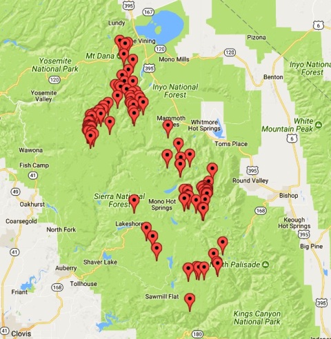
    The following hike-in lakes have been stocked in recent years with golden trout by the Department of Fish and Game's flying tanker: Apollo Lake, Aweetasal Lake, Bearpaw Lake, Beartrap Lake, Big Bear Lake, Bighorn Lake, Black Bear Lake, Brown Bear Lake, Chapel Lake, Claw Lake, Coronet Lake, Den Lake, Hooper Lake, Island Lake, Neil Lake, Upper Nelson Lake, Orchid Lake, Pemmican Lake, Rose Lake, Rosebud Lake, Silver Pass Lake, Spearpoint Lake, Teddy Bear Lake, Three Island Lake, Toe Lake, Tooth Lake, Ursa Lake, Vee Lake, Virginia Lake, and White Bear Lake.

    Meanwhile, the following lakes have been on the DFG's list for stocking with rainbow trout and brook trout in recent years: Anne Lake, Chimney Lake, Cirque Lake, Coyote Lake, Crown Lake, Davis Lake, Geraldine Lakes, Maxon Lake, Minnie Lake, Pearl Lake, Rainbow Lake, Scepter Lake, and Vermilion Lake. This list is constantly changing; check with the DFG for current status of stocked locations.

    Facilities, fees: A paved boat ramp is located on the west shore; Kaiser Pass Road leads directly to it. Lodging, tent cabins, restrooms, showers, a convenience store, flush toilets, a primitive boat ramp, fishing-boat and canoe rentals, bait and tackle, and a hiker's water taxi are at Vermillion Valley Resort. A campground with drinking water and vault toilets is nearby. Fishing access is free.

    Directions: From the town of Shaver Lake, drive north on Highway 168 for 21 miles to Kaiser Pass Road/Forest Road 80. Turn right and drive 16 (narrow and twisting) miles to a fork in the road. Bear left onto Edison Lake Road and drive approximately six miles to the resort, at the end of the road.

    Contact: Sierra National Forest, High Sierra Ranger District, 559/855-5360, fax 559/8555375; Vermilion Valley Resort, 559-2594000 (summer) or 619/668-8711 (winter), website: www.edisonlake.com.


    Kirman Lake
    near Bridgeport
    Kirman Lake
    Kirman Lake #5 Big Trout
    #5 Big Trout
    Kirman Lake #5 Fly-Fishing Trout
    #5 Fly-Fishing Trout

    Once all but unknown, little Kirman Lake has become renowned as a unique and quality fishery. It is the best brook-trout lake in the state. Brookies weighing three pounds are relatively common, especially near the end of the season in October, with a seven-pound brookie being documented. Cutthroat trout of over five pounds also inhabit the lake. The hike in to Kirman used to keep most people out, but now fly fishers have discovered it en masse, and you can see them daily, hiking in with float tubes. You get an intimate setting, specialized angling, and large cutthroat trout at little Kirman Lake. Some people feel this is a fly fisher's paradise. The trail in is 2.75 miles, including an easy hop over a fence, and that stops some anglers from bringing much gear. But this is where a light float tube or a small raft is essential for the best access and for being able to reach the key areas outside the shallows. The best area is on the left side of the lake near the beaver dams. By shore, it is very difficult to have much success.

    The rules mandate special restrictions (always check the Department of Fish and Game rule book before fishing anywhere), including mandatory use of lures or flies with a barbless hook. You should release what you catch to insure a trophy fishery here.

    The best fly patterns are shrimp patterns, based on the food supply in the lake. But many fly fishers catch the big trout on leeches, Zug Bugs, Scuds, and Matukas. The best lure is the one-sixteenth-ounce Panther Martin, black body with yellow spots, of course, rigged with a single, barbless hook. Another pattern that works great is a one-sixteenth-ounce Daredevil that has one side painted flat black, then has five small red dots on it. This was developed by Ed Dunckel, and we appropriately call it "The Mr. Dunckel Special." But remember that from shore, this is an extremely difficult lake to reach the fish.

    An average day here is to catch one of these cutthroats, maybe a brook trout too. But among those fish is the chance for a 20-incher.

    Facilities, fees: No facilities are on-site. Campgrounds are nearby. Supplies can be obtained in Bridgeport. Access is free.

    Directions: From Bridgeport, drive 17 miles northwest on U.S. 395 to its intersection with Highway 108. Turn west on Highway 108 and drive about .5 mile. Parking is past the cattle guard on the road. From the parking area, walk the 2.75-mile trail to the lake (note that there's only one hill).

    Contact: Ken's Sporting Goods, Bridgeport, 760/932-7707; The Trout Fly, 760/934-2517; Rich & Sal's Sporting Goods, Pinecrest, 209/965-3637.


    Klamath River
    near Orleans in Six Rivers National Forest
    Klamath River
    Klamath River #3 Steelhead
    #3 Steelhead

    The Klamath is one place where nature's artwork often seems perfect. This river tumbles around boulders and into gorges, and then flattens into slicks. All of the river is framed by a high, tree-lined canyon rim and an azure sky.

    Abundant wildlife and easy access to prime fishing spots make the central Klamath one of California's best fishing rivers. The steelhead start arriving in August and keep on arriving all the way through April, although the peak period is from mid-September through early November. The Klamath has one of the longest steelhead runs in America: It spans nine months and is ideal for shoreliners or guides with drift-boats and jet boats.

    The best bites occur in the fall, before the water temperature drops below 46°F. The steel-head and the half-pounders (juvenile steelhead in the 12- to 18-inch class) are most active when the water temperature is 52-58°F; they strike flies, Glo Bugs, Brindlebugs, Silver Hiltons, and night crawlers. When the water temperature drops below 46°F, the steelhead stop hitting flies, and their grabs on night crawlers become a lot more subtle.

    A key to the mid-Klamath's appeal consists of its many premium shoreline fishing spots. All you have to do is cruise Highway 96; when you spot heads of riffles, tail-outs, and deep bends, stop and make a few casts. In a day of hitting and moving, you can fish almost as many spots as if you were using a driftboat. Many pullouts along Highway 96 (a winding, two-lane road), connect to short trails that lead down to the river. My favorite spots are at the mouth of the Shasta River, the mouth of the Scott River, along a five-mile stretch through Seiad Valley just upstream from the town of Happy Camp, and from T Bar on downstream to Somes Bar.

    This area is the heart of steelhead fishing on the Klamath River in October, November, and December. You can expect that there will be good numbers of steelhead in this stretch of river. Access is excellent.

    Because the Klamath has a tendency to muddy up quickly during a winter storm, not many people target it for winter steelhead fishing. However, when the weather holds off, some of the best winter steelhead fishing can occur in this section of the Klamath.

    Most of the steelhead on the Klamath are not as large as those on the Smith River, but they are available in good numbers. Klamath steelhead are generally in the 'two- to six-pound class. The average fish is about 20 to 21 inches. On a good day you might catch a dozen half-pounders, with a possible pair of three- to four-pounders in the mix and a chance at one bigger, perhaps weighing five or six pounds. A lot of anglers do not realize that the steel-head hold in different areas on the Klamath according to time of day.

    Even though the Klamath's clarity is typically poor—which helps hide anglers—the bite can shut off during midday if bright sunlight and hot weather are present. Under such conditions, it is vital to fish in shaded areas and be on the water at both dawn and dusk.

    One trick I learned from guide Dale Lackey was never to fish an area where the fish are looking upstream into the sun. The fish simply will not hold in large numbers in these areas, and the few that do tend not to bite.

    Yet these same riffles can hold large numbers of fish at dawn or dusk. One of my favorite techniques here is to fish not only the riffles and tail-outs that look like good steelhead water, but to also fish the shoreline edges—always on the shaded side of the river and avoiding water where there is direct sunlight.

    One year I rafted the entire river (at flood stage), from its headwaters in Oregon all the way to the Pacific Ocean. This waterway is vibrant with life—not only fish, but many species of birds and other wildlife.

    • Facilities, fees: Several Forest Service campgrounds are located along Highway 96. Lodging is available at Sandy Bar Ranch in Orleans, 530/627-3379; Marble Mountain Ranch, Somes Bar, 530/469-3322 or 800/552-6284. Supplies can be obtained in the towns of Klamath River, Weitchpec, Somes Bar, Happy Camp, Seiad Valley, Horse Creek, and Orleans. Fishing access is free.

    • Directions: From Eureka, drive north on U.S. 101 past Arcata to Highway 299. Turn east on Highway 299 and drive 42 miles to Highway 96. Turn left (north) and drive 40 miles to the town of Orleans. Continue northeast on Highway 96, which runs parallel to the river. Direct river access is available off turnouts along Highway 96, as well as from short spur roads that lead to the river.

    • Contact: Orleans Ranger District, 530/6273291, fax 530/627-3401. For fishing information: Somes Bar General Store, 530/469-3350. For fishing guides: Wally Johnson, Seiad Valley, 530/496-3291; Klamath River Outfitters, 800/748-3735; Bob Bearding, Somes Bar, 530/469-3307; Ron Lantonin, Happy Camp, 530/493-2214.


    Klamath River
    near the town of Klamath and Redwood National Park
    Klamath River
    Klamath River #6 Chinook/King Salmon
    #6 Chinook/King Salmon

    On Labor Day the Lower Klamath River looks like the salmon capital of the western world. Maybe it is. The annual fall salmon run on the Lower Klamath peaks in September, and the river is lined elbow-to-elbow with wading anglers casting spinners or bait, sitting in oared driftboats or high-powered jet sleds. Every campground—public and private—will be full or close to it; the same goes for lodges and hotels. From all the hoopla, you'd probably figure that everybody is catching huge salmon, right? Well, the reality is that the catch rates are only fair, especially for shore-liners, although a few know-hows have learned how to get an edge on the masses.

    The best fishing is occasionally upstream from the mouth, both at Terwer Riffle and farther upstream at the mouth of Blue Creek. Other popular spots are at Glen, Waukell, Blake, and Johnson's Riffles and at the mouth of the Trinity River. Most of the salmon here are in the 10-pound class, and a few range to 20 pounds. It is very rare to find larger salmon on the Klamath.

    The season begins with a run of "springers," that is, salmon that arrive in late May and June. These salmon are quick-moving fish, and it is difficult to intercept them, but it can be done. The fall-run salmon begin arriving, by mid-July, and most people try to catch them in the tidal zone. The salmon run peaks in the Lower Klamath between mid-August and mid-September. Afterward, the fish head upstream. (For details, trace the Klamath River using this book's maps.) ,

    By September, half-pounders begin to arrive at the mouth and head upstream. Half-pounders are actually juvenile steelhead ranging in size from 12 to 18 inches. They often arrive in big schools and can provide exciting fishing.

    The key to the future success of this river is the number of fish that return to swim upstream and spawn. Because of the high numbers of salmon caught by commercial fishers and in Indian gill nets, the salmon population has suffered. Meanwhile, sport anglers pay the freight and have their seasons and limits reduced, despite the fact that they take less than 10 percent of the overall catch. Anglers hope that a Klamath River Power Troika—a committee made up of commercial, Native American, and sporting interests—can agree on harvest quotas and an equitable split that would ensure that the salmon return to this stream in large numbers. The habitat is in place. The Klamath River is capable of supporting runs of more than 100,000 salmon every fall. With proper management techniques, salmon could return in those numbers again. If so, all those people out on Labor Day weekend will do more than just cast into the light fall breeze. They will have a realistic chance of catching a salmon, the king of the Klamath, and the excellence of this once-great river will be reclaimed.

    Facilities, fees: Several motels, public campgrounds, private campgrounds, and RV parks are available. Steelhead Lodge offers RV spaces, a motel, a restaurant, and a bar, 707/482-8145. Redwood Rest is a popular privately owned RV park, 707/482-5033. Fishing access is free.

    Directions: From Eureka, drive north on U.S. 101 to Klamath and the junction with Highway 169. Turn east on Highway 169 and drive 3.2 miles to Terwer Riffle Road. Turn right (south) on Terwer Riffle Road and drive one block to Steelhead Lodge and access to the Klamath River. Additional river access is available along Highway 169.

    Contact: Klamath National Forest, Orleans Ranger District, 530/627-3291; Happy Camp Ranger District, 530/493-2243.

    Guides and outfitters: Gary Farley, Klamath, 707/482-5093; Wolfe's Guide Service, Alton, 707/725-1955; Somes Bar Store, 530/493-2243; Klamath River Outfitters, 530/469-3349 or 800/748-3735, website: www.klamathriver outfitters.com.


    Lake Amador
    northeast of Stockton
    Lake Amador
    Lake Amador #7 Bluegill, Sunfish, Perch and Crappie
    #7 Bluegill, Sunfish, Perch and Crappie
    Lake Amador #7 White Catfish
    #7 White Catfish
    Lake Amador #10 Trout
    #10 Trout

    Imagine a fish factory that turned out giant bass and trout in numbers as if they were being made on an assembly line. At times, Lake Amador is like that fictional fish factory.

    Amador is set in the foothill country east of Stockton at an elevation of 485 feet, covering 425 acres and with 13.5 miles of shoreline. The lake is perfect for fishing, with several extended coves—the Carson Creek arm, Cat Cove, Big Bay, the Jackson Creek arm, Rock Creek Cove, and Mountain Springs—and a law that prohibits waterskiing and personal watercraft. The top spots are the Carson Creek arm and the Jackson Creek arm.

    Lake Amador is famous for producing giant largemouth bass. In late March, it seems more bass weighing between 5 to 12 pounds are caught here than at any lake in Northern California. In summer, some of the largest bass are caught at night. Bass-fishing instructor Larry Hemphill hooks lots of big bass here on summer nights using Weapon or Rod-Strainer jigs, or 10-inch plastic worms.

    So that means everybody is fishing for the big bass, right? Wrong. The catch rates for rainbow trout have become so good from late winter through early summer that now the trout attract most of the fishing pressure. Lake Amador runs its own hatchery, which stocks thousands of pounds of trout; planting usually begins about the middle of October. These fast-growing trout are bred from wild rainbows in Summit Lake, Washington, and can reach up to 10 pounds in 16 months. The Department of Fish and Game also supplements the lake with rainbow trout in the 10- to 12-inch class. The best fishing is in the launch ramp cove (where the trout are planted), using Power Bait or small Kastmasters. Trolleys can do okay in late spring out on the main lake and near the mouth of Jackson Creek.

    One of the problems with Lake Amador in winter and early spring is that the lake muddies up easily with rain. That is why bait anglers off the bank can do better than the boat anglers trolling lures.

    A trick here is trolling a Flatfish or Apex with at least 100 feet of line out, and then making S turns. Don't hurry to put any weight in front of these lures. You want them to go as shallow as possible. The trout are right up near the surface. Bright colors are best.

    In the spring, the best bet for landing one of the big bass is using live crawdads for bait on the Jackson Creek, Mountain Springs, or Carson Creek arms of the lake. If you can't get crawdads, casting plastic worms right along the shoreline may also work. The skill and light touch required for both of these techniques can take a lot of time to develop, however. That is why the trout fishing has become so popular at Amador. With weekly stocks, it takes no time at all to figure out how to do it.

    The lake is open year-round, and it is the trout fishing that provides the best hopes. As the weather warms, there are days when everyone on the lake limits. The Jackson Creek area is my favorite spot for trout.

    The only time this lake frustrates is in late summer, when week after week of warm temperatures put the trout deep and make the bass wary. That is when a number of people switch to catfish in Big Bay and Cat Cove. Giant catfish over 40 pounds are also a very real possibility here in the spring and summer. The Mountain Springs and Carson Creek arms, as well as the dam, are the most productive spots for cat hunters using mackerel, sardines, or liver—though trout anglers soaking Power Bait near the launch ramp also get surprised by a big cat now and again. Crappie and bluegill fishing is another good prospect at Amador; fish the brushy coves with small jigs, minnows, or red worms. Add it all up, and you just about do have a fish factory.

    Facilities, fees: A small marina rents fishing boats. Campgrounds, a picnic area, drinking water, restrooms, showers, an RV dump station, fishing supplies (including bait and tackle), a snack bar, a convenience store, propane gas, a swimming pond, a boat ramp, and a playground are available. There is an entrance fee per vehicle for two people, plus more for each additional person. A fishing fee is charged per person per day, and a launch fee is charged

    Directions: From Stockton, turn east on Highway 88 and drive 24 miles to Clements. Just east of Clements, bear left on Highway 88 and drive 11 miles to Jackson Valley Road. Turn right (well signed) and drive four miles to Lake Amador Drive. Turn right and drive over the dam to the campground office.

    Contact: Lake Amador Recreation Area, 209/274-4739, website: www.lakeamador.com.


    Lake Barrett
    near Tecate, east of San Diego
    Lake Barrett
    Lake Barrett #1 Largemouth Bass
    #1 Largemouth Bass

    Imagine a godsend of a lake loaded with bass, bullhead, bluegill, and black and white crappie—but that the lake had been closed to the public for 26 years. Then imagine being selected by lottery to fish there and catching dozens of fish—unlike anything you have ever experienced. Yes, Barrett Lake is one of the rare treasures where this is possible. I rank it as the No. 1 bass and bluegill lake in California, and it has earned national fame as a unique and outstanding fishery for northern-strain largemouth bass.

    Set in a remote valley near the California/Mexico border, Barrett Lake was closed to the public starting in 1969, it then reopened in the summer of 1994 with a genius-level fishing program. Talented anglers on good days have caught more than 100 bass. Even in slow periods, the average catch is 10 bass per day.

    You can go to the best reservoirs in Mexico or sneak into the vaunted lakes of Cuba and not have a better experience. Under the reservation system, Barrett continues to have the highest bass catch rates of any lake ever documented, and because the number of anglers is controlled, it is a far more enjoyable experience than at crowded areas and the high quality of the fishery is maintained.

    When you arrive, you will discover a beautiful, 811-acre lake set in a remote valley. Except for one gated road, which crosses private property, there is no public access. Access will be permitted as long as there is no abuse of private property, such as littering, trespassing, or petty damage. If you witness any wrongdoing, immediately try to correct the situation, or the rare, wondrous chance to fish Barrett Lake will again be taken away.

    Along with Upper Otay Lake, this is one of only two reservoirs in the region operating under highly restrictive rules. One of the reasons for this is to protect the last significant local population of northern-strain largemouth black bass. The Florida-strain bass has replaced these fish in nearly all of Southern California. Other species include bullhead and black and white crappie.

    The lake is set in chaparral-covered hills. It offers good fishing structure, including rock piles, sunken timber and brush, and drop-offs—and the result is that you can catch bass regardless of your preferred style. For instance, submerged rock piles are available for those who like trying for monster-sized bass using pig-and-jig or plastic worms. There are plenty of sunken brush piles for those who like casting spinner baits. And there are also plenty of coves with midwater fish for anglers who prefer throwing crankbaits. Got it? You can do just about anything you want.... Just about. Fishing is catch-and-release, with barbless artificial hooks only. All parties must be escorted to and from the lake.

    Access is controlled through a reservation system (see Contact), and special fishing rules. In addition, threadfin shad and silverside minnows have been planted for forage. They are reproducing successfully, resulting in healthier and bigger bass. The only problem has been the lake level, which is not always full to the brim. In the fall of 2003, it was only 19 percent full. Barrett Lake is open Saturday and Sunday from April through September; in April, the lake is also open on Wednesday.

    Note: You cannot see the lake from the road. Also, all fish must be released. Artificials with barbless hooks are required.

    Facilities, fees: Rental boats with four-horsepower motors are provided. Visitors are allowed to bring their own outboard motors (up to 25 horsepower). Vault toilets are available, but drinking water is not. Garbage must be packed out. No glass containers or pets are permitted. No more than two vehicles per group and no more than 100 persons per day are let in, and RVs are not permitted. Access is by reservation only through Ticketmaster. A fishing package fee (boat rental included) is charged. Arrangements for lake escort are made after reservations are complete.

    Directions: From San Diego, take 1-8 east about 30 miles to Japutal Road. Turn south (right) on Japutal Road and drive 5.6 miles to Lyons Valley Road. Bear left on Lyons Valley Road and drive six miles Oust past milepost 12) to Barrett Lake Road and an unsigned entrance gate. A ranger will be waiting to check your entrance pass. The lake is approximately 2.5 miles beyond the gate.

    Contact: San Diego City Lakes, 619/465-3474 (recorded message) or 619/668-2050, website: www.sandiego.gov/water/recreation.

    Fishing reservations: Ticketmaster, 619/220- TIXS (619/220-8497).

    Electric-motor rentals: Stoney's Marine, El Cajon, 619/449-9459.


    Lake Berryessa
    north of Vallejo
    Lake Berryessa
    Lake Berryessa #4 Bluegill, Sunfish, Perch and Crappie
    #4 Bluegill, Sunfish, Perch and Crappie
    Lake Berryessa #4 White Catfish
    #4 White Catfish

    A trophy-trout fishery, scads of bass, and 750 campsites at seven resort areas make Lake Berryessa the Bay Area's most popular vacationland. When full, it is a big lake, covering some 21,000 acres with 165 miles of shoreline, complete with secret coves, islands, and an expanse of untouched shore (on the eastern side) that's off-limits to people.

    What you get is quality fishing. If you can visit during the week and thus avoid the party goers, you will get a chance to enjoy quiet water and good fishing. Come to Berryessa on a Thursday morning, for instance, after seeing the place on a Saturday afternoon, and you'll feel as if you're on a different planet.

    As at many large reservoirs, your approach to fishing here is dependent upon water temperature. If you want numbers, try the springtime, when the bass move in along shoreline cove areas in the lake arms. The prime areas are the three major lake arms at the south end of the lake, as well as the Putah Creek arm at the north end of the lake. Avoid the main lake body.

    The main lake along the east shore is also good for bass, especially in the spring, using Zoom flukes and Senko worms (often best in root-beer color or motor oil), or with flukes (in white).

    A fun trip is to get up before dawn, head up to the Putah Creek arm, and cast spinner-baits for smallmouth bass. Then once direct sunlight hits the water, head back to the main lake body and work over the eastern shore for largemouth bass. The east shoreline, from the vineyards on into the adjacent cove, is an excellent spot, where bass hold from late March through early June.

    Lake Berryessa seems loaded in the spring with bass ranging from 11 to 14 inches. There ,ire some giant bass in this lake. Though Clear Lake is something of a landmark for giant bass, there are giant bass just as big at Berryessa, some in the 15-pound class, though they prove to be extremely elusive. But don't be surprised if you hear of a 20-pound bass at Berryessa, because the lake has the aquatic riches to support large fish.

    In the fall and midsummer, bass can become more difficult to catch at Berryessa, especially when you have to compete with heavy water-skier traffic. Sometimes you can catch them with unusual methods that don't work the rest of the year. Believe it or not, a Blue Fox minnow spinner cast along the backs of coves in the fall is a surprising way to take bass in the 14- to 17-inch class. Done it many times.

    In the spring, as the surface water temperatures approach the mid-60s, Berryessa can be terrific for surface fishing for bass. This lake has dozens and dozens of flooded islands that bass congregate on during these times, and bass will come from 8 and 10 feet deep to hit the surface lure. Zara Spook, Pop-R, and Rico's can be very successful.

    Try two different methods, one keeping the lure moving from the time it hits the water, and the other letting it sit and then moving it slowly back towards the boat. Even old-fashioned lures like the Jitterbug can work well here. A secret is to add a small plastic worm on the rear hook, or even a skirt.

    It is common to catch 20 or 30 bass in a day, casting a variety of lures—plastics are best—along these protected shoreline coves. During the evening, surface lures such as the Rebel Pop-R can provide some exciting fishing. Most of the bass are small, many in the 10- to 12-inch class, but there are enough bigger ones to keep things interesting. Berryessa boasts nowhere near the numbers of large bass as Clear Lake to the north does, however (although the Putah Creek arm has a good supply of smallmouth).

    Trout fishing in the summer is often excellent for people who understand how to troll deep in the thermocline. The lake has a trophy trout fishery. A lot of the trout range 14 to 17 inches, and what most anglers do is get up before dawn in summer and then troll out at

    the southern areas of the lake. Portuguese Cove, Skiers Cove, both entrances to the Narrows (especially the Rock Slide, on the east side of the Lakeshore), and the mouth of Markley Cove are all good spots. The key in the summer is depth, trolling typically 25 to 35 feet deep, using lures such as the Rainbow Runners, Triple Teaser (white with a red head), and Humdinger.

    Once the hot weather arrives, it's as if the trout are locked in jail, the way they stay about 35 to 40 feet down in the thermocline. You either go that deep or get skunked. A red Rainbow Runner spoon is the preferred entreaty to catch trout in the 12- to 18-inch class. Using a downrigger is the ideal way to reach the precise depth. If you don't have a downrigger, leadcore trolling line and planer-divers will also help you get deep.

    If you don't like trolling deep, wait until the lake "turns over," that is, when the stratified temperature zones do a flip-flop, bringing cool water and trout to the surface. This usually occurs around the third week of October, and the lake surface becomes dotted with thousands of tiny pools from rising trout—a spectacular scene—best viewed on Hope Creek, Putah Creek, the Markley Cove arm, mouth of Skier's Cove, the Rock Slide at the mouth of the Narrows, and around the Big Island. The lake-record rainbow trout, 38 inches and 14 pounds, was taken during such a period. Using live minnows for bait is very effective at this time.

    When the lake turns over is when live minnow fishing can provide a fantastic sport. Use a No. 4 or 6 hook, hook the minnow through the nose vertically, then clamp a very small split shot 18 inches above that; place a bobber four to five feet above the minnow. From a boat, toss it out, then drift along the likely coves and shoreline points, letting breeze push your boat along. The minnow will swim along with you for the ride. It's best to hook the minnow through the nose because even if it dies, the action of the drift will make it appear to be swimming. Some people prefer hooking the minnows through the back, but they tend not to last as long, though they may be very active for a few minutes.

    One technique is to drift in a cove with live minnows out for bait, and as you push along the shoreline, to simultaneously cast bass lures along the shore. That way you have a chance for bass and trout on a single drift. The two-rod stamp makes this possible.

    In addition, in the fall, keep your eyes trained to scan the surface for any activity of swirling minnows. Often you can see them swirling or "boiling" and then cast to the fish. Berryessa also attracts a lot of aquatic birds called grebes, and concentrations of grebes usually indicate lots of minnows. Birds never lie.

    The Department of Fish and Game now operates a rearing project at Lake Berryessa, where small rainbow trout are grown in pens until they reach a large size and are released.

    During the winter months, shore anglers can be very productive when fishing for trout in areas like Spanish Flat and Markley Cove. Bait anglers use either a minnow under a bobber, or Power Bait and a night crawler (on separate hooks) off the bottom, and then cast a second rod with lures such as a Kastmaster, Krocodile, or Little Cleo. Be sure to have your California two-rod stamp when doing this.

    Catfish have become a more popular fish at Lake Berryessa from spring through fall. Anglers using a variety of baits (such as clams, chicken livers, and night crawlers) catch them from shore, sometimes even in the middle of the day. These fish average two pounds, but can easily go over five pounds.

    The Department of Fish and Game has an ambitious plan to turn the lake into a fish and wildlife paradise. If fulfilled, true greatness will be attained. The DFG stocks Lake Berryessa with 58,000 foot-long rainbow trout and 58,000 foot-long Eagle Lake trout annually. Berryessa is also stocked with king salmon. The DFG requests that all salmon under 14 inches be released.

    Sound good? Well, it is. However, that's the source of the lake's one problem: too many people on weekends. It is particularly frustrating when you cross paths with self-obsessed water-skiers ripping up and down the lake during the summer, with little regard for anything but themselves. The campgrounds can get loaded, too. In other words, hardly a pristine experience.

    Facilities, fees: Several campgrounds, full-service marinas, boat ramps and rentals, lodging, gas, bait, tackle, and groceries are available. There are several accessible boat ramps at Berryessa. Details on resort facilities are provided under Directions.

    Directions: From Sacramento, take 1-80 east to Davis and the exit for Highway 113. Take that exit and drive north on Highway 116 to Covell Boulevard. Turn west on Covell Boulevard and drive to Winters (where the road becomes Highway 128), and then continue up Putah Creek and past Monticello Dam.

    From the Bay Area, take 1-80 east to Cordelia Rd the exit for Suisun Valley Road. Take that exit, turn north and drive 17 miles to Highway 121. Turn right on Highway 121 and drive seven miles to Moskowite Corners and the junction of Highway 128. See access directions for specific boat ramps, marinas and resorts.

    The following are directions to specific resorts.

    • To Putah Creek Resort: From Vallejo, drive north on 1-80 to the Suisun Valley Road exit. Take Suisun Valley Road and drive north to Highway 121. Turn north on Highway 121 And drive five miles to Highway 128. Turn left on Highway 128, drive five miles to Berryessa-Knoxville Road, and continue 13 miles to 7600 Knoxville Road. A paved boat ramp, marina, motel, restaurant, bar, campground, restrooms, showers, coin laundry, and convenience store are available.

    • To Rancho Monticello Resort: From Vallejo, drive north on 1-80 to the Suisun Valley Road exit. Take Suisun Valley Road and drive north to Highway 121. Turn north on High-\% ay 121 and drive five miles to Highway 128. 1 Turn left on Highway 128, drive five miles to Berryessa-Knoxville Road. Turn right, and drive 12.5 miles to 5800 Knoxville Road. A paved boat ramp, boat rentals, full-service marina, gas, campground with restrooms and showers, coin laundry, convenience store, and snack bar are available.
    • To Lake Berryessa Marina Resort: From Vallejo, drive north on 1-80 to the Suisun Valley Road exit. Take Suisun Valley Road and drive north to Highway 121. Turn north on Highway 121 and drive five miles to Highway 128. Turn left on Highway 128, drive five miles to Berryessa-Knoxville Road, turn right, and continue nine miles to 5800 Knoxville Road. A saved boat ramp, full-service marina, houseboat and boat rentals, cabins, campground, flush toilets, showers, RV dump station, coin laundry, snack bar, RV supplies, and convenience store are available.
    • To Spanish Flat Resort: From Vallejo, drive north on 1-80 to the Suisun Valley Road exit. Take Suisun Valley Road and drive north to Highway 121. Turn north on Highway 121 and drive five miles to Highway 128. Turn north on Highway 128 and drive five miles to Berryessa-Knoxville Road. Turn right on Berryessa-Knoxville Road and continue four miles to 4290 Knoxville Road. A paved boat ramp, full-service marina, boat rentals, park-model cabins, campground, restrooms, drinking water, flush toilets, showers, and convenience store are available. A deli and grill is open on summer weekends. Coin laundry, a restaurant, and RV supplies are within 1.5 miles.
    • To Steele Park Resort: From Vallejo, drive north on 1-80 about 10 miles to the Suisun Valley Road exit. Take Suisun Valley Road and drive north another 10 miles to Highway 121. Turn north right on Highway 121 and drive about eight miles to the end of Highway 121 and the junction with Highway 128. Turn left (west) on Highway 128 and drive a short distance to Steele Canyon Road. Turn right and drive miles to the resort. A paved boat ramp, full-service marina, gas, covered and open berths, dry storage, boat rentals, a water skiing school, an RV park, a motel, cottages, two restaurants, a bar, a convenience store, and a picnic area are available.
    • To Pleasure Cove Resort: From Vallejo, drive north on I-80 about 10 miles to the Suisun Valley Road exit. Take Suisun Valley Road and drive north another 10 miles to Highway 121. Turn north right on Highway 121 and drive about eight miles to the end of Highway 121 and the junction with Highway 128. Bear right (southeast) on Highway 128 and proceed four miles to Wragg Canyon Road. Turn left and continue three miles to the resort entrance at the end of the road. A paved boat ramp, full-service manna, boat rentals, gas, park-model cabins, campground, restrooms, showers, ice, a restaurant, a bar, bait and tackle, propane gas, an RV dump station, and a convenience store are available.
    • To Markley Cove Resort: From Vallejo, drive north on I-80 about 10 miles to the Suisun Valley Road exit. Take Suisun Valley Road and drive north another 10 mile's to Highway 121. Turn north right on Highway 121 and drive about eight miles to the end of Highway 121 and the junction with Highway 128. Bear right (southeast) on Highway 128 and drive eight miles to the resort on the left. A paved boat ramp, a marina, gas, a pumphouse, boat rentals, houseboat moorings, bait, a convenience store, and a snack bar are available. Fishing access is free.
    • Contact: Napa Chamber of Commerce, 707/2267455, website: www.napachamber.com; U.S. Bureau of Reclamation, Lake Berryessa, 707/966-2111.
    • Lodging: Putah Creek Resort (north end of lake), 707/966-2116; Steele Park Resort, 707/9662123 or 800/522-2123, website: www.steelepark.com; Rancho Monticello Resort, 707/966-2188 or 707/966-9803; Lake Berryessa Marina Resort, 707/966-2161, website: www.lakeberryessa.com; Spanish Flat Resort, 707/966-7700, marina 707/966- 7708, website: www.spanishflatresort.com; Pleasure Cove Resort, 707/966-2172; Markley Cove Resort, 707/966-2134.
    • Tent and RV camping: Rancho Monticello Resort, 707/966-2188; Lake Berryessa Marina Resort, 707/966-2161; Pleasure Cove Resort, 707/966-2172.
    • Boat rentals: Markley Cove Marina (south end of lake), 707/966-2134.
    • Houseboat rentals: Lake Berryessa Houseboat Rentals, 707/966-2827.
    • Guides: Jim Munk Fishing Guide & Instruction, 707/987-3734; Larry Hemphill Guide & Instruction, 530/674-0276.


    Lake Cuyamaca
    northeast of San Diego near Cuyamaca Rancho State Park
    Lake Cuyamaca
    Lake Cuyamaca #3 Bluegill, Sunfish, Perch and Crappie
    #3 Bluegill, Sunfish, Perch and Crappie
    Lake Cuyamaca #3 White Catfish
    #3 White Catfish

    This lake is just far enough away from the San Diego area to make a trip here something special, and anglers are usually rewarded appropriately. The fishing is usually best here during the last three hours of daylight, depending on the phase of the moon.

    Lake Cuyamaca is set at 4,620 feet on the eastern slopes of the Cuyamaca Mountains. It provides solid prospects for a number of species, with good trout fishing in the cool months, good bass and crappie fishing in the spring and summer, and also prospects for catfish (which are stocked) and bluegill in summer and fall. It is one of the best-improved bass lakes in California.

    The lake often has outstanding bass fishing, as well as excellent trout fishing in the winter. The lake also has small mouth bass, channel catfish, crappie, blue catfish, bluegill, and sturgeon (more about that later).

    By early summer, the bass and crappie take over. Cuyamaca has plenty of large bass, as well as high numbers in the two- and three-pound class.

    Following are some lake records: largemouth bass, 14 pounds, three ounces; trout, 14 pounds, one ounce; channel catfish, 28 pounds, five ounces; crappie, 2 pounds, eight ounces; bluegill, 1 pound, six ounces.

    A bonus here is a 10 mph speed limit, which makes the lake ideal for boaters sneaking up on quiet coves to cast surface lures along the shoreline. Water temperatures are always key here.

    Most of the attention in this chapter is on bass, not trout, but Cuyamaca is an exception, with the best trout fishing by far in the area. This is the only lake in San Diego County where trout are stocked year-round.

    Because it is set at a much higher elevation than the other area lakes, the water stays cooler longer. In turn, the Department of Fish and Game rewards it with consistent stocks, all joining larger holdovers from previous years; additional trout from a private hatchery are planted as well. The best spots for trout in this shallow lake are at the pumphouse and at Fletcher Island (straight across from the boat ramp; walk across the dike to get there). The lake is stocked with rainbow, brown, and California golden trout, as well as with steelhead and sturgeon. Cuyamaca is often a great choice for the boater/camper/angler. A bonus is a free fishing class that takes place at 10 A.M. every Saturday.

    Now about those sturgeon.... Right: 181 sturgeon were stocked in 1996 and 1997, and the feeling is that they will start to reach keeper size—at least 46 inches—in 2004. In any case, if you are trout fishing with a light spinning rod, eating a sandwich, and then see your rod get ripped into the lake, well, you know that Mr. Sturgie just came by for a lunch of his own. The lake is open seven days a week from 6 A.M. to sunset.

    Facilities, fees: A boat ramp is on the west shore. Fishing boats, canoes, and pedal boats are for rent (arrive by 8 A.M. on Saturdays and Sundays for fishing boats). Cabins, a campground, restrooms, drinking water, flush toilets, coin-operated showers, and an RV dump station are at the state recreation area. Free fishing classes are offered at 10 A.M. on Saturdays. A convenience store and cafe' are nearby. Supplies are available in Julian. Boats, inflatables, and rafts under 10 feet long are prohibited. Canoes, paddleboats, and Zodiac-type rafts are allowed. A youth fishing program is offered, and a fishing derby is held in September. A 10 mph speed limit is enforced. No water/body contact is allowed. Day-use, fishing, and boat-launching fees are charged

    Directions: From El Cajon, drive east on 1-8 to Highway 79 (near Descanso Junction). Turn north (left) and drive nine miles to the park entrance on the left.

    Contact: Cuyamaca Rancho State Park, 760/7650755; Lake Cuyamaca, 760/765-0515 or 877/5819904, website: www.lakecuyamaca.org.


    Lake Davis
    near Portola in Plumas National Forest
    Lake Davis
    Lake Davis #2 Trout
    #2 Trout
    Lake Davis #10 Fly-Fishing Trout
    #10 Fly-Fishing Trout

    What is occurring at Lake Davis is the resurgence of California's preeminent trout fishery at a mountain lake, with the Department of Fish and Game creating a fishery where the trout say "Catch me!"

    Davis has always been one of the best mountain trout fisheries in America because of its rich aquatic food chain. This differs from most mountain lakes, where the stark, pristine waters provide little food and the fish stay very small. The trout at Davis are often in the 14- to 20-inch class, sometimes bigger, and always beautiful and healthy, with the brightest black spots imaginable. It's a great lake for people camping or staying in the cabins, fishing from shore, trolling, fly-fishing, and float tubing. From the late spring ice-out, through June, and in the fall are the peak times to fish for trout. They span all sizes, from dinkers to 24-inch trophies.

    Lake Davis is located in the southern reaches of Plumas National Forest, just 50 miles from Reno—a bonus if you want to end your trip with a little gambling binge. It's good-sized, with 30 miles of shoreline; even so, it can freeze over. That's because it's set high in the northern Sierra, at an elevation of 5,775 feet, so it freezes over and gets plenty of snow in the winter.

    Many people just show up, pick a spot along the shore at Camp 5 and then throw out Power Bait with a very light weight, floating the bait just off the bottom. They average two or three fish and are very content with that.

    Others with boats will troll just off the island or from Camp 5 up to the mouth of Freeman Creek, trolling woolly buggers or Cripplures. The bite is excellent from April through early June, and then slows down during warm days of summer. The fishing picks up again from about the first week of September, better yet in October, and continues until snow and bad weather shut the lake down in November. Skilled trolleys can take 20 to 30 fish per trip when things are going great guns. There's a real nice spot just to the far side of the island, a slot that can be extremely productive.

    If that doesn't score, then head up toward the mouth of the creeks. Needlefish work well here, and so does the fire-tiger-colored Countdown Rapala. In fact, when the water is cool, as in the late spring and again in the fall, trolling a Rapala on a long line where the lake shallows up can result in some really big fish.

    This lake is ideal for fly-fishing from a float tube, particularly on the northwest end, near the outlets of Freeman Creek (the best spot) and Grizzly Creek (second best). In fact, the whole northwestern end seems to hold more of the larger resident trout, while the southern end has more of the smaller planters. Davis has become a favorite among float tubers. They'll spend the day fly casting with woolly worms and woolly buggers, using a strip retrieve and doing well. Ten per rod is doing well, and again, there is a good chance for 16- and 17- inchers—and bigger.

    All boating is permitted here, and trolling is quite popular. But if you arrive in the spring, beware of afternoon winds, which can howl out of the north. So dress warmly, get out early, and enjoy the quiet time. As summer arrives, the evening trout rise can be quite a sight.

    Lake Davis was incorrectly poisoned in the fall of 1997 to eradicate northern pike, a nonnative predator fish that had been introduced illegally into the lake. But just like any invasion, the good goes with the bad, and getting rid of the pike meant killing off the entire lake. The poisoning cost California anglers $2 million from their license fees. The DFG feared the pike would get downstream and eventually into the Delta, where they would threaten to wipe out salmon, steelhead, and several endangered species, such as the delta smelt.

    The biggest trout plants in history were made at Davis-900,000 in 1998—including tanker after tanker of trout in the five- to eight-pound class, and some even bigger. Big stocks are promised every year as the DFG puts Davis back on the map as a preeminent fishery.

    DFG biologists have projected that many of the trout introduced to the lake will spawn in the future, and their progeny will take on the characteristics of the previous wild-born trout that made Davis one of the special travel destinations for anglers throughout the western United States.

    Facilities, fees: Several campgrounds are available. The largest is Grasshopper Flat. Drinking water and vault toilets are provided. A boat ramp, grocery store, and an RV dump station are nearby. Supplies are at the Grizzly Store (at Lake Davis) and at Dollard's (in Portola). Fishing access is free.

    Directions: From Truckee, turn north on Highway 89 and drive to Sattley and County Road A23. Turn right on County Road A23 and drive 13 miles to Highway 70. Turn left on Highway 70 and drive one mile to Grizzly Road. Turn right on Grizzly Road and drive about six miles to Lake Davis. To Lightning Tree Campground: From Truckee, turn north on Highway 89 and drive to Sattley and County Road A23. Turn right on County Road A23 and drive 13 miles to Highway 70. Turn left on Highway 70 and drive one mile to Grizzly Road. Turn right on Grizzly Road and drive about six miles to Lake Davis. Continue north on Lake Davis Road along the lake's east shore, and drive about five miles to the campground entrance, on the left.

    Contact: Plumas National Forest, Beckwourth Ranger District, 530/836-2570; Plumas County Visitors Bureau, 800/326-2247, website: www-plumas-ca.us; Lake Davis Cabins, 530/832, 1060; Grizzly Store, Lake Davis, 530/832-0270; Dollard's, Portola, 530/832-5251; Sportsmen's Den, Quincy, 530/283-2733; Golden Eagle Guide Service, 530/836-4868; Anastasia's Fishing Guide Service, 530/832-5181; D. W.'s Fishing Advisory Service, 530/836-2166.


    Lake Hodges
    south of Escondido
    Lake Hodges
    Lake Hodges #2 Bluegill, Sunfish, Perch and Crappie
    #2 Bluegill, Sunfish, Perch and Crappie
    Lake Hodges #2 White Catfish
    #2 White Catfish
    Lake Hodges #7 Largemouth Bass
    #7 Largemouth Bass

    How you feel about Hodges all depends upon your perspective. You might feel that it's the best lake you have ever fished, where you have a better chance of catching a 10-pound bass than any other place in the United States. Or you might feel that it's the aquatic version of the San Diego Zoo: too many people, ridiculous lines at the boat ramp at dawn, and no such thing as a secret spot. Hodges encompasses both of those outlooks. It's a fantastic producer of big bass, and, in fact, it is one of the few lakes ever to produce a 20-pounder. The lake record weighed 20 pounds, four ounces. Other lake records: bluegill, 2 pounds, eight ounces; channel catfish, 35 pounds. But the place is very heavily fished and has a lot of negatives because of it.

    Lake Hodges is set at an elevation of 314 feet in the coastal foothills just west of I-15. It's a long, narrow, snakelike reservoir shaped like an inverted V. It is set on the San Diego River, spans 1,234 surface acres when full, and has 27 miles of shoreline and a maximum water depth of 115 feet. It is home to Florida-strain largemouth bass, crappie, bluegill, channel catfish, bullhead, and carp. The minimum size limit for bass is 15 inches. Since the lake is closed four days per week, the fish get a regular, needed rest.

    The bass come big at Hodges, and in the spring they are also abundant during the first few hours after an opener. There are no secret spots at Hodges; at one time or another, everybody fishes the same areas: both corners of the dam, the Bernardo arm (early in the year), the Narrows (just west of Felicita Bay), and anyplace where you see stickups. The big bass, the 10-pounders and up, tend to be 15 to 20 feet deep. The crappie fishing is excellent at times.

    Because of the amount of fishing pressure and the fact that catch-and-release is growing in popularity, the bass in Hodges are quite smart. Newcomers with little experience can have problems getting anything, particularly if they show up after 10 A.M.; by then, every good spot in the lake has already been hit. On the other hand, know-hows who get on the lake early and then fish plastic worms, spinnerbaits, and crankbaits with a delicate-enough touch to discern the most subtle bites may come up with a fish approaching the world record.

    This lake is notorious for low water levels, which can close it to boating or limit the activities (in the fall of 2003, the lake was 13 percent full). Hodges has been open for years on Wednesdays and weekends, as well as on holidays, from March through October (water levels permitting), but access days have been up for debate. The lake could be closed Wednesdays, yet open on Fridays. Check for status of water levels and access days.

    Facilities, fees: At the time of publication, the concessionaire had closed temporarily because of low water levels, and no boat rentals were available. There is a paved boat ramp, picnic area, snack bar, bait and tackle, and a wheelchair-accessible fishing float. Full facilities can be found in Escondido to the north or San Diego to the south. The speed limit is 35 mph. Fishing and boat-launching fees are charged

    Directions: From 1-15 at Escondido, turn west on Via Rancho Parkway and drive to Lake Drive. Turn left on Lake Drive and continue to the lake entrance. From the entrance, continue one mile to the boat ramp.

    Contact: San Diego City Lakes, 619/465-3474 (recorded message) or 619/668-2050, website: www.sandiego.gov/water/recreation.


    Lake Morena
    east of San Diego at Lake Morena County Park
    Lake Morena
    Lake Morena #10 Largemouth Bass
    #10 Largemouth Bass

    You want fish? You got fish. The lake is out in the boondocks, but it's worth the trip. If you like bass, make the effort.

    The key here is the elevation. The lake is set at 3,200 feet and is just south of Cleveland National Forest, only seven or eight miles from the California/Mexico border. Because of the altitude, everything gets going a little later in the season than at lakes set at lower elevations and closer to San Diego. Some folks show up in early March, find the bass deep and sluggish, and wonder "What's all the fuss about Morena?" Show up a month later, however, and you'll find out.

    From April through July, Morena consistently produces bass—small ones, big ones, and medium ones. It's just plain a fish-catching place. The lake has a lot of brush-lined shore and plenty of rocks, and the bass will hang amid these areas. Since Morena covers 1,500 surface acres when full and has 26 miles of shoreline, a boat with an electric motor will help you cover all the good spots in a single weekend. The back side of Goat Island used to be a prime spot on the lake, but due to low water levels, the back side has been dry, and there has been no Goat Island since the early 2000s.

    Before the fish move into the shallows, the fishing is best on plastic worms, salt-and-pepper-colored reapers, and eight-inch cinnamon-colored Blue Veins. Then, just like that, when the fish move into the top 5 or 10 feet of water, it's a great lake for casting surface lures. It's exciting fishing, with the strikes coming right on top. Try the Rebel Pop-R, Jitterbug, Zara Spook, floating Rapala, or Chugger. If you have a fly rod, bring it along and lay small poppers along the surface. Bass? There are plenty.

    The lake is also stocked with trout, and they provide a fair alternative. The Department of Fish and Game plunks in rainbow trout in the 7- to 8-inch class and some up to 12 inches. They are more like growing pills for bass, however, and the lake record proves it. The record bass weighed 19 pounds, three ounces. The lake record for trout is 9 pounds, six ounces. Morena also has catfish, bluegill, crappie, and redear sunfish. The lake experiences something of a drawdown over the course of a year, and by fall, it isn't unusual for it to be about two-thirds full. In fall of 2003, the lake was only nine percent full.

    If you haven't fished Lake Morena in a few years, then you may just laugh and say, "I know that lake, it's the one with all the dirks." That's right, Morena used to be loaded with small bass. But the evolution of this lake has continued onward since those days. Now there are bass of all sizes, and they are biters.

    Facilities, fees: There is a paved boat launch. Campgrounds, cabins, restrooms with flush toilets, showers, propane gas, coin laundry, and picnic areas are available. Developed facilities are at Morena Village to the east. Boats under 9 feet or over 18 feet long are prohibited. No swimming is allowed. The speed limit is 10 mph. Day-use, fishing, and boat-launching fees are charged.

    Directions: From El Cajon, drive east on 1-8 to Pine Valley, then continue east for four miles to Buckman Springs Road/County Road SI. Take the Buckman Springs off ramp, turn right (south) on Buckman Springs Road and drive 5.5 miles to Oak Drive. Turn right on Oak Drive and drive 1.5 miles to Lake Morena Drive. Turn left on Lake Morena Drive and drive to the lake (there's an RV park on the right, at 2330 Lake Morena Drive).

    Contact: Lake Morena, San Diego County Parks, 858/694-3049, website: www.sdparks.org.


    Lake Oroville
    near Oroville
    Lake Oroville Largemouth
    Lake Oroville #8 Largemouth Bass
    #8 Largemouth Bass

    Covering more than 15,000 acres, Lake Oroville is a huge reservoir with extensive lake arms and a large central body of water. Fish? It's got 'em—a wide variety, including rainbow trout, brown trout, largemouth bass, catfish, bluegill, crappie, and a significant salmon population. The DFG plants fingerling brown trout and fingerling and yearling Chinook salmon. At first glance, Oroville seems to have it all: campgrounds, enough water for all kinds of boating, and a fish for every angler.

    The bass fishery has undergone a dramatic change from a decade ago. Spotted bass are now the main bass species taken. Largemouths are still caught by anglers fishing in the coves, brush, and wood throughout the lake; small-mouths are relatively rare in the catches, but spotted bass are abundant.

    The introduction of the spotted bass has created a great winter bass fishery that didn't exist before, since the "spots" continue to be active after the water temperatures dip below 50°F, unlike their largemouth and smallmouth cousins, according to DFG fishery biologist Dennis Lee. In fact, some of the prime fishing is from December through March, when everything from spooning with Kastmasters and Hopkins spoons in deep water to tossing spinnerbaits into the mouths of rain-gorged creeks yields results at times.

    The "slot" limit, where only fish under 12 inches or over 15 inches may be kept, is largely credited with making Oroville one of the better bass lakes in the state. That is why there are more big spotted bass at Oroville than any other lake in Northern California. Also, it has the Northern California record: 14 pounds, 11 ounces.

    The bass fishing can be fantastic in the spring, the one time of year when greatness is possible. In late spring, bass anglers can experience spurts of fantastic days when everything comes together: no wind, the bass hanging out in the top five feet of water up the lake arms, and a catch of 15 or 30 fish. It is best to try for bass at high water in the spring, casting to the backs of caves. The fish often hide below floating debris and wood.

    If you're unfamiliar with the lake, one of the best areas to try for bass is the Middle Fork, especially from the mouth of the canyon up to the Bidwell Bar Bridge. Fish here from late winter into early summer, working the north shoreline along the steep rocks. How good is it? This can produce 30-fish days, with most of the bass running 12 to 14 inches and about one out of five running bigger. One of the best lures is a salt-and-pepper worm with a chartreuse tail, either four- or six-inches long and rigged on a dart head.

    Some big trout also live in this lake, and they provide good trolling results during the seasonal transitions from winter to spring and from fall to winter. The fishing is best well up the lake arms, particularly if you troll for big browns with a jointed Rapala during the cool fall months, or for small rainbow trout using the traditional flasher/night crawler combination. Most of the year, however, the surface waters get so warm that the trout stay very deep-60 to 80 feet down, sometimes even deeper—and few anglers like to fish that deep in a lake. A Scotty downrigger can solve that. For trolleys, the most common catch at Lake Oroville is Chinook salmon.

    Salmon can be found all over the lake, but there are two spots that are best. The first is by the dam, where water is pumped back into the depths of the lake in order to infuse oxygen into the cool depths. Trolling 125 feet is common near the dam. The second is about halfway up the North Fork arm; 60 feet down is usually about right here.

    You have to use your fish locator to find the schools of fish, but when you find them, rest assured they will be there for weeks at a time—and you have your very own secret spot. Try trolling Speedy Shiners, Rapalas, or Sparklefish.

    There is a chance of catching brown trout ranging over five pounds by trolling the points between the Bidwell Bar Bridge and Canyon Creek either very early in the morning or very late in the evening. Use large Rebels and Rapalas trolled on a long line anywhere from 15 to 35 feet deep.

    The Lake Oroville Fishery Enhancement Committee (LOFEC) is demanding improved management of fishery habitat, water levels, and recreation sites. Significant black-bass habitat projects have been completed. At an elevation of 900 feet in foothill country, the lake gets some very hot temperatures in the summer, and anybody who isn't prepared will shrivel like a raisin.

    The Department of Water Resources has funded recreation opportunities at this lake, and it provides some unique opportunities for camping. They include a floating barge of a campground. It's like a houseboat without a motor and is one of the best group campground deals anywhere in California. There are also floating restrooms, as well as floating platforms for tents.

    Facilities, fees: Several campgrounds, including Bidwell Canyon and Loafer Creek, are available in addition to floating platforms for camping and boat-in camping. There are rest-rooms with flush toilets, coin showers, and RV dump stations. A full-service marina, boat ramps, boat rentals, groceries, gas, bait, and tackle are nearby. Day-use fees apply, or an annual day-use permit can be purchased.

    • Directions: From Oroville, drive seven miles east on Highway 162 to Canyon Drive. Turn left and drive two miles to Oroville Dam. Turn left and drive over the dam to the spillway parking lot at the end of the road. Register at the entrance station. Boats can be launched from this area. To the State Recreation Area: From the Sacramento area, drive north on 1-5 and to the junction with Highway 99/70. Turn north on Highway 99/70 and continue on Highway 70 into Oroville to Highway 162. Turn east and drive eight miles to Kelly Ridge Road. Turn north (left) and drive 1.5 miles to Arroyo Drive. Turn right and drive to the state park entrance.

      Contact: Lake Oroville State Recreation Area, 530/538-2200, website: www.parks.ca.gov (click on Find A Park); Oroville Chamber of Commerce, 530/538-2542 or 800/655-4653; Lake Oroville Visitors Center (open weekends), 530/5382219; Bidwell Canyon Marina, 530/589-3165, website: www.gobidweU.com; Limesaddle Marina, 530/877-2414.

      Supplies: Lake Oroville Bait & Tackle, 530/5339220; Huntington's Sportsman's Store, Oroville, 530/534-8000, website: www.huntingtons.com.

      Guides: Cash Colby, 530/533-1510; Larry Hemphill, 530/674-0276; Pro Bass Guide Service, 530/533-1510; Golden State Guide Service, 530/532-1157.


    Lake Perris
    southeast of Riverside at Lake Perris State Recreation Area
    Lake Perris
    Lake Perris #6 Bluegill, Sunfish, Perch and Crappie
    #6 Bluegill, Sunfish, Perch and Crappie
    Lake Perris #6 White Catfish
    #6 White Catfish

    Legends can through newcomers off the track, and the legend of Lake Perris as one of the best lakes for spotted bass sends many anglers on their first adventure here on a wild goose chase.

    Perris dominates the line-class world records kept by the International Game Fish Association for spotted bass like no other water in the world does for any species. But the big spot-ties are not as easy to catch as you might think, and in the attempt to track down a monster, many anglers overlook outstanding surface fishing for largemouth bass and solid trout fishing. In addition, there are some truly awesome monster-sized bluegill, courtesy of the fast-growing Florida strain. They bite best in the spring.

    The lake annually produces dozens of double digit-weight bass and the current lake record largemouth bass is 17 pounds, 6 ounces. To catch the big ones here, try using big swim baits.

    The largemouth bass fishing here is often much better than that for spotted bass, world records aside. It's an ideal place to learn how to fish the surface, either casting a floating Rapala, Zara Spook, Jitterbug, or Chugg or even fly-fishing with a popper or mouse. As long as the water isn't too cold, the popping and plugging can produce excellent catch rates. In the warm months, get on the water early or late, and leave it to the water-skiers between 10:30 A.M. and 5 P.M.

    I remember one early summer morning when I first gave up on the spotted bass here and instead tried for largemouth. I caught and released nearly a dozen and figured I'd really done something special. But back at the launch ramp at 11 A.M., I learned that nearly everyone was catching 10 to 15 fish apiece, even more for some anglers. It completely changed my focus.

    The irony is that there are still a few huge spotted bass at Perris. But the truth is that the largemouth bass are taking over. The better fishing for spotted bass is not with surface lures, but with grubs, fishing them 20 to 25 feet deep. The top spots for spotties are in breaks between submerged structure that is bottomed out by rocks. It can take a lot of searching.

    What does not take a lot of searching are the trout. The Department of Fish and Game stocks large numbers of rainbow trout, in the 7- to 8-inch and 10- to 12-inch classes. In the cooler months, when the bass are sluggish, the rainbow trout provide good catch rates for both trolleys and bait dunkers. The lake also has catfish and crappie. And, unfortunately, it can have a ton of water-skiers during the summer. The weather out here can be like a fire pit in the summer and fall, and that makes waterskiing very popular.

    The lake (elevation 1,500 feet) is set in Moreno Valley just southwest of the Badlands foothills. It's a roundish lake that covers 2,200 acres, with an island that makes a good boat-in picnic site.

    Facilities, fees: A large, multi-lane paved launching area is located on the lake's north shore, just east of the marina. Campgrounds, rest-rooms with flush toilets, coin showers, an RV dump station, picnic areas, a full-service marina, moorings, two swimming beaches, a snack bar, and a convenience store are available. Fishing boats and pontoon boats are for rent. The speed limit is 35 mph, except in a few areas where it is reduced to 5 mph. A day-use fee and boating fee is charged.

    Directions: From Riverside, drive east on I215/Highway 60 for about five miles to the I215/60 split. Bear south on 1-215 at the split and drive six miles to Ramona Expressway. Turn left (east) and drive 3.5 miles to Lake Perris Drive. Turn left and drive .75 mile to the park entrance. Boat ramps are located on the north shore of the lake.

    Contact: Lake Perris State Recreation Area, 909/940-5603 or 909/657-0676; Lake Perris Marina, 909/657-2179.


    Lake San Antonio
    north of San Luis Obispo
    Lake San Antonio
    Lake San Antonio #4 Largemouth Bass
    #4 Largemouth Bass

    Can you imagine catching 100 bass in a day? At San Antonio, this vision has been no mirage. The lake has become one of the best in California for high catches of largemouth bass, with 100-fish days possible for know-hows on the water. (No trout stocks are made here.) The best bet has been for anglers in boats casting topwater crankbaits, poking along the shoreline on the lake's arms.

    Fishing is always best from March through early May. The lake has two arms on the southwest part of the lake and another on the northwest side. These are the superior spots during the spring bass bite.

    If you want striped bass, however, the timing of your trip is critical. You'd do best to show up in the fall, from late September through mid-October, when the striped bass emerge from the depths and roam near the surface, corralling schools of baitfish. Stripers can also be caught in the early summer by trolling or casting diving plugs. They can be difficult to catch the rest of the year.

    There are also good numbers of catfish, crappie, sunfish, and bluegill.

    By summer, the water-skiers take over (this is the most popular waterskiing lake in the region). In the winter, eagle tours (on the south shore) are the main attraction, and there is an excellent chance of seeing both bald and golden eagles by boat. Lake San Antonio has the largest population of bald eagles in central California. Winter is the best time to spot them.

    San Antonio is a big lake (16 miles long and covering 5,500 surface acres), but it is long and narrow, with about 60 miles of shoreline, four boat ramps, and several campgrounds. It is set at 780 feet in the dry, hilly grassland country. The average temperature in the summer is in the 70s, courtesy of the lake's location (20 miles from the coastline). If you make the trip, keep an eye out to the skies. You never know when a bald eagle might be watching.

    Facilities, fees: Campgrounds, restrooms with showers, mobile home rentals, picnic areas, a full-service marina, four paved boat ramps, mooring and slips, a snack bar, a restaurant, a gas station, coin laundry, an RV dump station, and a convenience store are available. Fishing boats, pontoon boats, ski boats, canoes, and kayaks can be rented at Lake San Antonio Marina. Day-use and boat-launch fees are charged.

    Directions: To the north shore: On U.S. 101, drive to Jolon Road/G-14 exit (just north of King City). Take that exit, turn south on Jolon Road, and drive 27 miles to Pleyto Road (a curvy road). Turn right and drive three miles to the north-shore entrance of the lake. Note: When arriving from the south or east on U.S. 101 near Paso Robles, it is faster to take G18/Jolon Road exit. To the south shore from the south: Drive on U.S. 101 to Paso Robles and the 24th Street exit (G-14 west). Take that exit and drive 14 miles to Lake Nacimiento Drive. Turn right and drive across Lake Nacimiento Dam to Interlake Road. Turn left and drive seven miles to Lake San Antonio Road. Turn right and drive three miles to the South Shore entrance. To the south shore from the north: From U.S. 101 (just north of King City), take the Jolon Road/G-14 exit. Turn south on Jolon Road and drive 20 miles to Lockwood and Interlake Road (G-14). Turn right and drive13 miles to San Antonio Lak6 Road. Turn left and drive three miles to the south-shore entrance of the lake.

    Contact: Lake San Antonio, 805/472-2311, web-site: www.co.monterey.ca.us/parks; Lake San Antonio Resort, 800/310-2313; Lake San Antonio Marina boat rentals, 805/472-2818, boat tours, 888/588-2267.

    Party boats: Morro Bay Yacht Charters, 805/441-1430, website: www.morrobayyacht charters.com.


    Lake Tahoe
    east of Sacramento in the Lake Tahoe Basin
    Lake Tahoe
    Lake Tahoe #1 Mackinaw Trout
    #1 Mackinaw Trout

    So few places evoke an emotional response at first glance. Lake Tahoe, along with Crater Lake in Oregon and the Yosemite Valley, is one of those rare natural wonders that make you feel something special just by looking at it.

    Of course, Tahoe is huge: 22 miles long, 12 miles wide, and 1,645 feet deep at its deepest point. It is filled with 39 trillion gallons of water, enough to cover California to a depth of 14 inches (hypothetically), and enough so that it would take 300 years of severe drought for it to drain significantly. It also has unmatched purity. This water is 99.9 percent pure, similar to distilled water. It is so clear that on a calm day, you can see a dinner plate 75 feet or more below the surface. That purity, however, is what prevents the lake from becoming a world-class fishery, undermining its ability to support large amounts of aquatic life. Nevertheless, it remains a quality fishery. The Mackinaw trout are the resident trophy fishery, the rainbow trout provide the most predictable results, and the kokanee salmon offer wild sprees most years during late summer.

    What I learned first about Tahoe is that the fish hold in relatively small pockets, and that 95 percent of the water has no fish at all. Newcomers arriving green are unlikely to catch anything. But once you start to figure out this lake, great things become possible.

    The Mackinaw can provide the best battle. They average 5 pounds but commonly reach 8, and are occasionally much bigger, with 10-to 25-pounders a possibility. Some say that 50-and 60-pounders swim the depths of the lake, but nobody has ever landed one. The biggest one documented is 38 pounds, the state record.

    When Mackinaws weigh more than 10 pounds, they are usually called "lakers," as in lake trout. Well, most of the lakers are taken in a few key spots: in the northwest section of the lake along the steep underwater ledge, 160 to 220 feet deep; in the southern part of the lake in the vicinity of Emerald Bay; and near underwater knobs and domes, such as the one that rises to 160 feet below the surface, about a mile offshore of Casino Row at South Shore. The water is so clear that light penetration causes the Mackinaws to live quite deep, commonly 150 feet down—and much deeper on bright, sunny days and when there's a full moon. That is why know-how anglers at Tahoe get on the water at first light, prefer overcast days, always troll deep for the lakers, and are usually done fishing by 9 or 10 A.M.

    It's a different deal, however, for rainbow trout and kokanee salmon. In good kokanee years, trolleys from Tahoe City to Homewood (on the west shore) begin to catch some fish in the early summer. The fish seem to use the west side of the lake as a migration route as they head for their spawning stream (Taylor Creek) at the south end of the lake. By August, the kokes will be camped out off the mouth of Taylor Creek and around Camp Richardson. They begin moving up the creek to spawn in early October.

    The size of kokanee varies from year to year at Lake Tahoe, usually due to the amount of plankton produced. The best fishing occurs at the south end of the lake in midsummer, from mid-July through the month of August. Fishing for kokanee is an early-morning affair, even though you can reach them in midday. Tahoe is one lake where they don't seem to bite so much after 8 A.M.

    The kokanee bite can be a wild affair, a one-after-another proposition. When does that happen? Like a long-shot romance, sometimes never. When it does, it is usually in late summer or early fall; by September, enough kokanee have either been caught or not caught to determine whether the year is a winner or a loser. The DFG plants kokanee salmon at several points around the lake on a fairly regular basis.

    Trolling for rainbow trout is decent sport at Tahoe, and it is aided by the stocking of 10- to 12-inch-class rainbow trout, a fairly sparse number though, considering the huge amount of water available. These fish avoid areas with sandy bottoms and instead congregate where rocky terrain supports more aquatic life and provides better feeding. Such spots are found along the northwestern shore near Kings Beach, and along the southeastern shore just inside the Nevada line. Every once in a while, somebody catches a monster brown trout by accident while trolling for rainbows in these areas. The browns like to eat the small trout, you see.

    The flats outside Tahoe City can be a wonder for rainbow trout. These flats cover several hundred acres with an average depth of 25 to 35 feet. Then as you head south, it drops off dramatically into several hundred feet of water. Tahoe can be a very windy lake, and therefore very dangerous for those with small boats. When the wind blows from the south at Lake Tahoe, the waves become 1.5 to 2 feet high.

    Big rainbows move up out of the depths and onto the flats to feed. Troll a speedy shiner, sparkle fish, or a Rebel or Rapala at least 4 mph with leadcore line, letting out at least 150 feet of line. If you hook three, you'll be lucky to land one; they're terrific fighters. The average size can run close to four pounds.

    Always remember that Tahoe is a special place. You may never see water so clear in the outdoors. Thus it requires a special approach, and you must be out on the water early or late in the day. What to do in between? After you've had your fill of the casinos, maybe you can sit on the ridge above Emerald Bay or take the chairlift to the top of Heavenly Valley and just look at the lake. The sight will conjure some of the greatest feelings possible.

    There is no place on Earth like Lake Tahoe. The South Lake Tahoe's Visitor Authority provided the following facts about the lake:

    • It is North America's largest alpine lake.
    • The elevation is 6,226 feet, making it the highest lake of its size in the United States.
    • With a depth of 1,645 feet (near Crystal Bay), it is the third-deepest lake in North America and the 10th-deepest in the world (Lake Baikal, in Russia, is the deepest, at over 4,600 feet). The average depth is 989 feet.
    • About 95 percent of the lake's fish live in only 5 percent of the water.
    • If drained, the lake would take 700 years to refill.
    • Sixty-three streams flow into Lake Tahoe, but only one, the Truckee River, flows out, running past Reno and into Pyramid Lake.
    • The sun shines at Lake Tahoe an average of 274 days per year, but snowfall has been recorded every month and averages 420 inches per year.
    • The water is so deep, cold (39°F below 700 feet), and devoid of light and oxygen on the bottom, that, according to legend, 1930s mobsters wearing "cement shoes" have been perfectly preserved on the lake bottom, complete with vintage clothing.

    Facilities, fees: Campgrounds, lodging, marinas, boat rentals, groceries, bait, and tackle are at several locations around the lake. Boat ramps are at the following locations.

    North Lake Tahoe:

    • Kings Beach Recreation Area: There is a paved ramp suitable for small boats. Ski boats, sailboats, and personal watercraft can be rented. It's located off Highway 28, in Kings Beach. For more information, call 530/546-4212.
    • North Tahoe Marina: The paved ramp here can only be used by special arrangement; it's closed to the public. A full-service marina with accessories and moorings are available. Powerboats are for rent. It's located on Highway 28 in Tahoe Vista. For more information, call 530/546-8248.
    • Sierra Boat Company: A full-service marina, hoist, and boat storage are available. It's located at 5146 North Lake Boulevard, in Carnelian Bay. For more information, call 530/546-2551.
    • Lake Forest Boat Ramp: A paved ramp is available. It's located on North Lake Forest Road, off Highway 28 in Lake Forest. For more information, call 530/583-3796, ext. 29.
    • Tahoe City Marina: There is a boat lift, a full-service marina, moorings, slip rentals, and boat storage. Powerboats, fishing boats, and sailboats are for rent. Parasailing, sailing charters, and fishing charters are available. It's located on Highway 28 in Tahoe City. For more information contact 530/583-1039, or go to the website: www.tahoecitymarina.com.
    • Sunnyside Marina: A marina, hoist, and boat storage are available. It's located at 1850 West Lake Boulevard (Highway 28), two miles south of Tahoe City. To contact the water-ski school, call 530/583-7417; for general information, call 530/583-7201.
    • Homewood High and Dry Marina: A hoist, a full-service marina, moorings, and boat storage are available. Powerboats, ski boats, sailboats, canoes, and kayaks are for rent. It's located on Highway 89 in Homewood. To contact the waterskiing school, call 530/583-7417; for the marina, call 530/525-5966.
    • Obexers Boat Company: A paved ramp, travel lift, boat storage, and limited marina services are available. It's located at 5355 West Lake Boulevard, in Homewood. For more information, call 530/525-7962.
    • Meeks Bay Resort and Marina: A paved ramp and full-service marina are provided. Powerboats, canoes, kayaks, and pedal boats are for rent. A chartered speedboat is available. It's located on Highway 89, 10 miles south of Tahoe City. For more information, call 530/525-5588 or; 530/525-6946.
    • Sand Harbor Ramp: A paved ramp and limited marina facilities are available. It's located on Highway 28, two miles south of Incline Village. For more information, call 775/831-0494.

    South Lake Tahoe:

    • Camp Richardson Resort and Marina: A paved ramp and a full-service marina with moorings are available. Powerboats, personal watercraft, kayaks, and pedal boats are for rent. Fishing charters, parasailing, and water-ski schools are available. It's located on Highway 89, 2.5 miles north of South Lake Tahoe. For boat rentals, call 530/541-1801 or 800/544-1801; for the marina, call 530/542-6570; or go to the general website: www.camprichardson.com.
    • Lakeside Marina: A paved ramp and a full-service marina and moorings are available. Ski boats, sport boats, and pontoon boats are for rent. It's located at the junction of Lakeshore Boulevard and Park Avenue, off Highway 50 in South Lake Tahoe. For more information, call 530/541-6626.
    • Ski Run Marina: Powerboats, personal watercraft, fishing boats, and pontoon boats are for rent. It's located at 900 Ski Run Boulevard, in South Lake Tahoe, 1.5 miles south of Stateline. For more information, call 530/544-9500.
    • South Lake Tahoe Recreation Area/El Dorado Boat Ramp: A paved ramp is available. It's located on Lakeview Avenue, off Highway 50, in South Lake Tahoe. For more information, call 530/542-6056.
    • Tahoe Keys Marina: A paved ramp, full-service marina, and fishing and sailing charters are available. Ski boats, personal watercraft, sailboats, kayaks, and canoes are for rent. It's located on Tahoe Keys Boulevard, off Highway 50. For boat rentals, call 530/544-8888; for the marina, call 530/541-2155.
    • Timber Cove Marina: An unimproved boat ramp and limited marina services and moorings are available. Ski boats, personal water-'craft, pontoon boats, sailboats, kayaks, pedal boats, and water bikes are for rent. It's located at 3411 Lake Tahoe Boulevard, in South Lake Tahoe. For more information, call 530/544-2942.
    • Zephyr Cove Marina: An unimproved ramp and full-service marina are available. It's located on Highway 50 in Zephyr Cove. Ski boats, fishing boats, personal watercraft, canoes, kayaks, pontoon boats, and pedal boats are for rent. For more information, call 775/588-3833.
    • Cave Rock Ramp: A paved ramp is available. It's located on Highway 50, three miles north of Zephyr Cove. In summer months, call 775/588-7975; in winter months, call 775/831-0494. Fishing access is free. Fees are charged for parking, boat launching, mooring, and camping.

    Directions: To North Shore/Kings Beach: From Sacramento, take 1-80 east to Truckee, and then continue east three miles to Highway 267. Turn south on Highway 267 and drive to North Shore/Kings Beach and Highway 28. Turn left (east) to access Kings Beach, Crystal Bay, and Incline. Turn right (south) to access Tahoe Vista, Agate Bay, Carnelian Bay. To North Shore/Tahoe City: From Sacramento, take 1-80 east to Truckee and Highway 89. Turn south on Highway 89 and drive to Tahoe City and the junction with Highway 89/28. Turn left on Highway 28 to access the North Shore (Tahoe City, Carnelian Bay). Turn right on Highway 89 to access the west shore (Tahoma, Homewood, Meeks Bay). To South Shore: From Sacramento, take U.S. 50 east over Echo Summit to Meyers and the junction with Highway 89. Continue straight on U.S. 50/Highway 89 to Four Corners at South Lake Tahoe. Continue straight (north) on Highway 89 to access the southwest shore (Camp Richardson, Emerald Bay, Fallen Leaf Lake). Turn east on U.S. 50 to access the south shore and Nevada (South Lake Tahoe, casino row, Kingsbury Grade).

    Contact: Lake Tahoe Basin Management Unit, Visitor Center, 530/543-2674; North Lake Tahoe Resort Association, 530/581-6900; South Lake Visitors Bureau, 800/AT-TAHOE (800/2882463); North Lake Tahoe Chamber of Commerce, 530/581-6900 or 800/824-6348; South Lake Tahoe Chamber of Commerce, 530/5415255. General information websites: www.mytahoevacation.com or www.tahoeinfo.com. Fishing information in North Lake Tahoe: Tahoe City Marina, 530/583-1039; Swigards Hardware, 530/583-3738; Homewood Hardware, 530/525-6367. Fishing information in South Lake Tahoe: The Sportsman, 530/542-3474; Tahoe Keys Marina, 530/541-2155; Tahoe Flyfishing Outfitters, 530/541-8208, website: www.tahoeflyfishing.com.

    Guides: Kingfish Guide Service, Homewood, 530/525-5360; Reel Deal, Tahoe City, 530/5810924; Mickey Big Mack Charters, 800/877-1462.


    Long Beach
    Horseshoe Kelp
    Long Beach Horseshoe Kelp
    Long Beach Oil Rigs #3 Yellowtail
    #3 Yellowtail
    Long Beach Oil Rigs #6 Bonito
    #6 Bonito

    Los Angeles Coast/Deep Sea
    from San Pedro to San Clemente

    The closest thing to freedom in Southern California is on the open ocean, cruising across the smooth briny 9*en to a favorite fishing spot. No traffic jams, no stoplights, no concrete, no angry people, and no problems. Just the open sea, the friendly hum of the boat engine, and a clean wake as you leave your troubles behind on the mainland.

    This stretch of coast not only offers the opportunity for peace of mind; it also offers a varied and sometimes excellent fishery. The variety is tremendous: anglers can try their luck at inshore kelp beds, mud or sand bottoms, bays, shallow and deep-water reefs, underwater canyons, and along the mainland at several piers set in the path of passing fish. Four major sportfishing centers are located at San Pedro, Long Beach, Newport Beach, and Dana Point. Between them, dozens of sport-fishing charters are available, offering trips covering the spectrum of Southern California saltwater angling.

    When schools of Spanish (jack) mackerel roam the waters offshore from Southern California, many anglers sniff "Mackerel!" and thus miss out on exciting action on light tackle. The Spanish mackerel is a member of the jack family, a first cousin to the prized yellowtail, and can be located in fishable numbers by trolling a small bonito feather. When hooked on light tackle, especially on artificial lures, they can put up quite a tussle. Another plus is their mild flavor, unlike that of the Pacific mackerel, a true mackerel.

    The primary attraction here has been yellowtail, which can at times be excellent at Rocky Point and Horseshoe Kelp. In the summer, sand bass migrate to the Huntington Flats, often furnishing easy pickings, with a large number of barracuda in the same area. Overnight boats, on the other hand, rely on trips primarily to Catalina Island.

    It is marine habitat, of course, that determines the species of fish available. In turn, the diversity of habitat here means that a huge variety of fish call this area home, making it a take-your-pick kind of deal. Here is a capsule listing:

    • Inshore kelp beds: Taking a boat out and fishing around kelp beds can provide good action for a large number of species. Kelp beds can change dramatically in size as a result of sea temperatures and inshore surges during big storms. The areas where kelp beds are located include just off Point Vicente, just off Royal Palms State Beach, south of Newport, and northwest of Laguna Beach. Another kelp bed is just south of Los Angeles Harbor, yet it's virtually submerged, making it more difficult to locate. Several more kelp beds are located along the inshore coast south of Dana Point, between San Clemente and Dana Harbor, and also between San Clemente and San Mateo Point.

      Although most of the fish are not large, they are usually abundant and can be caught on light tackle and jigs. In the summer months there is always the chance of a bonus—catching one of the larger species. The most common species are kelp bass, sand bass, and many kinds of rockfish, including olive, grass, and vermilion. Sheepshead are also resident fish of these areas. In the summer, barracuda are caught. If you have the luck of hooking one of the latter while fishing for the former, believe me, you will have your hands full.

    • Mud and sand bottom: Halibut arrive in large numbers every spring and can provide good fishing through the summer where the sea bottom is flat and made of mud or sand. Whereas halibut were hammered in shallow areas by netters in the 1980s, there is a real opportunity for population increases, as the netters were moved out to deeper water in the 1990s. Some of the better spots for halibut are just offshore of Huntington Beach, Santa Monica Bay, just off Point Fermin, and also in San Pedro Bay.
    • Inshore bays: Anglers who own their own boats have the opportunity to fish a number of bays that attract primarily shark, rays, some perch, and sometimes in the summer, mackerel and bonito. In the best of years during the spring and early summer, in places such as San Pedro Bay, halibut fishing is the top prize, and the bonus of a variety of saltwater bass make Newport Bay attractive. Other good areas are at Alamitos and Seal Beach.
    • Shallow and deep-water reefs: The problem isn't the number of rockfish at the reefs but their depth. Sometimes it's necessary to fish very deep to catch quality rockfish and lingcod at the reefs in this area—too deep to make it much fun. The best spots are at the Lasuen Seamount (better known as the 14-Mile Bank, located about 20 miles southwest of Newport Beach), the 50-fathom line west of Huntington Beach, and also in the deep water off Laguna Beach. The largest area of rockfish habitat is between the 50 and 100 fathom lines west of Huntington Beach; the larger and more desirable red rockfish are in the deeper water here.

      Tackle for the deep reefs is as specialized as it gets, because deep means 600- to 900-foot depths. The serious angler will rig with a sturdy rod with just a little tip action, paired with a 6/0 Senator reel or its equivalent filled with 80-pound-test Dacron line. When fishing aboard the charter boats, pay careful attention to the skipper's instructions for avoiding tangles with other anglers. Use as much weight as necessary, which often means attaching a five-pound sinker to the end of your line. Tackle stores will have lures weighing enough to do the job, and there's a theory that it's silly to drop a hook-less sinker when you could be dropping a lure with that extra shot at catching another fish. This theory becomes meaningful to the angler who was hit 10 minutes ago and is still winding line back onto his reel, fighting not only the weight he sent down, but also the weight of the fish that took his bait. It's even more meaningful when the chap with the lure cranks up a 30-pound cowcod or 40-pound lingcod.

    • Underwater canyons: A series of underwater canyons provide occasional migratory routes for a variety of somewhat rare, alluring species. The most famous such canyon is the Newport Submarine Canyon, located directly southwest of the pier at Newport Beach. To the north is the Santa Monica Canyon, in the center of Santa Monica Bay; Redondo Canyon, directly west of Redondo Beach Pier; and Hueneme Canyon, directly west of Port Hueneme, off Oxnard. During years when the ocean temperatures are cool, schools of salmon roam up through these canyons in March and early April. During years when the ocean temperatures are warm, the prized striped marlin and even schools of tuna cruise through in late summer. If either occurs, don't miss out; it's a rare opportunity.
    • Beaches: Surf fishing can be excellent at Huntington Beach and Laguna Beach. Sandy stretches yield up corvina, yellowfin croaker, and the occasional spotfin croaker, halibut, barred and other perches, and sand sharks. Sand crabs (especially soft-shelled) are the bait of choice, and fresh mussels are right behind them. In the winter, anglers cast small trout lures into the surf for surf perch on light tackle, and the fun is enhanced by fighting the surf as well as the fish.

    Rockfishing in Laguna Beach's many coves can be excellent. In the north part of town, at Crescent Bay, I have seen 12 different species caught on 12 casts: scorpion fish, corvina, black perch, opal-eye, halfmoon, calico bass, barred perch, white perch, cabezon, yellowfin croaker, sand bass, and sargo. All were caught on mussels grown right there on the rocks. Shallow-water rockfish, greenlings, halibut, and sheepshead are less common, but they do exist here. You will also find one of the world's most beautiful species here—the brilliant garibaldi.

    If you catch one of these fat, bright orange, perch-shaped lovelies, put it back. They are protected by the laws of California.

    When the tide allows access to the rocks on the cove's south side, it's possible to catch barracuda and bonito on small chrome lures or white feathers there.

    Crescent Bay's small beach is just as productive for grunion as the longer beaches of Huntington and Laguna's Main Beach. You don't need expensive gear for grunion—your oldest blanket, a flashlight with good batteries, and a bucket & bag to put your catch in are all you need. The only legal way to catch these tasty wigglers is by hand, and it's easy. That is, like most fishing, the hardest part is connecting with the fish, putting yourself where the fish are when they are there. In the case of grunion, they're most likely to be at Crescent Bay's beach from late February to early September on the three or four nights after each full moon or new moon.

    Here's how to fish grunion: When the tide is at its highest, spread the blanket on the sand and get comfortable. In one or two hours, the surf should start tossing grunion up onto the beach, at which point you brush the sand off your legs, grab the fish, and tuck them into your bucket or bag. There is no limit. (Always check regulations for current policies.)

    In case the fish don't show, which happens more often than not, full-moon nights are very romantic, but new moons offer more privacy.

    Facilities, fees: Lodging, campgrounds, piers, restaurants, shops, bait, tackle, and groceries are available all along the coast.

    Boat ramps are at the following locations: in San Pedro, at Cabrillo Beach; in Long Beach, at Golden Shores (known as the 2nd Street Offramp), Marine Stadium, and Davies Launch Ramp; in Seal Beach, at Sunset Aquatic Marina; in Newport Beach, at the Newport Dunes Marina; and in Dana Point, at Embarcadero Marina. Embarcadero Marina offers a sling hoist (25-foot maximum boat length) and boat rentals, and Davey's Locker, in Newport Beach, offers motorboat rentals. Party-boat fees are charged per person. Parking and/or boat-launching fees are charged at most marinas and launch ramps.

    Directions:

    • To San Pedro Harbor: From Los Angeles, drive south on I-110/Harbor Freeway to San Pedro and Gaffey Street. Turn left on Gaffey Street and drive 1.5 miles to 22nd Street. Turn left and drive for .75 mile to the 22nd Street Landing, on the right.
    • To L.A. Harbor Sportfishing: From Los Angeles, drive south on I-110 and merge onto Highway 47 North. Drive a short distance to the Harbor Boulevard exit. Take that exit to Harbor Boulevard. Turn right and drive to West 6th Street. Turn left and drive to Sampson Way. Turn right and drive to Nagoya Way. Turn left and drive to L.A. Harbor Sportfishing.
    • To Long Beach Sportfishing: From Los Angeles, drive south on the Long Beach Freeway (I-710) to the sign for Queen Mary/Port of Long Beach. Bear right and take the Pico Avenue exit. Turn right on Pico Avenue and continue to Long Beach Sportfishing, on the right, at 555 Pico Avenue.
    • To Pierpoint Landing: From Los Angeles, drive south on the Long Beach Freeway (I710) to the sign for Port of Long Beach. Bear left and follow signs to the Aquarium of the Pacific. Drive past the aquarium to Aquarium Way. Turn right and follow the road along the back side (bearing left) of the aquarium and Riverpoint Landing, at 200 Aquarium Way.
    • To Newport Harbor: From Los Angeles, take 1-405 south to Highway 55. Take Highway 55 south and drive to Newport Beach (where the highway becomes Newport Boulevard) and continue past Highway I (about .25 mile past the Pacific Coast Bridge; Newport Boulevard becomes Balboa Boulevard) and drive 1.6 miles on Balboa to Adams Street. Turn left and continue to Newport Landing Sportfishing, at 309 Palm Street, at the end of the road. Parking is available behind the Newport Landing Restaurant. >To Davey's Locker: From Los Angeles, take 1-405 south to Highway 55. Take Highway 55 south and drive to Newport Beach (where the highway becomes Newport Boulevard) and continue past Highway 1 (about .25 mile past the Pacific Coast Bridge; Newport Boulevard becomes Balboa Boulevard) and drive on Balboa for 1.5 miles to Main Street. Turn west (left) and continue to 400 Main Street.
    • To Dana Point Harbor: From Los Angeles, drive south on 1-5 through Mission Viejo and San Juan Capistrano to the exit for the Pacific Coast Highway/Dana Point Harbor off-ramp. Take that exit and continue to Dana Point Harbor Drive. Turn left on Dana Point Harbor Drive and drive through two more signals to Golden Lantern Street. Turn left on Golden Lantern Street and to Dana Wharf Sportfishing and the harbor.

    Contact: San Pedro Peninsula Chamber of Commerce, 310/832-7272, website: www.sanpedrochamber.com; Long Beach Area Convention and Visitors Bureau, 562/436-3645 or 800/452-7829, website: www.golongbeach.com; Newport Beach Conference and Visitors Bureau, 949/719-6100; Dana Point Chamber of Commerce and Visitors Center, 949/496-1555.

    Boat ramps: Cabrillo Beach, San Pedro, 310/548-2645; Sunset Aquatic Marina, Seal Beach, 562/592-2833; Newport Dunes Marina, Newport Beach, 949/729-1100; Embarcadero Marina, Dana Point, 949/496-6177.

    Party boats:

    • San Pedro: L.A. Harbor Sportfishing, 310/547-9916, website: www.laharborsportfishing.com; 22nd Street Landing, 310/832-8304.
    • Long Beach and Seal Beach: Big Fish Sportfishing, 562/598-4700; Long Beach Sport-fishing, 562/432-8993, website: www.longbeachportfishing. com; Marina Sportfishing, Long Beach, 562/595-6649.
    • Pierpoint Landing: Pierpoint Landing Sportfishing, 877/556-FISH (877/556-3474) or 562/983-9300, website: www.pierpoint.net.
    • Newport Beach: Newport Landing Sport-fishing, 949/675-0550, website: www.newportlanding.com; Davey's Locker, 949/673-1434, website: www.daveyslocker.
    • Dana Point: Dana Wharf Sportfishing, 949/496-5794, website: www.danawharfsportfishing.com.


    Los Angeles Coast/Deep Sea
    from San Pedro to San Clemente
    Los Angeles Coast/Deep Sea
    Los Angeles #4 Albacore
    #4 Albacore
    Point Vicente
    Point Vicente #9 Yellowtail
    #9 Yellowtail

    The closest thing to freedom in Southern California is on the open ocean, cruising across to a favorite fishing spot. No traffic cams, no stoplights, no concrete, no angry people, and no problems. Just the open sea, the friendly hum of the boat engine, and a clean wake as you leave your troubles behind on the mainland.

    This stretch of coast not only offers the opportunity for peace of mind; it also offers a varied and sometimes excellent fishery. The variety is tremendous: anglers can try their luck at inshore kelp beds, mud or sand bottoms, bays, shallow and deep-water reefs, underwater canyons, and along the mainland at several piers set in the path of passing fish. Four major sport fishing centers are located at San Pedro, Long Beach, Newport Beach, and Dana Point. Between them, dozens of sport-fishing charters are available, offering trips covering the spectrum of Southern California saltwater angling.

    When schools of Spanish (jack) mackerel roam the waters offshore from Southern California, many anglers sniff "Mackerel!" and thus miss out on exciting action on light tackle. The Spanish mackerel is a member of the jack family, a first cousin to the prized yellowtail, and can be located in fishable numbers by trolling a small bonito feather. When hooked on light tackle, especially on artificial lures, they can put up quite a tussle. Another plus is their mild flavor, unlike that of the Pacific mackerel, a true mackerel.

    The primary attraction here has been yellowtail, which can at times be excellent at Rocky Point and Horseshoe Kelp. In the summer, sand bass migrate to the Huntington Flats, often furnishing easy pickings, with a large number of barracuda in the same area. Overnight boats, on the other hand, rely on trips primarily to Catalina Island.

    It is marine habitat, of course, that determines the species of fish available. In turn, the diversity of habitat here means that a huge variety of fish call this area home, making it a take-your-pick kind of deal. Here is a capsule listing:

    • Inshore kelp beds: Taking a boat out and fishing around kelp beds can provide good action for a large number of species. Kelp beds can change dramatically in size as a result of sea temperatures and inshore surges during big storms. The areas where kelp beds are located include just off Point Vicente, just off Royal Palms State Beach, south of Newport, and northwest of Laguna Beach. Another kelp bed is just south of Los Angeles Harbor, yet it's virtually submerged, making it more difficult to locate. Several more kelp beds are located along the inshore coast south of Dana Point, between San Clemente and Dana Harbor, and also between San Clemente and San Mateo Point.

      Although most of the fish are not large, they are usually abundant and can be caught on light tackle and jigs. In the summer months there is always the chance of a bonus—catching one of the larger species. The most common species are kelp bass, sand bass, and many kinds of rockfish, including olive, grass, and vermilion. Sheepshead are also resident fish of these areas. In the summer, barracuda are ,caught. If you have the luck of hooking one of the latter while fishing for the former, believe me, you will have your hands full.

    • Mud and sand bottom: Halibut arrive in large numbers every spring and can provide good fishing through the summer where the sea bottom is flat and made of mud or sand. Whereas halibut were hammered in shallow areas by netters in the 1980s, there is a real opportunity for population increases, as the netters were moved out to deeper water in the 1990s. Some of the better spots for halibut are just offshore of Huntington Beach, Santa Monica Bay, just off Point Fermin, and also in San Pedro Bay.
    • Inshore bays: Anglers who own their own boats have the opportunity to fish a number of bays that attract primarily shark, rays, some perch, and sometimes in the summer, mackerel and bonito. In the best of years during the spring and early summer, in places such as San Pedro Bay, halibut fishing is the top prize, and the bonus of a variety of saltwater bass make Newport Bay attractive. Other good areas are at Alamitos and Seal Beach.
    • Shallow and deep-water reefs: The problem isn't the number of rockfish at the reefs but their depth. Sometimes it's necessary to fish very deep to catch quality rockfish and lingcod at the reefs in this area—too deep to make it much fun. The best spots are at the Lasuen Seamount (better known as the 14-Mile Bank, located about 20 miles southwest of Newport Beach), the 50-fathom line west of Huntington Beach, and also in the deep water off Laguna Beach. The largest area of rockfish habitat is between the 50 and 100 fathom lines west of Huntington Beach; the larger and more desirable red rockfish are in the deeper water here.

      Tackle for the deep reefs is as specialized as it gets, because deep means 600- to 900-foot depths. The serious angler will rig with a sturdy rod with just a little tip action, paired with a 6/0 Senator reel or its equivalent filled with 80-pound-test Dacron line. When fishing aboard the charter boats, pay careful attention to the skipper's instructions for avoiding tangles with other anglers. Use as much weight as necessary, which often means attaching a five-pound sinker to the end of your line. Tackle stores will have lures weighing enough to do the job, and there's a theory that it's silly to drop a hook-less sinker when you could be dropping a lure with that extra shot at catching another fish. This theory becomes meaningful to the angler who was hit 10 minutes ago and is still winding line back onto his reel, fighting not only the weight he sent down, but also the weight of the fish that took his bait. It's even more meaningful when the chap with the lure cranks up a 30-pound cowcod or 40-pound lingcod.

    • Underwater canyons: A series of underwater canyons provide occasional migratory routes for a variety of somewhat rare, alluring species. The most famous such canyon is the Newport Submarine Canyon, located directly southwest of the pier at Newport Beach. To the north is the Santa Monica Canyon, in the center of Santa Monica Bay; Redondo Canyon, directly west of Redondo Beach Pier; and Hueneme Canyon, directly west of Port Hueneme, off Oxnard. During years when the ocean temperatures are cool, schools of salmon roam up through these canyons in March and early April. During years when, the ocean temperatures are warm, the prized striped marlin and even schools of tuna cruise through in late summer. If either occurs, don't miss out; it's a rare opportunity.
    • Beaches: Surf fishing can be excellent at Huntington Beach and Laguna Beach. Sandy stretches yield up corvina, yellowfin croaker, and the occasional spotfin croaker, halibut, barred and other perches, and sand sharks. Sand crabs (especially soft-shelled) are the bait of choice, and fresh mussels are right behind them. In the winter, anglers cast small trout lures into the surf for surf perch on light tackle, and the fun is enhanced by fighting the surf as well as the fish.

    Rockfishing in Laguna Beach's many coves can be excellent. In the north part of town, at Crescent Bay, I have seen 12 different species caught on 12 casts: scorpion fish, corvina, black perch, opal-eye, halfmoon, calico bass, barred perch, white perch, cabezon, yellowfin croaker, sand bass, and sargo. All were caught on mussels grown right there on the rocks. Shallow-water rockfish, greenlings, halibut, and sheepshead are less common, but they do exist here. You will also find one of the world's most beautiful species here—the brilliant garibaldi. If you catch one of these fat, bright orange, perch-shaped lovelies, put it back. They are protected by the laws of California. When the tide allows access to the rocks on the cove's south side, it's possible to catch barracuda and bonito on small chrome lures or white feathers there.

    Crescent Bay's small beach is just as productive for grunion as the longer beaches of Huntington and Laguna's Main Beach. You don't need expensive gear for grunion—your oldest blanket, a flashlight with good batteries, and a bucket or bag to put your catch in are all you need! The only legal way to catch these tasty wigglers is by hand, and it's easy. That is, like most fishing, the hardest part is connecting with the fish, putting yourself where the fish are when they are there. In the case of grunion, they're most likely to be at Crescent Bay's beach from late February to early September on the three or four nights after each full moon or new moon.

    Here's how to fish grunion: When the tide is at its highest, spread the blanket on the sand and get comfortable. In one or two hours, the surf should start tossing grunion up onto the beach, at which point you brush the sand off your legs, grab the fish, and tuck them into your bucket or bag. There is no limit. (Always check regulations for current policies.) In case the fish don't show, which happens more often than not, full-moon nights are very romantic, but new moons offer more privacy.

    Facilities, fees: Lodging, campgrounds, piers, restaurants, shops, bait, tackle, and groceries are available all along the coast. Boat ramps are at, the following locations: in San Pedro, at Cabrillo Beach; in Long Beach, at Golden Shores (known as the 2nd Street Offramp), Marine Stadium, and Davies Launch Ramp; in Seal Beach, at Sunset Aquatic Marina; in Newport Beach, at the Newport Dunes Marina; and in Dana Point, at Embarcadero Marina. Embarcadero Marina offers a sling hoist (25-foot maximum boat length) and boat rentals, and Davey's Locker, in Newport Beach, offers motorboat rentals. Party-boat fees are charged per person. Parking and/or boat-launching fees are charged at most marinas and launch ramps.Directions:

    • To San Pedro Harbor: From Los Angeles, drive south on I-110/Harbor Freeway to San Pedro and Gaffey Street. Turn left on Gaffey Street and drive 1.5 miles to 22nd Street. Turn left and drive for .75 mile to the 22nd Street Landing, on the right.
    • To L.A. Harbor Sportfishing: From Los Angeles, drive south on I-110 and merge onto Highway 47 North. Drive a short distance to the Harbor Boulevard exit. Take that exit to Harbor Boulevard. Turn right and drive to West 6th Street. Turn left and drive to Sampson Way. Turn right and drive to Nagoya Way. Turn left and drive to L.A. Harbor Sportfishing.
    • To Long Beach Sportfishing: From Los Angeles, drive south on the Long Beach Freeway (I-710) to the sign for Queen Mary/Port of Long Beach. Bear right and take the Pico Avenue exit. Turn right on Pico Avenue and continue to Long Beach Sportfishing, on the right, at 555 Pico Avenue.
    • To Pierpoint Landing: From Los Angeles, drive south on the Long Beach Freeway (I710) to the sign for Port of Long Beach. Bear left and follow signs to the Aquarium of the Pacific. Drive past the aquarium to Aquarium Way. Turn right and follow the road along the back side (bearing left) of the aquarium and Riverpoint Landing, at 200 Aquarium Way.
    • To Newport Harbor: From Los Angeles, take I-405 south to Highway 55. Take Highway 55 south and drive to Newport Beach (where the highway becomes Newport Boulevard) and continue past Highway I (about .25 mile past the Pacific Coast Bridge; Newport Boulevard becomes Balboa Boulevard) and drive 1.6 miles on Balboa to Adams Street. Turn left and continue to Newport Landing Sportfishing, at 309 Palm Street, at the end of the road. Parking is available behind the Newport Landing Restaurant.
    • To Davey's Locker: From Los Angeles, take 1405 south to Highway 55. Take Highway 55 south and drive to Newport Beach (where the highway becomes Newport Boulevard) and continue past Highway 1 (about .25 mile past the Pacific Coast Bridge; Newport Boulevard becomes Balboa Boulevard) and drive on Balboa for 1.5 miles to Main Street. Turn west (left) and continue to 400 Main Street.
    • To Dana Point Harbor: From Los Angeles, drive south on I-5 through Mission Viejo and San Juan Capistrano to the exit for the Pacific Coast Highway/Dana Point Harbor off-ramp. Take that exit and continue to Dana Point Harbor Drive. Turn left on Dana Point Harbor Drive and drive through two more signals to Golden Lantern Street. Turn left on Golden Lantern Street and to Dana Wharf' Sportfishing and the harbor.
    Contact: San Pedro Peninsula Chamber of Commerce, 310/832-7272, website: www.sanpedrochamber.com; Long Beach Area Convention and Visitors Bureau, 562/436-3645 or 800/452-7829, website: www.golongbeach.com, Newport Beach Conference and Visitors Bureau, 949/719-6100; Dana Point Chamber of Commerce and Visitors Center, 949/496-1555.Boat ramps: Cabrillo Beach, San Pedro, 310/548-2645; Sunset Aquatic Marina, Seal Beach, 562/592-2833; Newport Dunes Marina, Newport Beach, 949/729-1100; Embarcadero Marina, Dana Point, 949/496-6177.Party boats:
    • San Pedro: L.A. Harbor Sportfishing, 310/547-9916, website: www.laharborsportfishing.com; 22nd Street Landing, 310/832-8304.
    • Long Beach and Seal Beach: Big Fish Sportfishing, 562/598-4700; Long Beach Sport-fishing, 562/432-8993, website: www.longbeachportfishing.com; Marina Sportfishing, Long Beach, 562/595-6649.
    • Pierpoint Landing: Pierpoint Landing Sportfishing, 877/556-FISH (877/556-3474) or 562/983-9300, website: www.pierpoint.net.
    • Newport Beach: Newport Landing Sport-fishing, 949/675-0550, website: www.newportlanding.com; Davey's Locker, 949/673-1434, website: www.daveyslocker.
    • Dana Point: Dana Wharf Sportfishing, 949/496-5794, website: www.danawharfsportfishing.com.


    Lower Twin Lake
    near Bridgeport in Humboldt-Toiyabe National Forest
    Lower Twin Lake
    Lower Twin Lake #1 Big Trout
    #1 Big Trout

    More big brown trout are caught at Twin Lakes than at any other water in California, but it is, hardly assembly production.

    As of press time, the two biggest brown trout recorded in California were caught here. The state record brown trout, 26 pounds, 5 ounces, was caught here in 1985. One of the wildest catches I've ever heard of occurred in 1991, when 11-year-old Micah Beirle of Bakersfield caught a trout that weighed in at 20.5 pounds. In addition, browns in the 5- to 10-pound class are caught here nearly every week.

    But what most people catch are not the giant browns, but the planted rainbow trout in the 9- to 11-inch class, and if they're lucky, maybe a three-pounder or enough kokanee salmon to fill a frying pan.

    The Twin Lakes are actually two lakes, of course, connected by a short stream (no fishing here) and located high in the eastern Sierra, at an elevation of 7,000 feet. Twin Lakes Resort is set near Lower Twin, and Annett's Mono Village Resort is set on Upper Twin. Waterskiing is permitted at Upper Twin (35 mph speed limit) from 10 A.M. to 3 P.M. If there are too many people around for you, there is a nearby trailhead that leads into the Hoover Wilderness, where there are many small but quality trout waters.

    Anybody can see the big brown trout, but most of the big browns are not caught by accident; the lake gets too much fishing pressure for that to happen. Instead, they are taken by specialists trolling Rapalas. The No. 18 Rapala is probably the best lure ever designed for these big browns. But it takes a lot of time on the water, and some anglers work at it all summer and never get one of the big ones.

    At Lower Twin, the best of the two lakes, the speed limit is 35 mph and the better spots include the shallows near Marti's Marini, where trolled woolly worms are productive early and late in the day for rainbow trout The best fishing is just off a stepped shelf that drops very steeply, located on the south side of Lower Twin. Another good spot is in the northeast bay, also in Lower Twin. Lower Twin gets 10- to 12-inch rainbow trout, courtesy (it the DFG. Upper Twin usually gets a few more than Lower Twin, in the same class. At Upper Twin, the kokanees usually go on their best bite of the year when the weather cools off, in September.

    The preponderance of big brown trout are caught when the weather is cold, often windy. That is because in warm, calm weather, they are more easily spooked and more apt to hide under deep ledges until nightfall. So if you want it real try at a big brown, show up during the miserable weather of early May and troll until you're so cold that you feel like petrified wood. I f you can plan your trip to Twin Lakes after a plant of Alpers rainbow trout, you'll limit out by adding a three- or four-pounder on top of a stringer of 12-inchers.

    Facilities, fees: Full-service marinas, mooring fishing- and pontoon-boat rentals are at Twin Lakes Resort and Annett's Mono Village Resort. Both resorts have paved boat ramps. lodging, restaurants, and groceries are at the lake. Campgrounds, vault toilets, and drinking water are on Twin Lakes Road. Fishing access is free. A boat-launching fee is charged

    Directions: On U.S. 395, drive to Bridgeport and the junction with Twin Lakes Road. Turn west and drive 12 miles to the lakes. Boat ramps are at the far east end of the lower lake and [lie far west end of the upper lake.

    Contact: Humboldt-Toiyabe National Forest, Bridgeport Ranger District, 760/932-7070, fax /(,0/932-1299; Twin Lakes Resort (Lower Twin Lake), 760/932-7751 or 877/932-7751, website: ww.lowertwifflakesresort. com; Annett's Mono village Resort (Upper Twin Lake), 760/932071, website: www.monovillage.com; Ken's Sporting Goods, Bridgeport, 760/932-7707; Ilse Trout Fly, 760/934-2517.


    Mad River
    Lower Twin Lake near Arcata
    Mad River
    Mad River #6 Steelhead
    #6 Steelhead

    One of Northern California's biggest enigmas is the Mad River. Lord, this river can tease you and please you with some of the best catch rates for steelhead—if you hit it right, during the winter. The steelhead run is best from late December into February.

    But if you hit the river during periods of heavy rain, it can frustrate and humiliate you. In heavy-rain seasons, some people call the Mad River the "Mud River," since it often runs brown for weeks on end. But hit it right and your prayers may be answered. It is one of the few rivers where you can still have a chance to catch steelhead in the winter, even when water clarity is not the best.

    The reason the river turns brown so fast during a rain is that the hillsides bordering the Mad and its tributaries have been heavily logged. If you stand atop any of the hills above the town of Blue Lake, it looks as if somebody took a gigantic lawn mower and cleared the trees for as far as you can see. Silt, which rushes into the river every time it rains, choking out most natural spawning, is the result of this logging.

    At times, the Mad River can seem one of California's most productive steelhead rivers. That is largely because the Department of Fish and Game operates a hatchery just upstream from the town of Blue Lake. Since this hatchery is located only eight miles from the ocean, winter steelhead return rates are often very high. From fall's first rains through March, as many as 15,000 steelhead (in the 6- to 15plus-pound range) return to the Mad. The majority of the fish congregate right around the hatchery. During the run, anglers swarm the riffles just above and below the hatchery. The best fishing takes place downstream of the hatchery, in the town of Blue Lake, where steelhead can stack up like firewood. It can provide excellent shoreline fishing.

    Don't expect to catch many salmon in the Mad River—they simply don't return here in large numbers. Local anglers who fish every day all season long may catch only one or two of these fish per year. Head for the Klamath River if you want to catch salmon.

    One of the legendary fishing records in California—the state-record steelhead, 27 pounds and four ounces (from the Smith River)—was likely broken in 2003 on the Mad River near Arcata by an anonymous soul who reportedly ate the fish. A steelhead that had already been gutted and cleaned was weighed at 26 pounds at a certified scale at Long's Drugs in Eureka. That means, had the fish been kept intact, it would likely have weighed several more pounds. In addition, a Fish and Game employee conducting a creel census also witnessed the steelhead, measured it at 48 inches, and told the angler he likely had a state-record fish.

    Note: The Mad River is subject to emergency closures starting October 1 if flows are below the prescribed levels needed to protect migrating salmon and steelhead. The river is also subject to special regulations that can change from week to week. Check current status before planning your trip. The Department of Fish and Game has a recorded message that details the status of coastal streams: 707/442-4502, or check out the website: www.dfg.ca.gov.

    • Facilities, fees: A picnic area and public rest-rooms are provided at the hatchery. RV camping is available in Arcata at Mad River Rapids RV Park, 800/822-7776; Widow White Creek RV Park, 707/839-1137. Fishing access is free

      Directions: From Eureka, drive north on U.S. 101 for 12 miles to Highway 290. Turn east on Highway 299 and drive six miles to the town of Blue Lake. From Blue Lake Boulevard, turn right on Greenwood Boulevard and drive to the four-way stop. Bear right on Hatchery Road (Greenwood turns into Hatchery Road) and drive 1.5 miles to the Mad River Fish Hatchery. Most fishing is done between the hatchery and the nearby bridge.

    • Contact: New Outdoors Store, Arcata, 707/8220321; Bucksport Sporting Goods, Eureka, 707/442-1832, website: www.reninet.com/bucksport; Mad River Fish Hatchery, 707/822-0592.


    Mattole River
    near Eureka
    Mattole River
    Mattole River #7 Steelhead
    #7 Steelhead

    Almost everybody overlooks the Honeydew Valley, one of Northern California's little paradises. This place is so out of the way that nobody gets here by accident. It takes only one visit to figure out why this stretch of land is known as the Lost Coast.

    The Mattole is one of the most remote steel-head rivers in California. But if you can hit it right, it offers flit steelhead in the state (second only to the Smith River). The steelhead on the Mattole are beautiful, bright fish, fresh from the ocean and full of fight. And these fish aren't midgets either, often ranging from 8 to 14 pounds, with a few bigger and a few smaller.

    One spot to consider is near the mouth of the river, well below the Petrolia Bridge. A parking area is available here, from which you can walk out to the end of a sandbar. You cast to fresh-run steelhead, just as they emerge from the ocean to enter the river.

    In the Honeydew Valley, many of the prime spots for shoreliners are off-limits because reaching them requires crossing over private land. What to do? Stop in at the Honeydew Store or Petrolia Store, and the folks there will keep you out of trouble by detailing the best public-access spots.

    The Mattole River cuts a charmed path down the center of the valley. This beautiful stream handles a lot of water. The steelhead usually start entering the river in good numbers in late December, but the fishing is often best much later in the season. With the county campground near the mouth, this river can be an ideal winter camping/fishing destination, provided you bring a rainproof tent and plenty of spare clothing.

    The biggest problem here is the rain. It downright pours. It can rain an inch an hour here during winter squalls, as much as anywhere in .the lower 48 states, but that is the magic stuff that makes for big steelhead. Locals wear rubber boots throughout the winter as a matter of course. Because the rain can come fast and hard, the fish ability of the river is often questionable. So it's absolutely essential to call the Honeydew Store to get the latest river conditions before heading out.

    A great bonus on the Mattole is fishing for perch right at the mouth of the river—that is, where it flows into the ocean. This can provide excellent fishing, best on sand crabs, at the bottom of low tides (minus tides are the best here) and during the first two hours of incoming tides. Note that the mouth of the Mattole, like other small coastal streams, is closed to fishing in the winter, spring, and early summer in order to protect migrating steel-head. But the area near the mouth attracts good numbers of perch even when the mouth of the river is blocked by the sandbar, which happens at various times.

    For a river that handles such a large volume of water, the one disappointment is the relatively low number of salmon. They just aren't there. Local conservationists are making a great push to enhance the Mattole's salmon populations, however, and that's just what's needed to complete the picture of this fine river.

    Note: The Mattole River is subject to emergency closures starting October 1 if flows are below the prescribed levels needed to protect migrating salmon and steelhead. The river is also subject to special regulations that can change from week to week. Check current status before planning your trip. The Department of Fish and Game has a recorded message that details the status of coastal streams: 707/442-4502, or check the website: www.dfg.ca.gov.

    • Facilities, fees: Campgrounds with restrooms, showers, flush toilets and drinking water are nearby, south of Petrolia and near the mouth of the Mattole. Nearby A.W. Way County Park also offers camping options. Fishing access is free.

    • Directions: From U.S. 101 north of Garberville, take the South Fork-Honeydew exit and drive west to Honeydew. At Honeydew, turn right on Mattole Road and drive toward Petrolia. At the second bridge over the Mattole River, one mile before Petrolia, turn west on Lighthouse Road and drive five miles to the campground at the end of the road. The road runs parallel to the river, with the best public access closest to the mouth of the river.

    • Contact: Camping or the adjacent lands: Bureau of Land Management, Arcata Field Office, 707/825-2300; A.W. Way County Park, 707/6293659.

    • Fishing tips: Honeydew Store, 707/629-3310; Petrolia Store, 707/629-3455.

    • Guide: Frank Humphrey, Garberville, 707/926-1533.


    Middle Fork Feather River
    northeast of Oroville in Plumas National Forest
    Middle Fork Feather River (hike-in)
    Middle Fork Feather River (hike-in) #3 Fly-Fishing Trout
    #3 Fly-Fishing Trout

    The Middle Fork Feather River is one of the top 10 trout streams in California—that is, providing you know which piece of the river to fish. The stretch above Quincy, while not unique, is decent: Fish and Game stocks it with 10- to 12-inch rainbow trout, access is quite easy, and if you want a quick evening hit, it can answer the request.

    The stretch of river below the confluence of Nelson Creek, however, is a different chunk of territory. The river is unbridled, and so are the trout. This hike-in wilderness is for those with a pioneering spirit, which is another way of saying it takes one hell of a trek to get in and out of the canyon. As you make your way down to the river, you'll need a Forest Service map, a keen eye for spotting rattlesnakes, and a willingness for brush-bashing. Once there, you will find an untouched stream filled with wild trout that have never seen a Purina Trout Chow pellet.

    Six-piece backpack rods are ideal, the kind that can be converted instantly to a spinning rod or fly rod, such as the Daiwa pack rod. During most of the day, when hatches are few and the trout are feeding subsurface, use the rod as a spinning rod and cast small lures into the heads of pools. At dawn or dusk, when the trout are rising to hatching insects, convert it to a fly rod and cast dry flies. Obviously, this is not for everybody. But that is just one more reason this river is so special.

    Facilities, fees: There are dispersed hike-in campsites along the river. Supplies can be obtained in Oroville, Quincy, and Blairsden. Fishing access is free.

  • Directions: In Oroville, drive to the junction of Highway 70 and 162. Turn north on Highway 162 (Olive Highway) and drive 26 miles to the town of Brush Creek and Bald Rock Road. Turn right (south) on Bald Rock Road and drive .5 mile to Forest Service Road 22N62 (Milsap Bar Road). Turn left and drive (steep and rough) to Middle Fork Feather. Access is available directly off the road. Other sections of the Middle Fork Feather are also accessible by hiking or drive to other trailheads and access points. From Blairsden, drive north on Highway 70/89. Access is available off the highway between the towns of Blairsden and Sloat, and off trails that junction with it.

    Contact: Plumas National Forest, Feather River Ranger District, 530/534-6500; Sportsmen's Den, Quincy, 530/283-2733. For a map of the area, contact the U.S. Forest Service.

  •   


    Mission Bay
    between La Jolla kelp and Point Loma kelp)
    La Jolla (kelp)
    La Jolla (kelp) #4 Yellowtail
    #4 Yellowtail
    Mission Bay Coast
    Offshore Mission Bay (between La Jolla kelp and Point Loma kelp) #7 Pacific Halibut
    #7 Pacific Halibut

    California's southern coast is a wondrous place, with excellent fishing opportunities, and one of the reasons for that is Mission Bay and its nearby coast.

    The coastal fishing grounds provide outstanding fisheries for just about any warm-water ocean species. Yet if you don't want to venture out to seas you can catch a variety of smaller species ri2ht in the sheltered confines of the bay itself. Just match the habitat.

    • Kelp forests: A series of huge, easy-to reach kelp forests harbor a large variety of species. One large expanse of kelp is located between Point La Jolla on south past Bird Rock, and another is set to the south, spanning the area from off Ocean Beach to Point Loma. The bottom ranges from 60 to 140 feet deep here, with most catches being kelp bass, rockfish, and sheepshead. In the summer, yellowtail, barracuda, white sea bass, and even bonito roam these waters.
    • Deep-water shelves: A deep, underwater drop-off is located directly west of Point Loma, where the bottom of the ocean drops off from 280 feet to 600 feet deep in a matter of a few miles. This is an excellent spot for big cowcod, lingcod, and rockfish. It's about a seven-mile run (hopefully, by boat) out of Mission Bay. Note that restrictions are in place for lingcod, cowcod, bocaccio, and other rockfish. Check current DFG regulations before keeping any of these species.
    • Bluewater: Come summer, and the best of the best often arrive—marlin, tuna, albacore, bonito, and yellowtail. Often you don't have to venture far for yellowtail and bonito, which move through just off Point La Jolla, along the southern edge of La Jolla Canyon. Marlin, tuna, and albacore are another matter. From year to year, you never know how close to shore they will come. In the lucky years, when they move in close during September and October, they can be located about 10 miles offshore, almost never any closer.
    • Flat sea bottom: A bonus at Mission Bay is that between La Jolla kelp and Point Loma kelp is a flat-bottomed area located directly west of Mission Bay, within quick reach of owners of small boats. In the spring, halibut move right in along this area, a once-a-year chance that offers a welcome change of pace.
    • Mission Bay: If the sea is rough or if you desire a quiet water option, Mission Bay itself has a variety of fisheries. The most abundant are kingfish, smelt, and perch, but sometimes even halibut, bonito, and barracuda will enter the bay. Mission Bay is used more often as a private parkland, like a big lake. It has 27 miles of shoreline, and waterskiing and sail boarding are popular. Note, however, that strict boat-noise limits are in effect; a 5 mph speed limit is also in effect from 11 A.M. to 5 P.M. on the northwest bay, and from sunset to sunrise on the entire bay.

    Facilities, fees: Party-boat charters, a campground, boat ramps, boat hoists, boat rentals, bait, tackle, groceries, and restaurants are at the bay. Party-boat fees are charged per person. A Mexican fishing license is required for some deep-sea sportfishing trips; they can be obtained at the sportfishing operations.

    Boat ramps: Dana Landing Ramp, De Anza Cove Ramp, Santa Clara Point Ramp, Ski Beach Ramp, and South Shore Ramp are all managed by the City of San Diego. A ramp, a marina, boat storage, and boat rentals are all available at Campland on the Bay. A sling hoist (travel lift) is at Driscoll Mission Bay.

    Directions: From I-5 north of San Diego, take the Sea World Drive exit. Turn west and drive past the Sea World entrance to West Mission Bay Drive. Continue (staying to the right) to the first stoplight. Turn left onto the access road. Drive a short distance to Quivira Drive. Turn left and drive a short distance to the bay and Seaforth Sportfishing, on the right. Boat ramps are located throughout the bay.

    Contact: City of San Diego, 619/235-1169.

    Boat rentals: Campland on the Bay, 858/5814200; Action Beach and Bay Rentals, 619/2262955 or 888/226-4411, website: www.action sportrentals.com; Seaforth Boat Rental, 619/2231681 or 888/834-BOAT (888/834-2628), web-site: www.seaforthboatrental.com; Driscoll Mission Bay Boatyard & Marina, 619/221-8456.

    Party boats: Seaforth Sportfishing, 619/224-3383, website: www.seaforth.com; Islandia Sportfishing, 619/222-1164, website: www.islandia sportfishing.com.


    Monterey Bay
    south of San Francisco at Monterey Wharf
    Monterey Bay
    Monterey/Santa Cruz #3 Chinook/King Salmon
    #3 Chinook/King Salmon
    Monterey Bay #5 Albacore
    #5 Albacore
    Monterey Bay #10 Pacific Halibut
    #10 Pacific Halibut
    Point Sur
    Point Sur, Monterey #10 Rockfish
    #10 Rockfish

    Monterey stands apart from the rest of California. It has the best of both worlds: Southern California's weather and Northern California's beauty. To get a picture of the fishing here, all you have to do is stroll through the Monterey Bay Aquarium, where the tanks are like giant houses, allowing an inside view of the multiple levels of marine life in Monterey Bay.

    The key for marine life in Monterey Bay is the 5,000-foot-deep canyon that generates nutrient-rich water, which in turn sets off one of the West Coast's most diverse marine systems.

    Fishing season starts in March, when salmon begin migrating through the area. Most of the salmon caught in Monterey Bay are taken between Moss Landing and Fort Ord; this is best from late March through April. There is a larger percentage of big fish in Monterey's spring run than anywhere else on the coast, with occasional trips where a 15-pound salmon is average; a number of 20- to 25-pounders are caught as well. As summer arrives, most of the salmon head north, and the focus at Monterey turns to rockfish, which have been rejuvenated in recent years due to the ban on gillnetting. The better spots are the edge of Monterey Canyon, and also "around the corner," off Cypress Point, Point Lobos, Carmel Bay, and Big Sur. However, at press time in 2003, deep-water rock-fishing was prohibited.

    Longer trips south to the Big Sur area can be fantastic, especially in the shallow reef areas, using light tackle and casting three-ounce split-tail Scampi jigs, Point Wilson Darts, and other swim baits. The salmon season continues through summer. Albacore fishing usually is best from August through November.

    If you have your own boat, Monterey Bay is an excellent destination. Because the wind is much calmer here than at points north, especially in the late summer and early fall, the big bay can get so flat that it looks like a big frog pond. Catches of white bass can be sensational on the edge of kelp. Keep in mind that Monterey is a world-class destination, and other people want to visit, too, so it gets crowded. But that aside, Monterey is a beautiful area with a returning abundance of all marine life. It will always be a favorite.

    Facilities, fees: Party-boat charters, boat ramps, lodging, and supplies are in the vicinity. Rod rentals, bait, and tackle can be obtained at Fisherman's Wharf Party-boat fees are charged per person. Parking fees are charged.

    Directions: In Monterey on Highway 1, take the Pacific Grove/Del Monte Avenue exit. Take that exit and drive one mile to Figueroa Street. Turn right and drive west to Wharf No. 1. Boat ramps are at the wharf area and at the Coast Guard Pier, .5 mile away.

    Contact: Monterey County Convention & Visitors Bureau, 831/649-1770, website: www.montereyinfo.org; Monterey Harbor, 831/646-3950, website: www.monterey.org/harbor.

    Supplies: The Compass, 831/647-9222; Quarter Deck Marine Supply, 831/375-6754; Boating Supply, 831/649-2345.

    Party boats: Randy's Fishing Trips, 831/3727440 or 800/251-7440, website: www.randys fishingtrips.com; Chris' Fishing Trips, 831/3755951.


    Morro Bay Deep Sea
    at Morro Bay
    Morro Bay Deep Sea
    Morro Bay #5 Pacific Halibut
    #5 Pacific Halibut
    Morro Bay #6 Albacore
    #6 Albacore

    The drive here along Highway 1 can be worth the trip in itself, coming from either the south or the north. Cruising the great coastal highway can be an ideal way to shake the cobwebs free, regardless of what time of year you plan your visit. The party boats offer a wide range of trips, including excursions for salmon in March and April, for albacore July through November, and for rockfish and lingcod year-round. Virg's bait boat (see Contact) brings in live anchovies and sardines from May through November, and Virg's runs regular two-day trips to Cape San Martin and the Point Sur area, making it the only open party boat to do so below Sur. Virg's Landing also offers overnight long-range trips.

    It is the rock fishing that provides day-in, day-out meat on the table. Limits are common, along with good numbers of lingcod, which spawn in the fall months. The party boats focus on three areas for rockfish: south off Point Buchon, and north off Point Estero and at Radar Dome. The boats leave early, and the anglers aboard start catching fish almost as soon as they are over the reefs. It is about the closest thing there is to a guarantee in the world of fishing. Another good spot is Purisima.

    An option for private boat owners is to use the hoist at Port San Luis in order to launch, especially in the spring for salmon and in the summer or fall for shallow-water rockfish. Another opportunity is fishing Morro Bay itself for sand bass and halibut. In the spring, trolling hoochies, spoons, or anchovies for salmon is popular, live-bait drifting with anchovies for halibut in the summer, and jig fishing the shallows for rockfish in the summer and fall.

    Another spot to watch is the Cambria area to the north, just below San Simeon. This has become a great place for white sea bass since the commercial gill netters were prohibited. In fact, the whole Morro Bay/San Simeon area has been good for sea bass.

    When the salmon move in here, it is often within very close range. One of the best areas is often the vicinity of the red buoy called the Red Light, near Avila. When the salmon move in this close, you can catch them trolling as shallow as 15 or 20 feet deep at daybreak, and as deep as 80 feet down at midday. Salmon charters often head south "around the corner" of Point Buchon, where salmon may congregate in the spring. As the season progresses, salmon go very deep here, sometimes as deep as 300 feet down, requiring trolleys to use a downrigger. As a migratory fish, salmon will travel to where the conditions best suit them: 52°F to 58°F water, heavy plankton (green water with low clarity), and high numbers of baitfish. Note that in late winter and spring, the ocean can really howl here. The salmon and albacore fluctuate year to year, but albacore can add some sizzle when schools move into the area. These fish are far less predictable. Some years, well, it's like they are on a mission from hell. Albacore like clear, blue water that is 62°F to 66°F, and they will roam anywhere from 25 to 150 miles off the coast to find it. On most trips, you practically troll your little petunia off searching for them, moving along at six or seven knots, with feather jigs trailing behind the boat. When there is a strike, the boat stops, deckhands chum, and anglers rush to the rail, using live anchovies for bait.

    Cape Martin's inaccessibility to all but the most adventurous rockfishers (via two-day charter) may be the reason the bottom fishing here is legendary. Huge lingcod dwell here, and they are fish that have spent their lives fantasizing about Tady lures, Diamond jigs, and the like. Cannibalistic lingcod also dwell here, and tall tales have been told about anglers peeling off layer after layer of lingcod before finally reaching the original fish that swallowed the bait, some three fish down.

    Note that fishing regulations often change here from year-to-year, for seasons, depth restrictions, bag limits, size limits, and even annual quota for the fleet. Always check current regulations with Fish and Game or with a marina or party-boat operator before planning a trip.

    Morro Bay is an excellent vacation site—a good fishing town that has a decent charter operation. The area is pretty and less populated than many good coastal areas. When you put it all together, it makes a great headquarters for a saltwater angler. Private boaters should head north and fish southward if they are concerned about weather conditions.

    Facilities, fees: Party-boat charters, restrooms with showers, drinking water, boat ramps, bait, tackle, and supplies are at the bay. Lodging, restaurants, and shops are located in the town of Morro Bay. Party-boat fees are charged per person.

    Directions: From San Luis Obispo, drive 12 miles north on Highway 1 to Morro Bay and the Morro Bay Boulevard exit. Take that exit and continue straight at the stop sign. Drive several blocks to Main Street. Turn right and drive two blocks to Beach Street. Turn left and drive a short distance to the Embarcadero. Turn right and continue to the pier.

    Contact: Morro Bay Chamber of Commerce, 805/772-4467 or 800/231-0592; San Simeon Chamber of Commerce, 805/927-3500, web-site: www.morrobay.org; Virg's Landing, 800/ROCK-COD (800/762-5263) or 805/7721222 (party boats), website: www.morrobaysportfishing. com.


    Newport Pier
    at Newport Beach
    Newport Pier
    Newport Beach #3 Bonito
    #3 Bonito

    This spot is set just on the edge of the Newport Canyon, providing a chance for a wider variety of fish to roam within casting range than at many piers. It is very popular with anglers, as the pier fishing can be excellent. In addition to the typical parade of kingfish, perch, jacksmelt, and shark, there is also a chance for opaleye and a variety of rockfish. The pier also produces mackerel and sculpin.

    Facilities, fees: Restrooms, fish-cleaning sinks, and a restaurant are available. Supplies can be obtained in Newport Beach. Parking fees vary.

    Directions: Drive on Highway 1 to Newport Beach and Newport Boulevard. Turn west on Newport Boulevard and continue to the pier.

    Contact: City of Newport Beach, 949/644-3309; Newport Beach Conference and Visitors Bureau, 949/644-3295.


    O'Neill Forebay
    near Gilroy in San Luis Reservoir State Recreation Area
    O'Neill Forebay
    San Pablo Bay #3 StripedBass
    #4 StripedBass

    Sometimes bigger is not better, and that theory is proven at San Luis Reservoir State Recreation Area. O'Neill Forebay is the little brother of the adjacent and giant San Luis Reservoir, but even though it's by far the smaller of the pair, the opportunities for boating and water sports are far more attractive here.

    O'Neill Forebay covers 2,000 surface acres with 14 miles of shoreline, providing the recreation for the recreation area. Whereas the main reservoir is used primarily for fishing, O'Neill Forebay caters to swimmers, water-skiers, and people using personal watercraft. Even anglers, however, will be pleased here, as there are some huge striped bass roaming these waters.

    There are many excellent ways to catch those striped bass. Many anglers use live minnows, anchovies, Hair Raiser-style jigs, or Kastmasters. Guides Dan Blanton and Dave Sellers have developed outstanding fly-fishing methods here, casting streamers that simulate small baitfish. This lake is often best in the fall, starting usually in late October, when the first cool weather of the year brings the fish to the surface. This is often when the biggest fish of the year are caught.

    For swimmers, there is a large developed beach, complete with outdoor showers for rinsing off. Boaters can dock at the beach to have lunch, go for a swim, and then head back out on the water to ski.

    O'Neill Forebay is a very attractive recreation lake, but sometimes it can be too attractive. On weekends and holidays from May through October, it can get so congested that some folks simply surrender and head over to San Luis Reservoir in order to avoid the crowds.

    Six different fly-fishing world records for striped bass have been set at San Luis Reservoir and neighboring O'Neill Forebay. These are highlighted by a 54-pound, 8-ounce striped bass caught on 16-pound tippet by Al White Hurst, who owns four of the records.

    Note that the Medeiros boat ramp has been closed since the September 11 attacks. It will not reopen. In addition to security concerns, there were problems with launching in log water here.

    Access: A paved launch ramp is available.

    Facilities, fees: Two campgrounds, chemical toilets, drinking water, and showers are available. Fees are charged for day use, including, for boat launching. Waterskiing, wakeboards, and personal watercraft are permitted All boaters must wear life jackets. Sail boarding and swimming are allowed; a large, sail beach is on the west side of the forebay

    Directions: Take Highway 152 to San to Reservoir (12 miles west of Los Banos) to the signed forebay entrance road. Turn north and drive to the forebay and beach area. To San Luis Creek boat launch: Drive on Highway 152 to San Luis Reservoir (12 miles west of Los Banos) and the signed campground entrance road (15 miles west of Los Banos). Turn and drive two miles to the campground, on the left, and continue to the boat ramp.

    Contact: San Luis Reservoir State Recreation Area, Four Rivers District, 209/826-1197, fax 209/826-0284.


    Oceanside Deep Sea
    north of San Diego
    Oceanside Barn Kelp
    Oceanside #2 Albacore
    #2 Albacore
    Oceanside
    Oceanside Barn Kelp #8 Bonito
    #8 Bonito

    More and more people are discovering Oceanside as a quality fishing port. The old-timers just smile and say, "We've been here all along."

    The place is an ideal headquarters for anglers who own their own boats, as well as for those who board the big sportfishing vessels. Access to several good fishing areas requires just a 20-to 40-minute run, rarely longer. The engine gets a fair run at it, you have a chance to feel the sea breeze in your face, and the final reward is an array of different fisheries.

    You can book an overnight trip during which boats can bounce from Catalina to San Clemente. White sea bass and yellowtail provide the excitement, but the angling is unpredictable and can go up and down. Remember this: When the squid arrive, then go, and go immediately! For information about trips to Catalina Island, see the listing for San Diego Deep Sea.

    The marine habitat provides two attractive settings: inshore kelp beds and deep-water shelves. Take your pick. The kelp forests are widespread and abundant north of Oceanside, both off Camp Pendleton and farther north, off the San Onofre power-plant outfall—as well as along the inshore coast from Carlsbad on south. This habitat is ideal for kelp bass, all manner of rockfish, and sometimes sheepshead, barracuda, and yellowtail (you can always pray). The lush undersea forests give anglers a chance to use light saltwater tackle, casting jigs along the kelp almost as if they are in a lake, casting jigs for largemouth bass.

    For larger fish, however, you need to go deeper. The deep undersea shelves are made for a wide variety of bottom-dwelling rockfish, the most common being chilipepper and canary rockfish, with some large, ugly bocaccio. I mean, hey, they don't make fish any uglier, right? These fish hang along the ledges between 280 and 600 feet deep, both northwest and southwest of the harbor. The bonus here is that the bottom of the ocean drops off to never-never land quite quickly—just two or three miles offshore. Instead of a long, boat-thumping grind to reach the fishing grounds, it is a short trip.

    Note that fishing regulations often change here from year-to-year, for seasons, depth restrictions, bag limits, size limits, and even annual quota for the fleet. Always check current regulations with Fish and Game or with a marina or party-boat operator before planning a trip.

    The charter-boat operation out of Oceanside offers all kinds of trips, with both local and offshore focuses. In the best of years, when warm water and abundant baitfish populations move in along the coast, trips for all types of blue-water fish can be arranged. They can even include striped marlin and tuna, although the spotlight always starts with albacore. Then as summer progresses into fall, the "whatever happens" approach follows. This is one place where "whatever happens" is often worth getting in on. When live squid, mackerel, sardines, or anchovies are in use, do exactly as the deck-hand tells you.

    Restrictions are in place for lingcod, cow-cod, bocaccio, and other rockfish. Check current Department of Fish and Game (DFG) regulations before keeping any of these species.

    Note: San Clemente is a Naval Gunnery Range. Monitor channel 16 on your marine radio. When they announce a closure, get out of the area.

    Facilities, fees: Party-boat charters, a boat ramp, restrooms, a picnic area, and bait and tackle are at the harbor. Lodging, campgrounds, and supplies can be found in Oceanside. Party-boat fees are charged per person.

    Directions: From 1-5 at Oceanside, take the Oceanside/Harbor Drive exit. Turn west on Harbor Drive and continue (bearing to the left) to the harbor.

    Contact: Oceanside Chamber of Commerce, 760/722-1534; Oceanside Harbor, 760/4354000; Oceanside Bait Company, 760/434-1183; Pacific Coast Bait and Tackle, Oceanside, 760/439-3474; Helgren's Sportfishing, 760/7222133, website: www.helgrensportfishing.com.


    Owens River
    Big Springs to Crowley
    Owens River, Big Springs to Crowley
    Owens River, Big Springs to Crowley #6 Fly-Fishing Trout
    #6 Fly-Fishing Trout

    You want trout? The Department of Fish and Game answers your request, with huge numbers of stocked rainbow trout; 10- to 12-inchers are plunked into the Owens River on a regular basis. In fact, it is also stocked, usually year-round, by the Bishop Chamber of Commerce and Inyo County.

    The river is stocked in the Bishop area from Laws Bridge on U.S. 6 on downstream to Collins Road, with the plants usually made at those two major access points. South near the town of Big Pine, the stream is stocked at Westgard Pass Road and Steward Lane. The DFG and Adopt-a-Creek Foundation also plant on East Line Street. These spots also receive Alpers trout, courtesy of Adopt-a-Creek Foundation, a sensational program.

    This section of the Owens River is at the mercy of water releases from Crowley Lake and, farther downstream, Pleasant Valley Reservoir. But the water spigot is generally turned up enough to keep this river like a little trout factory in the desolate Owens River Valley. The saving grace is the trout plants. The Owens River has been dammed, diverted, pumped, tunneled, and sometimes run till it's just about dry. The piece of water between Bishop and Big Pine provides a glimpse of what once was.

    Facilities, fees: Campgrounds and supplies are in the Bishop and Big Pine areas. Fishing access is free.

    Directions: From Bishop on U.S. 395, turn cast on U.S. 6, East Line Street, Warm Springs Road, or Collins Road. Access is available where these roads cross the river and off roads I hat junction with them. From Big Pine on U.S. 395, turn east on Steward Lane or Westgard Pass Road, from where direct access is available.

    Contact: Inyo National Forest, White Mountain Ranger District, 760/873-2500; Bishop Area Chamber of Commerce and Visitors Center, 760/873-8405 or 888/395-3952, website: www.bishopvisitor.com; Inyo County Parks Department, 760/878-0272; Culver's Sporting Goods, Bishop, 760/872-8361; Mac's Sporting Goods, Bishop, 760/872-9201; Brock's Fly-fishing, Bishop, 760/872-3581; Barrett's Outfitters, Bishop, 760/872-3830.


    Pit River
    northeast of Redding in Shasta-Trinity National Forest
    Pit River
    Pit River #7 Fly-Fishing Trout
    #7 Fly-Fishing Trout

    It's like two sides of coin. Flip it and see if it comes up heads or tails. The best stretch of river for fly-fishing on the Pit is below the dam at Lake Britton. But success is way down here, because access is easy, and also because so many people camp at the nearby McArthur-Burney Falls Memorial State Park. So it then becomes time to flip that coin again and see if it comes up tails. If so, off you go. That's because a utility company operates a series of powerhouses along the Pit, and each stretch of the river is unique. For the most part, the stream is brushy, so you have to get out in it and wade. Shoreliners don't have a prayer. Other stretches lie in canyon bottoms, requiring anglers to be in top physical condition.

    The area between Lake Britton and Big Bend has become a blue-ribbon trout stream. The best portions of the river are below Powerhouse No. 3, Powerhouse No. 5 (difficult access), and near the town of Bend (the easiest access). It is here that the Pit can make a perfect example of a nymph-fishing stream, with challenging wading and pocket-water fishing—and occasional great results. The best fishing is always at dusk, after which hiking out in the dark is always a pain.

    The latter is best for people making their first trip to the Pit; you can cast to pools and pockets in this boulder-laden stream. If you so desire, just downstream of town there's a natural hot spring, where you can work out those sore casting muscles. Access is also good near the Big Bend Bridge, which spans a beautiful stream with lots of pocket water.

    Not everyone will enjoy this place. Fishing the best sections of the river requires hiking down a canyon, wading skillfully and aggressively, casting precisely during the evening rise, and then hiking back out of the canyon in the (lark. Get the picture? If you're still with me, well, maybe I'll see you out there.

    • Facilities, fees: Limited, dispersed camping with drinking water and Vault toilets is available off Highway 299. Supplies can be obtained ill Redding, Big Bend, and Burney. Fishing .access is free.

    • Directions: To the Fender Ferry's section: From Redding, take Highway 299 east and drive 30 miles to Fender's Ferry Road. Turn left on Fender's Ferry Road and drive four miles. \access is available on the left side of the river, Below the dam. The river can also be accessed off several roads that intersect Big Bend Road, shout 35 miles east of Redding. These roads are unimproved, and high-clearance vehicles recommended.

    • To the Big Bend section: From Redding, take Highway 299 east and drive 34 miles to High Bend Road. Turn left on Big Bend Road 1 lid drive to the town of Big Bend and Hagen I lat Road. Turn east on Hagen Flat Road. \access is available directly off this road, near Powerhouse Nos. 3 and 4 and at several spots ill between. Access is also possible below the I ;like Britton Dam, east of Lake Britton: At the junction of Highways 299 and 89, drive shout seven miles north on Highway 299 to Powerhouse No. 1.

    • Contact: Shasta-Trinity National Forest, Shasta Lake Ranger District, 530/275-1587; Shasta Lake Visitor Center, 530/275-1589; Vaughn's Sporting Goods & Flyfishing, Burney, 530/3352381, website: www.vaughnfly.com; Jack Trout Flyfishing, 530/926-4540, website: www jack trout.com; The Fly Shop, 800/752-9669, web-site: www.theflyshop.com. For a map of the area, contact the U.S. Forest Service.


    Private ranch ponds
    Private ranch ponds
    Private ranch ponds #1 White Catfish
    #1 White Catfish
    Private ranch ponds #1 Bluegill, Sunfish, Perch and Crappie
    #1 Bluegill, Sunfish, Perch and Crappie

    An astute few know of California's nonpublic paradises ~ some 6,000 lakes and ponds located on private property, where you have a chance to create your own personal haven for hiking or fishing.

    Private ponds and lakes are perfect destinations for people who don't mind making the significant effort to find them and then finagle permission to fish them. In exchange for some work, you can be rewarded with being able to fish and hike in great places with nobody else around.

    Many of these lakes and adjoining wild country are on privately owned ranches in the foothills. You might figure I would be the last person in the world that ranchers would let on their private property ~ after all, a guy who is liable to write about it? But guess again, because by using a relatively simple system, I have gained access to ranches with more than 25 private lakes.

    These include ranches on the coast where short hikes take me to lookouts with astounding views of the Pacific Ocean, and ranches with lakes in the foothills where I have caught as many as 50 bass weighing up to six pounds in a few hours. The surrounding habitat is often home to rabbits and deer that are not only abundant but seem more curious than cautious about the rare sight of a human.

    First, to imagine what is possible, consider a new perspective. I wish I could take every person who complains about California being too crowded for a ride in my airplane. Looking down, you'll discover that about 90 percent of the state consists of wild, unsettled country in the hills, while the remaining 10 percent in the flatlands is jammed with clogged roads and towns and cities. In the country, you can look down from an airplane and discover that lakes seem to be hidden away almost everywhere, and this is where your search for a personal paradise starts.

    Well, you don't need a ride in an airplane to discover this; just make a trip to the county assessor's office of your choice.

    The key piece of knowledge is that at every county assessor's office in California, each acre of land has been mapped and cataloged, allowing anybody with a spare hour to find secret, private lakes and learn who owns them.

    The walls of many assessor's offices are covered with giant maps that show the county in great detail. You can scan these maps to locate hidden lakes on private property. I've done it many times. In almost all cases, the maps are split into numbered parcels or grids, and by following a simple numbering system, you are directed to more detailed map books. Eventually you are led to a property owner's name and address. It's like connecting the dots ~ easy detective work ~ and completing the chain takes about 10 to 15 minutes per property. If you are new to tracking the paper trail, employees at the assessor's offices are usually extremely helpful.

    So by simply scanning maps and tracking through parcel books, you can find three or four large ranch properties with lakes, as well as the identities and addresses of their owners. This information is available to the public primarily for real estate investors, who track dates and prices of all purchases, and for county officials, who record transactions and levy property taxes for each parcel.

    Once you know the identity of a rancher, you need to make a direct, friendly approach, attempting to gain permission for access. A word of warning: Ranch owners are private people, and they do not want to be your friend. Instead of glad-handing, be direct but courteous, get to the point, and don't waste their time.

    I usually start by phoning if I can obtain the number, then explain right away why I am calling: "Captain Picard, just once or twice a year it would be of great value to me to be able to hike on your ranch and maybe fish a little in your lake. I would be happy to visit in a way that would never even let you know I was there."

    If they haven't hung up yet, I might follow with: "To visit it, even rarely, would be like a dream." If they're still listening, make your pitch: "I would like to obtain permission to fish, catch and-release?"

    The rancher usually responds without a direct no, but rather by explaining the potential problems of opening a private ranch to visitors, so make a note of every problem cited, then respond: "I got it ~ gates must be kept closed, stay clear of the cows, no swimming in the lake, no hunting, and throw the fish back. That sounds great to me."

    The call usually takes less than five minutes. Believe it or not, ranchers are almost never asked directly for permission for access, and while some will say no straight off, others are beguiled, even surprised, at the lengths some will go "just to go fishing." Sometimes it can take two or three calls and a short private meeting, but one way or another, it is often possible to gain access to these private ranchlands. I usually arrange access to each property just once or twice a year. After all, you never want to be considered a pain in the neck.

    Detective work and persistence are required. Is it worth it? Yes! The first time I hiked on a private ranch near the coast, I spotted 12 rabbits and three deer, and after hiking up to a ridge, I witnessed one of the most gorgeous sunsets imaginable, the sun dipping into the ocean. The first time I fished a private pond, I caught 38 bass and bluegill, with 20 of the bass ranging from 14 to 18 inches.

    Not only that, but after learning that others were interested in their ponds, some ranchers planted bass, catfish, and bluegill for the first time, turning fishless ponds into great fishing holes in just a few years. At one of these ponds, four years after the first bass was planted, I caught a six-pounder that towed my little raft around just like in The Old Man and the Sea.

    Of course, there is no guarantee of great fishing. Take the rancher I met at Duarte's Tavern, in Pescadero. After I explained my intentions, he got this excited look in his eye and said, "Do you mind if I fish with you?"

    Are you kidding, I thought, and we were off to his lake. In no time, we were tying on our lures. The guy appeared so excited that it looked like he might explode.

    "This is great!" he said. "Why, until you called, I didn't even know there were any fish in my lake!"

    Turned out (heh, heh) there weren't.


    Redondo Sportfishing Pier
    southwest of Los Angeles
    Redondo Harbor
    Redondo Harbor #1 Bonito
    #1 Bonito

    Redondo Pier is located only .25 mile away from the much larger Horseshoe Pier in Redondo Beach, but they are worlds apart.

    The little Redondo Pier is much smaller and less commercialized, but the fishing is just as good as at its larger neighbor. When the bonito are in, Redondo provides one of the great inshore fisheries on the Pacific coast. Schools of them will roam the harbor, searching for anchovies, and the angler who has the opportunity to offer them one can have some exciting hookups. They are most abundant in summer months. Bat rays are another option during the winter.

    Facilities, fees: Restrooms, a restaurant, and bait and tackle are available. Fishing access and parking are free.

    Directions: From Los Angeles, drive south on I-110 to 1-405. Turn north on 1-405 and take the Western Avenue exit. Turn left and drive under the freeway to 190th Street. Turn right and drive on 190th Street until it ends at the beach, at Harbor Drive. Turn left on Harbor Drive and continue for .7 mile to the pier.

    Contact: Redondo Beach Chamber of Commerce and Visitors Bureau, 310/376-6912; City of Redondo Beach, 310/372-1171; Redondo Sportfishing, 310/372-2111.


    Redwood Creek
    near Orick in Redwood National Park
    Redwood Creek
    Redwood Creek #10 Steelhead
    #10 Steelhead

    Sometimes all you want in this world is woods and water. Redwood Creek provides both, along with a chance to catch some fresh-run steel-head every winter.

    Redwood Creek is one of the small coastal streams that attract a modest steelhead run. Access is very easy, and fishing spots are similarly obvious. The best approach is to wear hip waders, then make casts in the slow-moving riffles upstream of the U.S. 101 bridge.

    Note that on the north side of the bridge is an access road that heads down to the mouth of the river. That provides an option to fish for steelhead arriving fresh from the ocean. Often your only competition here is a group of sea lions.

    As with all small coastal streams, timing is absolutely critical here. If you arrive during a drought, the river will be closed to angling in order to protect the fish. If you arrive while it's raining, the stream will be too high and muddy for you to make a cast. You have to time your arrival just right, a few days after a fair rain. Infusions of freshwater attract steel-head into the stream; if water clarity is at least two to three feet, you can wade and cast with the hope of hooking a sea-run migrant.

    For a handful of anglers, Redwood Creek is their favorite steelhead river. It is small, intimate, and beautiful, yet it is a paradox: There are periods here where there is a fantastic chance to catch a 10-pound fish, and at other times there can be no fish at all. So timing becomes critical. In turn, when the fish are in, a lot of people are quick on the telephone to the Orick Market, and given the word, off they go to fish this river.

    Redwood Creek's catch rates are not high. Fishing success generally goes to know-how locals who jump on the stream when they notice that the steelhead are moving through. Your telephone and car may be the most important pieces of fishing equipment in this location.

    This beautiful area is located close to both Redwood National and State Parks and Prairie Creek Redwoods State Park. Some of the biggest trees in the world are in this region, and when the filtered sunlight cascades down, being in the woods can make you feel as if you're inside a cathedral. An angler can find some religion by spending time here.

    Facilities, fees: Tackle and supplies are available in Orick at the Orick Market, 707/4883225. Campgrounds are provided a few miles north in Prairie Creek Redwoods State Park. Fishing access is free.

    Directions: From Eureka, drive 45 miles north on U.S. 101 to the town of Orick. Continue north for one-half mile to Redwood Creek. Access is available here.

    Contact: Prairie Creek Redwoods State Park (camping information), 707/464-6i01, ext. 5301 or 5064.


    Upper Sacramento River
    from Red Bluff to Colusa
    Sacramento River, Redding to Anderson (by boat)
    Sacramento River, Redding to Anderson (by boat) #1 Fly-Fishing Trout
    #1 Fly-Fishing Trout
    Sacramento River, Redding to Anderson
    Sacramento River, Redding to Anderson #1 Trout
    #1 Trout
    Sacramento River, Anderson
    Sacramento River, Anderson #4 Chinook/King Salmon
    #4 Chinook/King Salmon

    The old river is an emerald-green fountain, the lifeblood of Northern California, a living, pulsing vein in the dry heart of the state. To put it a little more directly, this section of the river, from Red Bluff downstream to Colusa, is the prettiest part of California's Central Valley. I have canoed the entire length and fished most of it, and it remains a place filled with beauty, power, and big fish. The folks who live on the river don't need a calendar. They just track the migrations of fish, which tell time better than a watch. Trout live in these waters, and shad, salmon, striped bass, and sturgeon—some of which reach state-record sizes—migrate through.

    For the most part, to fish it well, you must have a boat and be skilled at operating it, or you must hire a guide who can do the job for you. The reason is that the banks of the Sacramento River throughout most of this section are quite deep, and wading is impossible in many areas. There are exceptions, however. In late May and June, the river comes to life with the arrival of migrating shad. They move through this entire section of the river, from Colusa on upstream to the Red Bluff diversion dam. Unlike the other fish, shad can be caught by anglers wading at two areas: the Tehama Riffle and around Colusa.

    The Tehama Riffle is an outstanding spot. To reach it, take the Tehama/Los Molinos exit off 1-5, then drive east. At Tehama, turn right on County Road A8 and drive a few blocks, then cross the Sacramento River. Turn left on a dirt road and park immediately under the Tehama Bridge. The best stretch is just downstream of the bridge. If you have a boat, you can launch at Woodson Bridge State Recreation Area, Mill Creek Park (at Los Molinos), or the Red Bluff Diversion Dam. The fishing is best in the evening, when one can catch up to 20 shad in the two-to five-pound class by using Shad Darts, T-Killers, or Teeney Rounders, by making quartering casts, and by getting the lure deep.

    The shad run continues into July, when the big females arrive, and then starts to wane. By August, however, enough salmon begin moving through to change your entire perspective. These are big spawners, mostly 10- to 20-pounders, and they can jump, strip line, and really raise hell. The salmon run starts in midsummer and peaks in September, continues through October, then wanes in November.

    A day of fishing for these big salmon is a long grind, though. You start early and end late, patiently back-trolling with roe, Flatfish, or Kwikfish lures in the deeper holes. You need spirit, tempered with persistence, but it's worth it. The holes in the five miles of river downstream of the Red Bluff Diversion Dam are the top spots. It was here that Lindy Lindberg caught the state-record 88-pounder, a fish so big that Lindberg had to strap it to the side of his boat d la Old Man and the Sea.

    The cold-water curtain inside of Shasta Dam lowers the river temperature a few degrees on the Sacramento River. That is why salmon now tend to school up several miles downriver from traditional spots, especially early in the season. This stretch of water extends several miles below Woodson Bridge State Park. In turn, this has spread the boats out and made fishing more of a quality experience along the entire river.

    Come winter and early spring, the sturgeon and striped bass start moving into this area, and the better holes are in the stretch of water near Colusa. Some huge sturgeon are in the mix, many of them beating the six-foot size limit now in effect. These are strong fish that can put you through a war. Meanwhile, more stripers now spawn in the Sacramento River than in the San Joaquin Delta. Trolling Rebels is the way to catch them, though it can require many hours per hookup. They don't come easy, but they come big. Since the larger individuals are spawning females, I urge anglers to release them. The trade-off is a future of guaranteed improved fishing.

    The U.S. Fish and Wildlife Service has a recorded message on the fish counts at Red Bluff Diversion Dam: 530/527-1408.

    Facilities, fees: Several campgrounds and RV parks are available along the river. Good choices include the Bend RV Park and Fishing Resort (near Red Bluff), Hidden Harbor RV Park (near Los Molinos), and Woodson Bridge State Recreation Area (near Corning). Lodging and supplies can be obtained in Red Bluff, Corning and other towns. Boat ramps and boat rentals are also available. Fishing access is free

    Directions: Access is available off roads that junction with 1-5 near Red Bluff, Corning, and Orland. Highway 45 southeast of Orland parallels the river, providing direct access to Colusa.

    Contact: Lake Red Bluff Recreation Area, 530/527-2813; Woodson Bridge State Recreation Area, 530/839-2112, website: www.parks.ca.gov (click on Find A Park); Shasta Cascade Wonderland Association, 800/474-2782, website: www.shastacaseade.org; Department of Fish and Game in Red Bluff, 530/527-8892. Rentals, shuttles, camping: Driftwood RV, 530/384-2851, website: www.campdriftwoodry park.com; Hidden Harbor RV, 530/384-1800.

    Guides: Hank Mautz, 800/355-3113; Mike Bogue, 530/246-8457; Bite Me Fishing, 530/825-3278; River Valley Guide Service, 530/365-2628; God's Country Fishing, 530/3841790; The Fly Shop, 800/752-9669, website: www.theflyshop.com.


    Sacramento River Delta
    Cache Slough, near Rio Vista
    Cache Slough, Sacramento River Delta
    Cache Slough, Sacramento River Delta #8 Sturgeon
    #8 Sturgeon
    Sacramento River, Knights Landing/Colusa
    Sacramento River, Knights Landing/Colusa #10 Sturgeon
    #10 Sturgeon

    The delta is an extraordinary place, with some 1,000 miles of navigable waterways ~ a mosaic of rivers, sloughs, and lakes. When I fly over it, I always think that it looks like intricate masonry work. When I fish it, it looks more like paradise.

    Right off, though, you must check the water temperature. If it is 57'F or warmer, trolling is often better than bait fishing. If it's colder than 57'F, the opposite is true. At 50' or colder, trolling can become very difficult.

    The striped bass start arriving in decent numbers to the Sacramento River in mid-September, and through mid-April different schools will arrive at different times. For instance, the biggest delta stripers of the year often are caught the week before Christmas, when it's very cold and foggy. Then in early April, there is usually a short-lived but wide-open trolling bite, which then turns off completely ~ a total zilch so sudden you'd swear the fish disappeared. During the summer months, a few resident stripers hang around the area, but for the most part, water-skiers take over the delta.

    Some of the best spots for striped bass are quite near the boat ramp at Rio Vista. Good prospects include the Rio Vista Bridge, Isleton Bridge, Steamboat Slough (upstream of Rio Vista), the southern tip of Decker Island (downstream of Rio Vista), the Towers (which are actually power lines downstream of Decker Island), and the deep holes in Montezuma Slough.

    By early November, good numbers of striped bass have spread throughout the lower Sacramento River near Rio Vista and have infiltrated sloughs such as Steamboat Slough, Sutter Slough, and Miner Slough. Farther to the northeast, the least-fished sections of the delta are Prospect Slough, Shag Slough, and Lindsey Slough. These can all offer very good fall and winter striped bass fishing. Bait fishing with shad is the preferred technique. Trolling usually stays good until early November.

    The sign that fishing is over in this area is when the first big rains come, muddying up the waters. That pushes the fish toward Rio Vista. But even during periods of muddy water, the area off upper Cache Slough in the vicinity of Shag Slough is one of the best sturgeon spots in the entire region. Because this area is not a spawning route for striped bass, fishing is very poor here in the spring.

    Options here are sturgeon and salmon, and sometimes they're more than options ~ they're by far the fish of choice. Some huge sturgeon have been caught on the Sacramento River Delta in this area, including several in the 250- to 300-pound class. One November day, Bill Stratton was on his first trip on a new boat with a new rod, fishing for striped bass, when he hooked a monster sturgeon here by accident. He had to hop aboard another boat to fight the fish, and after several hours, he landed a 390-pound sturgeon that stands as the world record for 30-pound line. The better sturgeon spots are downstream, especially in the vicinity of the southern tip of Decker Island, holes in Montezuma Slough, and in the center of the channel adjacent to the Pittsburg PG&E Plant. The number of sturgeon attracted to these areas is linked directly to rainfall. In high-rain years, a lot of sturgeon move in. In low-rain years, you won't find very many.

    Salmon have also become a viable alternative to striped bass, especially from late August through September, when the salmon pass through this area en route to their upstream spawning areas. The better results have come trolling in the area adjacent to the Rio Vista boat ramp.

    One of the biggest problems is huge increases in mitten crabs, which have turned into terrible bait robbers. To avoid them, fish the stronger tides or the sloughs, cuts, and inlets. Montezuma Slough and Little Honker Bay are among the best spots of all. If you have crab problems, move your boat immediately. Once they find you, you're dead meat.

    If you are new to the game, then book a trip with Barry Canevaro and learn the ropes. He can be as much a teacher as a guide. In one four-hour spree with Barry, I caught and released 12 striped bass of up to 23 pounds ~ a reminder of what is possible when everything is right.

    Facilities, fees: Campgrounds are at Brannan Island State Recreation Area. Lodging, full service marinas, bait, tackle, and supplies can be found near the boat ramps. Fees are charged for day-use at private resorts, boat launching, boat rentals, and camping.

    Directions: To Brannan Island State Recreation Area: From 1-80 in Fairfield, take the Highway 12 exit, drive southeast 14 miles to Rio Vista, and continue to Highway 160 (at the signal before the bridge). Turn right on Highway 160 and drive three miles to the park entrance, on the left. From Antioch, take Highway 4 to Antioch and continue over the Antioch Bridge (where the road becomes Highway 160) and continue to the park, on the right.

    • To B&W Resort, Isleton: Take 1-5 to Highway 12 (south of Sacramento, near Lodi). Turn west on Highway 12 and drive 11 miles to Brannan Island Road (after the second bridge). Turn right and drive a very short distance. The resort is on your immediate left.
    • To North’s Pirates' Lair Marina, Isleton: Take 1-5 to Highway 12 (south of Sacramento, near Lodi). Turn west on Highway 12 and drive 11 miles to Brannan Island Road (after the second bridge). Turn right and drive three miles to the marina.
    • To Vieira's Resort, Isleton: Take 1-5 to Highway 12 (south of Sacramento, near Lodi). Turn west on Highway 12 and drive to the four-way stop at Highway 160 Just before the Rio Vista Bridge). Turn right (northeast) on Highway 160 and drive three miles to the sign for Vieira's on the left. Turn left and drive a short distance into the resort.
    • To Sandy Beach County Park, Rio Vista: Take 1-80 to Fairfield and the exit for Highway 12. Take that exit and drive 14 miles to Rio Vista and the intersection with Main Street. Turn right on Main Street and drive a short distance to Second Street. Turn right and drive .5 mile to Beach Drive. Turn left on Beach Drive .5 mile to the park.
    • To Delta Marina RV Resort, Rio Vista: Take 1-80 to Fairfield and the exit for Highway 12. Take that exit and drive 14 miles to Rio Vista and the intersection with Main Street. Turn right on Main Street and drive a short distance to Second Street. Turn right on Second Street and drive to Marina Drive. Turn left on Marina Drive and continue another short distance to the harbor.
    • To Snug Harbor Resort: Take 1-80 to Fairfield and Highway 12. Turn east on Highway 12 and drive to Rio Vista and Front Street. Turn left on Front Street and drive under the bridge to River Road. Turn right on River Road and drive two miles to the Real McCoy Ferry (signed "Ryer Island"). Take the ferry (free) across the Sacramento River to Ryer Island and Levee Road. Turn right and drive 3.5 miles on Levee Road to Snug Harbor on the right.

    Boat rentals and charters: Waterflies (will deliver), 916/777-6431; Herman & Helen's, 109/951-4634; Big River Kayaks, Bethel Island, 1x/684-3095; Delta Expeditions, 916/600-2420. Guides: Fish Hooker Charters, 916/777-6498. Hal Schell's Delta Map and Guide costs $2.99


    San Joaquin Delta, Cache Slough
    near Antioch
    San Joaquin Delta, Cache Slough
    San Joaquin Delta, Cache Slough #8 StripedBass
    #8 StripedBass

    The old green San Joaquin still provides a viable fishery for striped bass, largemouth, and catfish. Striped bass still arrive in late September, although in modest numbers. Come winter, so do the sturgeon. They provide a fair chance for skilled anglers with boats, but it takes time and persistence to get a bite—and when you do, you had better not blow the set.

    One of the advantages to fishing the San Joaquin rather than the Sacramento River side of the delta is the wide variety and the number of good spots. Some of the better places are just west of the Antioch Bridge (with good trolling from Mayberry Slough to the Antioch PG&E power plant), Big Break, Blind Point (at the mouth of Dutch Slough, upriver from Buoy 17), the mouth of False River (near Buoy 25), and Santa Clara and San Andreas shoals (with good trolling in fall and spring).

    This is a great playground for a boat owner, with calm water and hundreds of options. I love to scan a map and dream of where to visit next. You could fish every weekend of the year and not see the entire delta in your lifetime. There is just too much of it.

    That factor causes it to be inundated with boats in the summer, particularly water-skiers in unbelievable numbers. The place gets wild, with very heavy drinking and wet T-shirt contests at marinas. In low-rain years, it can be more entertaining than the fishing.

    The amount of striped bass, sturgeon, and salmon that swim up the San Joaquin is nearly equivalent to the amount of freshwater flowing through the San Joaquin. When rain and snowmelt runoff is low, the pumps continue to gorge themselves 24 hours a day, and the fish have very little reason to choose to swim here.

    Maybe there will come a day when the pumps get shut down for the spring spawn, once again allowing the rivers to take their natural courses westward through the delta, bays, and out to sea. The day that happens is the day the fisheries will start their recovery.

    Facilities, fees: Lodging, cabins, and campgrounds are provided; full-service marinas and supplies are available at or near many of the boat ramps listed here.

    Directions: From Antioch, take Highway 4 east and drive to Oakley and Cypress Road. Turn left on Cypress Road, drive over the Bethel Island Bridge, and continue .5 mile to Gateway Road. Turn right and drive on Gateway Road. This route provides access to the interior San Joaquin Delta.

    • To Emerald Point Marina, Bethel Island: Take Highway 4 to Antioch and continue east to Oakley and Cypress Road. Turn left on Cypress Road and drive three miles (drive over the Bethel Island Bridge; the road name changes to Bethel Island Road) to Stone Road. Turn right on Stone Road and continue 1.5 miles to the sign on the right for the marina entrance.
    • To Bethel Harbor, Bethel Island: Take Highway 4 to Antioch and continue east to Oakley and Cypress Road. Turn left on Cypress Road and drive three miles (drive over the Bethel Island Bridge; the road name changes to Bethel Island Road) to Harbor Road (on the island's northern side). Turn right and drive to the end of the road.
    • To Lundborg Landing, Bethel Island: Take Highway 4 to Antioch and continue east to Oakley and Cypress Road. Turn left on Cypress Road and drive three miles (drive over the Bethel Island Bridge; the road name changes to Bethel Island Road) to Gateway Road. Turn right on Gateway Road and drive two miles to the park entrance on the left (look for the large sign and tugboat).
    • To Sugar Barge Marina, Bethel Island: Take Highway 4 to Antioch and continue east to Oakley and Cypress Road. Turn left on Cypress Road and drive three miles (drive over the Bethel Island Bridge; the road name changes to Bethel Island Road) to Gateway Road. Turn right on Gateway Road and drive .25 mile to Piper Road. Turn left and drive two miles to Willow Road. Turn right and drive a short distance to the marina.
    • To Eddo's Harbor & RV Park, Sherman Island: Take Highway 4 to Antioch and continue over the Antioch Bridge (where the road becomes Highway 160). Continue to Sherman Island East Levee Road. Turn right and drive to 19530 East Levee Road.
    • To Lauritzen Yacht Harbor, Antioch: Take Highway 4 to Antioch and the exit for Wilbur Avenue. Take that exit, turn right, and drive to Bridgehead Road. Turn left on Bridgehead Road and drive .25 mile to the signed entrance l6r the yacht club on the right. Fees are charged 1'()r day-use at private resorts, boat launching, host rentals and camping.
    Contact: California Delta Chamber & Visitor Bureau, 209/367-9840, website: www.califoriliadelta.org.Marinas and lodging: Emerald Point Marina, Bethel Island, 925/684-2388; Bethel Harbor, Bethel Island, 925/684-2141; Lundborg Landing, 925/684-9351, website: www. com; Sugar Barge Marina, Bethel Island, 800/799-4100 or 925-8575; 1:ddo's Harbor & RV Park, 19530 East Levee Road, Sherman Island, 925/757-5314, web-site: www.eddosresort.com; Lauritzen Yacht harbor, Antioch, 925/757-1916, website: www.lauritzens.com.Boat rentals and charters: Waterflies (will deliver), 916/777-6431; Herman & Helen's, 109/951-4634; Big River Kayaks, Bethel Island, 925/684-3095; Delta Expeditions, 916/600-2420. Guides: Fish Hooker Charters', 916/777-6498. Hal Schell's Delta Map and Guide costs $2.99 at stores or $3.75 by mail (P.O. Box 9140, Stockton, CA 95208).


    Sacramento River Delta
    near Rio Vista

    Sacramento River Upper Delta
    Sacramento River Upper Delta #5 StripedBass
    #5 StripedBass
    Sacramento River, Sacramento to Isleton
    Sacramento River, Sacramento to Isleton #10 Chinook/King Salmon
    #10 Chinook/King Salmon
     

    The delta is an extraordinary place, with some 1,000 miles of navigable waterways—a mosaic of rivers, sloughs, and lakes. When I fly over it, I always think that it looks like intricate masonry work. When I fish it, it looks more like paradise.

    Right off, though, you must check the water temperature. If it is 57°F or warmer, trolling is often better than bait fishing. If it's colder than 57°F, the opposite is true. At 50° or colder, trolling can become very difficult.

    The striped bass start arriving in decent numbers to the Sacramento River in mid-September, and through mid-April different schools will arrive at different times. For instance, the biggest delta stripers of the year often are caught the week before Christmas, when it's very cold and foggy. Then in early April, there is usually a short-lived but wide-open trolling bite, which then turns off completely—a total zilch so sudden you'd swear the fish disappeared. During the summer months, a few resident stripers hang around the area, but for the most part, water-skiers take over the delta.

    Some of the best spots for striped bass are quite near the boat ramp at Rio Vista. Good prospects include the Rio Vista Bridge, Isleton Bridge, Steamboat Slough (upstream of Rio Vista), the southern tip of Decker Island (downstream of Rio Vista), the Towers (which are actually power lines downstream of Decker Island), and the deep holes in Montezuma Slough.

    By early November, good numbers of striped bass have spread throughout the lower Sacramento River near Rio Vista and have infiltrated sloughs such as Steamboat Slough, Sutter Slough, and Miner Slough. Farther to the northeast, the least-fished sections of the delta are Prospect Slough, Shag Slough, and Lindsey Slough. These can all offer very good fall and winter striped bass fishing. Bait fishing with shad is the preferred technique. Trolling usually stays good until early November.

    The sign that fishing is over in this area is when the first big rains come, muddying up the waters. That pushes the fish toward Rio Vista. But even during periods of muddy water, the area off upper Cache Slough in the vicinity of Shag Slough is one of the best sturgeon spots in the entire region. Because this area is not a spawning route for striped bass, fishing is very poor here in the spring.


    Lower Sacramento River
    Lower Delta, Middlegrounds, between Roe and Ryer Islands
    Lower Delta, Middlegrounds, between Roe and Ryer Islands
    Lower Delta, Middlegrounds, between Roe and Ryer Islands #4 Sturgeon
    #4 Sturgeon
    Sacramento River, southern tip of Decker Island
    Sacramento River, southern tip of Decker Island #5 Sturgeon
    #5 Sturgeon
    Sacramento River Lower Delta
    Sacramento River Lower Delta #2 StripedBass
    #2 StripedBass

    From Redding to Anderson, this river can provide some of the best catch rates for trout anywhere in the West. At times (especially from mid-October through November, and also in spring and early summer) it's sensational.

    Yet it maybe even better known for its stacked holes of salmon (15- to 25-pounders) that arrive from late July through fall, with the best fishing from mid-August through September. Yet still others rave about the shad fishing in June. But first note this: When the river is flowing over 9,000 cubic feet per second (CFS), shore fishing is impossible, and you need a boat to fish right.

    Many guides from the Fly Shop launch and drift this section with fly fishers aboard, side casting and side drifting. Hank Mautz, a guide, also has had tremendous success back trolling or side casting with Glo Bugs. Most boaters will put in at the Posse Grounds, then take their driftboats downstream, stopping the boats to work the riffles, cuts, and tails. The best time is in the fall, when two or three anglers with Mautz often catch and release 50 trout in a day.

    In the spring, the preferred setup is to rig with night crawlers for bait, threaded on the hook so that they lie perfectly straight in the water. Crickets can also work well. Another trick with a spinning rod from a driftboat is to cast a No. 2 gold Mepps spinner. Other techniques include anchoring in the side waters, then casting in the riffles.

    There are some big trout in this river. Many go 15 to 20 inches and occasionally to five pounds, with documented reports of trout up to 10 pounds. Most catch-and-release all fish in order to keep one of the great fisheries great. When the river is running below 7,000 CFS, there is opportunity for shoreline prospects right in the town of Redding, wading out and casting. When the river is much higher, you cannot reach the prime spots from shore.

    From a boat you will see how the character of this river changes from mile to mile. One of the prettiest sections is the canyon below the Jones Ferry Bridge. Some call this Iron Canyon Rapids, a Class I drop, where the water rumbles through miniature cliffs and lava outcroppings. Yet it seems the salmon make even bigger news. They average 15 to 25 pounds and are commonly bigger. In fact, the state record-88 pounds—was caught on this river near Red Bluff by Lindy Lindberg. But there's something I didn't learn that day that took many years to discover: Fishing for salmon is rarely fast-paced.

    You tend to grind out the fish, working the river for long periods, hoping to get a bite every hour or so. The salmon fishing starts to perk up around mid-August, peaks from mid-September to mid-October, and then starts to wane through November. During this time, there are hundreds of boats on the river every day, back-trolling over the deep river holes, where salmon rest on their upstream journey.

    Bumping roe is the best way to go. Another good technique is back-trolling. Rig with a large silver Flatfish or Kwikfish, with a three-inch fillet of sardine tied on the underside of the lure. Place a three-way swivel four feet above the lure, and hang your sinker from the swivel, its weight dependent on the depth of the hole and river current. Four to eight ounces usually does the job. If you don't have a boat, get a guide. One of the few bank-fishing spots for salmon is on the east side of the river, at the mouth of Old Battle Creek. Note that it's illegal to fish for salmon upstream of the Deschutes Bridge, in Redding.

    My first trip here was very special. I fished with north-state legend John Reginato. At first he was skeptical of me, "the Talking Beard," but I quickly hooked a 28-pound salmon and landed it after a fantastic fight that included several jumps. John got a photo of the fish jumping in midair with my profile and bent rod in the foreground (it has since run in more than 50 publications). Then 20 minutes later I got another big one: 32 pounds.

    Another option is to fish from Red Bluff on downstream for shad, which arrive in June and remain in force through early July. The experience is just the opposite of salmon fishing. It's fast-paced, the fish are not huge, and you can use light tackle or fly rods. The best spot is the Tehama Riffle, located downstream of the Tehama Bridge. Here you can wade out, cast Shad Darts, Teeney Rounders, or T-Killers, and in one evening catch 10 or so shad in the two- to four-pound class.

    The Sacramento River is the lifeblood of Northern California, running some 400 river miles from its source at the base of Mount Shasta southward to San Francisco Bay. Water exports to points south have damaged the river, but as long as the water rumbles downstream, the fish will keep coming back.

    Facilities, fees: Several full-facility campgrounds and RV parks are available along the Sacramento River and near adjacent towns. A few good choices include the Marina Motor Home Park, Sacramento River Motor Home Park, and Reading Island. Fishing access is free.

    Directions: From Redding, drive south on 1-5, and look for exits for Riverside, Balls Ferry, and Jellys Ferry. Access is also available in the city of Redding at Caldwell Park and near the Redding Civic Auditorium.

    Contact: U.S. Forest Service, Lake Red Bluff Recreation Area, 530/527-2813; Woodson Bridge State Recreation Area, 530/839-2112; Shasta Cascade Wonderland Association, 530/365-7500 or 800/474-2782, website: www.shastacascade.org.

    Guides: Hank Mautz, 800/355-3113; Mike Bogue, 530/246-8457; Bite Me Fishing, 530/8253278; River Valley Guide Service, 530/3652628; God's Country Fishing, 530/384-1790; The Fly Shop, 800/752-9669, website: www.theflyshop.com.


    San Diego Deep Sea
    at San Diego Bay
    San Diego Deep Sea
    San Diego #1 Albacore
    #1 Albacore

    The term "hot rail" was invented to describe the boats out of San Diego. That is what happens when there are multiple hookups on a boat. The anglers must chase along the railing, following the fish, often in different directions. You duck under poles and jump over the top of other lines, and when there are enough simultaneous hookups, it's absolute bedlam—as well as some of the most exciting fishing anywhere in the world.

    The San Diego sportfishing fleet offers a wide variety of trips, but the best local trips are often for albacore, yellowtail, or white sea bass at Coronado. Longer trips, of course, have become legendary here, ranging from a week to even more than three weeks, all the way south of Cabo San Lucas to Clarion Island and other regional hot spots. Hot rail? It can get so hot you can't touch the thing. The Coronados, as well as the kelp beds, are the top spots for yellowtail.

    Albacore are always a question mark, with anglers wondering when and where they'll arrive and how close they will get to land. When they do show in force, it's almost always on the inner and outer banks.

    When the sea is warm, courtesy of El Nino, higher temperatures in the ocean bring with them bluefin tuna, yellowfin tuna, and dorado, and the trips fishing for them can take over much of the one- and two-day trips offered out of this port.

    Also note that boats out of San Diego rarely fish San Clemente Island, only when results are poor everywhere else. Since that is seldom the case, San Clemente doesn't get nearly the attention of the other spots.

    More locally oriented trips are also available. One of the favorites and most consistent is the short trip "around the corner" north of Point Loma to the vast kelp forest located there. The Point Loma kelp is home to many resident species, including kelp bass, rockfish, and sheepshead, and it also attracts yellowtail and barracuda. Sometimes bonito will even roam the area during the summer. Another option is right along the world-famous Coronado Beach, where halibut arrive during the spring and early summer. There are also several deep-water rockfish and lingcod areas. The current depth limit for fishing for rockfish is 180 feet. This rule is subject to change.

    Note that fishing regulations often change here from year-to-year, for seasons, depth restrictions, bag limits, size limits, and even annual quota for the fleet. Always check current regulations with Fish and Game or with a marina or party-boat operator before planning a trip.

    There's more. Marlin and tuna are always a wild card here. Warm ocean temperatures and large amounts of baitfish can compel marlin to migrate north from their typical waters off Baja, and they sometimes can show during the fall just 10 to 15 miles offshore. People catch giant tuna, wahoo, yellowtail, dorado, marlin, grouper, pargo, skipjack—it's possible to catch a thousand pounds of fish, and believe me, you'll know it.

    San Diego is the home port of several world-known skippers, including Frank LoPreste, Tom Rothery, John Grabowski, Bill Poole, and Steve Loomis, all pioneers for long-range trips. These are the fellows who are the top public fish catchers anywhere, who guide their customers across miles of ocean in search of the best saltwater angling on the Pacific coast. Very often they find it.

    Facilities, fees: Party-boat charters, boat ramps, full-service marinas, restaurants, lodging, bait, tackle, and supplies are at the bay. Boat ramps can be found at the bay in Chula Vista and National City. Boat rentals are in San Diego. Party-boat fees are charged per person.

    Directions: From I-5 in San Diego (heading north), take the Hawthorne Street/Airport exit. Turn west on Harbor Drive and continue to the sportfishing operations.

    Contact: San Diego Convention & Visitors Bureau, 619/232-3101, website: www.sandiego.org.

    Boat hoists: Shelter Island Boat Yard, 619/2220481; South Bay Boat Yard, in Chula Vista, 619/427-6767.

    Party boats: Fisherman's Landing, 619/2220391, website: www.fishermanslanding.com; H & M Landing, 619/222-1144, website: www.hmlanding.com; LoPreste Sportfishing, 619/226-8030, website: www.royalpolaris.com; Point Loma Sportfishing, 619/223-1627, web-site: www.pointlomasportfishing.com; Excel Sportfishing, 619/223-7493, website: www.excelsportfishing.com; Lee Palm Sportfishers, 619/224-3857, website: www.redrooster3.com.


    San Diego Deep Sea
    at San Diego Bay
    Coronado Island
    Coronado Island #2 Yellowtail
    #2 Yellowtail
    Coronado Island #10 Bonito
    #10 Bonito
    Point Loma (kelp)
    Point Loma (kelp) #4 Bonito
    #4 Bonito
    Point Loma (kelp) #8 Yellowtail
    #8 Yellowtail

    The term "hot rail" was invented to describe the boats out of San Diego. That is what happens when there are multiple hookups on a boat. The anglers must chase along the railing, following the fish, often in different directions. You duck under poles and jump over the top of other lines, and when there are enough simultaneous hookups, it's absolute bedlam—as well as some of the most exciting fishing anywhere in the world.

    The San Diego sportfishing fleet offers a wide variety of trips, but the best local trips are often for albacore, yellowtail, or white sea bass at Coronado. Longer trips, of course, have become legendary here, ranging from a week to even more than three weeks, all the way south of Cabo San Lucas to Clarion Island and other regional hot spots. Hot rail? It can get so hot you can't touch the thing. The Coronados, as well as the kelp beds, are the top spots for yellowtail.

    Albacore are always a question mark, with anglers wondering when and where they’ll arrive and how close they will get to land. When they do show in force, it's almost always on the inner and outer banks.

    When the sea is warm, courtesy of El Nino, higher temperatures in the ocean bring with them blue fin tuna, yellowfin tuna, and dorado, and the trips fishing for them can take over much of the one- and two-day trips offered out of this port.

    Also note that boats out of San Diego rarely fish San Clemente Island, only when results are poor everywhere else. Since that is seldom the case, San Clemente doesn't get nearly the attention of the other spots.

    More locally oriented trips are also available. One of the favorites and most consistent is the short trip "around the corner" north of Point Loma to the vast kelp forest located there. The Point Loma kelp is home to many resident species, including kelp bass, rockfish, and sheepshead, and it also attracts yellowtail and barracuda. Sometimes bonito will even roam the area during the summer. Another option is right along the world-famous Coronado Beach, where halibut arrive during the spring and early summer. There are also several deep-water rockfish and lingcod areas. The current depth limit for fishing for rockfish is 180 feet. This rule is subject to change.

    Note that fishing regulations often change here from year-to-year, for seasons, depth restrictions, bag limits, size limits, and even annual quota for the fleet. Always check current regulations with Fish and Game or with a marina or party-boat operator before planning a trip.

    There's more. Marlin and tuna are always a wild card here. Warm ocean temperatures and large amounts of baitfish can compel marlin to migrate north from their typical waters off Baja, and they sometimes can show during the fall just 10 to 15 miles offshore. People catch giant tuna, wahoo, yellowtail, dorado, marlin, grouper, pargo, skipjack—it's possible to catch a thousand pounds of fish, and believe me, you'll know it.

    San Diego is the home port of several world-known skippers, including Frank LoPreste, Tom Rothery, John Grabowski, Bill Poole, and Steve Loomis, all pioneers for long-range trips. These are the fellows who are the top public fish catchers anywhere, who guide their customers across miles of ocean in search of the best saltwater angling on the Pacific coast. Very often they find it.

    Facilities, fees: Party-boat charters, boat ramps, full-service marinas, restaurants, lodging, bait, tackle, and supplies are at the bay. Boat ramps can be found at the bay in Chula Vista and National City. Boat rentals are in San Diego. Party-boat fees are charged per person.

    Directions: From I-5 in San Diego (heading north), take the Hawthorne Street/Airport exit. Turn west on Harbor Drive and continue to the sportfishing operations. ,

    Contact: San Diego Convention & Visitors Bureau, 619/232-3101, website: www.sandiego.org.

    Boat hoists: Shelter Island Boat Yard, 619/2220481; South Bay Boat Yard, in Chula Vista, 619/427-6767.

    Party boats: Fisherman's Landing, 619/2220391, website: www.fishermanslanding.com; H & M Landing, 619/222-1144, website: www.hmlanding.com; LoPreste Sportfishing, 619/226-8030, website: www.royalpolaris.com; Point Loma Sportfishing, 619/223-1627, web-site: www.pointlomasportfishing.com; Excel Sportfishing, 619/223-7493, website: www.excelsportfishing.com; Lee Palm Sportfishers, 619/224-3857, website: www.redrooster3.com.


    San Francisco Bay
    in San Francisco Bay and along the coast
    San Francisco Bay
    San Francisco Bay #1 StripedBass
    #1 StripedBass
    San Francisco Bay, Richmond Bridge #3 Sturgeon
    #3 Sturgeon
    San Francisco Bay #4 Pacific Halibut
    #4 Pacific Halibut
    South San Francisco Bay
    South San Francisco Bay, Alameda Rock Wall #6 Sturgeon
    #6 Sturgeon
    South San Francisco Bay, Dumbarton Bridge #7 Sturgeon
    #7 Sturgeon
    South San Francisco Bay #9 StripedBass
    #9 StripedBass

    Your trip starts with a cruise past national treasures such as Alcatraz and the Golden Gate Bridge, surrounded by Bay Area skylines. It ends with a treasure chest of striped bass, halibut, and rockfish. In between, you get the excitement of dangling a live anchovy or shiner perch while trying to catch a variety of fish. This is called potluck fishing, and it kicks off in June, when the striped bass begin arriving at San Francisco Bay after wintering upstream in the delta. First come the scout fish, the 5- to 10-pound stripers. By the third or fourth week of June, the best fishing of the year in the Bay Area is under way. That is when the striped bass often show up en masse from the delta, halibut show up in large numbers from the ocean, and rockfish can be found at the reefs just west of the Golden Gate Bridge.

    With moderate outgoing tides during the evenings in late June and mid-July, anchovies become trapped along the South Tower of the Golden Gate Bridge, luring big schools of striped bass that move right in along the pillar to attack the baitfish. Another good spot on outgoing tides is Yellow Bluff. Earlier in the day, during incoming tides, stripers congregate along the rocky reefs west of Alcatraz: the rock pile, Harding Rock, Shag Rock, and Arch Rock.

    This is some of the fastest fishing of the year, and greatness is possible. On one trip, I caught and released 13 striped bass ranging from 8 to 22 pounds in two hours. There is often a fantastic limit streak in June and early July, and then again in late September through October. If you own your own boat, keep your marine radio tuned to Channel 88, where the latest news is usually exchanged.

    All saltwater species are tidal dependent, and that is especially the case with halibut and striped bass. During slow-moving tides, halibut provide the best fishing; during stronger tides, striped bass come to the front. Since tide cycles phase in and out from fast to slow, skippers have quality stripers or halibut to shoot for on most summer days. The only tides to be wary of are minus low tides, which muddy the water and put a damper on all fishing in the bay.

    Those minus low tides cause outgoing water to move swiftly, apparently pushing a big school of stripers out the Golden Gate and along the inshore coasts by early July. That is when surf fishing gets good at Thornton Beach and Pacifica, and when the Happy Hooker, Huck Finn, and other boats specializing in beach fishing have tremendous results along Pacifica.

    By August things slow down, because most of the fish have migrated to the Pacific Ocean. They start returning in September, however, and another good spree for striped bass takes place from mid-September to mid-October. During this time, the fish typically show up during outgoing tides at the reef off Yellow Bluff, located upstream of the Golden Gate Bridge on the Marie shore, and during incoming tides at the rock piles west of Alcatraz.

    Striped bass are as strong as bulldogs, and when hooked, they give a mercurial sensation at the rod. Another fish to try for is the shark. Leopard sharks in the 40- to 45-inch class are most common in these waters. The best spots are near the Bay Bridge, west of Angel Island, and just north of Belvedere Point on the east side. Fish on the bottom with midshipmen for bait.

    Facilities, fees: Many piers are in the area. See Contact for phone numbers for marinas. Party boats depart at 7 A.M. daily from San Francisco, Emeryville, Berkeley, San Rafael, Point San Pablo, and Crockett. Skippers ask that those who will be fishing arrive at 6:30 A.M. for an orientation. Bait is provided, and tackle and rod rentals are available on each boat. Party-boat fees are charged per day. See Contact, next, for specific boats.

    Directions:

    To Fisherman's Wharf from the Golden Gate Bridge: Take U.S. 101 to the southern end of the Golden Gate Bridge in San Francisco and look for the marina exit. Take that exit and drive southeast toward Fisherman's Wharf. The boats are at the foot of Jones and Jefferson, along the front row of Fisherman's Wharf, between Castagnola's and Tarantino's restaurants. A parking garage is nearby, at Beach and Jones.

    To Fisherman's Wharf from the Bay Bridge: Drive west on 1-80 to the exit for Embarcadero/Harrison Street. Take that exit (on the left-hand side of the road) and drive to Harrison Street. Turn right on Harrison Street and drive five blocks to the Embarcadero. Turn left on the Embarcadero and drive past the piers on the right to Bay Street. Continue on the Embarcadero to Fisherman's Wharf and the parking garages.

    To the Berkeley Marina: Take 1-80 to Berkeley and the exit for University Avenue West/Berkeley Marina. Take that exit and drive west to a T intersection. Turn left for the pier and bait shop. Turn right for the boat ramp.

    To the Emeryville Marina: Take 1-80 to Emeryville and the exit for Powell Street. Take that exit west to Powell Street. Drive west on Powell Street for .75 mile to the parking area, marina, and bait shop, at the end of the road.

    Contact: For specific boats:

    • San Francisco: Bass-Tub, 415/456-9055; Chucky's Pride, 415/564-5515.
    • Berkeley: Happy Hooker, 510/223-5388 or 510/849-2727.
    • Emeryville: Huck Finn, Rapid Transit, New Superfish, New Seeker, New Salmon Queen, Dandy, Captain Hook, C-Gull II, 510/654-6040.
    • Point San Pablo: New Keesa, 510/787-1720; Korean, 925/757-2946.
    • San Rafael: Touch of Gray, 415/456-0321; Executive Charters, 415/460-9773.

    Marinas: Berkeley Marina Sports Center, 510/849-2727; Marina Bay Yacht Harbor, Richmond, 510/236-1013; Emeryville Marina, 510/654-3716; Caruso's, Sausalito, 415/3321015; Loch Lomond Marina, San Rafael, 415/454-7228; Richmond Marina, 510/2361013; Oyster Point Marina, South San Francisco, 650/871-7344.

    Supplies: Hi's Tackle, San Francisco, 415/2213825; Emeryville Sportfishing, 510/654-6040, website: www.emeryviflesportfishing.com; Berkeley Marina Sports Center, 510/654-6040, web-site: www.sfbayfishing.com; Loch Lomond Live Bait, San Rafael, 415/456-0321.


    San Luis Reservoir
    near Los Banos in San Luis Reservoir State Recreation Area
    San Luis Reservoir
    San Luis Reservoir #6 StripedBass
    #6 StripedBass

    San Luis Reservoir is a huge, squarish, manmade lake set in otherwise desolate country, covering nearly 13,800 acres with 65 miles of shoreline. Whenever I fly through the area, heading to or from Monterey Bay, I use the giant lake as a checkpoint and maybe do a circle to scan for boats. The reservoir was built on the edge of the San Joaquin Valley for the sole purpose of storing water on line with the California Aqueduct. By fall, the water gets drawn way down, and its vast, barren appearance can seem quite stark. Tule fog is common in winter. The elevation is 575 feet.

    The best spot for fishing is the San Luis Creek area, accessible after launching from the nearby San Luis Creek boat ramp. Most of the stripers here are in the 10- to 15-inch class; after all, most of the fish are Jumped in via the delta when they are quite mall. But there is also a sprinkling of 25- to 10-pounders, some even bigger.

    Come fall, this reservoir, as ugly as it is with the annual drawdowns to send water out, suddenly comes to life with all manner of birds, bait, and bass. You don't even need a boat, though it can help plenty. This reservoir is absolutely huge and subject to Drastic drawdowns. That is one reason why Host boaters prefer the O'Neill Forebay. Many of the record stripers have been caught at the forebay as well.

    Remember this: Birds never lie. When you see birds cruising, you know they are on the move, looking for food. When they circle, hover, or dive, you know they have found it. At San Luis Reservoir, schools of striped bass will corral large schools of shad, which send the bait-fish near the surface, and, in turn, cause the birds to feed in dive-bomb raids. The angler, seeing this, then cruises to the scene, stops short of a surface boil, and casts to the fish.

    It can be done by boat or bank. By boat is simplest, of course, although there can be a tremendous amount of water to cover. Trolling a broken-back Rebel is effective when there are no birds to chase it. By bank, you scan shoreline waters for diving birds, and when you find them, drive around the lake to the spot, jump out, and make long casts just like you're surf fishing for stripers off Pacifica or bait fishing with mud suckers or jumbo minnows.

    In the spring and early summer, the wind can howl through here, particularly in the afternoon, and warning lights and horns have been installed to alert boaters to get off the lake during periods of dangerous wind. It is also in the spring and early summer when the striped bass are most difficult to catch, tending to head deep, scatter, and roam the wide-open expanses of the lake in search of baitfish. Few are caught by deep-water trolling techniques using large diving plugs.

    With every striped bass caught at San Luis Reservoir and the adjacent O'Neill Forebay comes a degree of irony, for every striped bass in this lake has been sucked right out of the delta by the California Aqueduct pumps and then delivered via the canal. In addition, the Department of Fish and Game stocked three million striped bass here, the biggest striper stock at any lake in California history. After pumping fish and water since 1967, the lake often seems to be full of both of them.

    Facilities, fees: Campgrounds, picnic areas, drinking water, coin showers, an RV dump station, flush toilets, and boat ramps are available. A store, coin laundry, a gas station, a restaurant, and propane gas are 1.5 miles away. Supplies can be obtained in Gilroy and Los Banos. A day-use fee is charged. The fee includes boat-launching privileges. An annual pass can be purchased.

    Directions: To San Luis Creek boat ramp: From Los Banos, drive west on Highway 152 for 14 miles to the park entrance (marked San Luis Creek State Recreation Area/O'Neill Forebay). Turn right and drive 1.5 miles to the boat ramp. To Basalt boat ramp: From Los Banos, drive west on Highway 152 for 12 miles to Gonzaga Road (the park entrance road). Turn left and drive four miles to the boat ramp. To Dinosaur Point: Take Highway 152 to the west side of San Luis Reservoir and Dinosaur Point Road. Turn east on Dinosaur Point Road and continue to the boat ramp, at the road's end.

    Contact: San Luis Reservoir State Recreation Area, Four Rivers District, 209/826-1197, fax 209/826-0284.


    San Pablo Bay
    from the Richmond Bridge to the Carquinez Bridge
    San Pablo Bay's Sturgeon Triangle
    San Pablo Bay's Sturgeon Triangle (bordered by China Camp, Buoy 5, and the Pumphouse) #1 Sturgeon
    #1 Sturgeon
    San Pablo Bay
    San Pablo Bay #3 StripedBass
    #3 StripedBass

    If you could create the perfect place to position yourself to intercept migrating sturgeon as well as striped bass, San Pablo Bay would be it.

    Set between the freshwater delta and the saltwater San Francisco Bay, this bay lies in the center of the migration path for thousands of fish that come and go every year. Sturgeon and striped bass provide the best fishing. During years of heavy rainfall, the magic point where saltwater mixes with freshwater shifts down into western San Pablo Bay. Some 90 percent of the marine food production in the bay/delta takes place in this mixing zone, and with enough rain, it will position itself in an area I named "the Sturgeon Triangle." The triangle is bordered by the Pumphouse (it looks like an outhouse on stilts, three miles east of Hamilton Field); China Camp, to the southwest; and Buoy 5, to the southeast. The Pumphouse and China Camp attract sturgeon during outgoing tides, while Buoy 5 is a good spot at incoming tides.

    You have several other excellent spots to choose from. These include the Richmond Bridge area, both above and below the bridge during outgoing tides, particularly in the fall; and just off the Point Pinole Pier, especially in March. On the east side of San Pablo Bay, prospects are good just south of the Mare Island Rock Wall, along with offshore Rodeo on the edge of the channel, but usually only after periods of significant rain runoff.

    During years of high rainfall, large numbers of sturgeon will abandon the ocean and enter the bay/delta system to spawn. Sturgeon, which are capable of living 70 and 80 years, live primarily in the ocean and spawn only once every seven or eight years. They'll often wait for ideal conditions before heading upstream, hence the apparent dramatic fluctuations in population levels from year to year. These fish need a reason to leave the ocean, and high stream flows moving through the bay system provide the incentive.

    Striped bass are more predictable in their annual cycles. They arrive in the spring months at San Pablo Bay and again (often in better numbers) from September through December. If the water isn't too muddy from storm runoff, these fish provide good opportunities for trollers. The best times are during the top of high tides and during the first two hours of a moderate outgoing tide. You'll find the best spots along the Marin shoreline from San Quentin prison on north, including along the Marin Islands, the Brickyard, the Pumphouse, and on the southeast side of San Pablo Bay, at Point Pinole and the Rodeo Flats.

    Water clarity is key when it comes to striper trolling. If it's muddy, you might as well be searching for a polar bear in the desert. If it's clear and you time things right, you'll have decent prospects for four- to eight-pound fish using white one-ounce Worm-Tail jigs.

    In the early summer, when larger striped bass move down from the delta, another option is available. The reefs adjacent to the Brothers Islands (on the east side) and the Sisters Islands (on the west side) provide a habitat where the stripers can pin baitfish against the rocks. Anglers who allow their boats to drift and dangle live shiner perch, mud suckers, or bullheads near the bottom can get some beauties. These spots are real tackle grabbers, however, so come prepared.

    Shoreline fishing can be quite good, too. McNear's Pier (in San Rafael) and Point Pinole Pier provide the rare chance to fish for sturgeon in the winter and striped bass in the spring. During the spring, the Loch Lomond Jetty is a fair spot to try for big bat rays, some weighing as much as 60 pounds; the spring and the fall are good for stripers.

    At times the fishing in San Pablo Bay is among the best in the country. One March day after very heavy rains, 14 sturgeon in the 100-pound class were caught in a two-hour span at the Richmond Bridge. It was the best short period of sturgeon fishing ever documented in Bay waters. In the fall, San Pablo Bay also provides an opportunity to fish for perch and shark.

    Facilities, fees: Marinas and boat ramps are at Loch Lomond, Benicia, Crockett, and Glen Cove Marinas Several piers and shoreline jetties are available. Party-boat fees are charged per day. Directions: To Loch Lomond Marina: Take U.S. 101 to San Rafael and exit for central San Rafael. Take that exit to Second Street. Turn east, pass Montecito Shopping Center (the road becomes South San Pedro Road) and continue two miles to Loch Lomond Drive (signed marina). Turn right and drive short distance to marina parking area. Walk to Dock A (next to boat ramp).

    Contact: Point Pinole Regional Park, 510/237-6896.

    Marinas: Loch Lomond Marina, San Rafael, 415/454-7228; Benicia Marina, 707/745-2628; Crockett Marina, 510/787-1049; Glen Cove Marina, Vallejo, 707/552-3236.

    Supplies: Loch Lomond Live Bait, San Rafael, 415/456-0321; Western Boat, San Rafael, 415/4544177; Martinez Marina Bait, 925/229-9420; M&M Market & Bait, Vallejo, 707/642-3524. Party boats: Touch of Gray, San Rafael, 415/456-0321; Executive Charters, San Rafael, 415/460-9773; Bass-Tub, San Francisco, 415/4569055; Fish Hooker Charters, 916/777-6498; Happy Hooker Sportfishing, 510/223-5388; Koreana, Martinez, 925/757-2946; Morning Star, Crockett, 707/745-1431; New Keesa, Point San Pablo, 510/787-1720.


    San Pablo Reservoir
    near Orinda
    San Pablo Reservoir
    San Pablo Reservoir #5 Trout
    #5 Trout
    San Pablo Reservoir #8 Big Trout
    #8 Big Trout

    Daybreak at San Pablo Reservoir highlights one of the most beautiful scenes in the Bay Area, distinguished by blues and greens, placid water, and boats heading out with eager fishers aboard. Anglers are scattered about, many of them eager to catch rainbow trout. San Pablo is the Bay Area's No. 1 lake, providing a unique combination of beauty, boating, and good fishing.

    San Pablo has 866 surface acres and 14 miles of shoreline, and is set in a canyon near El Sobrante. The best opportunities here are for fishing, both from shore and boat, but low-speed boating is also very good. It's big enough to accommodate good-sized powerboats, yet small enough to provide an intimate setting for small rowboats, even canoes. The rules prohibit body contact with the water, so waterskiing, personal watercraft, wading, swimming, and inner tubing are not allowed. In addition, a 5 mph rule in the Waterfowl Management Area and along the shoreline keeps it quiet for fishing.

    Another big plus is that there is an excellent marina and a small store with a tackle shop, and boat rentals and a ramp are available. There are also more trout stocked here than any lake in the Bay Area—an average of about 200,000 per year, from the DFG and lake manager. If there's a catch, it's the linkage of small fees that can really add up to a significant total for a fishing trip. But the fish plants at San Pablo are among the highest of any lake in the western United States, courtesy of a system where anglers pay an entry fee per vehicle and also purchase a daily fishing permit, which funds trout plants.

    The numbers bear this out. Lake records: 1.) rainbow trout: 21 pounds, 12.8 ounces, by Steve Dewy of San Pablo; 2.) largemouth bass: 18 pounds, 11 ounces, by Victor Barfield of Daly City; 3.) Catfish: 31 pounds, 4.8 ounces, by Dave Edwards of Vallejo; 4.) Sturgeon: 66 pounds, by Ernesto Nicdao of San Pablo; 5.) Redear sunfish: 3 pounds, 6.4 ounces, by Bob Laughlin of San Pablo; 6.) Crappie: 3 pounds, 3.2 ounces, by Calvin Warren of Hayward. The trout average a foot long, with an ample dose of 3- to 5-pounders and a few every year in the 10-pound class.

    The key for trout at San Pablo is depth: The magic level in summer, whether bait fishing of trolling, is 25 to 30 feet deep. If you use bait, try two hooks with yellow Power Bait and had a night crawler, or one hook loaded with muslin salmon eggs. Trolleys do best with flasher trailed by a Needlefish lure or half a night crawler. Shore fishing is good right in front o the tackle shop, and results are often excellent along the far shore just inside leeward point.

    A bonus is good bass fishing, but usually on I\ right at first and last light. The waterfowl at-co at the south end of the lake holds some nice bass. There are some big catfish here as well

    San Pablo Reservoir is large and beautiful and has a good boat ramp. It is open most o the year, from mid-February to early November. The only problem is that it's very popular on three-day weekends, when catch always drop significantly. Most of the tints however, the lake offers one of the most consistent fisheries in the state. This is a great destination for boating, hit enough to accommodate sizable boats, yet small enough to provide an intimate setting for tiny aluminum boats and even canoes.

    The lake is big for one in a metropolitan area, and it's the No. 1 recreation lake out of 45 with public access in the Bay Area. Two major lake arms are featured. The main arm extends south, into a waterfowl management area with a 5 mph speed limit, while the Scow Canyon Arm, located across the reservoir from the San Pablo Recreation Area, extends east, into the remote foothills of Contra Costa County.

    An excellent marina supplies a variety of boat rentals. One drawback is that the boat ramp is located some distance from the marina. A 5 mph speed limit is enforced along the shoreline and in the coves; there is a 25 mph limit on the main lake body.

    Facilities, fees: Picnic areas, a playground, a small marina, a multilane paved launch ramp, docks, and a snack bar/fishing shop are available. Fishing boats and rowboats can be rented. Fees are charged for fishing permits, parking, and boat launching. Annual passes can be purchased.


    San Simeon/Morro Bay
    north of San Luis Obispo at San Simeon Bay
    San Simeon/Morro Bay
    San Simeon/Morro Bay #3 Rockfish
    #3 Rockfish

    It's too bad no sportfishing operators work out of Simeon Landing. To book a trip for this area, you must hook up with party boats in Morro Bay. No boats can launch from this area.

    It is one of the most beautiful areas in the world, with giant cliffs, sheer drop-offs, and shallows strewn with rocks and kelp beds. The area is also a sanctuary for otters, and therein lies the beauty. Commercial netting is outlawed between Point Sur Rock and San Simeon in order to protect the otters, and the by-product of the ban on nets is some of the best shallow-water rock fishing in the state. Fishing for surfperch, rockfish, and halibut is done from the pier here.

    A key to the marine abundance is the under-sea habitat. Just two miles offshore, the bottom of the ocean drops off to 1,500 to 2,000 Icel. Because of this, the ocean has a dramatic upwelling here, kicking up nutrient-rich water—and with it, all matter of baitfish to the shoal area, about 120 to 190 feet deep. If a heavy ocean swell ever prevents boaters from fishing the shallow areas around the kelp beds, they can instead fish the shoal.

    Between the protected marine-otter sanctuary and the San Simeon Shoal, it is never necessary to fish 300 or 400 feet deep, as is the case in many other areas for rockfish. Sound good? You bet it is.

    Note that fishing regulations often change here from year-to-year, for seasons, depth restrictions, bag limits, size limits, and even annual quota for the fleet. Always check current regulations with Fish and Game or with a marina or party-boat operator before planning a trip.

    facilities, fees: A pier, restrooms, a sink for cleaning fish, benches, kayak rentals, and picnic tables are at the W. R. Hearst State Park. A campground lies south on Highway 1, at San Simeon State Beach. Access is free.

    Directions: From San Luis Obispo, drive 41 miles north on Highway 1 to the beach entrance (across from the entrance to Hearst Castle).

    Contact: California State Parks, San Luis Obispo Coast District, San Simeon Sector, 805/9272020; San Simeon Chamber of Commerce, 805/927-3500; Virg's Landing, Morro Bay, 800/ROCK-COD (800/762-5263) or 805/7721222 (party boats), website: www.morrobaysportfishing. com.

    Note: No sportfishing boats operate from San Simeon landing.


    Santa Barbara Deep Sea
    Santa Barbara Island north of Ventura
    Santa Barbara Deep Sea
    Santa Barbara Island #7 Yellowtail
    #7 Yellowtail

    The unique stretch of coast along Santa Barbara is characterized by dense kelp forests, oil platform drilling rigs, and the offshore Channel Islands. Each helps to give the area its own distinct identity, along with this stretch of coast's unusual west-to-east geographical alignment. An excellent boat ramp is next to the sport-fishing operations here. In addition, live bait is usually for sale.

    The half-day boats out of Santa Barbara usually work One Mile Reef, Camby's Kelp, and spots off Carpinteria for bass, halibut, bonito, barracuda, rockfish, and white sea bass. Boats that stay out longer head all the way up to Point Conception and usually have the area to themselves, fishing for bass at Elwood, Devereaux, and Naples.

    A key to the Carpinteria area is that the fishing for white sea bass has been improving since the gill-net initiative took effect. All the kelp and reef areas favored for bass are also getting good numbers of croaker and barracuda in the 10- to 12-pound class.

    The long trip to San Miguel Island is worth the ride for the best shallow-water reds you can imagine, as well as for prospects of halibut ranging to 40 pounds, sometimes even bigger.

    The kelp beds provide outstanding marine habitat for a variety of species. The best area is just west of Santa Barbara. It is here where many species can be caught, with rockfish, kelp bass, and cabezone being the most common. Although these fish tend not to be large, they are often abundant. This is why the kelp forests provide an excellent destination, especially for parents who want to introduce their children to marine fishing. My first ocean-fishing trips were as a 10-year-old out to the kelp beds, and these trips produced some of the first feelings of real success I can remember. Another advantage to fishing around kelp is the light-tackle techniques that can be employed to get a lot of sizzle out of even rockfish. It is becoming popular to use gear designed for freshwater fishing, casting jigs as if you were fishing for largemouth bass in lakes, but instead catching ocean-tough rockfish. I've burned up a couple of reels designed for lake bass doing this.

    There are other options as well. The sandy-bottomed areas attract good numbers of halibut along the coast between El Capitan State Beach on westward to the vicinity of Gaviota State Park. In summer, bonito and yellowtail also arrive in the vicinity. As subspecies of tuna, these migratory fish are nomads whose location from year to year can't be predicted with any degree of precision. The oil platforms are often good spots for calico bass, barracuda, and sometimes yellowtail. The most popular trips on party boats are out to the Channel Islands. I Don't drive a boat in the dark here if you aren't up to speed on offshore construction. Cables used to secure structures are often not lighted. If you own your own boat or are new to the area, it is advisable to have a Global Positioning System (GPS) to assist in navigation. One anomaly for newcomers to boating is that the local coast is nearly on a line that runs west to east, not north to south, as elsewhere along California. In fog without a GPS or radar, you can easily head off course. For the most part, boaters do not get lost, and the Santa Barbara area provides an outstanding fishery.

    Facilities, fees: Party-boat charters, campgrounds, lodging, and supplies are in the Santa Barbara area.

    Directions: From the south: From Ventura drive 28 miles north on U.S. 101 to Santa Barbara and the Cabrillo Boulevard exit. Take that exit and turn left at the bottom of the off-ramp. Drive west for approximately two miles to Harbor Drive. Turn left onto Harbor Way and drive to the sportfishing operations, on the left. From the north: Drive south on U.S. 101 to Santa Barbara and the Castillo Street exit. Take that exit, turn right on Castillo Street, and drive to Cabrillo Boulevard. Turn right and drive to Harbor Drive. Turn left onto Harbor Way and drive to the sportfishing operations, on the left. Contact. Santa Barbara Visitors Center, 805/9653021; Harbor Tackle, 805/962-4720; Sea Landing, 805/963-3564.


    Santa Cruz Deep Sea
    Ano Nuevo Island, Santa Cruz

    Ano Nuevo Island
    Ano Nuevo Island #6 Rockfish
    #6 Rockfish

    It would be nice to have a crystal ball to help predict where the best places to fish will be in the next 10 years. But when it comes to Santa Cruz, no crystal ball is needed. This is one place that shouldn't be missed.

    Good marine habitat, abundant levels of baitfish, plenty of young fish being recruited into the adult population, and (most important) no gillnetting, all ensure a promising future. Gillnetting had just about wiped out rockfish at inshore reefs in the late 1980s, especially the larger fish, the older, slower-growing red rockfish and lingcod. With no gillnetting, the numbers of adult fish are rising each year, and so is spawning success. That can mean only good things for the future.

    Fishing access is also good, with charters, boat launches, and boat rentals all available. The opportunity to rent a boat and motor is what gives this spot a slight edge over Monterey. Santa Cruz is a beautiful area, set on the northwestern tip of Monterey Bay. A rejuvenated boardwalk, a pretty beach, and nearby redwood forests are among the highlights.

    Salmon start arriving in small pods in March, then build in numbers throughout the month for the opening to the season. The best spots in the early season are usually adjacent to the Cement Ship or farther south, off Moss Landing, when mooching very deep. By April 5 through 10, a big school of salmon always schools up just a mile offshore in an area known as "Three Trees." This area, which is named for three large cypress trees that sit in a group on an otherwise stark coastal bluff, is just north of Santa Cruz and provides the best salmon fishing of the year. The logbook rarely lies.

    The fishing is just as varied. Rockfish are available year-round, with chilipepper, black, and blue rockfish the most abundant species.

    Note that fishing regulations often change here from year-to-year, for seasons, depth restrictions, bag limits, size limits, and even annual quota for the fleet. Always check current regulations with Fish and Game or with a marina or party-boat operator before planning a trip.

    Special trips for large lingcod are offered from late August through October, and in the spring and early summer, migrating salmon march through the area in a procession of schools. In addition, there is a sprinkling of halibut and (less frequently) white sea bass, but there are always huge numbers of kingfish (white croaker) in the area.

    As of press time in 2003, deep-water rock-fishing, once a popular activity, was prohibited. At the inshore reefs, which provide an easy shot on the small rental skiffs, the rockfish tend to be small.

    Most of the rockfish are not large, averaging three to five pounds, sometimes even smaller. Because the big red rockfish, the 6- to 12-pounders, are 20 to 25 years old, it will take several more years before they are recruited back into the fishery, a reminder of the devastation of the gill nets. For bigger fish, party boats offer special trips north to Ano Nuevo Island, the best lingcod habitat in the area. This trip is most popular in the fall, when the big lings move inshore at Ano Nuevo and also when the north winds are lightest, making the ride "uphill" an easy one.

    Wind is always a key when fishing the ocean, but the Santa Cruz area often gets lighter winds than farther north on the California coast.

    When you add it up, the Santa Cruz area makes a very attractive fishing picture. It is one of the few places on the Pacific coast where boat rentals are available (nearby Capitola is another) and where fisheries are on a definite upswing.

    Facilities, fees: Party-boat charters, boat ramps, a boat hoist, and boat rentals are in the area. Lodging, campgrounds, and supplies can be found in Santa Cruz. Rod rentals, bait, and tackle can be obtained at the wharf. Party-boat fees are charged per person.

    Directions: From San Jose, take Highway 17 to Santa Cruz and the junction with Highway 1. Turn south on Highway 1 to Santa Cruz and the exit for Soquel Avenue/Santa Cruz Harbor. Take that exit and drive west for one mile to Capitola Road. Turn left on Capitola Road and drive .3 mile to 7th Avenue. Turn right and drive a short distance to the harbor. Boat launches are located at Santa Cruz Harbor and farther south on Highway 1, at Moss Landing.


    Santa Monica/Redondo Deep Sea
    from Malibu to Redondo Beach
    Santa Monica/Redondo Deep Sea
    Santa Monica Bay #2 Bonito
    #2 Bonito

    This stretch of coast is among the most popular in the world for saltwater anglers. It sits adjacent to the most densely populated area in California, yet for the most part, the fisheries have been able to keep up with the demand. The most consistent fishery is for rockfish, but there are seasonal options, with halibut in the spring and often bonito and yellowtail in the summer.

    Santa Monica Bay is fairly shallow, but it's cut by the Redondo and Santa Monica canyons, and the rock fishing is best in the rocky edges of those canyons. Unfortunately though, these areas are currently banned from rock fishing, because they are more than 180 feet deep. Always check fishing regulations before planning a trip. Most of the local sportfishing boats will work along the southern edge of Redondo Canyon. Here you will find a wide variety of rockfish species, including vermilion, gopher, chilipepper, and canary rockfish. In the spring and early summer, halibut often move into the flats of Santa Monica Bay.

    My longtime friend and mentor, Bill Beebe, a columnist with Western Outdoor News, won the halibut derby here one year and donated his entire $1,000 cash prize to the United Anglers of California. It paid off big, because the UAC was instrumental in helping to pass the state proposition to ban gill nets. Another good area for rockfish and kelp bass is the kelp beds offshore of Zuma Beach, north of Malibu and El Pescador Beach. The fish tend to be smaller but can provide light-tackle saltwater action, not to mention a lot of fun. The area provides an excellent opportunity for anglers who want to try freshwater techniques but catch saltwater-strength fish. Sea kayaks can even be used for this type of fishing.

    Several other options exist as well. In addition, bonito often move into Redondo Harbor and can be caught from small boats using light tackle and live anchovies. One trick is to use spinning tackle, 4-pound line, and small gold hooks; you'll hook bonito like crazy. The key is the light line. The fish get so much angling pressure that anything heavier is too visible and will spook them. Bonito in the three- to four-pound range are the norm these days. Calico bass, sand bass, kudu, and yellowtail can be caught near the rocky shore from Redondo Harbor south to Rocky Point. Live anchovies are the key. Albacore and yellowtail are always the wild-card option here. A good albacore bite is like nothing else in California fishing, especially when the fish are chummed to the surface in a frenzy. Occasionally large tuna maybe in the mix. Albacore alone are something else, but when a big tuna grabs your bait, you can look down at your reel and say, "Good-bye fishing line." They are line burners.

    But with albacore and yellowtail, there is a high level of unpredictability that can practically make strong men cry. When will they show? How far out? Can they be chummed to the surface? The answers change every year. But usually they start arriving sometime in August, anywhere from 30 to 120 miles offshore.

    Facilities, fees: Party-boat charters, bait, and tackle are at the sportfishing operations. Lodging, restaurants, and shops can be found in towns along the coast. A paved boat ramp and a hand-launching area are at the Marina del Rey small-craft harbor. Party-boat fees are charged per person.

    Directions: To King Harbor in Redondo Beach: From Los Angeles, drive south on I-110 to I405. Turn north on 1405 and drive to the Western Avenue exit. Take that exit, turn left, and drive under the freeway to 190th Street. Turn right and drive on 190th Street until it ends, at the beach on Harbor Drive. Turn left on Harbor Drive and continue for .7 miles to the pier. To the Marina del Rey boat launch: From Los Angeles, drive south on 1405 to Highway 90 West/Marina del Rey Freeway. Turn west on Highway 90 West and drive until it dead-ends at Lincoln Boulevard. Turn left and drive .5 mile to Fiji Way. Turn right and drive to .25 mile to Harbor Village and the boat ramp. Marina del Rey Sportfishing is on your right at Dock 52.

    Contact: Santa Monica Chamber of Commerce, 310/393-9825; Redondo Beach Chamber of Commerce and Visitors Bureau, 310/376-6912; Redondo Sportfishing, 310/372-2111, website: www.redondosportfishing.com; Marina del Rey Sportfishing, 310/822-DOCK (310/822-3625), website: www.marinadelreysportfishing.com.

    SANTA MONICA MUNICIPAL PIER in Santa Monica

    The marine habitat in any coastal area determines the variety of fish available. It's primarily a sand bottom off Santa Monica, and that in turn dictates what fish you might catch. For the most part, anglers at this pier catch opal-eye, surfperch, kelp bass, sargo, white seas bass, calico bass, and sand bass. Also caught here are sardines and herring, which are then used as baitfish for halibut. It's not great, but it's not bad either. It's a fair year-round fishery that produces a few fish, as long as the ocean surge is not too great.

    Note that the beach area just to the south of the pier can be quite productive in the summer for California corvina, assorted surfperch, and the occasional sand shark.

    When surf fishing here, you'll get some strange looks from sunbathers on the beach and will often have to field a bunch of questions ranging from "Are there really fish here?" to "Which way to the old Baywatch lifeguard tower?" If you hit it right, the corvina fishing is a blast. The magical combination of factors that sparks the best bite happens at high tide right at sunset. If you get a full moon thrown in, that's even better, because the corvina bite well after dark also.

    Rig up with an ultralight spinning outfit and 8- or 12-pount test. Use a small one-eighth-ounce egg sinker sliding setup with eight-inch leader. Finish up with a small live bait or bait-holder hook and dig up sand crabs at the beach for bait. The best crabs are the soft-shell variety corvina eat them like candy. Casts need not be long; fling your offering out in front of the first set of breakers and hang on. The corvina here will run 12 inches to three pounds and fight 10 times harder than any trout of the same size.


    Santa Monica/Redondo Deep Sea
    from Malibu to Redondo Beach
    Point Dume Big Kelp
    Point Dume Big Kelp #6 Yellowtail
    #6 Yellowtail
    Point Dume
    Point Dume #7 Bonito
    #7 Bonito

    This stretch of coast is among the most popular in the world for saltwater anglers. It sits adjacent to the most densely populated area in California, yet for the most part, the fisheries have been able to keep up with the demand. The most consistent fishery is for rockfish, but there are seasonal options, with halibut in the spring and often bonito and yellowtail in the summer.

    Santa Monica Bay is fairly shallow, but it's cut by the Redondo and Santa Monica canyons, and the rock fishing is best in the rocky edges of those canyons. Unfortunately though, these areas are currently banned from rock fishing, because they are more than 180 feet deep. Always check fishing regulations before planning a trip. Most of the local sportfishing boats will work along the southern edge of Redondo Canyon. Here you will find a wide variety of rockfish. species, including vermilion, gopher, chilipepper, and canary rockfish. In the spring and early summer, halibut often move into the flats of Santa Monica Bay.

    My longtime friend and mentor, Bill Beebe, a columnist with Western Outdoor News, won the halibut derby here one year and donated his entire $1,000 cash prize to the United Anglers of California. It paid off big, because the UAC was instrumental in helping to pass the state proposition to ban gill nets.

    Another good area for rockfish and kelp bass is the kelp beds offshore of Zuma Beach, north of Malibu and El Pescador Beach. The fish tend to be smaller but can provide light-tackle saltwater action, not to mention a lot of fun. The area provides an excellent opportunity for anglers who want to try freshwater techniques but catch saltwater-strength fish. Sea kayaks can even be used for this type of fishing.

    Several other options exist as well. In addition, bonito often move into Redondo Harbor and can be caught from small boats using light tackle and live anchovies. One trick is to use spinning tackle, 4-pound line, and small gold hooks; you'll hook bonito like crazy. The key is the light line. The fish get so much angling pressure that anything heavier is too visible and will spook them. Bonito in the three- to four-pound range are the norm these days. Calico bass, sand bass, kudu, and yellowtail can be caught near the rocky shore from Redondo Harbor south to Rocky Point. Live anchovies are the key.

    Albacore and yellowtail are always the wild-card option here. A good albacore bite is like nothing else in California fishing, especially when the fish are chummed to the surface in a frenzy. Occasionally large tuna may be in the mix. Albacore alone are something else, but when a big tuna grabs your bait, you can look down at your reel and say, "Good-bye fishing line." They are line burners.

    But with albacore and yellowtail, there is a high level of unpredictability that can practically make strong men cry. When will they show? How far out? Can they be chummed to the surface? The answers change every year. But usually they start arriving sometime in August, anywhere from 30 to 120 miles offshore.

    Facilities, fees: Party-boat charters, bait, and tackle are at the sportfishing operations. Lodging, restaurants, and shops can be found in towns along the coast. A paved boat ramp and a hand-launching area are at the Marina del Rey small-craft harbor. Party-boat fees are charged per person.

    Directions: To King Harbor in Redondo Beach: From Los Angeles, drive south on I-110 to I405. Turn north on 1405 and drive to the Western Avenue exit. Take that exit, turn left, and drive under the freeway to 190th Street. Turn right and drive on 190th Street until it ends, at the beach on Harbor Drive. Turn left on Harbor Drive and continue for .7 miles to the pier. To the Marina del Rey boat launch: From Los Angeles, drive south on 1.405 to Highway 90 West/Marina del Rey Freeway. Turn west on Highway 90 West and drive until it dead-ends at Lincoln Boulevard. Turn left and drive .5 mile to Fiji Way. Turn right and drive to .25 mile to Harbor Village and the boat ramp. Marina del Rey Sportfishing is on your right at Dock 52.

    Contact: Santa Monica Chamber of Commerce, 310/393-9825; Redondo Beach Chamber of Commerce and Visitors Bureau, 310/376-6912; Redondo Sportfishing, 310/372-2111, website: www.redondosportfishing.com; Marina del Rey Sportfishing, 310/822-DOCK (310/822-3625), website: www.marinadeireysportfishing.com.


    Smith River
    Main Stem forks to U.S. 101 Bridge (by boat)
    Main Stem, forks to U.S. 101 Bridge (by boat)
    Smith River, Main Stem, forks to U.S. 101 Bridge (by boat) #1 Steelhead
    #1 Steelhead
    Middle Fork along Highway 199 (by shore)
    Smith River, Middle Fork along Highway 199 (by shore) #2 Steelhead
    #2 Steelhead

    The Smith River is the crown jewel of the nation's streams ~ a fountain of pure water, undammed and unbridled, running free through sapphire-blue granite canyons. It needs no extra pushing. The river grows California's biggest salmon and steelhead, which arrive at the Smith every fall and winter (respectively) and beguile and excite anglers. During summer months, a decent fishery for sea-run cutthroat trout (located in the lower river) is also provided.

    When you see the Smith, the first thing you will say is, "Look how beautiful the water is." Even after heavy winter rains (which can turn most rivers into brown muck), the Smith generally runs blue and clear because of its hard granite base and due to the fact that its water supply is drained from a huge mountain acreage. This combination gives the river the unique ability to cleanse itself.

    The most favored run with a driftboat is to put in at the Forks and then make the trip down to the county park or to the popular takeout at Smith River Outfitters, near the U.S. 101 bridge. There are a dozen good spots that will hold steelhead in this stretch of river.

    Some of the best are just adjacent to Jedediah Smith Redwoods State Park, including White Horse and Covered Bridge. Covered Bridge can also be accessed from the bank. In addition, the area near Jedediah Smith Redwoods State Park has many of the area's biggest redwood trees, an awesome reminder of how special this country is.

    Timing is very important, especially for bank fishing. Above the forks of the main stem, the going can be rugged, but fish can be caught ~ especially as the water is rising during the beginning of a rainstorm, or as the water is dropping.

    When the river is very high from sustained rain and ensuing runoff, a lot of locals do well on large steelhead with what is called plunking. That's where you set up with a heavy weight off a three-way rig and a Spin 'N Glo. In fact, these plunkers will often just sit in their trucks and watch their rods while it rains. Some of the biggest fish ~ such as steelhead over 20 pounds ~ are caught this way. The best spots for plunking during high water are at the county park ("Ruby"), the water tower ("Water Tower"), and the Bailey Hole (see directions), all located in the lower river.

    Alas, there are some drawbacks. The fish are very difficult to catch, especially when you compare the Smith River with nearby Chetco River to the north, which enters the sea at Brookings, in southern Oregon. Some people you'll encounter might spend an hour talking about how beautiful the Smith River is without mentioning that they haven't caught a fish in a week. It takes years to learn how to fish this river. But once that process is under way, you may feel as if the magical secrets of nature are being revealed to you.

    The best way to start the learning process is to hire a guide, get in the guide's driftboat, and fish the lower river. Most driftboat trips average a fish or two per day. In the process, you will get an excellent fishing lesson and will experience the excitement of tangling with a Smith River-bred salmon or steelhead.

    One of the great rewards of this experience is the size of the fish. In the fall and early winter, the ratio of 25- to 40-pound salmon to those that are smaller is better than on any other river in the western United States. In fact, salmon in the 50- and 60-pound class are caught each year, and 70- and 80-pounders are occasionally landed. As I said, the river just grows big fish. The same is true with steelhead. A 10-pounder is an average-sized fish, 15-pounders are common, and more 20-pounders are caught here than on any other river in California. The state-record steelhead-27 pounds, four ounces ~ was taken from the Smith, and several weighing in at over 30 pounds have been hooked and lost.

    But they just don't come easy. I once went 2,000 casts on the Smith without a bite. Then, I caught 15-pound steelhead in back-to-backcasts, both near-instant hook-ups when the bait hit the water. Another time, I didn't catch a Dish for four days, then caught 11 steelhead, all over 10 pounds, the next day ~ it was the best day I have ever had with steelhead anywhere in the world. It doesn't take luck, I know that. It takes persistence and spirit.

    Fishing on the Smith requires light line. If your reel has anything but Maxima Ultra-Green or its equivalent, many guides will immediately strip off your line and replace it. Because the Smith's water is so clear, fish will avoid any line that is more visible, as if you were throwing large boulders into the river. When the river is low and clear, I use 6-pound test. I k now that sounds crazy, but that is what it takes; 10-pound test tends to be standard, 8- pound test as the water clears, and 12-pound cast when the river turns murky.

    In addition, because the fish are big, you must have a big net with you. A lot of out-of-townie-s don't have big enough nets; they figure, "I'll be OK with what I've got," and then they spend wars howling at the moon over how they lost a 45-pound salmon with their little net.

    Timing is always a critical factor when you ore angling for migratory fish. In October, salmon start stacking up in river holes in the lower river, and they only venture far upriver after slow rains. During the winter, steelhead use the river as a highway; they head straight through and then spawn in the tributaries. Almost every vc.ir there is a weeklong period in January and often again in March when it doesn't rain. During these times, the steelhead will slow their Journey, and anglers have the opportunity for hookups at the prime holes.

    You can make a lot of casts and spend a lot ;;I' days here before you are finally rewarded, lint in the process you will refine your craft and have the pleasure of spending your days along one of America's most beautiful rivers.

    Note that Fish and Game Regulations have become more complex, with varying closure dates and hook rules. But one clear rule that’s had a beneficial effect on the Smith River is the ban on motors in the lower river. That has prevented guides from Oregon fishing over and over again the spots that are holding lots of steelhead. California guides traditionally have oared their boats, so if they want to fish the same stretch of water, they have to row upstream along shore in order to do it.

    Note: The Smith River is subject to emergency closures starting on October 1 if flows are below the prescribed levels needed to protect migrating salmon and steelhead. To get details on the status of coastal streams: Subject to low-flow closures (recording) 707/4424502; river flows at Jed Smith (recording) 707/458-3659 (sometimes inoperable, listen after tone); river flows at U.S. 101 Bridge (recording) 707/487-6321 (reliable, listen after tone).

    Facilities, fees: Several campgrounds are available, including sites at Jedediah Smith Redwoods State Park and a few Forest Service camps. These camps are located along U.S. 199 and provide streamside access. Motels in the area include the Hiouchi Motel, 701/4583041, and Patrick's Creek Lodge, 707/4573323. Camping, lodging, and supplies can be obtained in Crescent City, as well as along the Smith River. Fishing access is free.

    Directions: To lower river (Bailey Hole): From Crescent City, drive north on U.S. 101 for about 10 miles to Smith River Bridge. Cross over bridge and take the first left at Fred Haight Drive. Drive to the sign for the county boat ramp on the left. Park and walk 400 yards to river (Bailey Hole).

    To Jedediah Smith Redwoods State Park: From Crescent City, drive north on U.S. 101 for four miles to the junction with U.S. 199. Bear right at U.S. 199 and drive five miles to the park entrance on the right.

    To Middle Fork Smith: From Crescent City, drive north on U.S. 101 for four miles to the junction with U.S. 199. Bear right at U.S. 199 and drive six miles to Hiouchi. Continue east on U.S. 199 with pullouts along river at fishing spots for 20 miles.

    For a near guarantee of fish, take a deep-sea trip to the St. George Reef, which is located just northwest of Point St. George. The reef near Star Rock, Whale Rock, and Long Rock provides an outstanding habitat for abundant and big rockfish and lingcod. Lingcod in the 20- and 30-pound class are common; every fall, anglers even catch a few 40-pounders.

    Note that fishing regulations often change here from year-to-year, for seasons, depth restrict ions, bag limits, size limits and even annual quota for the fleet. Always check current regulations with Fish and Game or with a marina or party-boat operator before planning a trip.

    If this sounds good, that's because it is. There are a few drawbacks, however. It rains a lot up here, and when it doesn't rain, it's often foggy. Private boaters should only venture out in seaworthy vessels equipped with competent navigation equipment. Late summer and fall ~ when the skies are clear and warm, the ocean usually calm, and the fish eager ~ are the except ions to this rule. If you make the trip at that time, you might just spot me at the boat launch.

    During the summer and fall months, shallow-water rock fishing at Crescent City Deep Sea can also be outstanding. The rocky reefs just behind Pebble Beach Drive are particularly good; anglers fishing in 15 to 60 feet of water can do well on lingcod and a host of other bottom fish species.

    One bonus is in early winter, when the Dungeness crab fishing can be among the best anywhere along the California coast. One word of warning though: The seas can be extremely hazardous here. However, the irony is that between dorm fronts, some of the calmest seas of the year can arrive. That is your time to jump.

    Another bonus is that fishing surf perch can also be very good off Kellogg, South, and 1~'ndert Beaches ~ dig up some live sand crabs For bait, and you're in business.

    Facilities, fees: A boat ramp, tackle shop, small marina, and restaurants are at the harbor.

    Lodging and campgrounds are nearby. The U.S. Coast Guard is stationed in the harbor, but only seldom can you pry information from anybody there.

    Directions: From Crescent City, drive one mile south on U.S. 101 and turn west on Anchor Way.

    Contact: Crescent City Harbor District, 707/4646174; Crescent City-Del Norte Chamber of Commerce (general information and a free travel packet), 1001 Front Street, Crescent City, CA 95531, 707/464-3174- Englund Marine Supply, 707/464-3230; The Chart Room, 707/4645993; Tally Ho II Ocean Charters, 707/464-1236.


    South Fork Eel River
    near Garberville
    South Fork Eel River
    South Fork Eel River #4 Steelhead
    #4 Steelhead

    Wanted: Big steelhead, a stream that can be fished effectively from shore, reliable reports on river conditions, and good choices for camping and/or lodging.

    On the South Fork Eel, you get all that. The catch is the weather, which is always a chancy proposition here, with heavy rains quickly turning the river's emerald-green flows to chocolate brown. When that happens, it takes several days without rain before the waters clear enough to become fishable—and by that time, it is bound to rain again. After all, that's why the trees are so tall up here. So what to do?

    You must get to know this river in its upstream (southerly) portions, which clear most quickly and offer the best shoreline fishing. This is particularly true around Benbow, Cooks Valley, Piercy, and as far upstream as Smith Redwoods and sometimes even Leggett. There you'll find many obvious areas that are prime for shore-liners, with steelhead in the 6- to 15-pound class offering both challenges and rewards.

    River conditions are critical here. The higher the clarity, the farther downriver (north) you will fish; either that, or you will be forced to switch over to lighter, less visible line. Conversely, the lower the water clarity, the farther upstream (south) you must fish. It's that simple, and this is one place where you can get a reliable report on fishing conditions. Just phone Darrin, Teresa, or Darrell Brown at Brown's Sporting Goods in Garberville, and they will get you up to speed. I've been calling them for many years prior to my trips to the South Fork Eel.

    Even though many guides fish this river when water clarity is decent, the majority of the fish in the South Fork of the Eel River are caught by bank anglers using fresh roe. The preferred entreaty is called Killer Roe and it is available at Brown's. Virtually all of the shore-caught steelhead are taken on roe, fished with care and persistence in pockets at the tail ends of runs. At high water, the best put-ins for those with driftboats are near Leggett and at Smith Redwoods.

    One frustrating element about the South Fork Eel is that it can be difficult to make long-range plans that will stick. Because of frequent rains, you need to be flexible. If you expect the fish to fit into your rigid schedule, you stand the chance of getting the big zilch. But if you try to work with the fish's schedule, well, then you are on your way.

    Another bonus is the number of choices for camping and lodging. Quality camps are located at Richardson Grove State Park, Standish-Hickey State Recreation Area, and several privately run parks. There are hotels in Garberville.

    Note: The South Fork Eel River is subject to emergency closures starting October 1 if flows are below the prescribed levels needed to protect migrating salmon and steelhead. The river is also subject to special regulations that can change from week to week. Check current status before planning your trip. The Department of Fish and Game has a recorded message that details the status of coastal streams: 707/4424502, or check out the website: www.dfg.ca.gov.

    Facilities, fees: Several campgrounds are located nearby and have restrooms with flush toilets and drinking water. The most famous is at Richardson Grove State Park, located between Cooks Valley and Benbow. Supplies can be obtained in Leggett, Laytonville, and Piercy. Tackle and supplies can be obtained in Garberville at Brown's Sporting Goods. Fishing access is free.

    • Directions: U.S. 101 parallels much of the South Fork Eel, starting in Leggett (84 miles south of Eureka) and running downstream (north) past Benbow, Garberville, Miranda, and Myers Flat on to its confluence with the main stem of the Eel.

    • Contact: Richardson Grove State Park, 707/2473318, reservations 800/444-7275; Standish-Hickey State Recreation Area, 707/925-6482; River's Run Lodge, 707/984-6321; Redwood River Resort, 707/925-6249; Brown's Sporting Goods, Garberville, 707/923-2533;

    • Guide: Frank Humphrey, Garberville, 707/923-3643.


    Upper Sacramento River
    near Mount Shasta, upstream of Shasta Lake

    The river here has experienced the Genesis effect, rebounding from the worst inland toxic spill in California history in 1991 to become a flourishing habitat. I was on the scene and broke the story of how a Southern Pacific freighter derailed and dumped a tanker wheels-up into the river, spilling 19,000 gallons of an all-purpose herbicide. A spill-proof bridge has been built, and the aquatic food chain continues to build, along with the opportunity for a once-great trout stream to reclaim itself.

    The river is full of fish, not quite all the way back to pre-spill standards, but with anywhere from 25 to 200 trout per pool, including at least a pair of 18- to 20-inchers. The key is that the lower levels of the aquatic food chain, from algae to insects, have reestablished themselves, creating a high carrying capacity for the habitat. Just like that, survival rates of newly born trout skyrocketed. The fishing can be good in many different stretches of river.

    What makes it work is that the Upper Sacramento River is among the most easily accessed trout streams in the Western United States. It flows south from the dam at Lake Siskiyou (near Mount Shasta) for 40 miles to Shasta Lake. With 1-5 running alongside, you'll find dozens of side roads that provide excellent fishing access.

    For most of the summer, the best fly-fishing technique is nymphing in pocket water. Come the cool weather of October, one of the most dramatic caddis hatches in California occurs for about an hour each evening, from about 5:30 P.M. to 6:30 P.M. There are so many caddis at times you can be reluctant to take a deep breath for fear of choking to death.

    The Department of Fish and Game stocks the river from the town of Dunsmuir on downstream about five miles. The stocking boundary is near the mouth of Castle Creek, near Castle Crag State Park. The plants are extremely popular in the town of Dunsmuir itself, with many access points right in town. There are plenty of signed access points to the river. But there are several other excellent spots.

    The most inaccessible portion of the river is from Cantara Loop on downstream to north Dunsmuir. Those who explore this section of river—hiking on the railroad tracks (beware of trains!) and then wading their way for access—will find some of the best fishing here. You can also discover the remains of historic sites, such as the old resort of Shasta Springs.

    One beautiful spot is Mossbrae Falls, where an underwater spring flows right out of the cliff, creating a veil effect. It’s one of the prettiest places on the entire river, and you might even catch a fish there too.

    Upstream of Dunsmuir, from the Cantara Bridge to Box Canyon (accessible off Old Stage Road), a catch-and-release section has been established, where only artificial are permitted. Fly-fishing can be good and is best when using weighted nymphs with a strike indicator; then hope for a binge of surface dry fly-fishing in the evening.

    Downstream from Dunsmuir are many other excellent areas. Big fish hunker in the holes around Soda Springs, Gibson, and Lakehead. Some people will walk on the adjoining railroad tracks (keep alert for trains!) then scramble down to the river when they see a prime spot. Using spinners, especially small Panther Martins, is usually quite successful around here.

    Because the river is recovering, many special regulations are enforced, making it essential that you scan the DFG rule book first. The one requirement that is likely to stay in effect for some time is the use of single barbless hooks, artificial only, for most of the river. You will see more game wardens here than any place on earth. As the river changes, so will the rules, which are tweaked each year as part of the management strategy.

    • Facilities, fees: Several full-facility campgrounds and RV parks are available along the river and near adjacent towns. Restrooms with flush toilets, vault toilets, and drinking water are provided. A few good ones are Sims Flat in Shasta--Trinity National Forest, Railroad Park (both near Dunsmuir), and Castle Crags State Park (near Castella). Supplies can be obtained in Mount Shasta, Dunsmuir, Castella, Lake-head, and Redding. Fishing access is free.

    • Directions: Direct access is available off 1-5 via nearly every exit between the towns of Lake-head and Mount Shasta.

      To Cal Trout/Mount Shasta access: Take I5 to Mount Shasta and then take the exit for Central Mount Shasta. At the stop sign, turn west and drive one mile to W. A. Barr Road. Turn left, drive for a mile to a Y junction with Old Stage Road. Bear left on Old Stage Road and drive to Cantara Road. Turn right and continue down to the river. The put-in is at the Cal Trout fishing access above the Cantara Loop Railroad Bridge.

      To Sims Road access: Take 1-5 to the exit for north Dunsmuir. Take that exit to the stop sign. Turn west and drive a short distance to Dunsmuir Avenue, and then continue a short distance to Prospect Avenue. Turn right and drive one mile to the river access (which is well signed in Dunsmuir).

      To Prospect Avenue/Dunsmuir access: Take 1-5 to the exit for Sims Road (12 miles south of Dunsmuir). Take Sims Road east to Sims Flat Campground and access.

      To Dog Creek access: Take I-5 to the exit for Vollmers/Dog Creek. Take that exit and drive west a short distance to the river access.

      Contact: Shasta-Trinity National Forest, Mount Shasta Ranger District, 530/926-4511; Shasta Lake Ranger District, 530/275-1587; Siskiyou County Visitors Bureau, 877/847-8777.

    • Guides and supplies: Jack Trout Flyfishing, 530/926-4540, website: www.jacktrout.com; Ted Fay Fly Shop, Dunsmuir, 530/235-2969, website: www.tedfay.com; Dunsmuir Flyfishing Company, 530/235-0705, website: www.duns muirflyfishing.com.


    SHASTA LAKE
    near Redding in Shasta-Trinity National Forest

    Shasta Lake is the outdoor recreation capital of Northern California. It is a massive reservoir with 370 miles of shoreline, 13 campgrounds with 1,200 campsites, 15 boat ramps, 11 marinas, 400 houseboat rentals, and 35 resorts. In addition, getting here is easy (a straight shot on I-5), and it's located just north of Redding.

    The lake has 22 species of fish, with trout, bass, salmon, crappie, and catfish providing the best results.

    "This is simply the best fishery in California," said lure inventor Gary Miralles. "I can live anywhere, and I have chosen to live here, right on Shasta Lake."

    Miralles is transfixed at Shasta by a 15-pound brown trout he once hooked—and lost—that he named "Mo." Others are captivated by the chance of catching 15 or 20 trout in a day or 5- to 10-pound salmon—or dunking minnows for crappie, bass, sunfish, and catfish. My top day with Miralles delivered 58 trout, all released.

    In addition, every March there comes a 7- to 10-day stretch of clear, warm weather that inspires the start of a three-month cycle where the bass practically shout "Catch me!" In a day, it's typical to catch 25 bass—a mix of spotted, largemouth, and perhaps a Florida. On one trip with my brother, Rambob, we tried to keep track of the number of fish we caught but lost the figure at around 73 when we had a series of doubles; the hookups were just coming too fast to count.

    Here is a species-by-species synopsis:

    • Big Trout:  
      Shasta Lake
      Shasta Lake #10 Big Trout
      #10 Big Trout

      Shasta Lake provides one of the most consistent trout fisheries in California. In more than 750 trips, my longtime fishing pal Gary Miralles has been skunked only twice. He is available for guided trips, is the owner of Shasta Tackle, and specializes in trolling Humdingers and Cripplures, as well as Koke-A-Nuts behind Sling Blades.

      The trout are big, averaging 14 to 18 inches, with a sprinkling in the 18- to 22-inch class, mixed in with salmon 5 pounds and larger. I asked Miralles to show me his logbook for a week of trips, and in four days he took 11 people who caught (and mostly released) a total of 173 trout. This averaged out to nearly 16 per person, with the trout averaging 16 inches; the biggest was 20 inches, caught by my wife, Stephan.

      Miralles uses downriggers to test depths between 25 and 90 feet deep all summer, trolling gold Cripplures in the spring and early summer. Then once schools of shad minnows furnish easy food for the trout, he switches to blue/silver and purple Humdingers. In winter I have had success with the white Z-Ray with red dots, .25-ounce Kastmaster, and silver F-4 Flatfish.

      Though the lake is huge, there are two general spots that are the best for trout. One is launching near the dam at Clickapudi Ramp and then trolling at the corner of the dam, the mouth, and inlet of the Dry Creek arm adjacent to Toupee Island, as well as the inlet to the Big Backbone.

      The other area that is excellent is up the McCloud arm, right along the limestone formations that are always so stunningly beautiful. In the months of April and May there seems to be large concentrations of trout further up the McCloud up from Dekkas Rock, and at the headwaters of the McCloud arm. Once you find a school of trout, stay with it, because they don't move out of these areas quickly.

      In summer, the lake stratifies into distinct temperature zones, making it easy to locate trout. That is because the trout hold position in the thermocline as if they are locked in jail, and that makes them much easier to find.

      Average trolling depth in spring and fall is 10 to 20 feet for best results. By summer, the trout stay put in the thermocline, 45 to 70 feet deep. In fall, when the lake turns over, bringing shad minnows to the surface, the trout can be caught in the top 10 feet of water.

    • Bass:

      Shasta Lake is loaded with clink-size bass. In the spring and early summer, anglers who know how to fish plastic worms can catch 75 to 100 bass per boat. Though high fish counts are not unusual at Shasta Lake, catching very many over 13 inches is rare. Getting a limit of bass over 15 inches, well, you might want to declare the day a national holiday. A productive bass area that gets less attention than most other spots is the wooded area of the Squaw Creek arm.

      One trick at Shasta is to go out in the late summer, when the water is low, revealing the lake's structure, rocks, timber, and brush. When the lake fills, these are the spots to fish.

      The spring bass bite, especially for spotted bass, makes Shasta one of the best places to learn how to fish with plastic worms. The best technique is to rig a worm Texas style and, using a fairly stiff-tipped spinning rod, to cast into the backs of coves in a few feet of water and "dead-stick" the worm. That means you do not move the worm, but keep it "dead" in the water. And, get this, you should retrieve enough line to keep it taut. You can then feel and see even the lightest nibble, and so be ready to set the hook.

      When I first learned how to do this, I kept u reeling in the plastic worms and noticed they appeared all chewed up, yet I was not feeling any bites. Catching nothing was driving me crazy until I switched to a stiff-tipped rod, and just like that I started joining those lucky anglers with the 50-fish days.

      Of course, more traditional methods also work: "walking the dog" with a plastic worm (that is, walking a plastic worm along the lake bottom); and casting hard baits, such as the Rattletrap and Shad Rap or surface baits such as the Zara Spook and white spinnerbaits.

      The top spots for bass are along big rock piles, at the backs of coves, near submerged trees, and in the downwind sides of points. Most bassers here fish long hours and cover lots of water; their electric motors keep them on the move as they cast, along the shoreline ahead of the boat.

      "I believe that Shasta is going to produce the state record for spotted bass," said Bob Warren, general manager for the Shasta Cascade Wonderland Association. "There are simply tons of spotted bass in that lake, and every year, they seem to get bigger."

    • Salmon:

      Salmon fishing has become popular, especially in the spring, when the water is still cool and the flesh of the salmon is still firm. The most popular way to fish for salmon is to mooch with an anchovy tail 60 to 80 feet deep right at the dam. Another trick is trolling with S Sling Blade dodger and a Koke-A-Nut, 60 to 120 feet deep, using a Scotty downrigger to get there.

      The average-size salmon will run about three pounds. The most consistent areas for salmon are near the dam and the Dry Creek arm. After a DFG plant, tons of 8- to 10-inch salmon can be caught. Of course, these fish should be released. They represent the lake's future salmon fishery.

      Salmon are best caught from March through May. Once the 100°F temperatures of summer arrive, the salmon go very deep, often 90 to 125 feet down at the dam.

    • Crappie:  
      Shasta Lake
      Shasta Lake #10 Bluegill, Sunfish, Perch and Crappie
      #10 Bluegill, Sunfish, Perch and Crappie

      Well up the Pit River arm, a 5 mph zone is established where a series of submerged trees provide an ideal habitat for crappie as well as big bass. This is a favorite area for dads and moms who take their kids, use live minnows for bait, and have a ball. Tie up to one of the trees and vertically jig with white crappie jigs. If you enjoy fishing with live minnows, hook a live minnow vertically through the mouth, attach a small split shot, and send it down there. The bonus at Shasta is that the crappie are often large-12 to 14 inches long.

    • Catfish:  
      Shasta Lake
      Shasta Lake #10 White Catfish
      #10 White Catfish

      Shasta has some giant catfish, as well as good numbers of two- and three-pounders. The best bet is to fish at night for the big ones. If you are staying on a houseboat, keep a line out all night, using chicken livers or dead minnows for bait. Catfish weighing five pounds and up are common on summer nights. Though catfish are caught all over the lake, the best area is also the most difficult to fish: up in the Pit River arm, among the submerged trees. At Shasta there are several boat-in campgrounds, as well as enough drive-in campgrounds to make sure that the place never fills up.

      One thing about Shasta to be prepared for is the number of people here. Hundreds and hundreds of house boaters and hordes of water-skiers converge on this place in the summer. But Shasta is big enough for everybody. If you want to escape the masses, just head into one of the quiet coves.

    A final word: There's no other lake like Shasta in the West. Even though you may have been on the lake several times, when Shasta Lake is full, it's like discovering a new body of water.

    Facilities, fees: Lodging, cabins, campgrounds, restrooms with showers and flush toilets, drinking water, and convenience stores are available. Many marinas have fishing boats, ski boats, personal watercraft and accessories for rent. Fees are charged for boat launching, day use, and camping.

    • Antlers Resort: A paved ramp is available, along with a full-service marina, campground, convenience store, and picnic area. 'Houseboats, pontoon boats, aluminum fishing boats, personal watercraft, ski boats, and canoes can be rented. For more information call 530/238-2553 or 800/238-3924. A campground and paved boat ramp are nearby at Antlers RV Park and Campground, 530/2382322 or 800/642-6849.
    • Bridge Bay Resort & Marina: A paved ramp, full-service marina, boat store, motel, convenience store, restaurant, and picnic area are available. Houseboats, ski boats, personal watercraft, pontoon boats, and aluminum fishing boats are for rent. For more information call 530/275-3021 or 800/752-9669.
    • Digger Bay Marina: There is a paved ramp, a full-service marina, gas, and a store. Houseboats, ski boats, personal watercraft, and aluminum fishing boats can be rented. For more information call 530/275-3072 or 800/752-9669.
    • Holiday Harbor: A two-laned paved ramp, full-service marina, RV park, snack bar, convenience store, gas, picnic area, and playground are available. Houseboats, ski boats, pontoon boats, personal watercraft, aluminum ,fishing boats, and canoes can be rented. For more information call 530/238-2383 or 800/752-9669.
    • Jones Valley Resort: A boat ramp, full-service marina, and convenience store are available. Houseboats, fishing boats, ski boats, pontoon boats, personal watercraft, rowboats, canoes, and kayaks can be rented. Parasailing is available. For more information call 530/275-7950.
    • Lakeview Marina Resort: A full-service marina and convenience store are available. Houseboats, ski boats, personal watercraft, pontoon boats, fishing boats, kayaks, and canoes can be rented. Only marina customers can use the paved boat ramp. For more information call 530/238-2442 or 877/474-2782.
    • Packers Bay: A boat ramp, marina, dock, fuel, and convenience store are available. House-boats can be rented. For more information call 530/275-5570 or 800/331-3137.
    • Shasta Marina: A marina, gas, and convenience store are available. Houseboats can be rented. For more information call 530/2382284 or 800/959-3359.
    • Silverthorn Resort: A paved ramp, full-service marina, cabins, mooring, gas, pizza parlor (summer only), and a store are available. Houseboats, pontoon boats, ski boats, aluminum fishing boats, canoes, and personal watercraft can be rented. For more information call 530/275-1571 or 800/332-3044.
    • Sugarloaf Marina: A two-lane paved ramp, full-service marina, campground, and convenience store are available. Houseboats, ski boats, pontoon boats, aluminum fishing boats, and kayaks can be rented. For more information call 530/238-2711 or 800/223-7950. There is a fee for parking or launching at boat ramps.

    Directions: Fishing access points are available all around the shore and can be reached by taking one of several exits off 1-5 north of Redding. A popular spot is Fisherman's Point, at Shasta Dam. From Redding, drive four miles north on 1-5. Take the Shasta Dam Boulevard exit and drive to Lake Boulevard. Turn right (well signed) and drive to the boat ramp at the dam. Directions to other marinas and access points follow below.

    • To Antlers: From Redding, drive north on 1-5 for 24 miles to the Lakeshore-Antlers Road exit, in Lakehead. Take that exit, turn right at the stop sign, and drive a short distance to Antlers Road. At Antlers Road, turn right and drive one mile south to the campground and nearby boat ramp.
    • To Sugarloaf: From Redding, drive north on 1-5 for 24 miles to the Antlers-Lakeshore Drive exit. Take that exit and turn left on Lakeshore Drive. Drive three miles (look for the "Loaf on Inn" sign) and turn left and drive to the entrance for Sugarloaf. Turn left and drive to the marina and boat ramp.
    • To Hirz Bay: From Redding, drive north on 1-5 for about 20 miles to the Salt Creek/Gilman exit. Turn right on Gilman Road/County Road 7H009 and drive northeast for 10 miles to the campground/boat launch access road. Turn right and drive .5 mile to the boat ramp.
    • To Lakeshore Marina: From Redding, drive north on 1-5 for 24 miles to the Antlers-Lakeshore Drive exit. Take that exit to the stop sign. Turn left and drive a short distance to Lakeshore Drive. Turn left on Lakeshore Drive and drive one mile to the marina and boat ramp.
    • To Bailey Cove: From Redding, drive north on 1-5 over the Pit River Bridge at Shasta Lake to O'Brien Road/Shasta Caverns Road exit. Turn east (right) on Shasta Caverns Road and drive .25 mile to a signed turnoff for Bailey Cove. Turn right and drive one mile to Bailey Cove Boat Ramp.
    • To Holiday Harbor: From Redding, drive north for 18 miles on 1-5 to the O'Brien/Shasta Caverns Road exit. Turn right (east) at Shasta Caverns Road and drive about one mile to the marina entrance on the right.
    • To Lakeview Marina Resort: From Redding, drive north for 18 miles on 1-5 to the O'Brien/Shasta Caverns Road exit. Turn right (cast) at Shasta Caverns Road and drive to the marina road entrance (just past the mailboxes) on the left. Turn left and drive to the marina and boat ramp.
    • To Packers Bay: From Redding, drive north 1'()r 18 miles on 1-5 to the Shasta Caverns Road exit. Take that exit to the stop sign, turn left, drive a short distance, and then turn left and drive south on 1-5 a short distance to the exit on Packer's Bay. Take that exit and drive two miles to the marina and boat ramp.
    • To Shasta Marina: From Redding, drive north for 18 miles on 1-5 to the O'Brien/Shasta; Caverns Road exit. Take that exit to the stop sign. Turn west on O'Brien Inlet Road and drive one mile to the entrance to the marina mid boat ramp.
    • To Jones Valley & Silverthorn: From Redding, turn east on Highway 299 and drive 7.5 miles (just past the town of Bella Vista) to Dry Creek Road. Turn left and drive nine miles to a Y in the road. For Jones Valley Resort and public ramp, bear right at the Y. For Silverthorn Resort, bear left at the Y.
    • To Bridge Bay: From Redding, take 1-5 north for eight miles to the Bridge Bay exit. Take that exit and continue one mile to the office. Pay for boat launching, then drive south 100 yards to the boat ramp.
    • To Centimudi/Shasta Dam: From 1-5 in Redding, drive north for three miles to the exit for the town of Shasta Lake City and Shasta Dam Boulevard. Take that exit, bear west on Shasta Dam Boulevard, and drive three miles to Lake Boulevard. Turn right on Lake Boulevard and drive two miles to a fork. Turn right and drive .5 mile to the boat launch.
    • To Digger Bay: From 1-5 in Redding, drive north for three miles to the exit for the town of Shasta Lake City and Shasta Dam Boulevard. Take that exit and bear west on Shasta Dam Boulevard, then drive about three miles to Shasta Park Drive. Turn right on Shasta Park Drive (which becomes Digger Bay Road) and drive about four miles to the marina and boat ramp.
    • Contact: Shasta-Trinity National Forest, Shasta Lake Ranger District, 530/275-1587; Shasta Lake Visitor Information Center, 530/275-1589, website: www.lakeshasta.com; Shasta Cascade Wonderland Association, 530/365-7500 or 800/474-2782, website: www.shastacascade.org.

    • Resorts: Digger Bay Marina, 530/275-3072; Lakeshore Marina, 530/238-2301; Bridge Bay Resort, 800/752-9669; Antlers Resort, 530/2382553; Holiday Harbor, 530/238-2383; Silverthorn Resort, 800/332-3044. General websites: www.shastalakeresorts.com or www.shastalake.com.

    • Fishing information: Guide Gary Miralles, Shasta Tackle & Sportfishing, 530/275-2278; Phil's Propeller, 530/275-4939; Basshole, 530/238-2170; Camps Sporting Emporium,


    South San Joaquin Delta
    South San Joaquin Delta
    South San Joaquin Delta #3 Largemouth Bass
    #3 Largemouth Bass

    The old green San Joaquin still provides a viable fishery for striped bass, largemouth, and catfish. Striped bass still arrive in late September, although in modest numbers. Come winter, so do the sturgeon. They provide a fair chance for skilled anglers with boats, but it takes time and persistence to get a bite—and when you do, you had better not blow the set.

    One of the advantages to fishing the San Joaquin rather than the Sacramento River side of the delta is the wide variety and the number of good spots. Some of the better places are just west of the Antioch Bridge (with good trolling from Mayberry Slough to the Antioch PG&E power plant), Big Break, Blind Point (at the mouth of Dutch Slough, upriver from Buoy 17), the mouth of False River (near Buoy 25), and Santa Clara and San Andreas shoals (with good trolling in fall and spring).

    This is a great playground for a boat owner, with calm water and hundreds of options. I love to scan a map and dream of where to visit next. You could fish every weekend of the year and not see the entire delta in your lifetime. There is just too much of it.

    That factor causes it to be inundated with boats in the summer, particularly water-skiers in unbelievable numbers. The place gets wild, with very heavy drinking and wet T-shirt contests at marinas. In low-rain years, it can be more entertaining than the fishing.

    The amount of striped bass, sturgeon, and salmon that swim up the San Joaquin is nearly equivalent to the amount of freshwater flowing through the San Joaquin. When rain and snowmelt runoff is low, the pumps continue to gorge themselves 24 hours a day, and the fish have very little reason to choose to swim here.

    Maybe there will come a day when the pumps get shut down for the spring spawn, once again allowing the rivers to take their natural courses westward through the delta, bays, and out to sea. The day that happens is the day the fisheries will start their recovery.

    Facilities, fees: Lodging, cabins, and campgrounds are provided; full-service marinas and supplies are available at or near many of the boat ramps listed here.

    Directions: From Antioch, take Highway 4 east and drive to Oakley and Cypress Road. Turn left on Cypress Road, drive over the Bethel Island Bridge, and continue .5 mile to Gateway Road. Turn right and drive on Gateway Road. This route provides access to the interior San Joaquin Delta.

    • To Emerald Point Marina, Bethel Island: Take Highway 4 to Antioch and continue east to Oakley and Cypress Road. Turn left on Cypress Road and drive three miles (drive over the Bethel Island Bridge; the road name changes to Bethel Island Road) to Stone Road. Turn right on Stone Road and continue 1.5 miles to the sign on the right for the marina entrance.
    • To Bethel Harbor, Bethel Island: Take High way 4 to Antioch and continue east to Oakley and Cypress Road. Turn left on Cypress Road and drive three miles (drive over the Bethel Island Bridge; the road name changes to Bethel Island Road) to Harbor Road (on the island's northern side). Turn right and drive to the end of the road.
    • To Lundborg Landing, Bethel Island: Take Highway 4 to Antioch and continue east to Oakley and Cypress Road. Turn left on Cypress Road and drive three miles (drive over the Bethel Island Bridge; the road name changes to Bethel Island Road) to Gateway Road. Turn right on Gateway Road and drive two miles to the park entrance on the left (look for a large sign and tugboat).
    • To Sugar Barge Marina, Bethel Island: Take Highway 4 to Antioch and continue east to Oakley and Cypress Road. Turn left on Cypress Road and drive three miles (drier over the Bethel Island Bridge; the road mint, changes to Bethel Island Road) to Gateway Road. Turn right on Gateway Road and drive .25 mile to Piper Road. Turn left and drive two miles to Willow Road. Turn right and drive a short distance to the marina.
    • To Eddo's Harbor & RV Park, Sherman Island: Take Highway 4 to Antioch and continue over the Antioch Bridge (where the road becomes Highway 160). Continue to Sherman Island East Levee Road. Turn right and drive to 19530 East Levee Road.
    • To Lauritzen Yacht Harbor, Antioch: Take Highway 4 to Antioch and the exit for Wilbur Avenue. Take that exit, turn right, and drive to Bridgehead Road. Turn left on Bridgehead Road and drive .25 mile to the signed entrance for the yacht club on the right. Fees are charged for day-use at private resorts, boat launching, boat rentals and camping.

    Contact: California Delta Chamber & Visitor Bureau, 209/367-9840, website: www.californiadelta.org.

    Marinas and lodging: Emerald Point Marina, Bethel Island, 925/684-2388; Bethel Harbor, Bethel Island, 925/684-2141; Lundborg Landing, 925/684-9351, website: www. lundborglanding.com; Sugar Barge Marina, Bethel Island, 800/799-4100 or 925-8575; Lido’s Harbor & RV Park, 19530 East Levee Road, Sherman Island, 925/757-5314, web-site: www.eddosresort.com; Lauritzen Yacht Harbor, Antioch, 925/757-1916, website: www.lauritzens.com.

    Boat rentals and charters: Waterflies (will deliver), 916/777-6431; Herman & Helen's, 209/951-4634; Big River Kayaks, Bethel Island, 925/684-3095; Delta Expeditions, 916/600-2420.

    Guides: Fish Hooker Charters, 916/777-6498. Hal Schell's Delta Map and Guide costs $2.99 at stores or $3.75 by mail (P.O. Box 9140, Stockton, CA 95208).


    Stampede Reservoir
    north of Truckee in Tahoe National Forest
    Stampede Reservoir
    Stampede Reservoir #7 Mackinaw Trout
    #7 Mackinaw Trout

    The classic Sierra Nevada experience can be had at Stampede Reservoir. For an easy-to reach, drive-to lake, that is hard to beat.

    At 3,400 acres, the lake is a big one, the second largest in the area after Lake Tahoe. It is set at 6,000 feet in the Sierra Nevada and usually becomes accessible by mid-May. It has just about everything you could want: an extended launch ramp, several campgrounds, and good fishing. The speed limit on the lake is 45 mph, so in midsummer, hot-rod recreational boating can be popular (though not as bad as nearby Boca).

    Kokanee salmon is king at Stampede Reservoir. Each year thousands of anglers plan vacations at this lake because of the fishing. The DFG is hoping to manage this lake so that there are not only good numbers of kokanee, but also good size, with fish measuring 15 to 18 inches. Kokanee approaching the state record of four pounds have been taken here. They maybe the finest-tasting freshwater fish around and can make for an excellent fishery.

    The best fishing starts in June and is centered at the confluence of the Little Truckee River arm and the Sage Hen Creek arm. Kokanee school in here for about a month before moving to other areas in the lower lake. These fish areas shallow as 20 feet deep in early summer, when it is still cold. As the summer temperatures take over, fish will be caught between 45 and 60 feet deep.

    A good area is just across from the main boat ramp near the islands. Fish school in front of these islands throughout the entire season. The biggest fish will be caught in August; then the trolling slows down as the fish get closer to spawning.

    That is when jigging for them becomes the most productive. The method here is to locate a school with your depth finder, hold the boat over the school, and then jig a Horizon minnow or Buzz Bomb. This method of fishing does get tiring, but at this time of year, it works.

    Always focus on the early season, picking days when the wind is down; this will give you good results catching kokanee salmon and foot-long rainbow trout along the southern shoreline and near the inlet of the Little Truckee River. As a bonus, anglers have an honest chance at catching a monster brown trout or Mackinaw trout. The best way to entice 'em is to be out on the water at dawn or dusk, then troll a Rapala directly across from the boat launch along the northern shoreline. Trolleys usually concentrate their efforts on the dam, the Sage Hen arm, and the Little Truckee arm.

    Stampede provides a viable alternative to Lake Tahoe, and the DFG knows it. That is why they stock rainbow trout in the 10- to 12-inch class, fingerling Mackinaw trout, and huge numbers of kokanee-salmon fingerlings.

    There's just one problem. Note the "extended" launch ramp. Why would a ramp need to be extended? Because the level falls quite low in late summer and fall, when water is poured out of the dam via the Little Truckee River and Boca Reservoir to keep the fish going in the Truckee River along 1-80.

    Facilities, feed Several campgrounds and a boat ramp W on the south side of the lake. Drinking water, flush toilets, and an RV dump station are available. Supplies can be obtained in Truckee. Fishing access is free.

    Directions: From Truckee, drive east on 1-80 for seven miles to the Boca-Hirsch dale/County Road 270 exit. Take that exit and drive north on County Road 270 for about seven miles (past Boca Reservoir) to the junction with County Road 5261 on the left. Turn left and drive 1.5 miles to the campground, on the right. Contact- Tahoe National Forest, Truckee Ranger District, 530/587-3558; California Land Management, 530/587-3558; Mountain Hardware, Truckee, 530/587-4844; Tahoe Flyfishing Outfitters, 530/541-8208, website: www.tahoeflyfishing.com.


    Suisun Bay
    from the Mothball Fleet to Pittsburg
    Suisun Bay
    Suisun Bay, Mothball Fleet #2 Sturgeon
    #2 Sturgeon

    The rod tip dipped, then straightened. Fish on? Fish off? With the reel on free spool, I thumbed the line, poised like a safecracker to detect any minute sign. Suddenly, I felt pressure. Under my thumb I sensed the line starting to peel off the fishing reel. "One, two, three," I counted aloud while some 15 feet of line was stripped; then I locked the spool and set the hook home. Fish on! A nice striped bass.

    This is the method anglers use to fish the fall and winter runs of striped bass in Suisun Bay and adjacent Honker Bay. You should fish from an anchored boat, using bullheads for bait. The whole process is very exciting because you keep your reel on free spool and must have the nerve to wait to set the hook until you are certain the striped bass has taken it into its mouth.

    While you are anchored and waiting for a big striped bass, a giant sturgeon just might wander by and gobble your bait. Some of the biggest sturgeon ever caught have been taken by complete accident this way.

    The preferred spots to anchor and "bullhead for stripers" are immediately east of the Mothball Fleet (in the shallows of Honker Bay along the Firing Line, across from Pittsburg) and in holes and ledges in Montezuma Slough. When the stripers are in during the fall and winter, some of the most productive fishing in the entire bay/delta takes place here.

    Sturgeon, on the other hand, provide a steadier fishery, although in this area you may need to spend long hours on the water to catch one. The best spots are between the Martinez/Benicia Bridge and the Mothball Fleet, the third row of ships at the Mothball Fleet, just off the sandbar at the Mothball Fleet, immediately east of the Mothball Fleet, and in the center of the channel adjacent to the Pittsburg PG&E plant.

    A good rule of thumb is to locate the area where freshwater from the delta mixes with saltwater from the bay, then anchor in the best spot. Most of the aquatic food for the bay system is produced in this mixing zone, which is a natural holding area for sturgeon. Depending on rainfall and reservoir releases, this zone can shift throughout the year, necessitating some detective work on your part.

    Here's good news for those who like to anchor and fish: Compared to San Pablo and San Francisco Bays, Suisun Bay has far fewer bait robbers. Not only does this help keep the bait bill down, but you can rest assured that when you get a bite, it is probably a big striped bass or sturgeon—not a pesky crab or bullhead.

    Directions: Take Highway 4 to Martinez and the exit for Railroad Avenue. Take that exit, turn left on Railroad Avenue and drive to the end, where it meets Third Street. Turn left on Third Street and drive to Marina Boulevard. Turn right and continue to where the road ends at the harbor.

    Facilities, fees: Several piers are available. Party-boat fees are charged per day. Boat ramps: Martinez Marina, 925/3130942; Glen Cove Marina, Vallejo, 707/5523236; Benicia Marina, 707/745-2628; Pittsburg Marina, 925/439-4958; Pierce Harbor, north of Benicia, 770/978-2050.

    Party boats: Barry & Diane Canevaro, Fish Hooker Charters, 916/777-6498; Happy Hooker Sportfishing, 510/223-5388; Koreana, Martinez, 925/757-2946; Morning Star, Crockett, 707/745-1431; New Keesa, Point San Pablo, 510/787-1720.

    Supplies: Martinez Marina Bait, 925/2299420; M&M Market & Bait, Vallejo, 707/6423524; Kings Bait & Tackle, Pittsburg, 925/432-8466; Tackle Shop, Benicia, 707/7454921; McAvoy Bait, Bay Point, 925/458-1710.


    Trinidad Harbor
    in Trinidad

    In the fishing industry, Trinidad Harbor used to be a little brother to Eureka and Crescent City. No longer so. Trinidad now offers charter boats and boat rentals. Local Native Americans have bought this operation ~ the wharf, restaurant, gift shop, and fishing business ~ and have committed to long-term improvements.

    So many people miss out on Trinidad. One good trip here, however, will keep you coming back for the rest of your life. This is a beautiful chunk of coast made up of a protected bay sprinkled with rock-tipped islands and prime fishing grounds just off Trinidad Head. Patricks Point State Park ~ one of the prettiest small parks in California, with Sitka spruce, heavy fern undergrowth, and trails that tunnel through vegetation ~ is located immediately north of the harbor.

    Every July the salmon here move inshore in a tremendous horde. These large schools of fish swim within five miles of land, an easy trip even for small boats. Show up at the boat hoist at dawn, drop into the water, and quickly cruise around Trinidad Head to the fish. When the salmon move in, they are usually quite easy to find just join the flotilla of boats ,trolling for them. Fishing here can be exciting, with fast hookups and a generous number of 15- and 20-pounders. Schools of silver salmon (which must be released and are identifiable by their white mouths) sometimes arrive and monopolize the fishery. These fish are more apt to jump than their big brothers, the king salmon. As fall approaches, anglers tend to catch quality fish rather than great quantities of fish. It's common to hook a few large king salmon but not very many silver salmon or schoolie-sized kings (salmon in the two-foot class). It takes more time to catch fish during the fall, but the sky is clear, the days are warm, and the ocean is in its calmest state of the year. All of these conditions make for very good rock fishing at various inshore reefs, a bonus taken for granted by most locals. Whenever you fish here, always check salmon regulations beforehand.

    A word of caution for summer visitors: Hone your boat navigation skills. Trinidad Harbor is often quite foggy in the summer, particularly in July and August, when the fishing is at its best. Boaters who are unfamiliar with the area may find themselves cloaked in the stuff ~ hence the popularity of GPS navigation devices and professional charter-boat services. Late winter and spring can be quite windy, so your timing must be right when entering the water.

    During the summer, anglers generally catch a few huge lingcod (weighing more than 40 pounds) around the numerous reefs between the harbor and Agate Beach, to the north. Anglers also hook, usually by accident, some large Pacific halibut (up to 100 pounds). If you're visiting without a boat, all is not lost; Seascape rents 15-foot rowboats. On calm summer days the rockfish and lingcod action is surprisingly good around the harbor's boat moorings. I suggest you try using purple or root beer-colored Scampis on one-ounce lead-head jigs.

    On good days, crabbing is also possible. This area is a natural habitat for Dungeness crabs. Set a series of traps, spend the day rock fishing, then return to your traps and add a few big Dungeness crabs to your bag. What a feast for the wise!

    Note that fishing regulations often change here from year-to-year, for seasons, depth restrictions, bag limits, size limits, and even annual quota for the fleet. Always check current regulations with Fish and Game or with a marina or party-boat operator before planning a trip.

    Facilities, fees: Seascape has a tackle shop and restaurant. Party-boat charters are also available. A nearby campground is located at Patricks Point State Park, and several motels provide good, low-cost lodging. There is no boat launch, but a boat hoist is provided at ,the pier. There is a boat-launch fee for using the hoist. There is a fee for party boats.

    Directions: From Eureka, drive 22 miles north on U.S. 101 and take the Trinidad exit. As you head west, the road becomes Main/Trinity/Edwards before ending in a parking lot adjacent to the Seascape Restaurant.

    Contact: General information and a free travel packet: Trinidad Chamber of Commerce, 707/441-9827 or 707/677-3448, website: www.trinidadcalifchamber.org. -

    Fishing and party-boat information: Seascape Pier, 7017677-3625; Salty's Surf 'n Tackle, 707/67713874; Trinidad Bay Charters, 707-8394743 or 800/839-4744.


    Trinity River
    in Shasta-Trinity National Forest
    Trinity River
    Trinity River #9 Steelhead
    #9 Steelhead

    Steelhead fishing on the Trinity is a real treat. That is because you can have the sense of fishing a trout stream—and yet the fish can weigh in excess of eight pounds.

    This stream runs clear and blue, and tumbles around boulders and into deep holes. Framed by a high, tree-lined canyon, it is a beautiful setting for shoreliners chasing steel-head. The river's spring salmon runs have rebounded over the last couple of years and now provide good fishing from July through September.

    Increased water releases from Trinity Dam, courtesy of the Bureau of Reclamation, bode well. The Hoopa Indians—who were ready to prove in court that the Trinity was devastated by low flows—threatened to sue the bureau, hence the increase in water. And quite simply, more water equals more fish. The Trinity is the best river in California to fish for steelhead from the shore. Highway 299 (a yellow-striped two-laner) runs alongside the river, and turnouts are set above many prime fishing spots.

    The best of these are just below the Lewiston Bridge; in the vicinity of Steel Bridge, midway between Lewiston and Douglas City; at Steiner Flat (accessible by hiking in), below Douglas City; at the mouth of Canyon Creek, at Junction City; and at the confluence of the North Fork Trinity and Hell Hole, upstream of Big Bar. Don't overlook Burnt Ranch Falls and Gray Falls; although located far downstream, they're frequently two of the best spots on the entire river system, especially in spring.

    When shoreline fishing, approach the bank like a cat burglar. Most fishing spots are identified as slicks, riffles with a defined edge, or pools above and below rapids. You should quarter your casts; that is, cast at a 45-degree angle above the prime holding area, then walk the bait downstream across the bottom.

    The Trinity also provides some of the best steelhead fly-fishing in the state. The river is not wide, which makes it possible for anglers to reach runs and pockets without making difficult casts. The No. 10 Silver Hilton, Brindle Bug, and pink Glo Bug are the best patterns.

    The steelhead make their first appearance in fall, and they continue to arrive and move through the river up until spring; this is one of the longest steelhead runs anywhere. If you like to sleep in, this is the place to go. Midday is the most productive period in winter; the river receives relatively small amounts of sunlight, which (in conjunction with cold temperatures) makes the water frigid and the steelhead reluctant to eat. When the sun comes out and the water warms up a degree or two, the fish can really come to life.

    The salmon run is improving on the Trinity because of increased water flows on the river from Trinity and Lewiston lakes. There are two distinct runs of salmon in the Trinity. The spring run occurs in May and June and tapers off in midsummer. The other is the fall run that starts in late summer and continues through October.

    Salmon will average 10 to 12 pounds, and occasionally a 20-pounder will be taken. The best baits are roe balls or tuna balls, and the best technique is to drift your bait along the bottom of the deeper holes and runs. The fish can be also be caught with spinners in the riffles at dawn and dusk.

    At times the stretch of river below Lewiston Dam offers great fly-fishing for large rainbow and brown trout. A boat helps a lot in this spot, because access is only fair. I remember catching a steelhead here once, then just sitting on a rock and looking at my surroundings. The clouds drifted through the trees and gave the area an ethereal feel. I scanned the high mountain ridge, deep canyons, and puffy cumulonimbus clouds sitting on the treetops. It was a scene I'll never forget.

    Note: Most of the Trinity River is not stocked. Two small sections upstream of Trinity Lake shore can't reach the fish. If you do stick to the bank, hike around to the far side for the best prospects.

    Castle Lake is easy to reach (there's a paved road all the way), and in the winter it provides one of the few good ice-fishing opportunities in Northern California. Not many out-of-towners take advantage of it, yet it is easy and fun. After cutting your hole in the ice (or using one of the holes cut on a previous day), just dunk a night crawler and stay alert, because the fish here are bigger and more eager in the winter than at any other time of the year. But that is not the reason this place is so memorable. The views are absolutely unforgettable.

    • Facilities, fees: A small campground with vault toilets is provided about one mile down from the lake, but there is no drinking water. There are no legal campsites along the lake's shoreline. Fishing supplies can be obtained in Mount Shasta at Sportsmen's Den and Rite-Aid. Fishing access is free.

    • Directions: From the town of Mount Shasta on I-5, take the Central Mount Shasta exit and drive to the stop sign. Turn west and drive a short distance to Old Stage Road. Turn left and drive .25 mile to a Y at W. A. Barr Road. Bear right on W. A. Barr Road and drive past Box Canyon Dam. Turn left at Castle Lake Road and drive seven miles to the campground access road on the left. Turn left and drive a short distance to the campground. Note: Castle Lake is another quarter mile up the road; there are no legal campsites along the lake's shoreline.

    • Contact: Shasta-Trinity National Forest, Mount Shasta Ranger District, 530/926-4511, fax 530/926-5120.

    • Supplies and guides: Sportsmen's Den, Mount Shasta, 530/926-2295, website: www.mtshastasports.com; Jack Trout Flyfishing, 530/9264540, website: wwwjacktrout.com. For a map of the area, contact the U.S. Forest Service.


    Ventura Deep Sea
    at Ventura Harbor and Port of Hueneme north of Los Angeles
    Oxnard
    Oxnard #3 Albacore
    #3 Albacore

    From land, the sea looks just like a broad, flat expanse of nothingness, something nice for the sun to set into each evening. But from the undersea vantage point of a fish, the coast offshore of Ventura is one of the most distinctive in Southern California. Directly offshore of Port Hueneme in Oxnard is the Hueneme Canyon, a massive underwater gorge that drops quickly to never-never land. Yet just north of the canyon, just offshore of Ventura, are the Ventura Flats, And just 15 miles west are the tops of an undersea mountain range, the Anacapa Islands.

    The Ventura Flats are a spawning ground for sand bass, and they have been developed into an excellent fishery. To the north, Rincon Reef provides an outstanding destination for rockfish. Another option is the oil rigs, which attract baitfish and in turn are like a magnet for salmon in the spring and barracuda in the summer.

    Vast kelp forests in a few inshore areas north of Ventura provide good fishing, holding a variety of small rockfish and kelp bass. They are located just south of Point Pitas to Point Dume. These usually get the least amount of fishing pressure in the Southern California area.

    The Ventura Flats are known for attracting halibut in the summer and sometimes salmon in the spring. The sea bottom here is a sand and-mud mix, perfect for halibut. One problem has been commercial netting, which tends to crop the larger halibut out of the picture. As inshore net bans are implemented, this is one area that stands to make prominent gains. It is not fished as heavily as many other areas of the Southern California coast, primarily because locating large concentrations of halibut over such an expansive area can be difficult. But those who keep tuned in to the week-to-week movements of halibut can do well here. Some years bonito even move through the Ventura Flats in the summer; barracuda and white sea bass are seen less frequently.

    Every March, the salmon are another story. They offer a sport similar to the old shell game. It is often a question of whether any are even out there, but when they do arrive, they can create quite a stir. When salmon migrate this far south, they usually swim first through Hueneme Canyon, to the south, and then start migrating north via the Ventura Flats. When this happens (always between mid-March and early April), it provides a rare opportunity for Southern California saltwater anglers.

    Whenever you fish the ocean, remember to look at the sea as if you were a fish, not a person. You don't need to sprout a set of gills, but you will certainly have better prospects.

    Facilities, fees: Boat rentals, bait, tackle, a full-service marina, campgrounds, lodging, and supplies are in and near Ventura. A launch ramp is available at the harbor. Note that party-boat operations have closed down at Ventura Harbor but are still open at the Port of Hueneme and at Channel Islands Harbor.

    Directions: To Ventura Harbor from Los Angeles, drive north on U.S. 101 to Ventura anti the Seaward exit. Take the Seaward exit, turn left, and drive to Harbor Boulevard. Turn left and drive 1.5 miles to Schooner Street. Turn right and continue until the street ends, at Anchors Way. Turn right and continue a short distance to the harbor on the left.

    Contact: Ventura Harbor, 805/642-8618.


    Ventura Deep Sea
    at Ventura Harbor and Port of Hueneme north of Los Angeles
    Ventura Deep Sea
    Ventura #7 Albacore
    #7 Albacore

    From land, the sea looks just like a broad, flat expanse of nothingness, something nice for the sun to set into each evening. But from the undersea vantage point of a fish, the coast offshore of Ventura is one of the most distinctive in Southern California. Directly offshore of Port Hueneme in Oxnard is the Hueneme Canyon, a massive underwater gorge that drops quickly to never-never land. Yet just north of the canyon, just offshore of Ventura, are the Ventura Flats, and just 15 miles west are the tops of an undersea mountain range, the Anacapa Islands.

    The Ventura Flats are a spawning ground for sand bass, and they have been developed into an excellent fishery. To the north, Rincon Reef provides an outstanding destination for rockfish. Another option is the oil rigs, which attract baitfish and in turn are like a magnet for salmon in the spring and barracuda in the summer.

    Vast kelp forests in a few inshore areas north of Ventura provide good fishing, holding a variety of small rockfish and kelp bass. They are located just south of Point Pitas to Point Dume. These usually get the least amount of fishing pressure in the Southern California area.

    The Ventura Flats are known for attracting halibut in the hummer and sometimes salmon in the spring. The sea bottom here is a sand and-mud mix, perfect for halibut. One problem has been commercial netting, which tends to crop the larger halibut out of the picture. As inshore net bans are implemented, this is one area that stands to make prominent gains. It is not fished as heavily as many other areas of the Southern California coast, primarily because locating large concentrations of halibut over such an expansive area can be difficult. But those who keep tuned in to the week-to-week movements of halibut can do well here. Some years bonito even move through the Ventura Flats in the summer; barracuda and white sea bass are seen less frequently.

    Every March, the salmon are another story. They offer a sport similar to the old shell game. It is often a question of whether any are even out there, but when they do arrive, they can create quite a stir. When salmon migrate this far south, they usually swim first through Hueneme Canyon, to the south, and then start migrating north via the Ventura Flats. When this happens (always between mid-March and early April), it provides a rare opportunity for Southern California saltwater anglers.

    Whenever you fish the ocean, remember to look at the sea as if you were a fish, not a person. You don't need to sprout a set of gills, but you will certainly have better prospects.

    Facilities, fees: Boat rentals, bait, tackle, a full-service marina, campgrounds, lodging, and supplies are in and near Ventura. A launch ramp is available at the harbor. Note that party-boat operations have closed down at Ventura Harbor but are still open at the Port of Hueneme and at Channel Islands Harbor.

    Directions: To Ventura Harbor from Los Angeles, drive north on U.S. 101 to Ventura and the Seaward exit. Take the Seaward exit, turn left, and drive to Harbor Boulevard. Turn left and drive 1.5 miles to Schooner Street. Turn right and continue until the street ends, at Anchors Way. Turn right and continue a short distance to the harbor on the left.

    Contact: Ventura Harbor, 805/642-8618.

    Channel Islands Deep Sea
    offshore of Oxnard

    Four islands lie in a row here. From west to east, they are San Miguel, Santa Rosa, Santa Cruz, and Anacapa. Each offers a distinctive habitat and fishery, and each receives different levels of fishing pressure. Santa Cruz and Anacapa are fished the most extensively because of their closer proximity to ports, and also because of the more severe weather conditions that affect San Miguel and Santa Rosa Islands. The Channel Islands in general have been outstanding for barracuda, especially during warm-water years. In addition, there has been some great action for white sea bass, both in early summer and fall, using live squid around the west end of Santa Cruz Island and the east end of Santa Rosa Island. For yellowtail, Anacapa has been the most consistent producer in the fall. Following is a capsule loot at the three islands.

    Santa Rosa Island is not only big, but getting there requires a long trip. This combination means that anglers must have a clear plan of attack. What do you want? Halibut? Rockfish? Maybe a chance at landing a big blue fin tuna in the late summer? Each significant fishing area offers something a little different. The northwest end between Sandy Point and Brockway Point is a good example; the shoreline and sea bottom are quite rocky and hold large numbers of rockfish, lingcod, sheepshead, and occasionally white sea bass. The southwest end in the vicinity of Bee Rock is similar, harboring significant numbers of rockfish and some kelp bass. If you want halibut, there are several excellent spots to try, including the southeast side of Bechers Bay. These are among the better places for halibut anywhere in the Channel Islands. Another good halibut area is found on the southeastern side of the island, just west of East Point. When varieties of tuna start roaming throughout the area, they often use the Santa Cruz Channel around the southeastern side of the island as a gateway.

    Santa Cruz Island is the biggest of the four Channel Islands, and its proximity to the coast makes it a much more popular destination than the other islands here. When the wind is down, there is good rock fishing nearly all along the northern shore, best in the vicinity of Double Point and Arch Rock and near the reefs located between those island points. When the wind is up...boaters instead duck to the southeast


    Yosemite National Park
    Matterhorn Canyon
    Matterhorn Canyon
    Matterhorn Canyon, Yosemite Wilderness #9 Fly-Fishing Trout

    #9 Fly-Fishing Trout

    Yosemite Valley is the world's greatest showpiece, and yet no place has as much unfulfilled potential for fishing as Yosemite National Park. Of 318 lakes, only 127 have ever had fish, and of those, only a handful provide a viable opportunity. Why? Because trout are not stocked here, the spawning habitat becomes very limited, and the lakes get fished out.

    There are beautiful lakes elsewhere in the region that provide good fishing for trout. These include Beardsley, Spicer Meadows, and Alpine, and over the ridge, Twin Lakes, Bridgeport, Convict, and Crowley. There are many others. There are also many stellar jump-offs for wilderness hikes with excellent fishing.

    Some of nature's most perfect artwork was created on the east side of the Sierra crest, where you'll also find many of California's best lakes for trophy-sized trout. More big brown trout are caught here than anywhere, and they add a special sizzle to the excellent trout programs that are provided at many lakes.

    Twin Lakes probably produces more 10-pound brown trout than any other lake in California. This region also includes Saddlebag Lake—the highest drive-to lake, at 10,087 feet. In addition, almost every lake's outlet stream provides prospects. This region has it all: beauty, variety, and a chance at the fish of a lifetime. There is also access to the Ansel Adams Wilderness, which features Banner and Ritter peaks and lakes filled with small fish.

    Of course, most visits to this region start with a tour of Yosemite Valley. It is framed by El Capitan, the Goliath of Yosemite, on one side, and the three-spired Cathedral Rocks on the other. As you enter the valley, Bridal veil Falls comes to view, a perfect free fall of water over the south canyon rim, then across a meadow. To your left you'll see the two-tiered Yosemite Falls, and finally, Half Dome, the single most awesome piece of rock in the world. The irony is that although 24,000 people jam into five square miles of Yosemite Valley each summer day, the park is actually 90 percent wilderness. What most see of Yosemite represents but a fraction of the fantastic land of wonder, adventure, and unparalleled natural beauty.

    For those who hike, another world will open up: the Grand Canyon of the Tuolumne River, Matterhorn Peak, Benson Lake (with the largest white-sand beach in the Sierra), and dozens of spectacular waterfalls. If you explore beyond the park boundaries, the adventures just keep getting better. Over Tioga Pass, outside the park and just off Highway 120, are Tioga and Ellery Lake, which often provide much better fishing than any other lakes in the park.

    This region has it all: beauty, variety, and a chance at the hike or fish of a lifetime. There is nothing else like it on earth. Many people don't realize that just 150 years ago there were no fish at all in 95 percent of the thousands of lakes located in the Sierra Nevada range. That includes the high country of Yosemite National Park, where the lakes are barren rock bowls, filled with pure water and with little nutrient to provide for aquatic life. The only lakes that had any fish were the few that had inlets to large streams, where the trout were able to live in the lake in summer and then swim upstream to spawn in the winter and spring. But as time passed, trout were stocked in the high Sierra lakes, with golden trout, rainbow

    Ansel Adams Wilderness
    east of Yosemite National Park adjacent to Inyo National Forest

    This is one of the prettiest backpacking areas in the world. John Muir and Ansel Adams counseled with heaven here, with Banner and Ritter peaks and the Minarets providing the backdrop for some of nature's finest architecture. Dozens and dozens of small lakes speckle this high mountain country, all of them created by glacial action and then filled by the melting drops of snow. The John Muir Trail (JMT) is routed right through this wilderness, and only hikers who get deep into its interior will discover its greatest rewards. The best approach is connecting to the JMT, then taking side trips (off-trail if necessary) to reach remote, pristine lakes.

    That approach also provides for better fishing. Any lake within a day's hike of a trail-head often provides poor to fair fishing. Get in deeper, two or three days, from pavement, however, and you will have the opportunity to cast a line in crystal pure waters where fish have seen few lures.

    The lakes are stocked with fingerlings by airplane, and while the trout are not big, they do provide good sport and evening campground fish fries. The deeper lakes have high survival rates from year to year, however, with last year's holdovers (a bit larger) joining this year's recruits. Here is the complete list of lakes in the Ansel Adams Wilderness that are stocked by airplane: Lower Twin Lake, Ruby Lake, Lady Lake, Vandenburg Lake, Staniford Lake, Staniford Lakes, Shirley Lake, Gale Lake, Lillian Lake, Flat Lake, Ruth Lake, Rainbow Lake, Monument Lake, Blackie Lake, Emerald Lake, Fernandez Lakes, Cora Lakes, Rutherford Lake, Anne Lake, Slab Lakes, Frying Pan Lake, Joe Crane Lake, Post Lakes, Porphury Lake, Holcomb Lake, Ward Lakes, Beck Lakes, McClure Lake, Sadler Lake, McGee Lake, Minaret Lake, Cecile Lake, Rockbound Lake, Iceberg Lake, Trinity Lakes, Ediza Lake, Rosalie Lake, Nydiver Lake, Twin Island Lakes, Shadow Lake, Garnet Lake, Altha Lake, Thousand Island Lake, Davis Lakes, Rodgers Lake, Marie Lakes, Waugh Lake, Gem Lake, Lost Lakes, Alger Lakes, Parker Lake, Sardine Lakes, Kidney Lake, Gibbs Lake, and Dana Lake. This list is constantly changing; check with the DFG for current status of stocked locations.

    The trail system in the wilderness is very extensive, with more than 250 miles in the Minarets alone, and it connects to even more trails on the Inyo side of the wilderness. Elevations range from trailheads at 7,200 feet to the peak at Mount Ritter at 13,157 feet. For views alone, the vista of Banner from Thousand Island Lakes is the kind of scene where you could sit and stare for hours, letting it all sink in. One of the better fishing/hiking routes for newcomers is the Lillian Lake Loop. The trout are small but abundant at Vandenburg Lake, Staniford Lakes, and Lillian Lakes, and the trip provides a glimpse into one of the rare, special places on this planet.

    Facilities, fees: No facilities are available. Numerous campgrounds are located near trailhead(k Supplies can be obtained in Lee Vining and at June Lake and Mammoth Lakes. Fishing access is free.

    Directions: Trailheads, and roads that lead to them are off the highways.


    Bluegill, Sunfish, Perch and Crappie
    Bluegill, Sunfish, Perch, and Crappie


    King Salmon
    Chinook/King Salmon
    Largemouth Bass
    Largemouth Bass

    Trout
    Brown Trout
    Mackinaw Trout
    Mackinaw Trout
    Steelhead
    Steelhead
    Striped Bass
    Striped Bass
    Catfish
    White Catfish
    Sturgeon
    Sturgeon
    Pacific Halibut
    Pacific Halibut
    Rockfish
    Rockfish
    Lingcod
    Lingcod
    Yellowtail
    Yellowtail
    Bonito
    Bonito
    Albacore
    Albacore


    Top ten places to fish ...

    Bluegill, Sunfish, Perch and Crappie 

    Bluegill, Sunfish, Perch, and Crappie
    1. Private ranch ponds
    2. Lake Hodges
    3. Lake Cuyamaca
    4. Lake Berryessa
    5. Irvine Lake
    6. Lake Perris
    7. Lake Amador
    8. Clear Lake
    9. El Capitan Lake
    10. Shasta Lake


    Time and Place ~ Bluegill, Sunfish, Perch, and Crappie tules

    First you must identify a pond or lake that has pan fish. Small ponds are the best for bluegill and sunfish, especially ponds with many tules along the shoreline and weed beds in shallow corners. Crappie usually require a larger water base to expand to large populations and yellow perch are always abundant wherever they are introduced, such as Lake Crowley (in the Eastern Sierra) and Copco Lake (near the Oregon border).

    Once on the water, the best spots for bluegill, sunfish, and perch are on the edge of tule berms or weed beds, in the vicinity of submerged trees, or in shady areas during very hot weather.

    Crappie prefer underwater structures such as trees, old dock pilings, and submerged rock piles. If you don't start getting nibbles within 10 or 15 minutes, then it's time to move. These fish like to school up together, often in groups of 50 or more, and you should keep exploring new spots until you find them.

    If you fish from a float tube, small raft, or boat, you can catch bluegill like crazy during the beginning of summer with lures, casting them right along the shoreline, tules, and trees.

    The best technique for crappie in midsummer is often to fish at night, right under an intense, bright light at a dock, such as at Clear Lake. Mail-order specialists, such as Cabela's and Bass Pro, sell an attractor light that can be placed in the water. The light attracts gnats, which in turn attract minnows, which in turn attract crappie. When fishing at night with a bright light, you can either offer a live minnow for bait, hooking it gently through the back, or cast small white crappie jigs across the path of the light.

    During the day, instead of letting the fish come to you, you have to go to the fish. They tend to roam some 15 to 20 feet deep, amid submerged trees with lots of branches or near areas with rock piles. The technique is very simple: Using a white or yellow crappie jig, you let it down straight below the boat, then simply pull on your line with the rod and let the jig settle again. Up and down, that's all there is to it. When you get a bite, stick to the spot, because crappie always hang out in schools, even the big ones.

    A good fish finder can really help in locating crappie. In addition, crappie are often discovered by accident while bass fishing, because a big crappie will often hit a bass lure, especially around docks and submerged trees or brush piles. I always keep a rod ready, pre-rigged with a crappie jig. Then while bass fishing, if I catch a crappie by accident, I grab my crappie rod, get right over the fish, and start jigging straight up and down.


    Rigging for Bluegill, Sunfish, and Perch

    There are many rigging options, of course. I prefer catch-and-release with lures and flies, while others would rather die than use anything but a worm under a bobber.

    woolly worm

    When a fly fisher finds a school of bluegill, a fish can be caught on nearly every cast by using a brick or olive-green woolly worm and a strip retrieve. Small frog poppers also work. Many small lures, such as the Rebel series of micro lures (Teeny Wee Crawfish or Froggy), Wipala floating minnow (one inch long, best in blue/silver or black/gold), and Norman Crap-lac Crankbait are excellent for pan fish, especially bluegill and re-dear. Others love nothing more than dunking a worm under a bobber, then watching that bobber dance on the surface. To use kilt. follow these directions: Tie a No. 8 or No. 10 bait holder hook on the end of your line, then a single, very small split shot 18 inches above the hook for weight (at times, such as conditions, no weight is necessary). Use a red worm for bait, placing it on the hook a worm threader, then add a small bobber a few feet above that.

    To take it a step further, instead of a simple bare hook, use a Colorado Spinner rigged with No. 8 or No. 10 hook baited with a small worm. A Colorado Spinner is simply a hook with 14 small spinner blade on the shank. The spinner puts out a small flash to help attract fish to your bait. It flashes whenever the bobber is moved, either by a light breeze, a tug by you, or a nibbling fish.

    When using a bobber, there is more excitement because you are "sight-fishing" that is, every nibble, tug, and bite on your bait is telegraphed through that little dancing bobber.

    For perch, add a short piece of red yarn as a teaser at the shank of the hook before baiting it with a worm. During the best bites, you can even catch perch on nothing more than the yarn.


    woolly worm
    Rigging for Crappie

    There are two species of crappie: White crappie are often abundant but small; black crappie are less common but larger. Either way, they are among the best-tasting fish available in freshwater. When you get into a school, you can catch dozens of them.

    Crappie prefer eating minnows instead of worms. Therefore, use a live minnow for bait, or a jig that simulates a minnow. Rig as if for bluegill, but instead of using a worm for bait, hook a live minnow gently through the mouth. When you get a pickup, that bobber will dance just the same.

    If you prefer to use lures that simulate minnows, simply tie the lure directly to your line. In this application, do not use a snap swivel. Use a crappie jig, which are best in white, yellow, yellow/red, or white/red. Other lures that work well include a Beetle Spin (a small spinner bait, best in white with red streak), EPS Grubhead, and a tiny silver Johnson's Minnow (a spoon).

    If you are new to a lake or not sure where to fish, another trick is to use a crappie jig under a bobber, then drift along the shore. With the two-rod stamp available for California anglers at warm-water lakes, three people in a small boat can circle the boat with six jigs under bobbers, then let the breeze push them gently along the shore. If you get too far from shore, stop the boat and reset the drift crappie are almost never found in open water.


    Tackle
    Use ultralight spinning rod-and-reel combinations when fishing for bluegill, sunfish, or crappie.

    Rods: A 4.5- or 5-foot Berkeley Classic IM-7, 5-foot Fenwick HMG601, or 5-foot Shakespeare SPL is good.
    Reels: Daiwa Spinmatic Z500T, Pinnacle TC2 (the world's smallest spinning reel), or the Fin-Nor MegaLite 1000;.
    Line: Use 4-pound test line, though highly skilled anglers should consider 2-pound line (Warning: You can break it with bare hands!).
    Fly-fishing: Try 5-weight rods (8 or 8.5 feet long), floating line, and 9-foot leaders; if short casts are acceptable, use a 4-weight rod.


    Top ten places to fish ...

    Catfish

    White Catfish
    1. Private ranch ponds
    2. Lake Hodges
    3. Lake Cuyamaca
    4. Lake Berryessa
    5. Irvine Lake
    6. Lake Perris
    7. Lake Amador
    8. Clear Lake
    9. El Capitan Lake
    10. Shasta Lake


    Time and Place for Catfish

    Catfish are most active when feeding on warm summer nights under bright moons. They prefer warm water and will seek out sloughs and protected coves far up lake arms to find it. In daytime, they hunker down in holes or on the shaded sides of small hills on the lake bottom, and will stay there until evening shade takes over a lake.

    In winter, with cold temperatures, catfish go into a deep slowdown. But even when water temperatures are cold, three consecutive days of clear, warm weather in the spring will set off their first feeding of the year, and some of the best catfishing imaginable is during this period.

    Catfish live in warm-water lakes, ponds, reservoirs, sloughs, deltas, and backwater eddies, as well as in the slow-moving water of the Colorado River.


    Catfish Tricks

    Use clams, anchovies, sardines, chicken livers, crawdads, or night crawlers for bait. With a two-rod stamp, two anglers can have four rods and try a variety of baits.

    Catfish become active feeders once shade takes over a lake and then more so as dusk turns to night. They are scavengers, feeding on whatever they can find, using their whiskers to sense their way even in very murky water. The mouths of sloughs, inlets, outlets, and edges of tule berms are good spots.

    In the daytime, catfish will hold to shaded ledges and holes. Some anglers find one good catfish hole at a lake and catch fish there for years ~ and it would take the Jaws of Life to get their mouths open before they'd tell you where it was.

    The habitat that will hold catfish is where the bottom has natural ledges, hills, and holes ~ these places are best found at natural lakes, at ponds, and well up the arms of reservoirs.


    Catfish Insider

    On bright, sunny days, scuba divers in lakes have discovered that catfish will be lying perfectly still on the shaded side of the little mud dobs, that is, the little hills on the lake bottoms. You will never see a catfish on the sunny side of those mud dobs. It's as if the fish are locked in jail.

    To take advantage of this knowledge when fishing during the day, start by always casting directly into the sun. Never cast with your back to the sun.

    After the line has sunk to the bottom, take the fishing line between your thumb and forefinger and pull it toward you at the rate of about seven or eight inches per minute. After three minutes, for instance, you will have retrieved about two feet of line. Eventually, the tip of your rod will pull down about an inch. As you take in another inch or two of line, the rod tip will pull down a bit more. That's because the bait is being dragged uphill on one of those mud dobs. Because you cast right into the sun, it's now on the sunny side.

    You then pull the line a bit more, and the rod tip will spring straight, the pressure relieved. That's because the bait just tumbled toward you on the shady side of that mud dob.

    This is the moment of truth. Watch where your line enters the water. If it moves two or three inches, then you are getting a catfish bite. Set the hook and you're on.


    Rigging for Catfish

    The best approach for most locations is to rig with a sliding barrel sinker setup. Start by putting your fishing line through a barrel sinker. Then tie a snap swivel to your line, which acts as a stop for the sinker. From the snap swivel, tie on 18 to 24 inches of leader, and then tie a Size 1 bait holder hook to the end of the leader.

    Many people who fish for catfish use standard surf leaders with two snelled hooks and a sinker. Most people use far too heavy of a sinker, often so heavy that when a catfish picks up the bait, it detects the weight of the sinker and then drops the bait.

    There is a little-known alternative (see Insider's Note above) that was taught to me by George "Mr. Catfish" Powers, who caught 5,000 to 6,000 catfish a year at Clear Lake. With light spinning tackle, he would place two small No. 10 Kahle hooks on a loop knot, with the hooks opposed to each other. Then he would clamp a 1/32-ounce split shot onto the line 12 inches above the hooks. Next he put on his bait two dead minnows with slit stomachs that were hooked through their backs, opposite each other. This method tends to catch catfish in the two- to five-pound class.

    For extremely large catfish, you must upsize everything, including hooks and bait. Some of the biggest catfish have been caught with whole bluegills for bait (see Department of Fish and Game regulations to make certain this is legal in the water you have chosen).


    Catfish Tackle

    With catfish more than any other fish, you must first identify the size you hope to catch and then select the appropriate tackle for it.

    Catfish under 12 inches: Use a 6- or 6.5-foot rod, medium action, with a spinning reel with 8- or 10-pound test line. Most people simply pick the rod they use for trout or bass, and it works just fine.

    Catfish 12 inches to 10 pounds: A 6.5-foot Pflueger PX66MS rod matched with a Pflueger Supreme SP30 (eight ball bearings) reel works well. Shakespeare, Daiwa, and Shimano all make similar combo spinning rigs.

    Catfish 10 pounds and up: Use gear designed for light saltwater use: 7-foot fiberglass CalStar 196 (rated at 12- to 20-pound line) rod matched with an Ambassadeur 6500C3 reel. Use 12-pound line unless you have prospects for a catfish over 25 pounds; in that case, use 20-pound line.


    Top ten places to fish ...

    Largemouth Bass

    Largemouth Bass
    1. Lake Barrett
    2. Cachuma Lake
    3. South San Joaquin Delta
    4. Lake San Antonio
    5. Clear Lake
    6. Castaic Lake
    7. Lake Hodges
    8. Lake Oroville
    9. Camanche Lake
    10. Lake Morena


    Times and Places for Largemouth Bass: Largemouth Bass Times and Places

    ~ Pre-Spawn Bite ~

    With the arrival of spring, when the weather is just starting to warm up and the water temperature climbs from the high 40s to the low 60s, the bass change their behavior. They begin to emerge from the winter slowdown and start to think about eating something. This is called pre-spawn, and during this period most of the bass are 15 to 25 feet deep ~ deeper if the water ,is cold; shallower if it is warm. The best way to entice them is to use quarter-ounce jigs with a pork-rind trailer (called "pig and jig" in the lingo of bassers), Salt-and-pepper grubs, Gitzits, large spinner baits, and diving plugs.

    Each lake has a different set of factors, of course, but as the water starts to warm up, the bass will usually go from being very deep and suspended (often along underwater drop-offs) to moving up a bit off submerged rock piles, near creek inlets, and off shoreline points. During the pre-spawn period, the water temperature can fluctuate for months, just as the weather in early spring seems to have trouble making up its mind whether to be hot or cold, dry or wet, windy or calm. In turn, that affects the depth of the fish.


    ~ Spawn Bite ~ Spinner Baits

    As spring arrives in force, the steady warm weather comes, and the water temperature will rise to 62'F to 66'F. This is when the bass change their behavior for a second time. They rise up to the shallows, in the backs of coves, and along stretches of shoreline with tules, submerged trees, or overhanging bushes. The bass are getting ready to spawn, marking out their territory. This can provide some of the most exciting fishing of the year. All fish should be released so they can spawn successfully, of course.

    You approach the coves quietly, then make precise casts right along the shoreline in as little as two inches of water. One trick when using a mouse (imitation), spinner baits, or plastic worm is to cast right on the shoreline, then twitch it so that it plops in the water. It looks alive, and the bass, now territorial and defending the nest, will attack like a police dog biting a burglar's butt.

    Many lures are effective during this period. Plastic lures that imitate shad are called "hard baits" or "crankbaits," and many work well, since to the bass they resemble invading minnows wanting to nibble on the nest. The following are worth using: Rattlin' Rogue, Shad Rap, Rattletrap, Countdown Rapala, Fat Rap, Hula Popper, Jitterbug, Rebel minnow, Crawdad, Rebel, Pop-R, and Chugger. Spinnerbaits (Terminator is a great one), buzzbaits, and even plastic worms fished shallow can also entice strikes. When the water is a bit murky, use spinner baits or even the Blue Fox minnow spinner.


    ~ Post-Spawn Bite ~

    good underwater structure
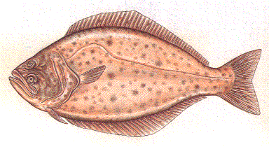
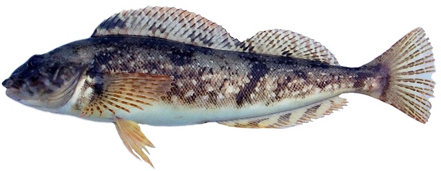
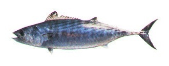
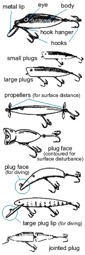
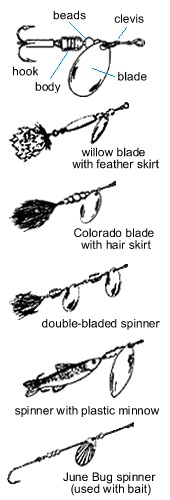
After the spawn, usually in early summer, the fish will move "off the beds," leaving the shallows and moving into areas where there is good underwater structure, usually 8 to 15 feet deep. By this time, the water temperature is usually 68'F to 74'F. The post-spawn period extends from early summer through fall.

    This is where knowing a lake pays off. You can spend a lot of time looking for the fish and not finding them if you don't know where to find traditional structures that will hold the bass during the summer. Shade becomes very important. Cast right along boat docks, because the fish will often hang under the dock to catch some shade.

    In addition to docks, other excellent places for bass during the post-spawn period are submerged trees (stickups) and bushes, areas around old dock pilings, deep coves where shoreline vegetation provides shade, large rock piles, and edges of tale berms.

    Although some surface action occurs at dawn and dusk, the best results come when fishing deeper. And while some hard baits can attract bass (Shad Rap and Rattletrap are good examples), the best results are on plastic or plastic worms and grubs.

    The best are the Senko, Brush Hog, Zoom Fluke, lizard, frog, rat, and plastic worms, such as Weenie, especially the small one with the red head. The best colors are motor oil, purple, and black, or the salt-and-pepper flecked grubs.


    Bass Ponds

    farmer's pond

    One of the best ways to introduce newcomers to bass fishing is to take them to a small lake or farm pond in the spring, when the first warm weather of the year gets the bass hungry, active, and inspired to move into the shallows and carve out spawning territory. From bank or boat, you cast out small lures along the shore, and there are times when the bass seem to smack the lure almost as soon as it hits the water.

    Every spring from March through May, I take my two boys, Jeremy and Kris, on a trip to farm ponds, and we fish out of our little rafts. We paddle around, then cast along the shoreline, using either spinning gear or fly tackle. Floating or shallow diving lures (such as the one-inch Rapala) or small poppers can attract large numbers of surface strikes. We've had many days when we've caught 50 to 100 fish, although only rarely will one be larger than 14 or 15 inches.

    As summer arrives, using plastics such as the Green Weenie will inspire bite after bite, while the bass will snub hard baits.


    Plastics and Hard Baits

    I lie reward of using lures rather than bait is higher catch rates, with catches of 15 to 20 bass during good bites on warm spring days. Alas, you often have to wade through many dinks to hook a few in the 14- or 15-inch class or even bigger.

    So bass anglers who use only lures get more action, try more strategies, and cover a lot more writer than anglers who use bait. The trade-off, however, is a trend toward smaller fish. But it's .III attractive deal, because instead of waiting for the fish, you are pursuing them. Doing it, though, requires the approach of a detective.

    You have to take several factors into consideration: water temperature, water clarity, weather depth of fish, and whether they are in pre-spawn, spawn, or post-spawn periods. Any of these III have a tremendous influence on your approach at any lake or reservoir. Then there is the Like itself, and you must have the ability to find habitat that will hold bass.

    One of the first orders of business is to determine how deep the bass are and what seasonal I influences are affecting them. The year is divided into periods: pre-spawn, spawn, post-spawn, and winter. You recognize these periods by coordinating time of year with water temperature and recent weather trends.


    Summer Worming plastic worms

    Worming takes a lot of skill to do right. Most people cast the worm out and reel it back in way too fast. Consider how it looks to the bass. It needs to appear as natural as possible, and that means working it very slowly. The favored technique with a worm is walking it down shoreline ledges into structure. This simply means retrieving it slowly enough along the lake bottom so it Others right into the intended destination, where a bass is hanging out for the day.

    As the summer progresses and the water temperature continues to climb, the bass become more and more difficult to catch. This difficulty is compounded at reservoirs with dropping water levels that force the bass to move to different areas. The combination is rough on anglers, who must now approach a familiar lake that has had a dropping water level as if it were a completely new water. Add intense waterskiing pressure (where the wake from speeding boats slaps against the shoreline and makes the bass especially jittery), and you face a very challenging scenario. Challenging? By August you might think you'll need the Jaws of Life to get the fish to open their mouths.


    Winter Jigging

    In winter the cold weather finally returns, the metabolism of the bass slows down, and they head to find the warmest water in the lake. Few anglers try for bass during this period because I conventional methods rarely work. It can seem as if there isn't a single bass in the entire lake. What to do? The answer is to drift your boat over an underwater ledge, drop-off, or hole that is 15 to 50 feet deep, then simply jig straight up and down. This technique also can take fish during the pre-spawn period, when a cold-weather snap returns the fish to winter tendencies.

    Using live bait, such as the jumbo minnow, also can take very large fish during this period.


    Downshotting Palomar loop knot

    You practically need the Jaws of Life to get a bass to open its mouth once the rain and cold temperatures arrive in California, right? Well, anglers have found their Jaws of Life with a technique brought in from Japan that solves the annual winter-fishing slow-up. It is called "downshotting" or "dropshotting." This is how the setup is rigged: Tie a 3/16- to 1/4-ounce bell-shaped sinker to your line. From 12 inches to six feet up from that weight, tie a No. 2 hook with a Palomar loop knot (to act as a dropper). Then hook a three-inch Keeper leech worm (best color is oxblood) right through the nose (as if minnow fishing).

    It works during the cold winter months because the bass are deep, often right on the bottom. The secret is to cast out, let the plastic worm sink to the bottom, then let the boat drift so the worm is trailed slowly, just above the bottom. When you get a pickup, do not set the hook, which will pull the worm away from the bass, but reel down to the fish.

    One trick with this system is to use a sinker made out of tungsten, which is harder than lead and can make a tapping sound on rocky bottoms, attracting the bass. Another trick is to use 8-or 10-pound line on your reel, tie on a small barrel swivel, and from there drop down to a 6-pound leader.


    Live Bait

    For bait, use crawdads, jumbo minnows, or shiners. For crawdads, keep them on a cardboard flat. Wave your hands over the top of the crawdads as if you are a sorcerer applying a magic spell ~ first one that moves gets elected for the job of bait.

    Hold the winner on its side with a thumb and forefinger, positioned so the little bugger can't nail you with a pincher, then hook it right between the eyes with the No. 8 hook tied to your fishing line.

    Use no sinker, no leader. Just a small hook. That way the crawdad will swim around most naturally. When a big bass starts to chase it, the crawdad will swim off trying to escape. Nothing gets a big bass more excited than what appears to be a good meal about to escape.

    Toss the bait out toward the buoy, then let the crawdad swim to the bottom. Wait and watch, staring at where your line enters the lake.

    When your line twitches a bit, get ready. Stand with your rod, befit careful not to pull or twitch (if you move the bait, it will spook the bass), and point the rod at the water. Often nothing happens. Five seconds, ten seconds. It will drive you crazy. But think of the logic: You know a big bass is down there (you marked it), you know your crawdad is down there, and you know that something made it move.

    When the slack line begins to draw tight, it means the big bass is picking it up. Get in the set position, and when the line tightens a lot, set the hook hard.

    Note that big bass never jump but instead bulldog in short thrusts of power near the lake bottom.

    Never think that all you have to do is show up, use electronics to find a big bass, and then loss your bait out to catch it. It sure doesn't work that way most of the time. Electronics provide an edge, not a guarantee.


    Insider's Note

    A high-quality electronic fish finder is a must. It shows bottom contour, depth, and water temperature, and it marks fish. But for those who are very serious about bass fishing, you are better off with the paper graphs. Even though they are more expensive because you have to keep buying paper scrolls for them, they are more detailed, even showing the size of individual fish; and because the information is all recorded on paper, you can take it home, lay it out on a table, and study the lake bottom. After doing this for a while, you can get to know the bottom of a lake as well as the layout of your own home.


    Record Bass

    One magic spring day at Otay Lake, Jack Neu caught five largemouth bass that weighed a total of 53 pounds, 12 ounces, probably the largest five-fish bass limit ever caught on planet Earth. I was with Jack on that special day, and as it evolved, it was as if everyone at Otay had been launched into a different orbit from the rest of the world. In a two-hour span at the dock scale, 30 bass weighing eight pounds or more were checked in. Out on the water, though, Jack and I were still at it. He'd caught four that weighed a total of 45 pounds, topped by a 16-pounder. One more and he'd earn a place in history. He got it: It weighed an even eight pounds.

    The secret to catching giant bass, I learned from Jack, is to search for giant bass, then mark, anchor, and fish for that single bass. Start by motoring your boat around a cove or off a point at the pace of a slow walk, and while doing so, study the marks on your fish finder or graph. When you see a big bass, you can feel like a safecracker who had just heard the right click on the dial. At that point, toss out a small buoy to mark the spot. Then motor the boat off to the side, throw out an anchor, and turn off the engine.


    Bass Tackle

    Many anglers will keep several rods ready rigged with spinner baits, plastic worms, rip baits, and one for flipping, so they can be switched at a moment's notice. Many matched combination rod and-reel setups are available.

    Rods: Spinner bait rod (conventional): 6 1/2-foot Loomis MBR783C or 6 1/2-foot Shimano (Jimmy Houston) JHC66MH; plastic worm rod (spinning): 6 1/2-foot Loomis SJR782 or 6 1/2-foot Shimano (Jimmy Houston) JHS66M; flippin' stick (conventional): 7 1/2-foot Loomis FR904X or 7-foot, 10-inch St. Croix Avid AC710HS; downshotting (spinning): 7-foot Loomis SJR841.

    Reels: Conventional: Shimano CU200B or Daiwa ProCaster X 103HA; spinning: Shimano Sahara 2000F or Daiwa TDS2500; flippin': Castaic CA200 (use 15- to 30-pound test line); downshotting: Shimano Stradic ST 2000 FIG (use 6- to 10-pound test line).

    Line: In most cases, 10-pound test is ideal for most applications. Some anglers who use spinning tackle drop down to 8-pound test, and when catching bass in the foot-long class or in crowded lake conditions, they drop down to 6-pound test. Some people using conventional gear and casting large spinner baits, Castaic Trout, or heavy jigs will use as high as 20-pound test.


    Top ten places to fish ...

    Trout:

    1. Sacramento River,
      Redding to Anderson
    2. Lake Davis
    3. John Muir Wilderness
    4. Convict Lake
    5. San Pablo Reservoir
    6. Blue Lake, Alpine County
    7. Big Bear Lake
    8. Frenchman Lake
    9. Del Valle Reservoir
    10. Lake Amador

    Fly-Fishing Trout:

    1. Sacramento River,
      Redding to Anderson (by boat)
    2. East Walker River
    3. Middle Fork Feather River (hike-in)
    4. Fall River
    5. Kirman Lake
    6. Owens River,
      Big Springs to Crowley
    7. Pit River
    8. Crowley Lake
    9. Matterhorn Canyon,
      Yosemite Wilderness
    10. Lake Davis

    Big Trout:

    1. Lower Twin Lake
    2. Bridgeport Reservoir
    3. Independence Lake
    4. Eagle Lake
    5. Kirman Lake
    6. Crowley Lake
    7. Collins Lake
    8. San Pablo Reservoir
    9. East Walker River
    10. Shasta Lake

    Time and Place

    Any time there is a dramatic change in habitat, you will find fish aloft the edge of that border. Long, straight, bare stretches of shoreline do not hold fish. On the other hand, jagged points, coves, rock piles, drop-offs, submerged boulders, and trees do. Look for the change. It might be where a tiny feeder stream is trickling into the lake or where the late-afternoon shade line crosses the water. You must locate and fish these areas. In many rivers, trout will point themselves upstream and sit motionlessly in pocket water waiting for insects to float by. They move just a few inches from side to side when they pick off the insects.

    In many lakes-particularly those with little underwater structure, reefs, or drop-offs-a lot of people think the central purpose of electronic fishfinders lies in finding the little blips that indicate fish. Actually they are best used to examine the bottom contours of the lake. Remember: 10 percent of the water will hold 90 percent of the trout. This is true not only horizontally (at key habitat areas), but vertically as well. You must troll at the precise depth, especially if you want to catch big trout. The rule is that 10 percent of the water will hold 90 percent of the trout.

    In spring, trout are often near the surface, roaming around in the top 10 to 15 feet of water, picking off the first insect hatches of the year and snaring misled minnows. As summer arrives, the warm water on top drives the trout deeper to a layer known as the thermocline. The thermocline is cool and rich in oxygen and food. In the summer the trout will always be in the thermocline. In the fall, usually around the third week of October, lakes will "turn over," as the Stratified temperature zones do a flip-flop, bringing the trout again to the surface for several weeks. When winter sets in, the trout go deep, this time seeking warmer water.

    So right off, the spring and fall are the best times to troll for trout, because the fish are near the surface and no specialized deep-water techniques are required. In the summer, when most people fish, the trout are buried in the thermocline, except for brief periods at dawn and dusk, when they come up to the surface for the evening rise. By that time, however, many people have left without getting a bite. The problem is that summer anglers troll too shallow, right over the top of the trout.


    Fishing Wilderness Lakes and Streams

    Whether fishing at a lake or a stream in the wilderness, identify the promising spots, make five casts then move on to the next spot. Stick and move and keep on. That's the key in the wilder-I l' you ever take a look at the underwater world, you see that after five or six casts, the fish ,tart to get used to your lure. The lesson? If you haven't caught one by then, you are not to time to move on.

    Keep your tackle simple. To keep our backpacks as light as possible, we often keep a half lures in a 35-mm film canister ~ that's it.

    The lure that works best is the gold Met-L Fly. Other lures that work well are the Panther Martin spinner (black body and yellow spots, gold blade), Z-Ray (black with red spots, or gold with red spots), yellow Roostertail (with yellow/black body, yellow backtail, gold blade), or Kastmaster (in gold, rainbow trout, or blue/silver).

    We have another one we call "The Mr. Dunckel Special," after the man who invented it. It is a 1/16-ounce Dardevle spoon that is painted flat black and dabbed with five tiny spots of red paint. It works well in clear-water conditions, when many lures frighten the fish instead of attracting them. The fly-and-bubble combination can work great in high mountain lakes, especially in the southern Sierra.

    To fish the wilderness, you must be willing to hike, and hike a lot. You have to hike into remote areas, then hike some more up and down the stream or around the lake, then hike back to camp. The best I've ever seen at this is my older brother, Bob Stienstra, Jr., the best wilderness trout fisherman around ~ so good that we call him Rambo. When stalking the evening rise, he's a mix of Davy Crockett and a Miwok chief. He wears moccasins and walks softly but doesn't carry a big stick ~ it's more like a magic wand.

    In the wilderness he does not wait around for the fish to bite. Instead he chases them down like a river hunter who would fit right into a Louis L'Amour western.

    He sneaks up along the stream, walking softly and low, keeping his shadow off the water, then zips short casts into the headwaters of pools, the edges of riffles, tail-outs, and the pockets along boulders.

    Rambo doesn't wait long for an answer. He either gets his bite or moves on, making only a few casts at each hole, and therein lies his secret. He covers a tremendous amount of water in a short time.

    Rambo has the stamina to carry out this strategy. He covers about a mile of river per hour, walking almost as much as fishing, but in the process he gets a fresh look at a new hole every few minutes. Wearing those trademark moccasins, he moves quickly and silently, stopping at the good-looking spots to make short but precise casts, then moving on to the next. I've never seen him so happy as when he's in his moccasins in the wilderness, then comes around a bend and spots a deep river hole, the kind where the water flows through a chute at the head of it like a miniature waterfall. He knows what's ahead, and the vision is enough to compel him onward.

    It's like you've used a time machine to return to the days of Joe Walker, the greatest trailblazer of them all, and Liver-Eatin' Johnson, the legendary woodsman who inspired the movie Jeremiah Johnson.


    Fishing a Lake from Shore

    When fishing a lake from the shore, use very light spinning gear: an ultralight graphite rod with a micro spinning reel and light line. Never use anything heavier than 4-pound test.

    The most simple is a single-hook rig. You start by slipping a small barrel sinker (for casting weight) over your line, then tying a snap swivel to the line. Add 14 inches of leader and a No. 8 hook. A key with this setup is making sure your bait floats up off the bottom a few inches. That can be done by using Power Bait, Zeke's Floating Cheese, or a marshmallow. If you use a night crawler for bait, you can use a worm inflater to pump it up like a little balloon to make it float. A worm inflater is actually just a small empty plastic bottle with a hollow needle. You jab the needle into the night crawler, give the bottle a squeeze, and the little guy looks like a tiny brown balloon.

    A more advanced two-hook rig is very popular. Take your fishing line in hand and slip on a clear red bead, then tie on a snap swivel. Tie on a Lyons Leader (developed by Dave Lyons), which consists of a loop (which is attached to the snap swivel), with 18 inches of leader to a No. bait hook on one side, then eight inches of leader to a No. 8 egg hook on the other side.

    To bait up, place half a night crawler on the bait hook, using a worm threader (see Lures) so it will lie straight. Then place a salmon egg on the other hook, working it up to the eye of the hook, and then mold a small piece of Power Bait (chartreuse or rainbow sparkle) over the shank and hook.

    With a careful flip, toss it out 35 or 40 feet. What happens is that the night crawler will sink the bottom, but the Power Bait and egg float up a bit, just above any weeds down there, right here the trout are swimming.

    The trick is to put your rod down, leaving the bail of the spinning reel open, then take the I mc from the reel and place it under the light plastic lid of a worm tub. There's virtually no reliance, so when a fish picks up the bait, he doesn't get spooked. But when the line gets pulled out from under that lid, you know darn well there's something going on down there. Heh, heh. When your line moves a bit in the water, then tightens, flip the bail over on your reel and set the hook.


    Fly-Fishing River Trout

    The #1 advantage of fly-fishing is that you have the opportunity to fish more, not less, than other methods. The fact that fly-fishing qualifies as an art form for many is a bonus.

    Remember that 90 percent of trout feeding is subsurface. That is why nymphing - short lining weighted nymphs in pocket water - is an outstanding way to catch trout in freestone streams. A stream is one that flows over rocks and boulders.

    The following fly patterns will make a good fly box for most any stream: Pheasant Tail, Prince nymph, Hare's Ear, Z-Wing caddis, Elk Hair caddis, Adams, Light Cahill, Yellow Humpy, Royal Wulff, woolly bugger, and Zonker.

    With chest waders and a wading staff, wade near the center of a fair-running stream. Next, zip short casts to the little spots that hold trout. The fly should land just upstream of the spot and be allowed to drift past the spot. Then, pick the fly up, backcast once to dry it off, and zip the cast to the next spot on the river. With a spinning rod you have to retrieve the lure all the way back through unproductive water. That is why you spend much more time actually fishing promising spots by wading and fly-fishing than by using a spinning rod.

    After delivering your fly, "mend" the line (flipping it to the outside), so that the fly will drift straight with the current as if no line were attached. If the fly skids instead of drifts, not only will no trout hit it, but you may even spook the hole.

    Follow the fly with your fly rod; that is, keep your rod pointed in the direction of the fly, and then watch your line carefully on the drift. Often the trout are just sitting in the pockets, moving just an inch or two either way to pick off insects as they float past. Remember, you don't need much line out. If you are fishing a nymph (wet), all you will see when a trout grabs it is the downstream flow of your line stopping. You have to strike right now. You'll never feel a thing. It's all in the watching.

    If you have difficulty mastering this, a great trick when fishing wet flies or nymphs is to use a strike indicator, which is attached just above where the leader and fly line are connected. A strike indicator floats, providing an exciting visual tip-off to every strike. Shops sell Styrofoam, strike indicators in different colors. Another trick is to use the sleeve of a colored floating line and thread it on the head of your leader. When fishing deep water, use a Corky, held in place with a small piece of toothpick. I've used this trick to catch 10-pound rainbow trout on a fly rod.

    In fishing cold, freestone streams, Ted Fay designed a system using two flies simultaneously, usually both weighted nymphs, a Stonefly and a Bomber, and fishing pocket water with short casts. It was a fantastic display one early summer day when he caught 10 trout on his first five casts and. then just grinned at me as if he did it all the time.

    Remember that 90 percent of the time, trout will be feeding subsurface. That is why nymphing is a very effective way to catch trout in California.

    The other 10 percent of the time is when there is a surface hatch of insects, which in turn inspires a surface feed. This usually occurs at dawn and dusk in summer for 30 minutes to two hours. In the fall it can occur for hours during a good caddis hatch. It is exciting fishing because it is so visual to see the hatches, cast to rising fish, see the strike, and see the set. This is when long casts, accuracy, and soft deliveries can make all the difference. If you slap the line on the water in your delivery, you will spook the fish off the bite. That is why you should start with short casts at each spot, mastering the soft presentation, and then extend your casts out to work the entire spot.

    Fly-fishing is not only productive, it teaches you tremendous lessons about insects, water temperature, feed patterns, and seasonal cycles. Fly-fishing is a fun, exciting sport that provides the maximum intimacy with your river surroundings. You get more than fishing; you get an experience that touches all of the senses.


    Trolling a Lake

    More people troll for trout than try any other method across California's hundreds of lakes and reservoirs, and the Dunckel method can help any of them catch more and larger fish. The key is getting the depth, trolling speed, and rigging exact.


    Trolling Speed

    The natural way to select trolling speed with lures is to trail the lure alongside the boat and watch to see if the action is exactly right. A tip is to let the lure trail about 10 feet behind the boat, then check it out, because many lures behave differently with more line in the water.

    When using metal lures, you can go a bit faster. When using Rapalas or Rebel-style bass lures for brown trout, it is important to troll slower than when using flashy metal lures for rainbow trout. When you are trolling with flashers and a night crawler, you want the blades to just barely tumble, not spin crazily.

    Most boats troll way too fast. Add a trolling plate to any motor larger than two horsepower in order to be able to slow the boat. A trick I use on my boat is to use a high-thrust transom-mount Minnkota electric trolling motor (to keep it from draining the batteries for my engine, it is wired to two separate batteries). You have to be able to control your trolling speed perfectly. At times, fast can work just fine. At most other times, slow is better.

    If you are renting a boat at a lake, be prepared to get one with a motor that doesn't have a trolling plate by bringing along a five-gallon bucket with a rope. You can tie the bucket to the side or drag it behind to slow the boat.

    Never run your boat straight down a lake. Instead try trolling zigzags and figure eights over a hot spot ~ or stop the boat completely, then give it a surge. Why? Each of these actions makes the lure drop in the water, fluttering as it goes down as if wounded. Then, when the lure gets straightened out by the line, it will swim as if trying to escape. My dad and I discovered this by accident years ago when my engine ran out of gas one day, stopping the boat and causing the lure to drop in the water. When we both started to reel in, big trout immediately hammered both of our lures.

    Another great trick is to take advantage of windy days. A breeze can often help by creating a riffle on the water, which attracts the trout to come up shallower. If the wind blows enough, it can provide the perfect trolling speed. I will turn my engine off and let the late-afternoon breeze push my boat over the best spots while the lures trail behind the boat.


    Trolling Depth

    In summer, trout will be locked in the thermocline as if they are locked in jail. This depth can vary a great deal from lake to lake, but without a way to troll deep and test different depths, you will likely be fishing right over the top of all the trout.

    Many methods are available to help you troll deeper, including using downriggers, plastic planers, or leadcore line, or just by adding weight. With downriggers, no heavy weight is required on your line, so using very light tackle is possible even when fishing deep. With leadcore in small lakes, a trick is to tie on 30 feet of leader and then troll a Triple Teaser. I have always used Scotty downriggers. My personal choice is the Scotty Depthpower, two of which are mounted on my boat. Whatever you choose, just make sure you do it.

    Always test different depths starting deep and ending shallow until you find the fish. Down-riggers and leadcore trolling line are excellent for testing, because downriggers provide exact readouts of how deep the line is, while leadcore line is color coded. Therefore when you find the fish, you can return to the same depth at every drop. Trout will stay in an ideal temperature zone as if in lockdown.

    The exceptions are short periods at dawn and dusk, when the trout often feed on the surface. In spring and fall, when the water is cool, the trout are often in the top 10 feet of water as well.


    Drift Jigging

    This is a wild-card option that can produce large fish at lakes. Instead of trolling, you turn the engine off and let the boat drift slowly over prime areas that have been identified as holding trout. You let a lure descend straight down from the boat; when satisfied with the depth (often best right off the bottom), you simply jerk the rod up, then let the lure settle back down. You repeat this over and over. Crazy? Give it a try, especially in late winter. Many huge trout can be caught with this method when nothing else will work. The best lures for drift-jigging for trout are a white crappie jig, Gitzit, and Krocadile spoon.


    Trout Lures

    Here's what you might look for: Humdinger (purple, blue/purple, or gold with red stripe), Cripplure (gold or gold with red stripe), Rainbow Runner (purple or red), Needlefish (rainbow or gold with flecked dots), Triple Teaser (white with red head), Z-Ray (gold or white with red dots), Roostertail (black/yellow with silver spinner), Kastmaster (gold or rainbow trout), Mepps Lightning, Little Cleo (gold), Bingo Bug, Speedy Shiner (gold), Rapala (fire tiger), Rebel Froggy, F7 Flatfish (frog), Wee Wart, Koke-A-Nut, and Super Duper (gold/red).

    A good trick is to troll a black or dark-green woolly worm fly behind Cousin Carl's Half-Fast flashers. Another excellent trick is to use a small dodger, such as a Sling Blade, and then add 18 inches of leader to your lure.

    When using lures, always test them with and without snap swivels. The lures must look perfect as they are trolled. In addition, when selecting a lure for size, be sure to add the length of the snap swivel as if it were part of the lure. For instance, a one-inch lure with a 1/4-inch-long snap swivel would be seen by the fish as a 1 1/4-inch minnow. This is important when matching the size lure to the size forage in a lake.

    Flashers and night crawlers: Use Cousin Carl's Half-Fast flashers with the two half-brass and half-silver blades in the flat (not dimpled) finish. I also like the Sep's Mini Flashers because of their minimal drag. Many other types can work, and the most famous are the Luhr Jensen Ford Fenders. In any case, be sure you follow the directions on the back of the container and have the exact amount of leader that the manufacturer recommends. You just plain have to get it right.

    Use half a night crawler and work it onto the hook so it lies perfectly straight in the water, with a small piece running free behind the hook. This can be done quickly with a worm threader. You skewer the night crawler with the threader, a small-diameter piece of metal tubing, and place your hook on one end of the tubing. Then work the night crawler from the tubing to your hook and line. Thus the worm lies perfectly flat in the water.

    If you keep getting short strikes, with the trout consistently biting off the ends of your night crawlers, resist the urge to shorten the night crawler, as this will reduce its action in the water. Instead add a stinger hook. To accomplish this, when you tie on a hook, do not trim off the excess line. Tie on an additional hook to the line, then hook the end of the night crawler with it as a trailer or stinger.


    Color Under Water

    As sunlight penetration in the water diminishes, so does the vividness of colors. In fact, as you go deeper, all colors eventually turn black, but at incredibly different rates.

    In the middle of the color spectrum is lime green or chartreuse, which shows up very well between 25 and 45 feet deep ~ exactly where most salmon are during the summer months, when the plankton is thick and salmon are corralling schools of anchovies. When in doubt, go with chartreuse.

    Bright red turns black underwater faster than any other color. That makes it effective only in shallow water, where light penetration is highest. If you fish deeper than 40 feet during typical ocean-water clarity, red can lose its powers as an attractant. To the fish, it will actually appear black. The best time to use red for salmon is during the fall, when the salmon's spawning mode kicks into overdrive and when the fish school outside the entrances to major rivers just 25 to 35 feet deep.

    On the opposite end of the spectrum, blue is capable of reflecting the smallest glimmers of light. That is why blue is the most effective color when fishing deep or in ocean water that is thick with plankton or otherwise has low water clarity. Some anglers have told me that blue should never be used, since it is disguised by the water and fish can't see it. According to a series of tests, the opposite is true. Blue shows up in deep water better than any other color.


    Insider's Notes
    • If you are not catching fish, drop to a lighter line size. In tests I've done, 4-pound line can outcatch 6-pound line 10 to 1 in areas with high water clarity.
    • If you get a strike yet no hookup, immediately let out 15 feet of line, then let it tighten. This is a great trick. The fish will believe it has struck and wounded the bait, and will then come back to eat it.
    • During periods of water drawdowns at reservoirs, take a hard look at the dry lakebed and memorize the areas that will attract trout during high water. At the end of summer, if you beach your boat and hunt the obvious snags, you can find dozens of lures and flashers.


    Tackle and Rigging

    Spinning: Try a 6 1/2-foot Loomis SR781 rod matched with a Shimano Stradic ST2000FG reel. Many excellent factory-ready combo rigs are available from every major manufacturer, including Shakespeare, Pflueger, Abu, Daiwa, and others.

    Trolling: A 7-foot Loomis PR8400C (rated for 6- to 12-pound line) matched with a Shimano Calcutta CT50 is a stellar setup. For deep-water trolling with a downrigger or using leadcore line, switch to a larger capacity reel, such as the Abu Garcia Royal Extreme RXT 6600C reel; this works a lot better than spinning rod and reel setups-you don't get the line twist you sometimes get with spinning reels, and with a 7-foot rod (instead of a standard 6 1/2-foot spinning rod), it is a lot easier to set the hook quickly.

    Fly rod: My personal favorites: Sage 5-weight, 9-foot XP 590-4, with a Galvan reel and Simms waders. Fenwick also makes an outstanding introductory package based on its 8 1/2-foot 6-weight. Use either 3X or 4X leaders, 7 1/2 feet long for newcomers to the sport, 9 feet long for most conditions, or 12 feet long for still, clear water. The more advanced fly fisher can try the 8 1/2- or 9-foot Loomis 6-weight or the Sage 6-weight, matched with an Abel, Galvan, or Loomis Adventurer reel.

    Line: The standard line for trout is 6-pound test. In lakes with high water clarity use 4-pound test or no higher than 6-pound test. In lakes with low water clarity you can get away with 8-pound test. A solution to the problem of line-shy big fish has been solved with the introduction of fluorocarbon leader material. Fluorocarbon line is very strong yet virtually invisible. It allows anglers to use strong line in all applications for line-shy big fish, from saltwater fly-fishing for bonefish to trolling for trout in crystal-clear lakes. When reeling the backing on, be sure to leave enough room for your fly line.

    Backpacking: Take a four-piece Daiwa HL-604 ULSS rod matched with a Daiwa Spinmatic 50OZ reel or a six-piece Daiwa Apollo AG666BP rod (at times difficult to locate) matched with a Fin-Nor MegaLite ML-1000 spinning reel. Both rods come with hard plastic tubes that will fit in a backpack.


    Top ten places to fish ...

    Mackinaw Trout

    Mackinaw Trout
    1. Lake Tahoe
    2. Donner Lake
    3. Bucks Lake
    4. Hell Hole Reservoir
    5. Bear River Reservoir
    6. Gold Lake
    7. Stampede Reservoir
    8. Gilmore Lake
    9. Fallen Leaf Lake
    10. Caples Lake


    Time and Place

    Mackinaw trout inhabit only cold water, preferring temperatures no warmer than 50'F. They often roam hundreds of feet deep during the summer months but emerge in shallower areas during the coldest days of the year in late winter. They are also especially light sensitive and can be driven to darker and deeper depths during days with flat water and bright sun and during nights with a bright moon. So your best bet is to fish during a new moon, overcast weather, or right at dawn. There is often a bite from dawn to 7:30 A.M.; then it gets spotty until about 9 A.M. After that, on blue-sky days you might as well quit.


    Tricks

    A real key to landing Mackinaw is "learning the lake." Every lake has habitat that will hold fish. With Mackinaw, 90 percent will be in about 10 percent of the water. So with a depthfinder, learn these spots and fish them exclusively.

    Often the best fishing is in cold, overcast weather with a wind chop on the water. The reason these conditions are good for catching big Mackinaw trout is that the fish are less likely to get spooked off the bite, which is common during clear, calm, warm days, especially following full moons.

    Some people swear by vertical jigging, but your arm can wear out far before a Mackinaw decides to bite.


    Rigging

    The most productive setup is a dodger-and-minnow combination. For bait, use a large minnow (at Tahoe, use a Tahoe redside minnow, the only legal minnow there). Thread a treble hook through the minnow. To do that, take a six-inch taxidermy needle and your line and start it through the anal opening. Pass the needle through the minnow's mouth, then tie the treble hook to the line so that the shaft of the hook is entering the fish. It looks just like a lure but is better because when the big Mackinaws come up to nibble, they taste fish, not plastic.

    To make it even better, the minnow is best trolled 18 inches behind a No. 00 solid chrome dodger made by Luhr Jensen. The dodger-and-minnow combo provides perfect action, attraction, and smell, especially during the summer months, when the Mackinaws sometimes have to be teased into striking. When the bite is tougher, a shorter leader (12 to 14 inches), which can provide more back-and-forth action, is a good insurance policy.

    In the cold months from November through May, you can get a hookup by trolling an ivory-colored M-2 Flatfish lure ~ your line clipped to the downrigger line to reach the proper depth, of course. J Plugs also can work very well. I have also used giant spoons, such as the six-inch Five of Diamonds and Dardevles, in red and white or chartreuse with red spots. Some people will hover over a spot and jig straight up and down with Krocadiles or Gitzits. This is called vertical jigging.

    If you are fishing a lake the first time for Mackinaws, you need a good depthfinder to locate the deep bottom ledges. The fish are often suspended just off the deep underwater ledges. With it depthfinder, search for sudden drop-offs, then troll just off them. The converse is also true: Long, sloping bottoms will not hold Mackinaw trout.

    By using Scotty electric downriggers that provide precise depth, we are able to troll precise depths. A downrigger is a separate reel of wire line that, s heavily weighted ~ your fishing line is attached to the wire line by a clip. When a fish strikes, your fishing line pops free and you fight only the fish, not any weight. That is why downriggers are so perfect for trolling deep.

    Even though the fish come big and often go deep, you don't need particularly heavy tackle when using downriggers. Most of the prime Mackinaw water is not loaded with bottom structure, so you usually don't have to fear the fish will wind the line around a submerged tree stump or other snag, breaking it. In addition, it is the downrigger that takes the strain of the lead needed to get deep, not the rod.


    Tackle

    Use a 6.5- to 8-foot graphite composite rod rated for 15-pound line and a level-wind reel that will hold at least 250 yards of line, filled with fresh 10- to 15-pound line. Some commercial charter boats use wire line and heavy rods, then try to rack up large scores of small fish that hardly fight at all. For the most fun, resist using heavy tackle and instead use downriggers for trolling, which allows the use of lighter tackle.

    Rod: 8-foot Shimano TDR1802.

    Reel: Shimano Triton TRN200.

    Line: 12-pound test green DuPont Magna-Thin or Maxima Ultra-Green. Note that line can be critical for Mackinaw trout, since they usually live in deep, very clear waters. That is why you must use a line that is nearly invisible and very small in diameter, so that it cuts through the water instead of creating a large bow.


    Top ten places to fish ...

    Steelhead

    1. Smith River, Main Stem,
      forks to U.S. 101 Bridge (by boat)
    2. Smith River, Middle Fork
      along Highway 199 (by shore)
    3. Klamath River
    4. South Fork Eel River
    5. Feather River
    6. Mad River
    7. Mattole River
    8. American River
    9. Trinity River
    10. Redwood Creek


    Time and Place

    Early in the winter, when the seasonal rains are just starting and river levels are beginning to come up, steelhead will often wait for a storm (and higher stream levels) or higher tides before leaving the ocean. In small coastal streams, the steelhead will shoot through the mouth of the river during a high tide, then hole up in the lower river lagoon until stream flows are high enough upstream for them to venture onward. The recipe for steelhead is simple: Just add water. The ideal situation is enough rain to freshen up the river and attract the steelhead upstream, but not so much rain that the river is muddied up or the stream is flowing too high and fast to fish.

    If the stream is "greened up, freshened up," then you are in business. Steelhead will enter the river system and head upstream, stopping in the slicks just upstream of white water, in the holes just downstream of white water, occasionally along the edges of riffles, in holes on sharp bends in the river, aside large boulders, and in tail-outs (especially on major rivers early in the season).

    The type of water that holds steelhead in a river is similar to that which holds trout in a mountain stream, projected on a larger scale, of course. Steelhead use the river as a highway, then spawn in the tributaries. They don't like to stop moving, but they will at certain areas in order to rest a bit, especially after swimming through some rough water. This is when you get your chance. I like to fish the holes, especially above white water. After a steelhead charges through that white water, it is bound to hole up for a while to rest before heading on upstream.


    Tricks

    You simply cannot saunter up to the riverbank and start casting. That is like throwing bricks in the river and expecting the fish to bite. If the river is clear, particularly in canyons, stop 15 to 20 feet short of the shoreline and make your initial casts from there. When the water is clear, any sight of casting motion, even the shadow of the rod on the water, can spook the fish.

    Get up early and be on the water before first light. Never spend much more than 20 or 30 minutes at a spot. Then, when you're on a spot, fish the entire hole: the head, the middle, and the tail. Always keep moving. Most steelhead streams in California are bordered by two-lane highways with dirt pullouts alongside many of the best spots, which allow anglers to park and then hike down to the river.

    The first few casts should not be long casts across the river. You could scare off the ones closer to the bank by casting right over their heads if you cast long. Instead, the first few casts should be along your side of the shore, then gradually reaching farther out. Work the entire hole, not just the head, tail, or middle, and if you don't catch anything, get the heck out of there and try another spot.

    After the cast, the bait must drift downstream as if no line is attached, as if the drift of the roe is completely natural. The steelhead has to ' think this is for real. I remember that with every single cast. It is absolutely essential to get a good drift.

    A big error many anglers make is "skidding" their bait. This happens when the line is tight and the bait is pulled across the current instead of drifting with it. You'll never get a bite with skidding bait.

    When a steelhead bites, it's an exciting moment, one you'll never forget. Like so many fish that are tremendous fighters, their bite is often quite light. The reason is that the fish are often resting, finning in place, head pointed upstream, when along comes this chunk of roe drifting downstream. Instead of a savage attack, they usually just move over a few feet in the stream to stop the passing bait.

    Another reason for a light bite is that steelhead are often just mouthing the roe, that is, stopping it and then burying it in the gravel river bottom. like salmon, steelhead bury their eggs in river gravel, where they hatch after six weeks.

    It takes time on the water to develop a "touch," to be able to discern the difference between a steelhead stopping the bait and a sinker hitting a rock on the river bottom.

    You must be able to feel your sinker hitting the bottom. After getting the hang of a good drift out of each cast, feeling the sinker drifting down along the river bottom, you suddenly become so tuned in that whenever you feel anything weird, you know it's a fish and not a rock. The bite of a big steelhead usually feels more like a suction than a jolt, and when you're on top of your game, you can tell the difference every time.


    Insider's Notes
    • When big steelhead are first hooked, they make a tremendous run downstream, one of the most exciting moments in all fishing. If they get into white water, it's good-bye. So the challenge is to turn the fish before it "can get downstream on you," as we say. A great trick from shore is to kneel on a rock and point the butt of the fishing rod at the steelhead, in the process putting a huge bend in the rod and tremendous pressure on the fish. We call this "giving them the butt." Often you can remain at a stalemate for many minutes with a big fish in this position, where the fish is unable to head downstream and escape into the rapids, but at the same time is too powerful for you to gain any line. Once a big steelhead starts swimming cross-stream, instead of up and down the stream, you are on your way to landing it.
    • When steelhead are easily spooked, such as in clear, slow-moving water, sometimes the bites are so light you will feel nothing at all. If you wait for a big yank, you might as well hire yourself out as a statue. Instead, watch the fishing line as it trails out across the river during these periods. When the bow in it tightens a bit ~ bang! ~ set the hook, because that is often the only discernible sign that a steelhead has stopped the downstream flow of the bait.
    • When you get a hookup while fishing from a boat, always anchor the boat in an eddy to fight the fish, or jump out (with hip waders) and fight the fish from shore. If you stay in a boat during the fight, when the fish makes its power runs downstream, all the boatman has to do is let the boat drift down the river with the fish, and much of the excitement of the run is lost.
    • A big steelhead is the fastest freshwater fish in California, capable of covering 27 feet per second.
    • The steelhead is special because it is spawned in a coastal freshwater stream and then swims out to sea, where it spends much of its life. The steelhead, unlike salmon, does not die after spawning. In shorter streams where the swim is not long or hazardous, many return to spawn for a second or third time. Steelhead that have been in freshwater for a time develop a broad red stripe on their sides and look like a large stream rainbow; this is most common on the Klamath River. In the ocean, both salmon and steelhead are steel blue on the back and silvery on the sides.
    The 1 Percent Club

    If you catch a 15-pound steelhead, you have joined California's 1 Percent Club. That is because 97 percent of California's anglers have never caught a steel-head, according to a survey conducted by Fish and Game. Out of the 3 percent who have, just one-third have caught a 15-pounder. If you are an honorary member of the 1 Percent Club, you are probably both lucky and good.


    Rigging

    Wear a fishing vest or jacket that is set up in advance with key tackle elements in separate pockets. Readily accessible should be a small spool of leader material (usually 8-pound Maxima), pencil lead, hooks, and a pair of clippers and pliers hanging from plastic ties. A covered tub of roe for bait should be ready in another pocket. It is advisable to have pre-tied leaders readily accessible so you can spend your time fishing, not tying rigs after snags and break-offs. A large net is required to land steelhead, even from shore, usually with an opening about three feet across; small trout nets will not work, especially if you try to land California's first 30-pound steelhead.

    Use the three-way swivel concept. You tie on three feet of leader and your steelhead hook to one swivel (available pre-tied at tackle shops) and four or five inches of leader with a dropper loop to another swivel. From the dropper loop, clamp on a pencil sinker. Use roe for bait.

    Another option for weight is to use a Slinky, which is a special sinker less apt to get snagged in shallow, rocky areas. Attach the Slinky on a snap swivel, then slip your line through the eye of the snap swivel. From the end of your line, tie on a barrel sinker. From the barrel sinker, add three feet of leader to your steelhead hook.

    Other options include putting a little Styrofoam Glo Ball or plastic Corky on the line at the eye of the hook as an attractor, or using Puff Balls instead of bait.

    Some shoreliners use lures, such as the gold Little Cleo, Kastmaster, or artificial egg clusters, but this can get expensive; snags are quite common because it is absolutely necessary that you drift your offering for steelhead near the stream bottom.

    By boat you can rig the same when using bait. However, another good system is using Hot Shot or Wee Wart plugs. Let them flutter in the current behind the boat while the guide uses the oars to keep the boat almost motionless. Another system is to use a Hot 'N' Tot plug, remove the hook, and add two feet of leader and a hook with a threaded night crawler or a fly for bait.

    Fly fishers have their best success using the Brindle Bug, Silver Hilton, Assassin, or even a dark woolly worm.


    Tackle

    Conventional: 8 1/4-foot Fenwick HMG rod with an Ambassadeur 4500 or 5500 reel, or an 8 1/2-foot Loomis STR1024C rod matched with a Calcutta 250 reel.

    Spinning: 8 1/2-foot Loomis STR1024S rod matched with a Shimano Stradic ST 4000FG reel, or the 7-foot Shakespeare Ugly Stik with a rear-drag spinning reel SPA040R.

    Line: Use 10-pound test if water clarity is fair, 8-pound test if it's clear, and 6-pound test if it's very clear or being used by an extremely skilled angler. On the Smith River in Northern California, virtually everybody uses Maxima Ultra-Green.

    Fly-fishing: 9-foot Sage 8-weight rod, an Abel saltwater fly reel with spools loaded with sink-tip and floating lines, each backed with 300 yards of 30-pound Spectra. I use a 10-foot Sage 8-weight SP 8100-3 with an Abel saltwater fly reel. Use a 10-pound leader and knots with 100 percent strength. For juvenile steelhead, or "half-pounders" as they are called (actually, they can be as long as 15 to 20 inches), a 6- or 6/7-weight rod suited for rainbow trout is acceptable. A good match is an 8 1/2-foot Fenwick 8-weight IronFeather IF 866 with a Pflueger single-action reel.


    Top ten places to fish ...Sturgeon

    Sturgeon

    1. San Pablo Bay, ''Sturgeon Triangle,''
      bordered by China Camp, Buoy 5, and the Pumphouse
    2. Suisun Bay, Mothball Fleet
    3. San Francisco Bay, Richmond Bridge
    4. Lower Delta, Middlegrounds,
      between Roe and Ryer Islands
    5. Sacramento River, southern tip of Decker Island
    6. South San Francisco Bay, Alameda Rock Wall
    7. South San Francisco Bay, Dumbarton Bridge
    8. Cache Slough, Sacramento River Delta
    9. Carquinez Strait, Mare Island Rock Wall
    10. Sacramento River, Knights Landing/Colusa


    Time and Place

    The season, tides, and water flows are critical to sturgeon.

    While sturgeon live much of their lives in the ocean, they will enter estuaries in larger numbers from Thanksgiving through early summer, when there are new opportunities for feeding or a significant push of freshwater through the estuary.

    Fast-moving tides, especially minus low outgoing tides, will kick up feed on the bottom, which can get the sturgeon on the prowl. Slow tides often can mean terrible fishing, especially during periods of little rain and slow water flows.

    A slow tide in the San Francisco Bay Area is when there is little difference between a high tide and the following low tide. For instance, a high tide of 4.1 feet followed by a low tide of 3.6 feet has a differential of only .5 feet of moving water. That is very slow. In comparison, a high tide of 7.8 feet followed by a low tide of -.2 feet has a differential of 8.0 feet of moving water ~ a fast tide.

    During periods of high rainfall, when the push of outgoing freshwater is quite high, tides don't make much difference. But since heavy rain periods occur only rarely, sturgeon anglers must instead attune themselves to how tides affect the fishery.

    The best fishing in the San Francisco Bay system is during outgoing tides just before (very good) and during (good) a cycle of minus low tides. More specifically, the best period is during the latter part of an outgoing tide, such as on a Thursday afternoon just before a weekend of minus low tides. Many sturgeon anglers talk about "big minus tides," but the best fishing is usually just before these big minuses and almost never just after the big minus tides have arrived.

    Since minus tides occur late in the day during winter, the sturgeon fishing is often best in the winter, in the late afternoon. To fine-tune it a step more, the best fishing is often during the two days prior to when the minus low tides begin, from 3:30 to 5:30 P.m. Tide books identify these periods. They phase in and out in two-week cycles throughout the winter and spring.

    You do not need to be a slave to fishing to catch sturgeon ~ that is, staying on the water for many hours in order to hook this fish. Often we fish just two or three hours, and many times we have often just started fishing at 3:30 P.m., right when others are returning home, skunked from slaving away on the water all day, frustrated.


    Tricks

    One key is to use a Sturgeon Board. It not only works as a rod holder when the boat is rocking around (it also can be used from shore or on a pier), but it can raise your rate of successful hook-sets. It was invented by Keith Fraser, the Bay Area's sturgeon wizard.

    The Sturgeon Board measures 58 inches long and 2.5 inches wide. At the top is a .75-inch piece with a slot in the center where the rod is placed. There are also two three-inch-high vertical pieces on each side of the board, located 16 inches from the bottom. Those vertical pieces keep the reel upright, and the pieces at the top of the board with the slot keep the rod in place.

    The board, with the rod sitting in it, is rested at a 45' angle against the boat rail. The rod is 101 untouched until a fish bite is registered.

    Fraser will cast out, reel in the slack, put the rod in place, and stare at the rod tip. His focus is so intense that sometimes he resembles the Sphinx. Should there come a bite, Fraser will carefully lift the butt of the rod, which tips the rod forward, using the slotted piece at the end of the Sturgeon Board as an axis point. If the rod tip is pulled down again ~ and often it can be less than an inch ~ he slams the hook home.

    "Mistakes are easily made," Fraser explained. "The thing to remember is that even though sturgeon are huge, their bite is often very delicate. It is more of a soft pump than anything else. Also, the fish are very sensitive to anything unusual. If they feel any movement or agitation with the bait, it can spook them. If you jiggle the rod at all, they're gone."

    That explains why sturgeon fishing can be so difficult for so many. By moving the rod around, even just a few inches, you can scare off the fish.

    "Whether anglers are holding their rod or not, what usually happens with most guys is that when they get a bite, they immediately pick up the rod or get excited and move it around a bit," Fraser said. "Sometimes they will even stand up, getting ready to set the hook, waiting for another pumper. But sturgeon are so sensitive that just by sensing the moving of the rod like that, the fish get spooked off the bait. The sturgeon never comes back, and the guy doesn't catch anything. It happens over and over."

    A similar system is used by delta guide Barry Canevaro (see the section on striped bass), but instead of a Sturgeon Board, he uses what are called Balance Wedges for each rod. A Balance Wedge is a simple V-cut wedge, in which the rod rests like a balancing teeter-totter. When a fish bites, the rod tips forward. Canevaro then gently picks up the rod, points it toward the sturgeon, and stares hard at where the line enters the water. When the line moves a bit, sometimes just an inch or two as the fish tightens any slack, Canevaro sets the hook. That tightening line indicates that the fish has the bait in its mouth.

    Using the Balance Wedge is also very effective when fishing in deep water channels in the delta or in the San Francisco Bay during times when sturgeon are feeding on the roe of spawning herring. When a herring spawn occurs, you can gather roe from seaweed, pilings, or rocks and use it for bait. The roe is only effective for bait during a herring spawn, however. During non-spawn periods, using whole herring for bait can be more effective.


    Insider's Notes
    • A variety of bait robbers can knock the bait off the hook, particularly when you are using mud shrimp for bait. I wind elastic thread around the mud shrimp a few times to secure it more firmly to the hook.
    • During strong tides, your bait can float up off the bottom, away from where the sturgeon are using their round, vacuum-cleaner mouths to filter feed through the mud. The solution is to place a rubber-core sinker about eight inches up from the bait, which will keep the bait right on the bottom.
    • To get proper hook penetration on the set, tighten the drag 100 percent to ensure there is no line slippage. Once the fish is hooked, immediately back down on the drag for the fight.
    • The white sturgeon is the largest freshwater fish in North America. In the past century, there are records of sturgeon reaching 20 feet and 1,900 pounds. Sturgeon grow slowly and live for many years, some reaching 100 years of age. They do not spawn every year, as do most other fish, but they can spawn once every six or seven years. Because the fish may live at sea for periods of time, even up to eight years in rare cases, the variation in their numbers in bay waters can give the appearance of great population fluctuations.
    • Commercial netting in the Carquinez Strait nearly wiped out the sturgeon. In 1917 a complete closure was put into effect until 1954, when sportfishing for sturgeon again became legal. To protect juvenile sturgeon and large adult spawners, it is illegal to keep sturgeon under 46 inches or over 72 inches. Sport anglers now regard the sturgeon as a world-class fishery, with many encouraging catch-and-release fishing to help ensure future successful spawns, many large fish, and a productive future.


    Tackle and Rigging

    Rods: A great rod is the 7-foot Shakespeare Tiger BWC2201 or the Berkley Power Pole.

    Reels: Try the Shimano TLD Star 20/40S or the Penn 3/0.

    Line: Most anglers use 30-pound line. Some prefer 20-pound line to make casting easier; others Eke to go heavier, to 40- and even 60-pound line, in case they hook one of those elusive 300-pounders. Terminal rigging: Start by placing a slider over your fishing line. A slider is a tube with a snap swivel connected to it, a cheap piece of tackle available at shops near places where sturgeon are caught. With the line going through your slider, tie a strong snap swivel to the end of the fishing line. Clip on a pre-tied sturgeon rig to the snap swivel on your line, and then clip your sinker to the snap swivel on the slider.

    Sturgeon rigs: Use plastic-coated wire line with a single 6/0 hook, or two 4/0 hooks opposed to each other. Use the single-hook rigs when using mud shrimp or ghost shrimp for bait; use the two-hook rigs when using grass shrimp.

    Bait for sturgeon: Match the bait for the salinity of the area you are fishing, For saltwater, use grass shrimp, mud shrimp, herring roe during a herring spawn, herring fillet, or whole herring when herring are in the vicinity but not spawning. For brackish water, use ghost shrimp or mud shrimp. For freshwater, use ghost shrimp or fresh shad.


    Top ten places to fish ...

    King Salmon

    also known as Chinook
    Chinook/King Salmon
    1. Fort Bragg
    2. Golden Gate/Duxbury Reef
    3. Monterey/Santa Cruz
    4. Sacramento River, Anderson
    5. Half Moon Bay/Pacifica
    6. Klamath River
    7. American River
    8. Feather River
    9. Crescent City
    10. Sacramento River, Sacramento to Isleton


    Time and Place

    Salmon prefer water that is 52'F to 54'F and will tolerate between 48'F and 59'F. If you don't have a temperature gauge, you are missing out on a major clue, and I never go on a fishing trip without one. Off the Southern California coast, where salmon roam during the spring, trolling 100 to 300 feet deep may be required in order to find the preferred cooler water.

    The ideal condition for salmon fishing in the ocean is water that is cool and nutrient-rich, with relatively low water clarity. This will occur on a gray-sky day when the wind is causing a light chop on the water and plankton production is high. It is ideal because salmon are most apt to be shallow, rarely deeper than 40 feet. The opposite holds true on a blue-sky day with no wind and no plankton, when the salmon must go deep in order to avoid bright sunlight penetration.

    Another factor for determining the best depths to find salmon in the ocean is baitfish concentrations. When salmon are feeding on juvenile rockfish at reef areas, which they often do when no schools of anchovies are in the area, they are usually 240 to 300 feet deep. When salmon are feeding on squid or shrimp, as they commonly do in early spring, the best depth is usually 70 to 90 feet. When salmon are feeding on large schools of anchovies or herring, they will often be just 25 to 40 feet deep. Remember this and get it right.

    In the spring, salmon often roam within boating range of Oxnard, Hueneme Canyon, and Morro Bay. In April, Monterey Bay, Santa Cruz, and Half Moon Bay often attract large schools of fish. In late spring and early summer, the salmon tend to be off the Bay Area coast, feeding on shrimp, squid, and juvenile rockfish at offshore reefs, often in the vicinity of the Farallon Is-lands, Point Reyes, and Deep Reef (out of Half Moon Bay). In July, anchovies arrive at inshore waters, and the salmon follow them right in, typically at Pedro Point, off Pacifica; Duxbury, off Marin; and the Whistle Buoy, off Bodega Bay. At the same time, Fort Bragg, Shelter Cove, Eureka, Trinidad, and Crescent City can have salmon within just a few miles of the harbor.

    By August the salmon begin schooling in preparation for their spawning migration, and by late August that migration starts in the Klamath River to the north, and to the south, in San Francisco Bay on up into the Sacramento River system. By September salmon will arrive to all the major rivers in the Central Valley and continue at full force through late October. Often there is a secondary run of extremely large fish in late November from Red Bluff up to the Anderson area of the Sacramento River.

    So what should you do, troll or mooch? According to my logs of the Golden Gate fleet, trolling produces higher numbers of fish, while mooching produces larger fish. Trolling is best in spring and fall; mooching is best when the baitfish and salmon are tightlY46schooled', as in midsummer.


    Pier Fishing

    There are two good systems to catch salmon from a pier. The first is called a Pacifica Pier "trolley rig." You start with a four- to eight-ounce pier sinker, which looks like a four-legged spider, tying it to your line, then make a short underhand cast, with the sinker grabbing the bottom and holding tight despite the ocean surge. You then attach a pier bobber, which is about the size of an apple, to the line with a snap swivel, along with six feet of leader and a size 510 hook. After hooking a whole anchovy for bait, you let the bobber and bait "trolley" down the line to the water. You end up with that giant bobber floating on the surface, a whole anchovy for bait below it, and you wait for that bobber to get tugged under, perhaps when a giant salmon has taken the bait.

    Another option is to rig an anchovy mooching-style, attach a rubber-core sinker on the line, and then attach a large Styrofoam float. This setup also can be effective in the tidal lagoons of the Smith, Eel, and Klamath Rivers when the salmon first enter the lower river during the fall.

    One last thing: If you try to catch salmon from a pier, remember to bring a crab trap in order to hoist the fish when it is played out. Otherwise you will find landing the fish an impossible task.


    Shore Fishing

    Salmon rest on the bottom of deep river holes in the course of their upriver journey, and getting a bait or lure to drift properly and deep enough through these holes can be very difficult from land. The exceptions are on the Trinity and Smith Rivers, where nature has placed many a shoreline rock adjacent to some of the best deep river holes, and also at the mouth of the Klamath River, where shoreliners can wade the prime lower river near the U.S. 101 bridge.


    River Fishing

    Salmon start moving upriver during late summer and fall on California's major river systems, with the best fishing in September and October, and fair prospects in August and November. The major rivers are the Sacramento, Feather, American, Klamath, Trinity, and Smith. In big ruin years, the San Joaquin system also can attract salmon. As the fish swim upstream, they will stop in deep river holes, often in schools, before continuing their upstream migration.


    Running the Boat

    Boats are positioned at the head of a river hole, the boat headed upriver with the engine still running. The motor is given just enough gas so the boat remains almost motionless in the water. The driver of the boat then will ease up a touch on the motor, allowing the boat to drift slowly downriver, a foot at a time. Those aboard fish the hole downstream of the boat, as the boat is eased very slowly over it, backwards. That is why it is called back-bouncing or back-trolling. Note: When the rivers are low, many will switch from propellers to jet drives on their engines to keep from hitting rocks with propellers.


    Why Fish Get Away

    Part I: One phobia shared by salmon anglers is losing big fish. Some people make up for it by losing the small ones too. The reason for so many lost fish is simple: failure to keep the rod bent while fighting the fish. Keeping your rod bent during a fight guarantees a tight line; slack line allows salmon to throw the barbless hook.

    Part II: If anything nicks or crosses the line, such as another fishing line, a weight, or a net, it can cause a moment of slack line. In the moment, many fish are lost.

    Part III: When a salmon takes off, keep your thumb off the spool. The moment you thumb the reel to add pressure to slow down a run, you can pop the fish off just like that. Never thumb your reel for any saltwater fish.


    Trolling:

    Party-Boat Trolling

    The most common trolling technique on party boats is using a sinker release, into which a two-or three-pound sinker is placed. When the salmon strikes, the sinker is released to the bottom, and you fight the fish, not the weight.

    Regardless of what you choose, the position of your rod on the party boat is important. I always fish in one of three places: on the bow, so my bait is the first one seen by a school of fish; right next to the window looking into the cabin, so I can see the fish finder and always be aware of baitfish concentrations and their depth; or on the stern, so I can let out more line and fish deep if necessary (from 10 A.M. on) without tangling other lines on the boat.


    Private-Boat Trolling

    If you have your own boat, you would be wise to get it set up with downriggers, which allow trolling at precise depths to 200 feet without putting strain on your rod. A downrigger has a separate spool filled with wire line, and a metal arm to withstand the heavy weight on the down-rigger line. The fishing line is clipped to the downrigger line, which releases when a fish strikes. So not only can you fish precise depths, but you can also use light fishing rods. I use Scotty Depthpower electronic downriggers.


    Trolling Options

    Some anglers use plastic trolling planers, such as the Deep Six or Pink Lady, in order to get deep enough.

    The darting action of a lure and the pinwheel motion imparted by a Rotary Killer aren't effective because they look good. In fact, salmon in the ocean do not rely primarily on their sight and smell to feed. What is much more important is that salmon detect the vibrations of baitfish through their lateral line sensors, which run the length of their bodies. It is like built-in sonar, allowing the salmon to detect sound and vibrations through the water.


    Using Dodgers

    I always troll with at least one or two dodgers, but only occasionally with a flasher. A dodger shakes back and forth in the water, emitting a signal that acts like a homing beeper for a salmon's built-in radar. The salmon can "hear" the action of the dodger and are then attracted to the area. A dodger simulates the back-and-forth action of the tail of an attacking salmon. Other salmon pick up the vibrations through the water and figure one of their buddies has found some food, so they race to the scene. It is very important when using dodgers to use them exactly as detailed in the directions. If it says to use 24 inches of leader between the dodger and your bait, then use exactly 24 inches. The best dodger on the market for salmon is the No. 0 brass/silver model made by Luhr Jensen. Some tricks:

    • Troll a dodger from the rod that is farthest forward on the boat, and troll a few baits without a dodger from the other rods fished from the stern. The dodger at the front will get the salmon's attention, and the rods behind it will get the fish.
    • If you have downriggers, run a dodger off the downrigger weight. To give it the correct action, add 24 inches of leader and a Krocadile or Apex spoon from which the hooks have been removed. It is illegal to have a lure with a hook or a baited hook from a downrigger weight. But for the purpose of attraction, this system will attract salmon, which then have your trolled baits, spoons, or hoochies (a plastic skirt on a hook) to pick from.

    Using Flashers

    Flashers are longer than dodgers, measuring up to two feet, and are built to turn slowly and wobble in large loops as they are trolled. When light catches the sides, it reflects flashes similar to the shiny scales of a school of baitfish. I don't like them much for two reasons. One is that they travel in large circles and often tangle with other lines. The other is that relying on flash instead of action to attract salmon is a mistake. Dick Pool's studies with underwater cameras prove this.

    Troll deeper as the sun gets high: You can often fish shallow *daybreak, but as the sun gets high in the sky, causing more light to penetrate the water, you*Will have to go deeper to reach the fish.


    Mooching

    Mooching is best from midsummer through fall, when the fish are no longer traveling great distances but are holding in schools, feeding on hordes of anchovies. You turn your engine off and let the boat drift, keeping your rod in hand to sense every bite, set every hook.


    Rigging

    If you are not familiar with how to hook your bait with a mooching rig, board a party boat and have the deckhand show you exactly how.

    Most slip a sinker slider on their line, then tie a snap swivel on the end of the line to act as a stop for the slider. From the clip on the slider, you then attach your sinker. From the snap swivel, you add your leader and bait. The hook is threaded through the anal opening of the fish, with a rubber band wound around the head to keep it in place. The bait should have a bend in it, so it bobs and weaves as the boat drifts in the current.


    Hook Setting

    The key with mooching is knowing how to set the hook. With circle hooks, when you get a bite, You must let the fish turn and swim sideways with the bait. The hook will slide across the inside of the mouth of the fish, then hook it in the corner of the mouth.

    Since salmon strike from the underside, their forward motion toward the boat can create some intermediate slack in the line. As a result, you react by reeling the line taut, as in "reeling down to the fish." If you don't, you will rarely get the hook set. If the tip of your rod is too soft, this can also cause some missed sets.

    Because the use of circle hooks when mooching is now law, anyone who loves to rear back and set the hook hard can have great difficulty hooking a salmon. What happens instead is that you simply yank the hook out of the mouth of the fish. So remember: Never yank or tug when you get a bite. Instead, let the bite happen, enjoy the excitement of the moment, then reel down to the fish.


    Rigging

    Whether back-bouncing or back-trolling, use a three-way rig. That is a three-way swivel. On one swivel you tie your fishing line. On another you tie a short dropper and tie on your weight (which can vary from I to 12 ounces, depending on the depth of the hole and the strength of the river current). From the third swivel, you tie on your leader and attach your lure or your hook. The best lures are the Kwikfish or the T-50 or M-2 Flatfish. In either case, tie a sardine fillet, which is called a "sardine wrapper," onto the underside of the lure. When using roe, use a 2/0 or 3/0 hook rigged with a loop to help hold the roe.


    Back-Bouncing

    Use roe for bait. The technique when using roe is to keep the sinker along the bottom, "walking" it down the river holes. It takes a developed touch to detect bites and a ramrod strike to set the hook. Don't just bounce the sinker on the bottom, but actually try to "walk" it along the river bottom. As you lift the rod and reposition the sinker, over and over, you will develop a fine touch for exactly how it should feel at all times. When this occurs, you will be right on top of every bite. You will discover that often the salmon simply mouth the roe, the theory being they are mouthing the bait in order to rebury it. Set the hook!


    Back-Trolling

    With rod in hand, anglers will allow their bait, roe, or Flatfish lure (with a sardine fillet tied with thread to the underside) to trail off the bottom about 40 or 50 feet behind the boat. With a Kwikfish or Flatfish lure, the constant wobbling of the lure makes it easier for newcomers to set the hook. Sometimes the fish will just smash the lure, and you're on. Other times the fish will stop the lure ~ the moment you feel the lure stop wobbling ~ that is, when you feel nothing ~ set the hook.


    Tackle

    Mooching: Try the 8-foot Loomis HSR981 rod matched with a Shimano Calcutta 400 CT400 reel. Another great mooching rod is the 8-foot Daiwa CG 785M, designed by Chuck Louie, who has designed and tied several custom rods for me.

    Trolling: Try the 7 1/2-foot Seeker Classic SC800 rod matched with a Penn HL reel. Back-trolling on the river: 7-foot, 9-inch Loomis HSR930 rod with a Penn 965 reel.

    Line: 14- to 20-pound test for mooching, 20-pound test for trolling, 20-pound test for back-trolling. Downrigger: When trolling in your own boat for salmon in the ocean, use a Scotty Depthpower, an electric downrigger.


    Top ten places to fish ...

    Striped Bass

    Striped Bass
    1. San Francisco Bay
    2. Sacramento River and Lower Delta
    3. San Pablo Bay
    4. O'Neill Forebay
    5. Sacramento River and Upper Delta
    6. San Luis Reservoir
    7. Deadman's Rock, San Francisco
    8. San Joaquin Delta, Cache Slough
    9. South San Francisco Bay
    10. Feather River


    Time and Place

    Stripers are anadromous, living a part of their lives in the sea and returning each season to spawn in the waters of the delta and the Sacramento and San Joaquin Rivers. Striped bass spawn in April, May, and June in the Sacramento Delta and Sacramento River, roughly from Colusa on downstream. After spawning, they migrate to San Francisco Bay. In the spring, the smaller "scout fish" are the first to arrive ~ four- to six-pounders, roaming the rocky shoreline areas of San Pablo Bay, San Francisco Bay (from Albany to Berkeley), and in the South Bay from Candlestick to San Mateo. As summer arrives and anchovies migrate into the bay en masse, the bulk of the striper run follows down from the delta. Late June through mid-July provides outstanding fishing in San Francisco Bay. The stripers then migrate to the ocean in July, providing prospects from San Francisco on south to Pacifica, and often in Half Moon Bay. In August and September the fish roam the ocean along the shore, from Marin to Monterey, before schooling and returning to San Francisco Bay in late September and early October. In October and November, adult fish migrate up to San Pablo Bay, Suisun Bay, and the lower Delta. As the early rains arrive, the fish are inspired to swim farther upstream, and by December the bulk of the run moves up into the delta. They spend the winter in the lower delta, and then at the first sign of spring, as water temperatures warm, they begin to cycle into spawning mode. Again, they have come full circle.

    Much of the fishing luck for striped bass is dependent on tides. Large, fast-moving tides are ideal for anchoring and using bait. Small, slow-moving tides are good for trolling or plugging, but best at the top of the tide and the beginning of the outgoing tide, when the water clarity is best. Moderate-strength incoming tides are best for live-bait drifting. At the beach, stripers bite best right when either tide turns.

    In other waters, particularly reservoirs, lakes, and canals, the best time is usually right at dawn, particularly during a period when the moon is dark. That early morning bite can be excellent, but instead of bait fishing, it is usually better to try either trolling or plugging.


    Surf Fishing

    Few things can match the sheer excitement of catching a big bass in the high surf, especially when the prospects of working over a school are imminent. Most newcomers to the sport start by surf fishing from a beach. What you discover quickly is that all the hoopla about "birds, bait, and bass" doesn't seem to happen too often. So you end up casting away with scarcely a sign of life and nary a bite, and wondering what it takes to get in on all the great beach fishing you've heard about.

    It takes a lot of time. After a while you will start recognizing the signs of the presence of fish, and you'll then start cutting the odds down to your favor. Look for hovering birds, rippled surface water from schools of bait, or even small flashes from a fish feeding frenzy.

    When fishing from the beach, long casts are critical to reach the feeding bass. The longest casts are made with revolving spool reels, or the Australian Alvey reel, with low-diameter 20-pound line and an 11-foot surf rod. From the beach, the best success is with metal lures and live anchovy baits that have been snagged. The best lures are the 3 X-ounce Krocadile (chrome with lime green strip), Hopkins, and Miki. if

    When there are large amounts of anchovies in the area, a snag rig provides the opportunity to Fish with live bait. A snag rig consists of tying a barrel swivel to the end of your line, then adding four feet of 50-pound test leader, tying on a snap swivel, and clipping on a five-ounce sinker. Midway on the leader, tie a dropper loop and add a 4/0 treble hook. When birds are diving, cast the rig, snag an anchovy, and then let it sit there. The stripers often can't resist wounded bait.

    An exciting prospect is to abandon the beach areas and clamber out to rocky points. This is often where the larger bass are caught. Instead of heavy metal jigs, use giant plugs, such as a 10-inch Pencil Popper, Striper Strike, Giant Pikie Minnow, and the largest Rebel minnow. Be, I use these plugs are lighter than metal jigs, for casting ease you are better off using a spinning keel than a revolving spool reel. This is also true when fishing the access points on the California Aqueduct.

    Should a bass continue to follow, use a hesitating retrieve, then allow it to rest briefly on the surface. Jig it, dance it, try anything that might induce a fish into striking.


    Anchoring and Bait Fishing

    The first time I used Barry Canevaro's system of placing the rod in a balance wedge and using shad for bait, I caught 13 striped bass in three hours, keeping one for a photo and releasing the rest, including a 25-pounder. It was quite an introduction. On trips with Master Canevaro, we have averaged about one striper per hour, although most of the fish are caught in two- and three-hour periods, when a school moves into the hole.

    The wedge system for balancing fishing rods is at the center of his success. It looks crazy. You will swear your rod will be pulled into the water when you get a bite. Instead, it tips forward like a teeter-totter, with the wedge as the axis point. But no matter how big the bass, the rod doesn't get pulled into the water. No matter how light the bite, you will never miss one.

    When your rod teeters forward, that means you are getting a bite. Pick up the rod gently, careful not to raise it, and point it toward the water. Keep your reel on free spool and thumb on the line, and when your line tightens a bit, allow it to unroll from the reel. When it spools off more quickly, flip the brake on the reel, put your thumb on the line, and set the hook.

    When the water is 50'F and warmer, the fish take the bait readily and swim off with it quickly. When the water is colder, they are apt to play with it and swim off with it very slowly. For the latter, you need a lighter touch to convert these bites into hookups.

    The terminal rigging is straightforward. First, slip a slider tube onto your line (that is, that little tube with the snap swivel attached), and attach a sinker. Tie a snap swivel to the end of the line, and from that, clasp on a three-foot striper leader with a 9/0 hook.

    Shad is the best bait for the delta. Bullheads, mud suckers, and ghost shrimp can also be good baits for striped bass. If you are unfamiliar with how to rig them on the hook, ask for a demonstration at the bait shop. When using shad, for instance, Canevaro will fillet one side, poke the hook through three times ~ through the fillet, through the fish, and then back through the fillet ~ and then, with the line, put a half hitch around the tail of the bait. It works, and not only in the delta, but also when still-fishing for striped bass in reservoirs or in the access points along the California Aqueduct.


    Trolling

    In the delta, the first thing anybody should do is take a water temperature reading. The magic number is 56. If it's 56'F or warmer, then it is excellent for trolling. If it's cooler than 56'F, it is better for bait fishing. As the water gets colder, the trolling bite tapers off.

    At high tide and slack water, troll using two lures with a spreader: a No. 17 Bomber off a seven-foot leader, the other a two-ounce leaded jig with a Fish Trap off a three-foot leader (then during moving tide action, anchor and use shad for bait). Two other good combinations are a Rebel and a Worm-Tail jig, and also a Creek Cub Pike and a Pet Spoon.

    Excellent trolling lures include the big Rebel minnow (both solid and jointed), Rapala, Bomber, Worm-Tail jig (in green or chartreuse), Striper Razor, Hair Raiser, Bug-Eye, Krocadile (chrome or chrome with lime-green strip), Hopkins, Miki, and Kastmaster (gold).

    Striper trolling can be productive in lakes and bays because the fish tend to be scattered, rather than tightly schooled as in the ocean. With trolling, you cover the maximum amount of water in the minimum amount of time. But when you find the fish while trolling, particularly in the vicinity of a known underwater structure, it is often better to stop the boat and cast to the fish. This is called plugging.


    Live-Bait Drifting

    The rocks and reefs of San Francisco Bay are home for the striped bass. When you bounce a sinker on his house, it's like knocking on his door. They like to come out and see who's there. That's the story ~ and there is science to explain it. Most of the reefs are actually sloping ledges, where baitfish get trapped and pinned during good tidal movement. That is why they are such. good places to fish.

    The boat drifts with the tide over the prime reef areas. Meanwhile, you dangle your live bait, usually anchovies, near the bay bottom.

    For terminal tackle, use the three-way swivel concept. From one of the swivels, you just tie on your fishing line. From another you tie off your sinker with about eight inches of leaders. From the remaining swivel you tie on a short-sharked live-bait hook to three-foot leaders. Pre-tied rigs are available for $1. Anchovies should be hooked vertically through the nose or in the upper gill collar. Shiner perch should be hooked horizontally through the nose. Mud suckers should be hooked vertically through the upper lip.

    As you drift over the reefs, you will learn to sense the sinker bouncing along the bottom, and you will develop a touch that allows you to "walk" the bait right up the side of an up sloping reef, instead of merely bounce it on the bottom. This way your bait can be presented in a lifelike manner. It takes some experience to tell the rocks from the bites, but after a few hours, you will suddenly realize the difference and start hooking striped bass and other fish. Some people get it right off. Having the correct tackle helps plenty.

    Another great adventure is to "use chromies" and to try "pumping the Tower." Oh yeah? Let me explain: "chromies" are three-ounce, chrome-plated, cigar-shaped sinkers. You tie one to your line and add 24 inches of leader and a 2/0 or 3/0 live-bait hook, on which you hook an anchovy or shiner perch. It is called "pumping the Tower" because you let the bait down about 15 or 20 feet, then pump your rod up and reel down to retrieve it. The fish can hit on the way down as well as on the way up, and when that happens at the Tower (a.k.a. the south tower of the Golden Gate Bridge), it can be a red-hot bite, absolutely red-hot.

    Fishing live bait from boats along the beach can be just as exciting, with striped bass corralling schools of anchovies against the back of the surf line. The water is quite shallow, often just 7 to 10 feet deep, and you use very little weight. After tying on a No. 1 or 2/0 live-bait hook, add a half-ounce or one-ounce rubber-core sinker 15 inches above the hook. Use live anchovies for bait, hooking them through the gill cover, allowing them to roam near the bottom, and keeping your reel on free spool as they go.

    All hell can break loose during a good beach bite, with diving birds, surf casters tossing lures out toward the boats, and 5 or 10 people aboard hooked up simultaneously.


    Plugging

    Plugging allows the opportunity to use lighter gear, spinning rods, and even fly rods. The one-ounce Hair Raiser, Striper Razor, and Worm-Tail jigs are very effective because that twisty tail does a little dance as it is retrieved. At lakes, casting deep-diving plugs such as the Big Mac also can take stripers, particularly at first light. Regardless of the reservoir, the best spots are often near the dam. As for fly patterns, the shad streamer tied by Ralph Kana of Oakland is a beautiful and effective pattern for stripers; it won a national competition for the best-tied saltwater fly.

    Water clarity is important when tossing out a lure or fly. If water clarity is not good, you are better off anchoring and using bait.

    One trick we often do is to troll until we get a hookup. If it's a 4- to 10-pounder, a school fish, we then stop and cast to the school. This is how you can have sieges of 20 and 30 fish in a few hours. It will last as long as the tide does, about two or three hours.


    Insider's Note

    While chasing striped bass up and down the coast of the Bay Area, by boat or on the beach, you must make a special note of ocean surge conditions. When the surge is down between late June and early September, the stripers are apt to corral anchovies against the surf line, providing a chance for fantastic fishing, plugging or using live bait by boat or making long casts from the beach. When days of 20-knot winds create a large inshore surge, the inshore hydraulics of the waves will push the baitfish offshore, and the striped bass will follow them right off. When this happens, there is no hope.


    Tackle and Rigging

    Live-bait drifting: Rods: 7-foot Penn Pro Sabre A270C, rated 12- to 30-test line, 7 F-foot Loomis PSR90-25C, rated 20- to 30-pound test, 8-foot Daiwa Sealine VIP 1968L.

    Reels: Matching reels include Pro Gear 251, Penn 2/0 Jigmaster, Penn LD225 Lever Drag, and Daiwa HV30. Use 20-pound line.

    Trolling: 7-foot Penn 196 rod matched with a Calcutta 400 reel; 14- to 20-pound test line.

    Plugging: Conventional: 6 !-foot Loomis MBR783C rod with a Daiwa ProCaster X 103HA reel. Spinning: 6 Y2-foot Shimano JHS66M rod with a Shimano Sahara 2000F reel. Use 12- or 14-pound test line.


    Top ten places to fish ...

    Pacific Halibut

    Pacific Halibut
    1. Santa Rosa Island
    2. Catalina Island
    3. San Miguel Island
    4. San Francisco Bay
    5. Morro Bay
    6. Carpenteria
    7. Offshore Mission Bay
      (between La Jolla kelp and Point Loma kelp)
    8. Gaviota Beach
    9. Humboldt Bay
    10. Monterey Bay


    Time and Place

    Halibut often feed according to tide activity. The best tidal period for halibut is at the beginning of a moderate outgoing tide ~ that is, just after a high tide has topped out (what is called "the top of the tide") and at the start of the outgoing tide. Slow to moderate tides are best for halibut.

    On the other hand, strong moving tides, particularly after a minus low tide, will kill the halibut bite. So avoid tide cycles that include minus tides. Avoid large differentials between high and low tides, which can be figured by subtracting the difference between back-to-back tides. Halibut prefer clear water, and the best time to get it is just after the top of the tide.

    Halibut do not hang out at rocky areas but prefer expanses of sand bottom, often staying very close to the bottom, whether feeding or not.

    That is why the boat is allowed to drift in the tide along these sandy spots while the anglers aboard dangle live bait along the bottom. If the tide is too strong or the water too muddy, the halibut will often move out or go off the bite. If the tide is too weak, concentrations of baitfish can be in short supply. That is when it can be necessary to run the boat in gear at very slow speeds, as if you were motor mooching, in order to simulate a drift.


    Pier or Shore Fishing

    Use the sliding sinker system. Start by placing a slider over your fishing line. (A slider is a tube, a cheap, common item sold at tackle shops.) With the line going through your slider, tie a strong snap swivel to the end of the fishing line. Tie 24 inches of leader onto the snap swivel, and to the end of the leader, tie on a 2/0 live-bait hook. For bait, use a whole anchovy, live if available, hooking it through the lower jaw and nose. Cast it out and wait; from a pier, you must wait for the fish to come to you, but often enough they do just that. In addition, you may catch many other desirable species of fish while you wait. Always have a crab net available, which is necessary to hoist a big, played-out fish up to the pier deck.


    Trolling

    Use lures such as the four-inch Rapala, Rebel, or Bang-0 B, or chrome spoons such as the 3 3/4-ounce Krocadile or Hopkins. It is often necessary to add weight ahead of the lure in order to get it down to the bottom. This is best done with a three-way swivel, rigging it as when using live bait, except that instead of tying on a hook, you tie on the lure.


    Tricks

    After rigging up, always use a lively anchovy for bait, selecting one that is neither scraped nor missing any scales. Hook the anchovy vertically, starting the hook through the lower jaw and running it through the nose. Drop the bait over the side, let it spool down to the bottom, and then get ready.

    Even though halibut are equipped with a sharp set of chompers designed to slice up anchovies, they rarely slam into a bait, lure, or jig with much ferocity. Rather, they frustrate most anglers, nibbling, nibbling, and nibbling, like a wary dog sneaking licks at his master's dinner plate.

    When getting a bite, some anglers believe the proper technique is to bow the rod down to the fish; some put the reel on free spool and thumb off some line; some do nothing but wait. My preference is to bow the rod down a bit, count to three, then set the hook. When I feel I'm really on the fish, I'll rely on touch alone, free-spooling the bait until there is just the right tension spooling off the reel before setting the hook.

    Once you hook a halibut, you will discover you have a decent fighter on your hands, more bulldog than greyhound, with a few surprises up its sleeve. During the initial critical transition from bite and hookup to fight, confusion sets in as to whether you are indeed hooked up, because the fish never simply takes the bait and runs. In fact, during the first 20 or 30 seconds, it can seem as though you are just reeling in a heavy weight. Then suddenly something sparks in that pea-sized fish brain. Realizing it has been hooked, the halibut is likely to roar right back down to the bottom where you first hooked it. The bigger the fish, the more powerful the runs, of course; the latter half of the fight can really wear down an angler as the fish hovers and circles in the water like a spacecraft.

    Trolling can be a preferred alternative in the spring and early summer, when the fish are scattered and just arriving at inshore areas and bays. The best catch rates for trolleys are not gained from using the most sporting method, but rather from using wire line with a heavy cannonball sinker on the end, a series of green hoochies baited with squid, and a hoochie placed every two casts. Used by commercial hook-and-line halibut anglers who fish out of small boats, this system can provide tremendous results when other methods are just hit-and-miss.

    Trolling speed is critical, and you should always let the lure "swim" alongside the boat to check for proper action before letting it down to the bottom.


    Using Live Bait
    Rigging

    The rigging depends on the depth. In shallow areas, tie on a 2/0 live-bait hook and add on ~ depending on tidal surge ~ a one-half ounce or two-ounce rubber-core sinker. In water 20 feet or deeper, or where more weight is needed to get the bait on the bottom, rig with a three-way swivel. Tie your line off one swivel, a one- or two-inch dropper and a sinker off another swivel, and 24 inches of leader and a hook on the remaining swivel. With a three-way rig, the most common mistake is using too much line on the dropper where your sinker is tied. When fishing rocky areas with live bait, an eight-inch dropper is ideal, but when fishing sandy areas for halibut, a very short dropper is necessary to ensure that the bait is right at the bottom. Some anglers use almost no dropper at all with sinker on sand bottoms.


    Jigging

    The best jigs for halibut are the Hair Raiser, Worm-Tail, Striper Razor, and Shim. Because of the placement of the hook ~ at the tail, where the halibut starts his bite, jigs can work when bait does not. But halibut are more apt to bite a bait than a jig. For this reason, bait the jig with a fillet of anchovy, best prepared by cutting a fillet off one side of a bait, starting midway on the anchovy and including the tail in the fillet. The little anchovy fillet gives the jig some taste and smell. I then spray the jig with Bang!, a fish attractant.


    Insider's Notes
    • I've tried the trick of adding a stinger hook on the tail of an anchovy to catch these tail-striking halibut, but it never seems to work. If the fish are consistently scraping the tails of my bait and never getting hooked, I switch over to jigs.
    • Once landed, the fight is far from over. A halibut can appear to be within seconds of its last gill flap when finally brought aboard, only to go honkers upon hitting the deck, flipping and flopping high and wide. Some anglers will attempt to whack the fish in the head with a billy club, but this just seems to make them angrier ~ and maybe even gets those teeth snapping more. The answer is to give a good whack in the back, not the head, and it'll settle down soon enough.
    • Of the 60 or so piers detailed in this book, more than 20 offer a chance to catch halibut. It is a long shot, to be sure, but long shots can come in.


    Tackle

    Several choices are ideal for halibut. In general, it's good to use a 7-foot rod rated for 12- to 25-test line, with a revolving spool reel, usually without a level-wind.

    Rods: 7-foot Penn Pro Sabre A270C, rated 12- to 30-pound test line, 7 1/2-foot Loomis PSR90- 25C, rated 20- to 30-pound test, 8-foot Daiwa Sealine VIP 1968L.

    Reels: Matching reels include Pro Gear 251, Penn 2/0 Jigmaster, Penn LD225 lever Drag, and Daiwa HV30.

    Line: Use fresh 20-pound line.


    Top ten places to fish ...

    Rockfish and Lingcod

    Rockfish
    Lingcod
    1. Point St. George Reef, Crescent City
    2. Cordell Bank/Fanny Shoal, Bodega Bay
    3. San Simeon/Morro Bay
    4. Farallon Islands
    5. Cleone Reef, Fort Bragg
    6. Ano Nuevo Island, Santa Cruz
    7. San Miguel Island
    8. Brockway Point, Santa Rosa Island
    9. San Gregorio/Pescadero reefs, Half Moon Bay
    10. Point Sur, Monterey


    Time and Place

    Note that fishing regulations often change here from year to year, for seasons, depth restrictions, bag limits, size limits, and even annual quota for the fleet. Always check current regulations with Fish and Game or with a marina or party-boat operator before planning a trip.

    That aside, sea conditions are often key to rockfish success. Note that sea condition and buoy reports are available on the Internet for the entire California coast through the National Oceanic Atmospheric Administration's weather site, updated on the hour, website: www.noaa.gov.

    When swells are deeper than five feet and spaced less than eight or nine seconds apart, it can be difficult for smaller sport boats, 18 to 24 feet, to navigate comfortably on the ocean. If swells are larger than six feet or spaced shorter than eight seconds apart, it can be dangerous for small boats and uncomfortable even aboard the 50- to 65-foot party boats. In addition, a large swell can cause an inshore surge, pushing rockfish out of shallow-water reef areas.

    When seas are calm, such as three feet every 12 seconds, boaters can fish at all the spots in comfort and ease, as well as under safe conditions for smaller boats of 18 to 24 feet. Generally, conditions are safe when swells are less than six feet, though the skill and experience of each boater will determine the safety of every trip.

    Note that rockfish are not "rockcod." There is no such thing as a "rockcod," though many people call them that.

    In winter, spring, and early summer, rockfish will live at offshore reefs in water 180 to 400 feet deep, and even deeper at reefs off Southern California. As sea conditions calm in early summer, rockfish and lingcod will emerge from these very deep haunts and proliferate at shallower reefs, even as shallow as 10 feet during very calm conditions along the rocky coastal areas. The best fishing is often in late summer and fall, when sea conditions are often the calmest of the year, making not only for a good bite, but also for safe boating.

    In addition, the arrival of midwater schoolfish, such as blues and yellows, usually occurs in midsummer and continues until the ocean gets turned upside down by winter storms. This is when light-tackle fishing with swim baits can be extraordinary, providing dozens of hookups without your having to worry about snags on the bottom.


    Tricks
    • For using light tackle for maximum fun, become an expert at underhand casting from the side of a boat. On a typical drift over a reef, the boat will be drifting sideways, getting pushed by the wind and current. Cast in the same direction as the drift; the boat will go toward the jig, typically a bar, instead of away from it. That makes it a lot easier to get deep and gives you more fishing time on the drift. If there is no wind, cast in the same direction that the swells are running. Often a rockfish will take the jig on the way down, not on the way back up. Most of the time the jig goes right down to the bottom, and you should work it just off of the bottom.
    • For big lings, the moment there is a light sensation in the weight of the bar, set up the hook and crank up a few turns as fast as possible. That can get those big lings off the bottom, so that they won't get into the rocks.
    • Remember that a lure with a single flat side, like a Tady lure, will sink more slowly than a cylindrical or bullet-shaped lure. When getting to the bottom fast is important, as when the water is really deep or when the current is running fast, the rounded lures are the best bet. When the drift is slow and the water is no deeper than 300 feet, a flat-sided lure allows the angler a much better chance to catch fish "on the sink." Often lingcod and large bocaccio rockfish can be taken this way. Another advantage besides the fast action is that the lure never has a chance to snag up on the bottom.
    • If you go two or three drops without a hookup, either move the boat to a new spot or switch to a different lure. There are no rewards in this sport for persistence with something that isn't working. Constantly experiment.
    • Rockfish often go off the bite during a full moon. They also have daily migrant habits, much like a herd of cows that go out to the field to graze, then return to the barn to get milked. If you fish enough, you will recognize these reef-specific movements, and you'll be on the right spot at the right time to intercept them.
    • Care should be taken when removing rockfish from the hook, particularly those with the large scales and sharp spines ~ species like vermilion, yellow-eyes, canaries, coppers, and cows. Each of those spines is tipped with toxins that can give you a nasty sting in whatever part of the anatomy that gets nailed, the kind of pain that gives a person goose bumps even to remember it afterward.


    Rigging

    Light tackle: For midwater school fish and shallow reef fish, the rigging is very simple. You just tie on the jig of your choice. The preferred setup is a three-ounce jig head rigged with a split-tail Scampi, which is considered a "swim bait." Other outstanding jigs are the Tady, Gibbs Minnow, and Fish Trap. My personal favorite is a metal jig, a Point Wilson Dart, purple and silver, five or six inches, which simulates a live anchovy. This works great at inshore reefs, around kelp beds, and at shallow offshore reefs near islands.

    Medium tackle for bottomfish: Using shrimpfly rigs was once standard up and down the coast. I look restrictions have ended that. If restricted to two hooks, the best set-up is a single, large leadhead jig with a Scampi tail, with a "cheater" jig set up about 18 inches up from the Scampi. The best cheater jigs are a shrimpfly, Live-Action Shrimp, Hair Raiser, and Worm-Tail jigs. This works great at medium-depth reefs, generally from 180 to 240 feet deep.

    Heavy tackle for lingcod: 16-ounce chrome-plated Hex Bars rigged with shrimpfly cheaters (18 inches up from the Hex Bar) are the best way to get big lings. Another big-time winner is dark blue or purple Banana Bars with a phosphorescent Hair Raiser tied as a cheater. Diamond jigs are also popular. In all cases, snags are a real pain for the unlucky or inattentive. This works best at deep-water (280 to 400 feet) reefs and in Southern California reefs, sometimes much deeper.


    Tackle

    The tackle that's available for rent aboard party boats and the personal gear that anglers bring along can vary dramatically. Rental rods are often overgunned for the job. I always bring two or three rods: a light rod for casting jigs for smaller school fish, a medium-weight jigging rod, and, a heavy rod for deep-water lingcod. I've burned up four reels on rockfish by using reels designed for bass at freshwater lakes, but the fun has been well worth it.

    Light gear: For school fish such as blues, yellows and yellowtail rockfish, use a light but stiff-action seven-foot graphite rod. A good one is the Loomis SWR844C matched with the Daiwa Millionaire level-wind CV-Z300A. Pflueger, Daiwa, BassPro, Quantam, Shimano, and others make similar style reels. Fill it with 12- or 14-pound Maxima, or 30-pound test Spider Wire (casts like 14-pound), which allows underhand flip casts of great distances. When using Spider Wire, double the line up when tying knots.

    Medium gear: For medium-weight rods, the seven-foot Penn Pro Sabre A270C is one of the best all-around -around saltwater rods available, well matched with the Daiwa HV30 reel or Penn 3/0 Jig-master.

    Heavy gear: For deep-water heavy gear, short, stout rods are necessary to persuade the big ling-cod out of their rocky haunts. A good deep-water lingcod rod is the Penn 670 matched with a Penn 4/0 HL and 40-pound P-line.


    Top ten places to fish ...

    Bonito

    Bonito
    1. Redondo Harbor
    2. Santa Monica Bay
    3. Newport Beach
    4. Point Loma Kelp
    5. Long Beach Horseshoe Kelp
    6. Long Beach Oil Rigs
    7. Point Dume
    8. Oceanside Barn Kelp
    9. Catalina Island
    10. Coronado Island


    Time and Place

    Bonito are not usually difficult to locate. If there is no sign of fish, troll a feather jig to locate them. When you get a strike, stop the boat and either fish with live bait or cast jigs.

    At other times, you can see them crashing bait and boiling on the surface, and you cast to them. Sometimes they school around kelp areas.

    The best fishing is from early summer to early fall, and it's often best in late summer.


    Tricks

    Be certain the bait is fresh and try not to squeeze it when you hook it.

    With a conventional reel, keep your reel on free spool, thumb the line out, and be ready at all times for a strike. Boom! When it happens, let the fish run off for just a second, no more, no less; put the reel in gear, set the hook, and get ready to run around the boat chasing the fish. When using a spinner reel, keep the bail open and control the line with your forefinger.

    Fly fishers can have tremendous excitement when the bonito are on the surface. Use a No. 6/7- or 8-weight rod with a saltwater fly reel that can take plenty of pressure. Cast bonito feathers, see the strike, then hang on for the ride. When schools of three- and four-pound bonito are marauding anchovies, fly-fishing for them is as fun as for any fish in California.

    Bonito become inedible if they are not bled immediately and are allowed to sit uncleaned for long periods. For this reason many people release all the bonito they catch. But if you are going to keep them, bleed each fish immediately and store them on ice. Never waste the life of a fish. Either release them or eat them. There is no middle ground.


    Tackle and Rigging

    Gear: 7-foot Seeker BCSW (3/8- to 3/4-ounce lures) rod, Shimano Baitrunner 3500 reel, filled with 8- or 10-pound line; gear for largemouth bass can be used effectively for bonito as well. Hooks: No. 2, 4, or 6 hook on the end of your line. You must match the size of the hook to the size of the bait. Most people use live anchovies and bring along a large collection of hooks, gill-hooking the anchovy in its collarbone.

    Weights: None in shallow water or where there is very little current and the anchovy is "fly-lined" out.

    Sinkers: Split shot or rubber-core sinker, added 18 inches up from the bait to get the bait deeper if necessary.

    Sight-cast jigging: Twin-tailed plastics such as Scampi or Mojo jigs, best with three- or four-ounce leadheads.

    Special tackle note: Bonito can be very line shy. When fish are abundant but will not bite, drop down in line size. Some anglers will even drop down to spinning rods designed for trout, using 4-pound test. Though it is nearly impossible to land a bonito with this gear, you can often get the fish to bite.


    Top ten places to fish ...

    Yellowtail

    Yellowtail
    1. Catalina Island
    2. Coronado Island
    3. Long Beach Oil Rigs
    4. La Jolla (kelp)
    5. Long Beach Horseshoe Kelp
    6. Point Dume Big Kelp
    7. Santa Barbara Island
    8. Point Loma (kelp)
    9. Point Vicente
    10. Rocky Point (Long Beach)


    Time and Place

    Yellowtail are along the Southern California coast all summer and into fall. When the bait (that is, squid, anchovies, sardines, and jacksmelt) shows up, you can bet that the yellowtail won't be far behind. It seems that as the ocean calms, the bait school, and the yellowtail school as well. This often peaks in late summer and early fall, when the sea conditions are often the calmest of the year.

    My favorite spot for yellowtail is Catalina Island. I fish the southwest shore and start by catching jacksmelt on small jigs. I then put those smelt on hooks, let them down, and start catching yellowtail.


    Tricks

    Line weight can be critical at this point, both in the odds of getting a bite and the odds of landing the fish. When the yellowtail are picky, and lord knows they can be, use 30-pound line to minimize its visibility in the water. During a wide-open bite, when that is a moot point, use 40-or 60-pound line.

    To catch live squid, you use small jigs, let them down near the bottom, then catch squid that are 8 to 10 inches long. The same trick can work for jacksmelt.

    If you see yellowtail breaking the surface, you can be on the verge of some of California's most exciting fishing. Approach the school cautiously, being sure not to spook them, then stop short and cast to them. Party boats will often anchor near an undersea pinnacle, and the deck-hands chum away with anchovies to attract the yellowtail toward the boat.

    You can't wait for the fish to reach the boat. If you want to get the most bites, get a longer rod with a reel that can really cast, and cast that squid as far back to them as you can. Get that bait in front of them.

    After a hookup, the ability to stop a yellowtail from a long run is critical not only in the rocks, but around the oil rigs stationed along the coast. The metal legs of the oil rigs are sharp and protrude to create a more stable base. When the yellowtail hits, it can break you off on those legs every time.


    Insider's Note

    When you have to use light line to get bit, yellowtail can really rock you. It's nothing for them to run 60 or 70 yards and get into the rocks. A trick with light line is that if the fish gets into the rocks, just free-spool it until it comes out, then you can play it again. When you're fishing over a pinnacle, the yellowtail get picky, and everybody onboard has to drop down to lighter line. A boat can get 100 pickups and catch only four fish.

    The big boys ~ the 30- and 40-pounders known as Homeguards ~ are usually caught right near the bottom, often so deep that landing one requires the kind of work that can make you feel as if your arm is going to fall off.


    Rigging

    Anglers use three methods for yellowtail: free-spooling live squid, trolling, and jigging. The ideal situation comes in the fall, when squid become abundant. Skippers and deckhands often chum yellowtail right up to the surface. But when the situation is less than ideal, which is most of the time, other strategies need to be employed.

    Free-spooling live squid: For the standard rigging, tie on a 2/0 to 4/0 hook, then double-hook the tail of the squid. Bring the hook through once, then bring it through again. That secures the bait. If the yellowtail are near the surface, no weight is necessary. If you need to get down 20 or 30 feet, a split shot will do the trick. Should you need to go much deeper, add a rubber-core sinker. Anchovies, sardines, and jacksmelt also can make a live bait.

    Trolling: If you don't have chum, and there is no sign of yellowtail breaking, troll a large Rapala, the one that is painted to look like a mackerel. When you are not sure where specifically to start, trolling is the only way to cover a lot of water in a short time. In the process, you should continually scan the surface water to spot the fish boiling. If you get a hookup, circle the area trolling, or stop and either try to chum the yellowtail up or cast jigs.

    Casting jigs: The six-ounce Tady jigs and Yo-Yo jigs are mainstays, with either a single or treble hook, but various other jigs will work. The best colors are blue and white, mackerel, solid chrome, and what is called scrambled eggs (brown and yellow). In the early summer, a common practice is to chum lots of anchovies to attract the fish, then "throw iron" (cast metal jigs to them).


    Tackle

    High-quality tackle is essential, but an advantage is that what works for albacore can also work well for yellowtail. Rods must be powerful and yet have sensitive tips. Reels must be strong, high-speed, revolving-spool saltwater reels ~ that is, with retrieve ratios of six to one, or at least five to one.

    Rods: 7-foot Sabre 270 (rated at 12- to 30-pound test line), 7-foot CalStar Graphiter 700XL (12 to 30), 7-foot Loomis Pelagic PSR84-20C (15 to 25). Note that while long rods (a personal preference) are necessary for casting, short rods do fine for jigging straight up and down. Reels: Pro Gear 251, Penn 501, Penn 525 Mag., Penn 12T, Accurate TDR 50.

    Line: 20- or 30-pound test.


    Top ten places to fish ...

    Albacore

    Albacore
    1. San Diego
    2. Oceanside
    3. Oxnard
    4. Los Angeles
    5. Monterey Bay
    6. Morro Bay
    7. Ventura
    8. Bodega Bay
    9. Half Moon Bay
    10. Fort Bragg


    Time and Place

    The Pacific Ocean is the largest body of water in the world (10,700 miles wide and covering 64 million square miles), and at one time or another, albacore migrate across most of it, chasing saury and other baitfish and following the warm offshore currents from Japan to California. They show along California every year in wide variation, typically arriving with the warm currents that swing within 35 to 75 miles off the coast from summer through early fall.

    "Albacore water" is clear, cobalt blue, and typically 61'F to 66'F. Skippers often study sea-surface temperature reports, look for gradients where warm water meets cold, then fish the warm-water side. Albacore sometimes migrate through underwater seamounts and canyons. Once the general area is determined, the boat will head to the spot and then start trolling.

    But every year is different. When? Where? How many? Will the ocean be too rough to reach them? These wild-card variables turn every angler into a prisoner of hope.

    The first big counts of albacore come in for San Diego boats in early summer. By midsummer they have usually migrated up along Los Angeles, Oxnard, and Santa Barbara. By August, boats out of Morro and Monterey Bays often have them within easy range, and by the end of August, so do boats out of Half Moon Bay, ports in San Francisco Bay, and Bodega Bay. During an Indian summer of late September, there is often a sensational run within close range of Shelter Cove.

    In good years, they can be reached within 5 or 10 miles of the coast. In bad years, albacore can be well over 100 miles offshore, a terrible boat ride.

    When the albacore are feeding near the surface around the boat, hooking one on a fly rod can be the wildest ride imaginable.


    Tricks

    It is essential to have a GPS (Global Positioning System) and electronic charts, which allow anglers to pinpoint every spot across the sea. As the fish are discovered, Anglers will exchange exact GPS coordinates to locate the fish again.

    When fishing for albacore, you practically troll your little petunia off looking for fish. It's like lighting a long fuse to a stick of dynamite. You troll, troll, troll, searching for the fish ~ an unpredictable, time-consuming, and sometimes frustrating affair. But when you connect, you can connect big-time. A wide-open albacore bite is one of the biggest jackpots of ocean fishing.

    Troll Zuker jigs and feather tuna jigs (six to eight inches long) with 60 feet of line trailed behind the boat at six knots. The jigs will skip across the sea surface in the wake, with four rods across the back of the boat. Anglers alternate in sequence as to who is credited with what rod. If you are assigned a jig rod, then get an outside rod and let a little bit of extra line out. Since the albacore come up at an angle, if your feather jig is on the outside and out a little bit farther than the others, you can catch the first albacore that comes up to take a look.

    When a troll rod gets a fish on, the boat immediately circles, then stops. Deckhands chum scoops of anchovies overboard, trying to attract the entire school of albacore to the surface and turn the scene into a wide-open melee. Meanwhile, the anglers grab their rods and either use live anchovies for bait or cast jigs. It's a wild affair, with everybody rushing to the bait tank and the railing simultaneously.

    When the albacore are chummed right up to the surface, casting Fish Trap jigs can result in instant hookups.

    Your bait is absolutely critical. If it doesn't swim right, you don't have a chance. Pick out a green bait and handle it very carefully, hook it quickly through the collar, and start fishing. If you drop it, kick it overboard. If any scales come off, it's worthless. You don't want a bait with a red nose, sore from banging away at the side of the bait tank. If you haven't been bit by an albacore after one minute, bring it up, snap it off, and put on another. You just plain must have quality live bait.

    Pat McDonell, editor of Western Outdoor News, provided the following trick for catching them: "When the boat stops, everybody is crazy going after the albacore," he said. "Drop a jig or a heavily weighted Scampi down 50 to 60 yards, then reel up. That's how you can get in on the bigeye or large albacore, which are underneath the school. The bait is on top, the schoolfish are under the bait, and the big guys are on the bottom."


    Insider's Notes
    • When fighting an albacore, keep your thumb off the spool. The moment you thumb the line, the albacore will pop right off. Instead, let it run and enjoy the ride. Do not try to stop it by thumbing the line.
    • When several fish are hooked simultaneously, do not call for the gaff for landing the fish. Instead, wait until you see the first silver-blue flash through the azure water. At that point, shout "Color! Color!" It is likely that when the albacore sees the boat, it will vault off in another laser-like burst, maybe 30 yards in a second. The deckhand will usually have plenty of time to be ready to gaff your fish.
    • Usually a few big tuna run amid the school of albacore. This includes bigeyes in Southern California, and bluefin in Central and Northern California waters. These fish can be line shy but are the awesome line-burners of the California coast. Get one and you will never forget it.


    Tackle and Rigging

    Rods must be powerful and yet have sensitive tips. Reels must be strong, high-speed, revolving-spool saltwater reels, that is, with retrieve ratios of six to one, or at least five to one. The tackle suggested for yellowtail will also work well.

    Rods: 7-foot Sabre 270 (rated at 12- to 30-pound test line), 7-foot CalStar Graphiter 700XL (12 to 30), 7-foot Loomis Pelagic PSR84-20C (15 to 25).

    Reels: Pro Gear 251, Penn Jigmaster 500, Penn 525 Mag.

    Line: 20- or 30-pound test.

    Hooks: You must match the size of hook to the size of bait: size 3/0 hook (when using live anchovies); size 1/0 hook (when using live sardines). Tie the hook using a Palomar knot, which helps the bait swim naturally as if no line were attached. Hook the bait vertically through the nose or in the upper gill collar.

    Jigging: Keep a second rod set up with a Fish Trap jig. Use a 1 1/2-ounce or 2-ounce leadhead, then keep an assortment of Fish Traps available.

    Fly-fishing: Dan Blanton squid fly with a fluorocarbon leader, 10-weight rod, Abel reel, lead-core fly line, 30-pound Spectra backing.